CHAPTER 1103 Definitions
CHAPTER 1105 Administration
CHAPTER 1107 Districts And Land Use Standards
CHAPTER 1109 Overlay Districts
CHAPTER 1111 Development Requirements And Standards
CHAPTER 1113 Use Requirements And Standards
CHAPTER 1115 Process And Procedures
Pictures or images (not including tables) contained in this UDO are presented as interpretive aids only and are not a part of the regulations contained herein.
1101.02 Intent And Purpose
1101.03 Interpretation And Conflict
1101.04 Jurisdiction
1101.05 Application Of UDO; Compliance; One Main Building Per Lot
1101.06 Continuation Of New Construction
1101.07 Effective Date
1101.08 Repeal Of Existing Ordinances
1101.09 Validity And Severability
CROSS REFERENCES
Division of Municipal Corporation into zones- see Ohio R.C. 713.06
Restrictions on location, bulk and height of buildings and structures - see Ohio R.C. 713.09
Basis of districting or zoning; classification of buildings and structures - see Ohio R.C. 713.10
Notice and hearing on municipal zoning regulations-see Ohio R.C. 713.12
Effect of zoning on laws and charters - see Ohio R.C. 713.14
Retroactive zoning ordinances prohibited — see Ohio R.C. 713.15
This Part Eleven of the Codified Ordinances of the City of Franklin shall be known and may be cited as the Unified Development Ordinance of the City of Franklin, Ohio,” or simply the “UDO,” or just “Ordinance.”
(Ord. 2009-11. Passed 7-6-09.)
This Unified Development Ordinance is enacted in accordance with the City of Franklin Charter and the laws of the State of Ohio, for the purpose of promoting the public health, safety, morals, convenience and general welfare of the City of Franklin and its residents: This Unified Development Ordinance hereby establishes land use classifications; divides the City into zoning districts; imposes regulations, restrictions and prohibitions upon the use of real property; limits the height, area, and mass of buildings and other structures; provides standards of performance; recognizes the City's historic character while promoting community development and revitalization, including the downtown and the development of traditional residential neighborhoods; promotes the conservation of open space/green space and quality residential, commercial and industrial development that serves the community's needs; and provides for the administration and enforcement thereof.
(Ord. 2009-11. Passed 7-6-09.)
- In their interpretation and application, the provisions of this UDO shall be held to be minimum requirements, unless otherwise noted, and are adopted for the promotion of the public health, morals, safety and general welfare. This UDO shall be deemed to neither limit nor repeal any powers granted to the City under its Charter and ordinances, or under state law.
- It is not intended by this UDO to repeal, abrogate, annul or in any way impair or interfere with any existing ordinances or provisions of law, or with any rules, regulations, or permits previously adopted or issued pursuant to law, relating to the use of building and land, except as provided for in section 1101.08.
- Wherever the requirements of this UDO are at variance with the requirements of any other lawfully adopted rules, regulations or ordinances, the most restrictive, or that imposing the highest standards, shall govern.
(Ord. 2009-11. Passed 7-6-09.)
The provisions of this UDO shall apply to all of the incorporated territory of the City of Franklin, Ohio.
(Ord. 2009-11. Passed 7-6-09.)
Unless otherwise provided herein, no building or structure shall be erected, converted, enlarged, reconstructed, moved or structurally altered, nor shall any building or land be used except as follows:
- For the purpose permitted in the zoning district in which the building or land is located;
- In conformance to the height or bulk limits established herein for the zoning district in which the building or use is located;
- In conformance with the yard and lot regulations of the zoning district in which the building or use is located;
- In conformance with the off-street parking and off-street loading space regulations of the zoning district in which the building or use is located; and
- Unless such building or structure is located on a lot as herein defined, and in no case shall there be more than one main/primary/principal building on a lot except as specifically provided in this UDO.
(Ord. 2009-11. Passed 7-6-09.)
To avoid undue hardship, nothing in this UDO shall be deemed to require a change in the plans, construction or use of any building on which actual construction was lawfully begun prior to the effective date of adoption or amendment of this UDO, and upon which actual building construction has been diligently carried on. “Actual construction” means the placing of construction materials in permanent position and fastening them in a permanent manner, except where demolition or removal of an existing building has been substantially initiated preparatory to rebuilding. Such demolition or removal shall be deemed to be actual construction, provided that work on the building shall be diligently completed within two (2) years from the date of issuance of the required building or demolition permit.
(Ord. 2009-11. Passed 7-6-09.)
The provisions of this UDO were originally adopted on July 6, 2009, by the following ordinances:
Ordinance 2009-11: Chapter 1101, 1103, 1105 and 1115; Ordinance 2009-12: Chapter 1107; Ordinance 2009-13: Chapter 1109; and Ordinance 2009-14: Chapter 1111 and 1113, and became effective on August 5, 2009.
(Ord. 2009-11. Passed 7-6-09.)
The City of Franklin Planning and Zoning Code, adopted on June 5, 1989 (Ordinance Number 1989-15), and Subdivision Regulations, adopted on October 20, 2003, (Ordinance Number 2003-27), and all amendments thereto, are hereby repealed. This UDO replaces the repealed Planning and Zoning Code and Subdivision Regulations.
(Ord. 2009-11. Passed 7-6-09.)
Each article, section, paragraph, sentence, clause, phrase, or other divisible part of the UDO is hereby declared to be severable. Should any section or provision of this UDO is declared by a court of competent jurisdiction to be unconstitutional or invalid, such decision shall not affect the validity of the UDO as a whole, or any part thereof, other than the part so declared to be unconstitutional or invalid.
(Ord. 2009-11. Passed 7-6-09.)
Interpretation:
- For the purposes of this UDO, the following terms, phrases, words and their derivations shall be interpreted as follows:
- Words used in the singular shall include the plural, and the plural the singular;
- Words used in the present tense shall include the future tense;
- Words in the masculine gender shall include the feminine;
- The words “shall” and “will” are mandatory and not discretionary;
- The word “may” is permissive;
- “Person” includes a firm, association, organization, partnership, trust, company or corporation as well as an individual;
- “Used” or “occupied” includes “intended,” “designed” or “arranged to be used or occupied;”
- “Building” includes “structure” and “structure” includes “building;”
- “Dwelling” includes “residence” and “residence” includes “dwelling;” and
- “Lot,” “plot” and “parcel” are interchangeable.
- In case of any difference in meaning or implication between the text of this UDO and any caption or illustration, the text shall control.
- Terms not herein defined shall have the meaning customarily assigned to them.
In addition, as used in this UDO, the following definitions apply unless otherwise indicated:
“Acceptance of Application.” An application is not accepted by the City until all the information required for submittal is provided and verified by the Applicant.
“Acceptance of Public Way or Right-of-Way or Utility.” No public way, right-of-way, street, or utility (including, but not limited to, water and sewer) shall be considered accepted by the City until such improvements have been constructed, inspected by the City Engineer or his designee, and formally accepted, by ordinance, by Council.
“Accessory Facilities.” These uses are permitted in the Office-Research Park District. Such uses include facilities for custodial, gardening, maintenance and caretaker services for the buildings, structures, and grounds on the site. Such uses also include conference centers with temporary lodging, communication centers, training facilities, maintenance shops and machine shops.
"Accessory Structure." A subordinate and incidental structure detached from the principal building (such as detached garage or storage structure), located on the same lot. An accessory structure does not share a common wall or foundation with the principal building.
"Accessory Use." A use located on the same lot with a prinicpal use, which is subordinate and related to the principal use.
“Activity Space.” Floor space provided in a child-care facility that is designed, intended for use, or primarily used for open play or general care area.
“Adjacent Property.” For the purposes of this UDO, a subject property is adjacent to another property or a zoning district when it is contiguous to the other property, across the street from the other property, or across a railroad right-of-way from the other property.
“ADT.” Average daily traffic volumes of vehicles on a street.
“Adult Arcade.” Any place to which the public is permitted or invited where either or both:
- Motion picture machines, projectors, video or laser disc players; or
- Other video or image-producing devices are available, run via coin, token, or any form of consideration, to show images to five or fewer individuals at one time; and where the images shown and/or live entertainment presented are characterized by the depiction or description of specified sexual activities or specified anatomical areas.
“Adult Bookstore” or “Adult Media (Video) Store” or “Adult Novelty Store.” A commercial establishment that has 40 percent or more of its stock-in trade or inventory in, derives 40 percent or more of its revenues from, devotes 40 percent or more of its interior business or advertising to, or maintains 40 percent of its sales or display space for the sale or rental, for any form of consideration, of adult entertainment, adult media, or sexually oriented novelties or toys. The existence of other principal business purposes that do not involve the offering for sale, rental or viewing of materials exhibiting or describing adult entertainment, adult media, or sexually oriented novelties or toys and still be categorized as an Adult Bookstore, Adult Media Store or Adult Novelty Store so long as one of its principal business purposes is offering for sale or rental, for some form of consideration, such materials.
“Adult Cabaret.” A nightclub, bar, juice bar, restaurant, bottle club, or similar commercial establishment, whether or not alcoholic beverages are served, that regularly features any of the following:
- Persons who appear in a state of nudity or state of semi-nudity; or
- Live entertainment characterized by the depiction or description of specified anatomical areas or specified sexual activities; or
- Live entertainment of an erotic nature including exotic dancers, strippers, male or female impersonators, or similar entertainment; or
- Exhibiting films, motion pictures, video cassettes, video discs, DVDs, CDs, slides or other photographic or electronic reproductions, whether analog or digital, which are characterized by the depiction or description of specified sexual activities or specified anatomical areas.
“Adult Entertainment.” The sale, rental, or exhibition, for any form of consideration, of books, films, video cassettes, DVDs, CDs or other photographic or electronic reproductions, magazines, periodicals, or live performances that are characterized by an emphasis on the exposure or display of specified anatomical areas or specified sexual acitivity.
“Adult Entertainment Establishment.” An adult arcade, adult bookstore, adult novelty store, adult media (video) store, adult cabaret, adult motion picture theater, adult theater, nude or semi-nude modeal studio or sexual encounter establishment. An establishment in which a medical practitioner, psychologist, psychiatrist or similar profession licensed by the State of Ohio engages in medically approved and recognized therapy including, but not limited to, massage therapy, as regulated pursuant to ORC 4731.15, is not an Adult Entertainment Establishment.
“Adult Media.” Books, magazines, periodicals or other printed matter, or photographs, films, motion pictures, video cassettes or video reproductions, slides, DVDs and CDs, slides or other visual representations that are distinguished or characterized by an emphasis on the depiction or description of specified sexual activities or specified anatomical areas.
“Adult Motel.” A hotel/motel or similar commercial establishment that:
- Offers accommodations to the public for any form of consideration; and provides patrons with closed circuit television transmissions, films, motion pictures, video cassettes, slides, or other photographic reproductions which are characterized by the depiction or description of specified sexual activities or specified anatomical areas; and has a SIGN visible from the public right-of-way which advertises the availability of this sex oriented type of photographic reproductions; or
- Offers a sleeping room for rent for a period of time that is less than 10 hours; or
- Allows a tenant or occupant of a sleeping room to sub-rent the room for a period of time that is less than 10 hours.
“Adult Motion Picture Theater.” A commercial establishment where, for any form of consideration, films, motion pictures, videocassettes, slides, or similar photographic reproductions are regularly shown that are characterized by the depiction or description of specified sexual activities or specified anatomical areas.
“Adult Theater.” A theater, concert hall, auditorium, or similar commercial establishment that regularly features:
- Persons who appear in a state of nudity or semi-nudity;
- Live performances which are characterized by the depiction or description of specified anatomical areas, specified sexual activities, or
- Live entertainment of an erotic nature including exotic dancers, strippers, male or female impersonators, or similar entertainment.
“Agriculture.” Agriculture means farming; ranching; aquaculture; apiculture; horticulture; viticulture; animal husbandry, including, but not limited to, the care and raising of livestock, equine, and fur-bearing animals; poultry husbandry and the production of poultry and poultry products; dairy production; the production of field crops, tobacco, fruits, vegetables, nursery stock, ornamental shrubs; ornamental trees, flowers, sod or mushrooms; timber, pasturage; any combination of the foregoing; the processing, drying, storage and marketing of agricultural products when those activities are conducted in conjunction with, but are secondary to, such husbandry or production. Agriculture shall not be permitted in any residential zoning district with the following exceptions:
- The raising of fruit or vegetables for private use; and
- Limited agricultural uses permitted as-of-right in the R-1A, Estate Residential Districts for lots of two acres or more (see Section 1107.06(a)).
“Alcohol and Drug Addiction Treatment Facilities.” A licensed facility that provides inpatient treatment, including room and board, to individuals addicted to substances of abuse, including alcohol, legal drugs and/or illicit drugs, which treatment may include counseling, psychology, social work, psychiatry, internal medicine and the administration of medications for treatment purposes.
"Alcohol Production and Sales, Large.” A licensed building or property that produces more than 15,000 barrels per year whose primary purpose is to produce and sell alcoholic beverages for distribution and may include accessory commercial facilities such as a tasting room, restaurant, and event facilities.
"Alcohol Production and Sales, Small.” A licensed building or property that produces less than 15,000 barrels per year whose primary purpose is to produce and sell alcoholic beverages for distribution and may include accessory commercial facilities such as a tasting room, restaurant, and event facilities.
“Alteration.” Any change, addition or modification in construction or type of occupancy; or any change in the structural members of a BUILDING, such as walls or partitions, columns, beams or girders, the consummated act of which may be referred to herein as “altered” or “reconstructed.”
“Antenna.” Any exterior transmitting or receiving device mounted on a tower, building, or structure and used in communications that radiates or captures electromagnetic waves, digital signals, analog signals, radio frequencies (excluding radar signals), wireless telecommunications signals or other communication signals.
“Antenna Support Structure.” Any building or other structure, other than a tower, that can be used for location of wireless telecommunications facilities
“Appeal.” A request for review of the interpretation of any provisions of these regulations or request a variance.
“Appeals Board.” The quasi-judicial board, appointed in accordance with the City Charter, which hears and decides variance applications, hears and decides appeals of any administrative zoning decision by any CITY official, and reviews and resolves disputes over the interpretation of this UDO, all as outlined in this UDO (Also known as the “Board of Zoning, Building and Housing Appeals”).
“Applicant (or owner).” The owner(s) of the property, or their designated representative(s), who applies for a certificate of zoning compliance, zoning amendment, subdivision, conditional use, variance, or other approval pursuant to this UDO.
“Application.” The process by which an applicant submits a request and indicates a desire to be granted approval under the provisions of this UDO. An application includes all written documentation, verbal statements and representations, in whatever form or forum, made by an applicant to the City concerning such a request.
“Approval Authority.” An official, organization, group, board or other authority designated to review and approve/disapprove applications.
“Aquifer.” A geologic formation, group of geologic formations, or part of a geologic formation that contains enough saturated permeable material to yield significant quantities of water.
“Architect.” A person registered to engage in the practice of architecture under the provisions of ORC 4703.
"Artist Studio and Gallery.” A commercial establishment that provides, as its primary activity, goods produced on the premises for retail sale to the general public on the premises. Such use is completely enclosed in a building and does not use equipment that would cause noxious effects, such as smoke, odor or noise that would be deterred on surrounding properties. Such uses include but are not limited to art studios and pottery shops.
“Assembly Space.” Floor space provided in a building that is designed, intended for use, or used primarily for group assembly, including space with both fixed and movable seating.
“Assisted Living and Skilled Nursing Care.” A residential facility, other than a single-family home, for the aged or infirm, or any other reasonably independent individual in need of limited care, that provides health monitoring services and assistance with daily activities (such as taking medicine, meals, dressing, grooming, and bathing) and may provide other services (such as recreational, social, educational and cultural activities, transportation and financial services) and which is not equipped for surgical care or for treatment of acute disease or serious injury, and is not primarily designed for patients being treated for mental illness or alcohol or drug addiction.
“Authorized Agent.” An official, organization, or group designated to provide technical guidance in the development and implementation of site development plans and/or stormwater pollution prevention plans and to review and approve/disapprove such plans as authorized.
“Automobile.” See Automobile Fueling/Charging Station, Motor Vehicle, and Vehicle.
"Automobile Fueling/Charging Stations.” An establishment where liquids used as motor fuels or alternative fuel, power or energy is sold at retail to the public and deliveries are made directly into or onto automobiles. The sale of fuel, power, or energy shall be the primary use of the property. Retail grocery or convenience store sales are permitted. Such use does not include facilities designed for the fueling of semi-trailer trucks.
"Automobile Sales/Rental.” The use of any building, or part thereof, land area or other premises for the display and/or retail sale, lease or rental of new or used vehicles including motor vehicles, motorcycles, recreational vehicles, boats and farm implements. Secondary supporting uses may also exist upon the same site, such as maintenance/repair service areas, parts storage areas, and financial services areas, which activities shall be conducted within a completely enclosed area. Such use shall not include vehicle wrecking or junk business. Automobile sales/rental shall not include accessory self-service storage facilities or mini-warehouses.
"Automobile Service/Repair, Heavy.” An establishment where repair of construction equipment, commercial trucks, automobiles, and similar heavy equipment, including major engine and transmission repairs are conducted.
"Automobile Service/Repair, Light.” An establishment engaged in the minor repairs to any vehicle, including repairs and replacement of cooling, electrical, fuel, and exhaust systems, brake adjustments, relining and repairs, wheel alignment and balancing, and repair and replacement of shock absorbers.
“Automobile Washing Facility.” A facility for washing, cleaning, drying, and waxing of passenger vehicles, recreational vehicles, or other light duty equipment. An automotive washing facility may be self-service or full service.
“Awning.” A hood or cover that projects from the wall of a building and which can be retracted, folded, or collapsed against the face of the supporting building.
“Bar, Lounge, or Tavern.” A commercial establishment that provides, as its primary activity, the sale of alcoholic beverages for consumption on the premises inside of a building.
“Base Flood.” The flood having a one percent chance of being equaled or exceeded in in any given year. The base flood may also be referred to as the one percent chance annual flood or the 100 year flood.
“Base (100-year) Flood Elevation (BFE).” The water surface elevation of the base flood in relation to a specified datum, usually the National Geodetic Vertical Datum of 1929 or the North American Vertical Datum of 1988, and usually expressed in feet mean sea level (MSL). In Zone AO areas, the base flood elevation is the lowest adjacent natural grade elevation plus the depth number (from one to three feet).
“Basement.” Any area of the building having its floor subgrade below ground level on all sides.
“Bed and Breakfast.” An existing single-family residence that provides one to five rooms (limited to two individuals or one family per unit/room) for occasional paying guests on an overnight basis, for periods not to exceed seven consecutive days, with breakfast being available on premises at no additional cost.
“Block.” An area of land within a subdivision that is entirely bounded by streets or highways (except alleys) or a combination of streets, highways or ways and/or rivers, streams, railroad rights-of-way or other exterior boundaries of the subdivision.
“BMP.” Best Management Practices for stormwater, as defined by this UDO and the Ohio EPA.
“Boarding House.” A residential facility that provides sleeping rooms for rent. Boarding houses are not permitted in any zoning district.
“Buffer.” A designated transition area around water resources or wetlands that is left in a natural, usually vegetated, state so as to protect the water resources or wetlands from runoff pollution. Construction activities in this area are restricted or prohibited (see Greenbelt).
“Buffer Lot.” A lot on a plat across the end of a street proposed to be extended by future platting, or a lot along the length of a street where only part of the width has been dedicated, retained by the owner but conditionally dedicated on the plat for street purposes when the street is extended or widened.
“Buffer Yard.” Landscape areas adjoining or surrounding a land use and unoccupied in its entirety by any building or structure.
“Building.” Any structure designed or intended for the support, enclosure, shelter or protection of persons, animals, chattels or property. When separated by a firewall, each portion of such building so separated shall be deemed as a separate building.
“Building Frontage.” The wall of the building that determines where signs may be placed and the total allowable area of such signs. Only walls that face a street, driveway or parking areas that serves the use shall be considered as building frontage, as determined by the zoning official. Building frontage shall be measured for the length of the building occupied by the use or tenant(s), and shall be computed as near to ground level as computation of horizontal distance permits. In cases where this test is indeterminate or cannot be applied, as for instance where there is a diagonal corner entrance, the zoning official, in their sole discretion, shall select building frontage on the basis of interior layout of the building, traffic on adjacent streets or other indicators.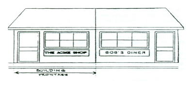
“Building Height.” The vertical distance measured from the established grade to the highest point of the roof surface for flat roofs; to the deck line of mansard roofs; and to the average height between eaves and ridge for gable, hip and gambrel roofs. Where a building is located on sloping terrain, the height may be measured from the average ground level of the grade at the building wall.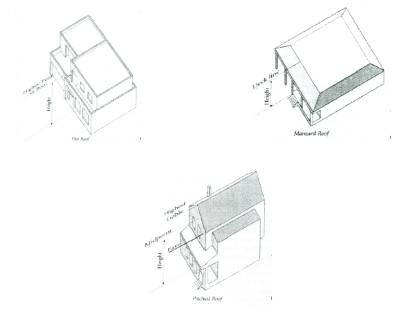
“Building Line.” A line established on a parcel which is parallel to a street right-of-way line for the purpose of prohibiting construction of a building between such line and an easement, right-of-way, or public area.
"Business Incubator." An organization that helps startup companies and individual entrepreneurs to develop their businesses by providing full-scale range of services including management training, office space, and financing.
“Business, Retail.” A commercial establishment that provides, as its primary activity, sales of goods to other commercial establishments. Examples of such uses include, but are not limited to, office furniture stores and office supply stores.
"Business, Service.” A commercial establishment that provides, as its primary activity, sales of services to other commercial establishments. Examples of such uses include, but are not limited to, uniform and linen services.
"Campground." A publicly or privately owned parcel of land designed, designated, maintained, intended, or used for the purpose of supplying a location for seasonal, recreational, and temporary living purposes in tents, trailers, travel trailers, motor home, cabins or similar facilities, whether or not a fee or charge is paid for the rental thereof, but does not include a mobile home or a mobile home park. Campgrounds are prohibited under this UDO.
“Canopy.” A projection from a building made from any material, which is cantilevered, suspended or supported on columns intended only for shelter or ornamentation.
“Cemeteries.” Land used or intended to be used for the burial of the human or animal dead and dedicated for cemetery purposes, including crematories, mausoleums and MORTUARIES, if operated in connection with and within the boundaries of such cemetery.
“Check-Cashing Business.” Any business that is licensed, or is required to be licensed, under ORC 1351.21 through 1351.30 to cash checks. Check-cashing business does not include any bank, savings and loan, credit union or similar financial institution doing business under authority granted by the Ohio Superintendent of Financial Institutions or by the equivalent regulatory authority of another state of the United States. Check-cashing businesses are not permitted under this UDO.
“City.” The incorporated municipality of Franklin, Ohio. For the purposes of this UDO, the term “City” shall also include Franklin City Council, Planning Commission, Appeals Board, Technical Review Committee, and/or City administrative staff or employees.
“City Engineer.” The person holding the title of City Engineer of the City of Franklin, or their designee.
"City Manager.” The person holding the title of City Manager of the City of Franklin, or their designee.
“Clear Sight Triangle.” The triangular area formed by a diagonal line connecting two points located on intersecting lines of a RIGHT-OF-WAY, EASEMENT of access, or pavement edge of an access drive, each point being 20 feet from the intersecting lines and extending vertically from a height of three feet above grade to 10 above grade.
“Co-location.” The use of a wireless telecommunications facility by more than a single wireless telecommunications provider.![]()
"Club, Private or Membership." Organizations that generally have some meaningful conditions for membership, with operations often controlled by the membership, and whose facilities and activities are only open to members and their guests.
“Commercial Entertainment.” A commercial establishment that provides, as its PRIMARY ACTIVITY, space for various types of sporting and/or leisure activities. Examples of such uses include, but are not limited to, skating rinks, bowling alleys, indoor playgrounds and movie theaters.
"Commercial Event Center.” Any private land at least 20 contiguous acres in size available and developed for educational purposes through recreational, spiritual, cultural and/or aesthetic uses, which use(s) are privately owned and privately operated with or without the intention of earning a profit in furtherance of such use. A combination of related uses may be incorporated, such as temporary and permanent lodging, indoor and outdoor recreation, camp offices, gymnasiums, auditoriums, cafeterias and additional similar uses and ancillary uses related thereto. Campgrounds are prohibited under this UDO, however a temporary site for tents or similar non-permanent shelters for outdoor lodging shall be a permitted ancillary use.
“Commercial Recreation/Fitness, Indoor and Outdoor.” Facilities for sports, recreational, and entertainment activities that may be conducted outdoor or indoor such as soccer, bowling, skating, swimming, sports courts, golf courses, driving ranges, and similar indoor activities taking place inside an enclosed building
“Commercial Training.” A commercial establishment (excluding any Educational Facilities (pre-K through 12th grade) or Secondary Education/Colleges/Universities) that provides, as its primary activity, any type of training, vocational, self-help or special interest to the general public for a fee. Examples of such uses include, but are not limited to, dance studios, beauty schools, and martial arts studios.
“Common Open Space.” Squares, greens, neighborhood parks, and linear environmental corridors, which may be owned and maintained by the City, a Homeowners' Association, Condominium Owners' Association or Developer.
“Comprehensive Development Plan or Comprehensive Land Use Plan.” The plan, which may consist of several maps, data and other descriptive matter, for the physical development of the City and which has been adopted by the Planning Commission and Council to indicate the general locations for proposed planning areas, major streets, parks, schools, public building sites and other similar information.
“Conditional Use.” A use that may be permitted within a zoning district (other than a principally permitted use), which is required to fulfill additional requirements because of its potential impact on the surrounding community. Such a use requires application for a conditional use and approval by the Planning Commission.
“Condominium.” A form of real property ownership in which a declaration has been filed submitting the property to the condominium form of ownership pursuant to ORC 5311. and under which each owner has an individual ownership interest in a unit with the right to exclusive possession of that unit and an undivided ownership interest with the other unit owners in the common elements of the condominium property.
“Condominium Owners' Association.” The organization that administers condominium property and that consists of all the owners of units in a condominium property.
"Construction.” For the purposes of this UDO, construction is deemed to begin when all necessary excavation and piers or footing of one or more principal buildings, or the installation of required infrastructure, has been completed or substantially begun.
"Construction Trailer." A mobile structure that is used to accommodate temporary offices, facilities, or storage of materials during an active construction project.
“Corner Lot.” See Lot.
“Council.” The Council of the City of Franklin, Ohio.
“Covering.” Any clothing or wearing apparel, including pasties, but not including any substance that can be washed off the skin, such as paint or make up, or any substance designed to simulate the appearance of the anatomical area beneath it.
“Credit Service Organization.” Any business that is registered, or is required to be registered, under ORC 4712.01 to 4712.14 to provide credit services as defined in ORC 4712.01(C). Credit service organization does not include any bank, savings and loan, credit union or similar financial institution doing business under authority granted by the Ohio Superintendent of Financial Institutions or by the equivalent regulatory authority of another state of the United States. Credit service organizations are not permitted under this UDO.
“Critical Storm.” A storm that is calculated by means of the percentage increase in volume of runoff by a proposed earth disturbing activity or development area. The critical storm is used to calculate the maximum allowable storm water discharge rate from a site.
“Crosswalk.” A right-of-way, dedicated to public use, which crosses a block to facilitate pedestrian access to adjacent streets and adjacent properties.
“Crown.” The upper mass or head of a tree.
“Cultivar.” A cultivated variety of plant material grown for its special form and characteristics.
“Cul-de-sac.” A short street having one open end and being permanently terminated by a vehicular turn-around.
“Curb Radius.” The curved edge of streets at an intersection measured at the outer edge or face of the street curb or of the parking lane.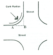
“Cut.” An excavation; the difference between a point on the original grade and a designated point of lower elevation on the final grade.
“Day Care Center, Adult.” Any place where adult day care services are provided, with or without compensation, for a daily average of five or more adults, excluding relatives of the owner or administrator of the center.
“Day Care Center, Child.” Any place where child day care and/or learning experiences are provided, with or without compensation, for a daily average of five or more infants, preschool children or school-age children (outside of school hours), excluding children of the owner or administrator of the center.
Day Care Home, Type A." The permanent residence of the administrator in which childcare is provided for seven to 12 children at one time or a permanent residence of the administrator in which childcare is provided for four to 12 children at one time if four or more children at one time are under two years of age. In counting children for the purpose of this definition, any children under six years of age who are related to the administrator or any employee on the premises shall be counted.
“Day Care Home, Type B.” The permanent residence of the administrator in which childcare is provided for one to six children at any one time and in which no more than three children are under two years of age at one time. In counting children for the purposes of this division, any children under six years of age who are related to the administrator or any employee on the premises shall be counted.
“Deciduous.” Plant material that normally sheds its foliage at the end of the growing season.
“Deck.” A platform, without a roof, that is either:
- Freestanding or directly adjacent to a principal building; or
- Attached to the building.
“Dedication.” The granting, by the property owner, of land by fee simple, or an easement therein, for the use of the public and accepted by council for such use by, or on behalf of, the public.
“Detention Basin.” A normally dry bottom impoundment area created by constructing an embankment, excavating a pit, or both, for the purpose of temporarily storing stormwater and gradually releasing the stored water at a controlled rate.
“Detention Facility.” A detention basin or alternative structure designed to temporarily store stormwater runoff and gradually release the stored water at a controlled rate.
“Developer.” Any person, corporation, association, partnership or other entity who creates or proposes to create a residential, commercial, industrial, or mixed use development, all or a portion of which will be located within the City.
"Development .” Any man-made change to improved or unimproved real estate including, but not limited to, buildings or other structures, mining, dredging, filling, grading, paving, excavation, or drilling operations or storage of equipment and materials.
“Development Area.” Any contiguous area owned by one person or operated as one development unit included within the scope of the regulations of this UDO, upon which earth-disturbing activities are planned or underway.
“Development Plan.” A plan submitted with an application for a Planned Unit Development District, in accordance with the requirements of Section 1109.05 of this UDO.
“Direct Recharge Area.” That portion of a drainage basin in which water infiltrating vertically from the surface will intercept the water table.
"Distribution Center." A facility used for receiving, temporarily storing, and distributing of goods according to orders as they are received. Distribution centers serve as a bridge between manufacturers and suppliers by receiving pallet pack and bulk products and redistributing and shipping it to wholesale or retail customers. There is no customer-direct pick-up or access to these facilities.
“District.” See Zoning District.
“DNR.” The Ohio Department of Natural Resources.
"Drive-Through Facility.” Any operation by a business establishment where the transfer of goods and services to the customers is accomplished through an opening in the building while the customer remains in their vehicle.
“Dwelling or Dwelling Unit.” Any building or portion thereof designed, intended or used primarily for residential purposes (i.e., human habitation), including cooking and sanitary facilities. The term does not include a tent, cabin, trailer, mobile home, boarding house, or hotel. For the purposes of this UDO, dwellings shall be defined as the following types:
- Dwelling, Accessory Unit: A secondary dwelling unit established in conjunction with, and clearly subordinate to, a primary dwelling unit, which is only occupied by a member(s) of the family of the dwelling's owner(s), who is related to the owner(s) by blood, marriage or adoption.
- Dwelling, Four Family: A building or portion thereof designed, intended or used primarily for residential purposes to be occupied by more than four families living independently of one another.
- Dwelling, Live-Work: A live/work dwelling is a single unit that consists of both a commercial or office use and a residential component that is occupied by the same occupant. The live/work unit shall be the primary dwelling of the occupant, and no portion of the live/work unit may be rented or sold separately.
- Dwelling, Multi-family: A building or portion thereof designed, intended or used primarily for residential purposes to be occupied by more than five families living independently of one other.
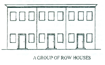
- Dwelling, Row House: A building or portion thereof designed, intended or used primarily for residential purposes. Row house dwellings are situated so that their sidewalls are shared with other like structures, all having their own separate entrances and being separate lots of record.
- Dwelling, Single-Family:A building designed, intended or used primarily for residential purposes to be occupied by one family.
- Dwelling, Three-Family: A building or portion thereof designed, intended or used primarily for residential purposes to be occupied by not more than three families living independently of one another.
- Dwelling, Two-Family: A building or portion thereof designed, intended or used primarily for residential purposes to be occupied by two families living independently of one another.
- Dwelling, Upper Floor: A single unit or multiple units above ground level of an existing structure providing complete, independent living facilities for one or more individuals and including the permanent provision for living, sleeping, eating, cooking and sanitation.
“Earth-Disturbing Activity.” Any grading, excavation, filling,or other alteration of the earth's surface where natural or man-made ground cover is destroyed.
“Easement.” A right-of-use over or in the property of another, granted by the owner for specific public or semi- public purposes and accepted by Council for such use by, or on behalf of, the public.
"Educational Facilities (Pre-K through 12th Grade).” Any institution organized and operated under the laws of Ohio to provide regular courses of instruction for students in kindergarten through grade 12 by the Ohio Department of Education or by an accrediting association recognized by the United States Office of Education.
“Efficiency or Efficiency Unit.” Efficiencies shall be regulated by the Ohio Building Code, and those provisions of the Building Code regulating efficiencies shall take precedence over the provisions of this UDO.
“Elderly Housing.” An age-restricted residential development in any housing form that qualifies for an exemption as “housing for older persons” under the Federal Fair Housing Amendments Act of 1988, 42 USC 3607(b), and any amendments thereto.
"Electric Vehicle (EV) Charging Station.” Equipment that connects an electric vehicle (EV) to a source of electricity to recharge electric vehicles.
“Electric Vehicle (EV) Charging Station, Level 1.” A slow speed charging station that typically operates on a 15- or 20-amp breaker on a 120-volt Alternating Current (AC) circuit.
“Electric Vehicle (EV) Charging Station, Level 2.” A medium speed charging station that typically operates on a 40- to 100-amp breaker on a 208- or 240-volt Alternating Current (AC) circuit.
“Electric Vehicle (EV) Charging Station, Level 3.” A high speed charging station that operates on a high voltage circuit.
"Emergency.” A reasonably unforeseen occurrence with a potential to endanger personal safety or health, or cause substantial damage to property, which calls for immediate action.
“Enclosure Below the Lowest Floor.” See “Lowest Floor.”
“Engineer.” A person licensed by the State of Ohio and registered as a professional engineer under ORC 4733.
"Event Venue, Indoor or Outdoor.” A building, structure, or open air facility which is rented by individuals or groups to accommodate events including, but not limited to, banquets, weddings, birthday parties, anniversaries, and receptions.
“Environmental Sciences.” These uses are permitted in the Office-Research Park District and include, but are not limited to, the following uses: laboratories engaged in testing and research, pharmaceutical laboratories, and bionomic laboratories. All operations are carried on in a completely enclosed building.
“EPA.” The Ohio Environmental Protection Agency.
“Equipment Shelter and/or Cabinet.” The structure in which the electronic receiving and relay equipment for a Wireless Telecommunications Facility is housed.
“Essential Services.” The erection, construction, alteration or maintenance by public utilities or by governmental entities of underground, surface or overhead gas, electrical, telephone, telegraph, steam, fuel or water transmission or distribution systems, collection, communication, supply or disposal systems, including towers, poles, wires, mains, drains, sewers, pipes, conduits, cables, fire alarm and police call boxes, traffic signals, hydrants and similar accessories in connection therewith (but not including buildings) that are necessary for the furnishing of adequate service by such utilities or governmental entities for the general health, safety or welfare.
"Essential Services and Utilities, City Owned." The erection, construction, alteration, or maintenance, by the City of Franklin of gas, electrical, steam, or water generation, transmission or distribution systems, collection, supply, or disposal systems, on land owned by the City of Franklin as a means of supporting a governmental facility. City owned essential services and utilities shall be permitted as authorized and regulated by law and other ordinances of the City, it being the intention hereof to exempt such essential services and utilities from the application of this code.
“Evergreen.” Plant material that has foliage that remains green throughout the year.
“Excavation.” Any breaking of ground except common household gardening and ground care.
“Executive Order 11988 (Floodplain Management).” This order was issued by President Carter in 1977, and requires that no federally-assisted activities be conducted in, or have the potential to, affect identified SPECIAL FLOOD HAZARD AREAS unless there is no practicable alternative.
“FAA.” The Federal Aviation Administration, and any legally appointed, designated or elected agent or successor.
“FCC.” The Federal Communications Commission and any legally appointed, designated, or elected agent or successor.
“Family.” One or more individuals occupying a single dwelling unit, provided that unless all individuals are related by blood, marriage or adoption, no family shall contain over five individuals but further provided that a family related by blood, marriage or adoption may have a total of two non-related individuals living with it.
“Farm Market.” The offering for sale of fresh agricultural products directly to the consumer in an open-air market.
“Federal Emergency Management Agency (FEMA).” The agency with the overall responsibility for administering the National Flood Insurance Program.
“Festivals and Circuses.” A temporary civic, recreational, fund-raising, or promotional activity or event that typically has a specific focus with its own social activities, food, music, or ceremonies. Such use typically takes place in a specified location and on a specific day or days.
“Fill or Filling.” Any act by which earth, sand, gravel, rock or any other material is placed, pushed, dumped, pulled, transported or moved to a new location above the natural surface of the ground or on top of the stripped surface and shall include the resulting grade conditions; the difference in elevation between a point on the original ground and a designated point of higher elevation on the final grade.
“Final Plat.” A final map of all or part of the subdivision prepared and certified by an registered engineer or surveyor in accordance with the requirements and regulations of this UDO, which is submitted to the City for final approval before recording at the office of the Warren County Recorder.
“Five-Year Capture Area.” The area around protected public water supply/well fields delineated by the five-year travel time contour.
“Flag.” Any fabric, banner or bunting containing distinctive colors, patterns or symbols, used as a symbol of domestic government, political subdivision or other governmental agency, and attached to or designed to be flown from a flagpole or similar device.
“Flag, International.” Any fabric, banner or bunting containing distinctive colors, patterns or symbols, used as a symbol of a foreign country or government, and attached to or designed to be flown from a flagpole or similar device.
“Flashing.” A sign or graphic which in any manner, as a whole or in part, physically changes in light intensity or gives the appearance of such change.
"Fleet Vehicle." A vehicle that is owned or operated by the person, company, or business on the premises, and which is used for purposes of delivery, pick-up, or service to patrons of the primary use. A fleet vehicle may also be a commercial vehicle, but does not include semi-tractor, semi-trailer, any non-recreational trailer used for commercial purposes, or any heavy construction equipment.
“Flood or Flooding.” A general or temporary condition of partial or complete inundation of normally dry land areas from:
- The overflow of inland or tidal waters, and/or
- The unusual and rapid accumulation or runoff of surface waters from any source.
“Flood Hazard Boundary Map (FHBM).” Usually the initial map, produced by the Federal Emergency Management Agency, or U.S. Department of Housing and Urban Development, for a community depicting approximate special flood hazard areas.
“Flood Insurance Rate Map (FIRM).” An official map on which the Federal Emergency Management Agency or the U.S. Department of Housing and Urban Development has delineated the areas of special flood hazard.
“Flood Insurance Risk Zones.” Zone designations on FHBMs and FIRMs that indicate the magnitude of the flood hazard in specific areas of a community. Following are the zone definitions:
- Zone A: Special flood hazard areas inundated by the 100-year flood; in any given year base flood elevations are not determined.
- Zones A1-30 and Zone AE: Special flood hazard areas inundated by the 100-year flood in any given year; base flood elevations are determined.
- Zone AO: Special flood hazard areas inundated by the 100-year flood; with flood depths of one to three feet (usually sheet flow on sloping terrain); average depths are determined.
- Zone AH: Special flood hazard areas inundated by the 100-year flood in any given year; flood depths of one to three feet (usually areas of ponding); base flood elevations are determined.
- Zone A99: Special flood hazard areas inundated by the 100-year flood to be protected from the 100-year flood by a Federal flood protection system under construction; no base flood elevations are determined.
- Zone B and Zone X (shaded): Areas of 500-year flood; areas subject to the 100-year flood with average depths of less than one foot or with contributing drainage area less than one square mile; and areas protected by levees from the base flood .
- Zone C and Zone X (unshaded): Areas determined to be outside the 500-year floodplain.
“Flood Insurance Study (FIS).” The official report in which the Federal Emergency Management Agency or the U.S. Department of Housing and Urban Development has provided flood profiles, floodway boundaries (sometimes shown on flood boundary and floodways maps), and the water surface elevations of the base flood.
“Floodplain.” Special flood areas that are subject to periodic inundation. Construction and development within the Floodplain requires a Floodplain Development Permit.
“Floodplain Overlay Map or Flood Boundary Map (FHBM).” Usually the initial map, produced by FEMA or the U.S. Department of Housing and Urban Development (HUD) for a community depicting approximate special flood hazard areas; the City's Floodplain Overlay District Map, as included in the UDO.
“Flood Protection Elevation.” The Flood Protection Elevation, or FPE, is the base flood elevation plus one foot of freeboard. In areas where no base flood elevations exist from any authoritative source, the flood protection elevation can be historical flood elevations, or base flood elevations determined and/or approved by the Floodplain Administrator.
“Floodproofing.” Any combination of structural and non-structural additions, changes, or adjustments to structures which reduce or eliminate flood damage to real estate or improved real property, water and sanitary facilities, structure and their contents.
“Floodway.” A floodway is the channel of a river or other watercourse and the adjacent land areas that have been reserved in order to pass the base flood discharge. A floodway is typically determined through a hydraulic and hydrologic engineering analysis such that the cumulative increase in the water surface elevation of the base flood discharge is no more than a designated height. In no case shall the designated height be more than one foot at any point within the community. The floodway is an extremely hazardous area, and is usually characterized by any of the following: moderate to high velocity flood waters, high potential for debris and projectile impacts, and moderate to high erosion forces.
"Floor Area.” The sum of the horizontal areas of each floor of a building, measured from the exterior faces of the exterior walls or from the centerline of walls separating two buildings. The gross floor area measurement is exclusive of areas of unfinished basements, unfinished cellars, unfinished attics, attached garages, space used for off-street parking and loading, breezeways, porches and decks, and accessory structures. Unfinished basements, unfinished cellars, and unfinished attics shall be counted as storage space for purposes of determining required parking spaces.
“Floor Area, Seating Capacity.” Floor area that is used or intended for use to serve patrons, clients or customers and all that area devoted to employee workspace. Such floor area as is used or intended to be used principally for the storage or merchandise, hallways, elevator or stair bulkheads or for utilities or sanitary facilities shall be excluded from the computation of floor area. Measurement of useable floor area shall be the horizontal areas of the several floors of the buildings, measured from the exterior faces to the exterior walls.
"Food Service/Catering.” Establishments that prepare, as their primary economic function, meals, snacks, and beverages for immediate consumption that are transported to an off-premises site or at banquet halls with catering staff. Examples of events catered by these establishments include weddings, trade shows, parties and luncheons.
“Freeboard.” A factor of safety usually expressed in feet above a flood level for the purposes of floodplain management. Freeboard tends to compensate for the many unknown factors that could contribute to flood heights greater than the height calculated for a selected size flood and floodway conditions, such as wave action, obstructed bridge openings, debris and ice jams, and the hydrologic effect of urbanization in a watershed.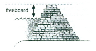
“Front Lot Line.” See Lot.
“Front Yard. See Yard.
"Fulfillment Center." A third-party logistics warehouse that receives products and goods from suppliers, processes orders from e-commerce retailers, and ships products directly to individual consumers.
“Garages and Carports, Detached.” A building or structure, or part thereof, used or designed to be used for parking and storage.
"Government Facility." Any buildings, structure, or use, or portion thereof, used by a governmental agency for administrative or service purposes, but not including buildings devoted solely to the storage and maintenance of equipment and materials.
“Grade (ground level).” The average of the finished ground level at the center of all walls of a BUILDING. In case walls are parallel to and within five feet of a sidewalk, the above ground level shall be measured at the sidewalk, unless otherwise defined within this UDO.
“Greenbelts.” A strip or parcel of land, privately restricted or publicly dedicated as open space, located between a residential development and other incompatible uses, for the purpose of protecting and enhancing the residential environment (See also buffer).
“Ground Satellite Station.” Any antenna or earth station designed, constructed or modified to bring in or receive satellite television signals.
“Half-Street.” A street having a lesser right-of-way width than required for a street of full width.
“Hard Surface.” A bituminous surface, Portland cement concrete, brick pavers or other surface as approved by the City Engineer. “Hard Surface” does not include gravel.
“Historic structure.” Any structure that is:
- Listed individually in the National Register of Historic Places (a listing maintained by the U.S. Department of Interior) or preliminarily determined by the Secretary of the Interior as meeting the requirements for individual listings on the National Register;
- Certified or preliminarily determined by the Secretary of the Interior as contributing to the historical significance of a registered historic district or a district preliminarily determined by the Secretary to qualify as a registered historic district; or
- Individually listed on the State of Ohio's inventory of historic places maintained by the Ohio Historic Preservation Office.
- Individually listed on the inventory of historic places maintained by the City of Franklin’s historic preservation program, which program is certified by the Ohio Historic Preservation Office.
“Health Commissioner.” The Warren County Commissioner of Health or his authorized representative.
“Height, or Above Ground Level (AGL).” When referring to a tower or other structure, the distance measured from the finished grade at the base of the toweror structure to the highest point on the tower or other structure, including the base pad and any antenna.
“Home Occupation Type-A.” This type of home occupation has little or no impact on the surrounding residential area and requires no permit. In general, a Home Occupation Type A is located and conducted so that the average neighbor, under normal circumstances, would not be aware of its existence.
“Home Occupation Type-B.” This type of Home Occupation has the potential for greater impact on the surrounding residential area and therefore requires a Conditional Use Permit.
“Homeowners' Association.” A private, nonprofit corporation of homeowners established by a developer or group of developers, with local government approval, whose purpose is to own, operate and maintain various common properties, including, but not limited to, common open space, private streets and recreation facilities. The association/corporation holds title to common property.
“Hospitals.” An establishment for the medical, surgical or psychiatric care of bed patients for a continuous period longer than 24 hours, which is open to the general public 24 hours each day for emergency care, has a minimum of 10 patient beds, an average of 2,000 patient days per annum, and has on duty a registered nurse 24 hours each day.
“Hotel.” A building occupied as the more-or- less temporary abiding place of individuals who are lodged with or without meals in which there are 10 or more sleeping rooms and no provision made for cooking in any individual room or apartment, and no individual room or apartment is accessible from the exterior of the building. A hotel may include restaurants or cocktail lounges, public banquet halls, ballrooms or meeting rooms.
“Hydrologic and Hydraulic Engineering Analysis.” An analysis performed by a professional engineer, registered in the State of Ohio, in accordance with standard engineering practices as accepted by FEMA, used to determine flood elevations and/or floodway boundaries.
“Incorporated Territory.” Land included within the boundaries of the City.
“Industrial, Artisan.” An establishment or business where an artist, artisan, or craftsperson teaches, makes, or fabricates crafts or products by hand or with minimal automation, and which may include direct sales to consumers. This definition includes uses such as small-scale fabrication, manufacturing, and other industrial uses and processes such as small-scale welding and sculpting. This use includes fabrication implements that are more industrial than that of an art studio and includes coopering, and crafting of cabinetry, furniture, and other similar small-scale manufacturing.
"Industrial, Heavy." An industrial establishment that provides, as its primary activity, space for the assembly, manufacturing, processing or warehousing of goods or products, and which typically involve external impacts such as noise, dust, smoke, fumes, odors, heavy truck and/or rail traffic or other objectionable characteristics. Such use may have outdoor storage and/or operation space. Examples of such uses include goods produced by factory assembly, paper mills, fabrication and assembly of metal products. General Industry does not include junkyards, recycling centers, recycling plants, salvage/scrap yards, scrap metal processing facilities, and uses of similar intensity.
"Industrial, Light." A commercial or industrial establishment that provides, as its primary activity, space for the assembling or processing of goods for sale, or service industries, that do not produce any noise, dust, odor, fumes, vapors, smoke, vibrations, glare, heat, noise, odor, heavy truck or rail traffic, or other objectionable effects on the outside of the building. All operations are carried on in a completely enclosed building. Examples of such uses include food processing, beverage bottling, upholstering, carpets and rugs, business machines, dry cleaning and dyeing, and construction machinery.
“Information Technology/Data Center.” These uses are permitted in the Office-Research Park District and include, but are not limited to, the following uses: telecommunications, data processing and computing centers, computer electronic parts, equipment and electronics manufacturing, computer programming and software development, and internet-related businesses. All operations are carried on in a completely enclosed building.
"Integral." Something that is essential, necessary, or fundamental to a whole.
“Interior Lot.” See Lot.
"Junk." Old or scrap copper, brass, rope, rags, batteries, paper, rubber, trash waste, iron, steel and other old or scrap ferrous or nonferrous materials.
"Junkyard." An establishment or place of business, other than an establishment having facilities for processing iron, steel or nonferrous scrap and whose principal product is scrap iron and steel or nonferrous scrap for sale for remelting purposes, which is maintained or operated for the purpose of storing, keeping, buying or selling junk, and includes garbage dumps and sanitary landfills. The term "junk yard" shall also include scrap metal processing facilities which are located within 1,000 feet of the nearest edge of the right-of-way of a highway in the interstate or primary system.
"Kentucky Board Fencing." A wooden fence that typically includes three or four horizontal boards that are attached to wooden posts and which are spaced to allow air flow between each board. Such fences may or may not include welded wire between the boards.
“Landfill.” The burial of non-hazardous and non-medical farm, residential, institutional, commercial or industrial waste.
“Landing Field.” A specific area designated for the take-off and landing of aircraft.
"Landscaping.” The use of natural plant materials including, but not limited to, groundcovers, shrubs, and trees (deciduous and evergreen). Landscaping also involves the placement, preservation and maintenance of said plant materials and includes such elements as fences, walls, lighting and earth mounding.
"Large Equipment." movable or transportable vehicle or other apparatus commonly use in commercial, industrial, or construction enterprises, such as but not limited to trailers, bulldozers, cranes, backhoes, rollers, loaders, and lifts having a gross weight of 2.5 tons or more. This definition does not include semi-trucks.
“Large Equipment Retail, Rental, and Repair.” An establishment for the sale, rental, and repair of large equipment as defined in this UDO.
"Letter of Map Change (LOMC).” A Letter of Map Change is an official FEMA determination, by letter, to amend or revise effective flood insurance rate maps, flood boundary and floodway maps, and flood insurance studies. LOMC's are broken down into the following categories:
- Letter of Map Amendment (LOMA): A revision based on technical data showing that a property was incorrectly included in a designated special flood hazard area. A LOMA amends the current effective flood insurance rate map and establishes that a specific property is not located in a special flood hazard area.
- Letter of Map Revision (LOMR): A revision based on technical data that, usually due to manmade changes, shows changes to flood zones, flood elevations, floodplain and floodway delineations, and planimetric features. One common type of LOMR, a LOMR-F, is a determination concerning whether a structure or parcel has been elevated by fill above the base flood elevation and is, therefore, excluded from a special flood hazard area.
- Conditional Letter of Map Revision (CLOMR): A comment by FEMA regarding a proposed project that would, upon construction, affect the hydrologic or hydraulic characteristics of a flooding source and thus result in the modification of the existing regulatory floodway, the effective base flood elevations, or the special flood hazard area. A CLOMR does not amend or revise effective flood insurance rate maps, flood boundary and floodway maps, or flood insurance studies.
“Life Sciences.” These uses are permitted in the Office-Research Park District and include, but are not limited to, the following uses: biotechnology, biopharmaceutical, biomedical, pharmaceuticals, and/or laboratories engaged in testing and research, and the manufacture of medical instruments, appliances, apparatus or filters. All operations are carried on in a completely enclosed building.
“Live Viewing Booth.” Any private or semi private booth, or any viewing room of less than 150 square feet of floor space, to which the public may gain admittance, wherein a live performance is presented to five or fewer individuals at any one time.
“Loading Space.” An off-street space on the same lot with a building or group of buildings for the temporary parking of a commercial vehicle while loading and unloading merchandise or materials.
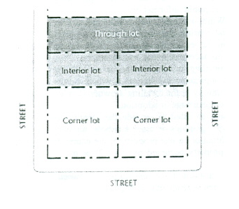
“Lot.” The basic development unit; a parcel of land with fixed boundaries occupied, or to be occupied by, a main building, or a group of such buildings and accessory structures, or used for the principal use and uses accessory thereto, together with such open spaces as are required under the provisions of this UDO. Every lot shall abut upon and have permanent access to a public street and have a minimum frontage of 40 feet thereon.
- Corner Lot: A lot that has at least two contiguous sides abutting upon a street for its full length.
- Interior Lot: A lot other than a corner or through lot.
- Through Lot: Any lot having frontages on two or more streets as distinguished from a corner lot. In the case of a row of double frontage lots, all sides of such lots adjacent to streets shall be considered frontage, and front yards shall be provided as required.
“Lot Area.” The total horizontal area within the lot lines of a lot.
“Lot Coverage.” The part or percent of a lot occupied by buildings, including accessory structures buildings.
“Lot Depth.” A distance measured in the mean direction of the side lot lines from the mid-point of the front lot lines to the mid-point of the rear lot line.
“Lot Line.” The lines bounding a lot or, in some instances, the right-of-way line or public easement line on a lot.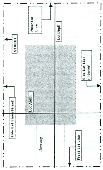
“Lot Line, Front.” The line separating a lot from the street. In the case of a corner lot or double frontage lot, the front lot line means the line separating such lot from both streets.
“Lot Line, Rear.” The lot line opposite the front lot line. In the case of a lot pointed at the rear, the rear lot line shall be an imaginary line parallel to the front lot line, not less than 10 feet long, lying farthest from the front lot line and wholly within the lot. In the case of a corner lot, the rear lot line is opposite the front lot line of least dimension.
“Lot Line, Side.” Any lot line other than the front lot line or rear lot line. A side lot line separating a lot from a street is a street lot line. A side lot line separating a lot from another lot or lots is an interior side lot line.
“Lot of Record.” - A parcel of land, the dimensions of which are shown on a document or map on file with the Warren County Recorder's Office or in common use by City or Warren County officials, and which actually exists as so shown, or any part of such parcel held in a record ownership separate from that of the remainder thereof.
“Lot Width.” The horizontal distance between the side lot lines, measured at the two points where the building line or setback line intersects the side lot lines.
“Lowest Floor.” The lowest floor of the lowest enclosed area (including basement) of a structure. This definition excludes an “enclosure below the lowest floor” which is an unfinished or flood resistant enclosure usable solely for parking of vehicles, building access or storage, in an area other than a basement area, provided that such enclosure is built in accordance with the applicable design requirements specified in these regulations for enclosures below the lowest floor.
“Main Building.” A building in which is conducted the principal use of the lot upon which it is situated.
“Main Use.” The principal use to which the premises are devoted and the principal purpose for which the premises exist.
“Major Subdivision.”
- The division of any parcel of land shown as a unit or as contiguous units on the last preceding tax roll, into three or more lots, sites or parcelsPARCELS, any one of which is less than five acres for the purpose, whether immediate or future, of transfer of ownership; or the division of any parcel of land into two or more lots, sites or parcels of any size that involves the creation of any new streets, public rights-of-way or easements of access; provided, however, that the division or partition of land into parcels of more than five acres not involving any new streets, public rights-of-way or easements of access, and the sale or exchange of parcels between adjoining lot owners, where such sale does not create additional building sites, shall be exempt from the platting procedures of this UDO but shall not be exempt from the improvement, development or redevelopment standards of this UDO.
- The improvement of one or more parcels of land for residential, commercial or industrial structures or groups of structures involving the division or allocation of land for the opening, widening or extension of any street or streets, except private streets serving industrial structures; and/or the division or allocation of land as common open space for common use by owners, occupants or lease holders or as easements for the extension and maintenance of public sewer, water, storm drainage or other public facilities. (See also minor subdivision; subdivision, major; and subdivision, minor).
“Major Tree.” A living tree with a trunk diameter of at least 15 inches , measured two feet above ground level.
“Manufactured Home.” A building unit or assembly of closed construction that is fabricated in an off-site facility and constructed in conformance with the federal construction and safety standards established by the secretary of housing and urban development pursuant to the Manufactured Housing Construction and Safety Standards Act of 1974, 88 Stat. 700, 42 USCA 5401, 5403, and that has a permanent label or tag affixed to it, as specified in 42 USCA 5415, certifying compliance with all applicable federal construction and safety standards. (PER FEMA: A structure, transportable in one or more sections, which is built on a permanent chassis and is designed for use with or without a permanent foundation when connected to the required utilities. The term "manufactured home" does not include a "recreational vehicle". For the purposes of these regulations, a manufactured home includes manufactured homes and mobile homes as defined in Chapter 4781 of the Ohio Revised Code.)
“Manufactured or Mobile Home Park.” As specified in the Ohio Administrative Code 4781-12-01, a manufactured or mobile home park means any tract of land upon which three or more manufactured homes or mobile homes, used for habitation are parked, either free of charge or for revenue purposes, and includes any roadway, building, structure, vehicle, or enclosure used or intended for use as part of the facilities of the park. A tract of land that is subdivided and the individual lots are not for rent or rented, but are for sale or sold for the purpose of installation of manufactured homes on the lots, is not a manufactured home park, even though three or more manufactured homes are parked thereon, if the roadways are dedicated to the local government authority. Manufactured home park does not include any tract of land solely for the storage or display for sale of manufactured homes. Manufactured Home Parks and Mobile Home Parks are not permitted under this UDO.
"Makerspace." A communal public workshop in which makers can work on small personal projects. Makerspace may be a principal use or an accessory use to an office , school, library, or other similar use.
“Marquee.” A permanent roofed structure attached to and supported by the building and projecting beyond the building line or over public property.
“Material Sciences.” These uses are permitted in the Office-Research Park District and include, but are not limited to, the following uses: plastics/polymer research and engineering, laser technology and application, robotic research, and the manufacturing, processing and/or packaging of medical, optical, scientific, electronic or electromagnetic devises, equipment, systems or supplies. All operations are carried on in a completely enclosed building.
“Mean sea level” For purposes of the National Flood Insurance Program, the National Geodetic Vertical Datum (NGVD) of 1929 or other datum, to which base flood elevations shown on a community's Flood Insurance Rate Map are referenced.
“Medical Center/Clinic.” A commercial or noncommercial establishment that provides, as its primary activity, health-related services to the general public on an outpatient basis. Such use shall not provide space for overnight treatment and may be set up with emergency vehicle receiving areas and trauma treatment facilities. . Examples of such uses include clinics and emergency clinics.
“Medical Office.” A commercial or noncommercial establishment that provides, as its primary activity, health-related services to the general public on an outpatient basis. Such use shall not provide space for overnight treatment. Examples of such uses include doctors' offices and dentists' offices.
“Microcell.” The lines that connect a provider's towers/cell sites to one or more cellular telephone switching offices, and/or long distance providers, or the public switched telephone network.
“Mining and Extraction.” All or any part of the process involved in the mining of minerals and raw materials by removing overburden and mining directly from the deposits, open- pit mining or minerals naturally exposed, mining by auger method, dredging and quarrying, or underground mining and surface work incidental to an underground mine. Such uses are not permitted in the City under this UDO.
“Minor Subdivision.” The division of any parcel of land shown as a unit or as contiguous units on the last preceding tax roll along an existing and improved public street, into not more than two lots or parcels, any one of which is less than five acres; or the division of any parcel of land into two or more lots of more than five acres not involving any new streets, public rights-of-way or easements of access; or the sale or exchange of parcels between adjoining lot owners, where such sale does not create additional building sites; or the combination or replatting of two or more lots or parcels into a single lot when such lots or parcels are under the ownership of the same owner and the combination or replatting does not involve any new streets, public rights-of-way or easements of access (See also major subdivision; subdivision, major; subdivision, minor).
"Mixed Use." A building, lot, or development that contains a mixture of uses including residential, commercial, office, institutional, or other similar uses. Such uses may be mixed within one building (either horizontally or vertically) or within an overall development.
"Mobile Home.” Means a building unit or assembly of closed construction that is fabricated in an off-site facility, is more than 35 feet in length or, when erected on site, is 320or more square feet , is built on a permanent chassis, is transportable in one or more sections, and does not qualify as a manufactured home or as an industrialized unit as defined in ORC 3781.06(C).
"Mobile Uses." A large, wheeled vehicle that is used for a specific purpose such as to cook, prepare, and/or serve food and/or beverages in individual portions in a ready to consume state; to conduct a specific medical procedure such as blood donations, immunizations, or medical evaluations; or to sell retail goods.
“Model Home.” A dwelling unit constructed within an approved residential subdivision or development that is temporarily used for the purpose of demonstrating building techniques, floor plans, interior finishes, or design features, and that may also serve as a temporary sales or leasing office for the sale or lease of lots or dwelling units. A model home is not intended as a permanent commercial use and shall be converted to a conforming residential use upon completion of sales activity.
"Monopole.” A support structure constructed of a single, self- supporting hollow metal tube securely anchored to a foundation.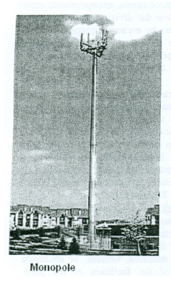
“Mortuaries.” An establishment providing services such as preparing the human dead for burial and/or cremation and arranging and managing funerals, hospitality and reception areas in connection therewith and which may include limited caretaker facilities. This definition includes crematoriums and columbariums.
“Motor Vehicle.” Any vehicle, including mobile homes and recreational vehicles, which is propelled or drawn by power other than muscular power or power collected from overhead electric trolley wires. Motor vehicle does not include motorized bicycles, equipment used in construction work and not designed for or employed in general highway transportation, well-drilling machinery, ditch-digging machinery, farm machinery, trailers that are used to transport agricultural produce or agricultural production materials between a local place of storage or supply and the farm when drawn or towed on a public road or highway at the speed of 25 miles per hour or less, threshing machinery, hay-baling machinery, corn sheller, hammermill and agricultural tractors, machinery used in the production of horticultural, agricultural, and vegetable products, and trailers that are designed and used exclusively to transport a boat between a place of storage and a marina, or in and around a marina, when drawn or towed on a public road or highway for a distance of no more than 10 miles and at a speed of 25 miles per hour or less (See also vehicle).
“Motor Vehicle, Collector's.” Any motor vehicle or agricultural tractor or traction engine that is of special interest, that has a fair market value of one hundred dollars or more, whether operable or not, and that is owned, operated, collected, preserved, restored, maintained, or used essentially as a collector's item, leisure pursuit, or investment, but not as the owner's principal means of transportation, and that displays current, valid license tags issued under ORC 4503.45, or a similar type of motor vehicle that displays current, valid license tags issued under substantially equivalent provisions in the laws of other states.
“Motor Vehicle, Commercial.” Any motor vehicle designed or used to transport persons or property that meets any of the following qualifications:
- Any combination of vehicles with a gross vehicle weight or combined gross vehicle weight rating of 26,001 pounds or more; provided the gross vehicle weight or gross vehicle weight rating of the vehicle or vehicles being towed in excess of 10,000 pounds;
- Any single vehicle with a gross vehicle weight or gross vehicle weight rating of 26,001 pounds or more;
- Any single vehicle or combination of vehicles that is not a class A or class B vehicle, but is designed to transport 16 or more passengers including the driver;
- Any school bus with a gross vehicle weight or gross vehicle weight rating of less than 26,001 pounds that is designed to transport fewer than 16 passengers including the driver;
- Is transporting hazardous materials for which placarding is required under subpart F of 49 CFR part 172, as amended; or
- Any single vehicle or combination of vehicles that is designed to be operated and to travel on a public street or highway and is considered by the federal Motor Carrier Safety Administration to be a commercial motor vehicle including, but not limited to, a motorized crane, a vehicle whose function is to pump cement, a rig for drilling wells, and a portable crane.
“Motor Vehicle, Noncommercial.” Any motor vehicle, including a farm truck as defined by ORC 4503.04, that is designed by the manufacturer to carry a load of no more than one ton and is used exclusively for purposes other than engaging in business for profit.
“Multi-Use Tower.” A self-supporting lattice, guyed or monopole structure, constructed from grade that supports more than one Wireless Telecommunications Facility.
“National Flood Insurance Program (NFIP).” The NFIP is a Federal program enabling property owners in participating communities to purchase insurance protection against losses from flooding. This insurance is designed to provide an insurance alternative to disaster assistance to meet the escalating costs of repairing damage to buildings and their contents caused by floods. Participation in the NFIP is based on an agreement between local communities and the Federal government that states if a community will adopt and enforce floodplain management regulations to reduce future flood risks to all development in special flood hazard areas, the Federal government will make flood insurance available within the community as a financial protection against flood loss.
“New Construction.” STRUCTURES for which the "START OF CONSTRUCTION" commenced on or after the effective date of a floodplain regulation adopted by City of Franklin and includes any subsequent improvements to such structures.
For the purposes of determining insurance rates, structures for which the “start of construction'' commenced on or after the effective date of an initial FIRM November 5, 1980 or after December 31, 1974, whichever is later, and includes any subsequent improvements to such structures.
“Nonconforming Building.” A building, or portion thereof, lawfully existing on the effective date of this UDO, or amendments thereto, and that does not conform to the lot, dimensional, height, yard, are or lot coverage regulations of the district in which it is located.
“Non-Routine Maintenance.” Activities necessary not more frequently than every 24 months to keep structures and equipment in good repair.
“Non-Structural Controls.” Stormwater runoff control and treatment techniques that use natural measures to control runoff and/or reduce pollution levels, and do not require extensive construction efforts and/or do promote runoff control and/or pollutant reduction by eliminating the runoff and/or pollutant source. Examples include minimizing impervious area, buffer strips along streams, and preserving natural vegetation.
“Nude or Semi-Nude Modeling Studio.” Any place where a individual who appears semi-nude or who displays specified anatomical areas is provided to be observed, sketched, drawn, painted, sculptured, photographed, or similarly depicted by other persons who pay money or any form of consideration. Nude Model Studio shall not include:
- A proprietary school licensed by the State of Ohio, or a college, junior college or university supported entirely or in part by public taxation;
- A private college or university that offers educational programs in which credits are transferable to a college, junior college, or university supported entirely or partly by taxation; or
- An establishment holding classes in a structure that has no sign visible from the exterior of the structure and no other advertising that indicates a semi-nude person is available for viewing; where in order to participate in a class a student must enroll at least three days in advance of the class; and where no more than one semi-nude model is on the premises at any one time.
“Nudity, State of Nudity or Nude.” Exposing to view the genitals, pubic area, vulva, perineum, anus, anal cleft or cleavage, or pubic hair with less than a fully opaque covering exposing to view any portion of the areola of the female breast with less than a fully opaque covering; exposing to view male genitals in a discernibly turgid state, even if entirely covered by an opaque covering; or exposing to view any device, costume, or covering that gives the appearance of or simulates any of these anatomical areas.
“Nursing Home.” See skilled nursing facility. A hospital shall not be construed to be a nursing home.
“ODOT.” The Ohio Department of Transportation.
"Office." A commercial establishment that provides, as its primary activity, space for any professional and/or business operation where the product is a person's knowledge or skill and not a commodity. Such use shall be completely contained within a building. "Office" does not include health-related services. Examples of such uses include, but are not limited to, law offices, real estate offices and corporate headquarters.
“Office, Co-Working.” A facility that is designed to accommodate people from different companies who come to do work. Such uses are characterized by shared facilities, services, and tools.
“Ohio Building Code (OBC).” Wherever the term “Ohio Building Code” or “Building Code” appears in this UDO, it shall mean the Ohio Building Code, for commercial and industrial uses, or Residential Code of Ohio, for residential uses, as determined applicable by the zoning official.
“Opacity.” The degree to which a structure, use or view is screened from adjacent properties.
“Open Sided Structure.” Freestanding, unheated structures, which are unenclosed except for a structural system supporting a roof and may have screen panels which are used to enclose the open spaces between structural elements. Open sided structures include but are not limited to gazebos, trellises, and picnic shelters.
“Open Space.” An area substantially open to the sky, which may be on the same lot with a building. The area may include, along with the natural environmental features, water areas, swimming pools, tennis courts or any other recreational facilities; streets, structures and the like shall not be included.
“ORC.” Ohio Revised Code, including any subsequent amendments thereto.
"Outdoor Dining." Designated outdoor areas (either on public or private land) which are used for outdoor dining or seating where patrons may be served food and beverage for on-site consumption.
"Outdoor Retail/Display." Any unenclosed area exhibiting merchandise or goods for sale that is incidental to an adjacent indoor retail use.
“Overlay District.” A district described on the City's zoning map within which, through super-imposition of a special designation, certain regulations and requirements apply, in addition to those of the underlying zoning district.
“Parcel.” A lot, or contiguous group of lots in single ownership or under single control, and usually considered a unit for the purposes of development.
“Park.” Any public or private land available for recreational, educational, cultural or aesthetic use.
“Parking (Area).” Any part of a site used by vehicles not totally enclosed within a structure. This includes parking space and aisles, drives, loading areas and vehicle storage areas, driveways and permitted off-street parking spaces for single- and two-family residential uses.
"Parking Garage." A structure built that may be above grade, below grade, or a combination thereof, that provides off-street parking for motor vehicles.
“Parking Space.” An off-street space, either within a structure or in the open, available for the parking of one motor vehicle and having an area of not less than 170 square feet, exclusive of passageways, driveways and maneuvering space.
“Passive Space.” Open space provided in a park or other development that does not contain any active recreational equipment, game courts, or playing fields. Passive space may include benches, picnic areas and tot lots.
“Peak Rate of Runoff.” The maximum rate of runoff for any 24 hour storm of a given frequency.
“Pennant.” A triangular shaped banner.
“Person.” Any person, firm, partnership, association, corporation, company, or other legal entity, private or public, whether for profit or not-for-profit, including State and local governments and agencies. An agency is further defined in the Ohio Rev. Code §111.15(A)(2) as any governmental entity of the State and includes, but is not limited to, any board, department, division, commission, bureau, society, council, institution, State college or university, community college district, technical college district, or State community college. Agency does not include the Ohio General Assembly, the State Controlling Board, the Adjutant General's Department or any court .
“Personal Service.” A business whose primary activity is the provision of services to the public or it members for the provision of personal care services or health maintenance services, and may include the sale of goods as a secondary activity. Examples of such uses include spas, salons, exercise facilities, and weight management centers.
“Planned Unit Development.” Land under unified control to be planned and developed as a whole in a single development operation or a definitely programmed series of development operations or phases. A planned unit development includes principal and accessory structures and uses substantially related to the character and purposes of the planned unit development. A planned unit development is built according to general and detailed plans that include not only street, utilities, lots and building and building locations, and the like, but also site plans for all buildings as are intended to be located, constructed, used, and related to each other, and plans for other uses and improvements on the land as related to the buildings. A planned unit development includes a program for the provisions, operations and maintenance of such areas, facilities, and improvements as will be for common use by some or all of the occupants of the planned unit development or community.
“Planning Commission.” The administrative board and quasi-judicial board, appointed in accordance with the City Charter, which hears and decides conditional use applications, makes recommendations to Council on all legislative zoning matters, and reviews planning-related issues, all as outlined in this UDO.
“Plat.” A subdivision of land legally approved and recorded.
“Playground.” A private or publicly owned area for recreational use primarily by children.
“Playground Equipment.” Freestanding structures located in a playground area that areas for the recreational use of children. This definition does not include equipment erected on the same lot as a single-family dwelling for private use.
“Potable Water.” Water that is satisfactory for drinking, culinary and domestic purposes meeting current drinking water standards.
“Porch.” An unheated, open-air platform, enclosed with a roof that is either:
- Freestanding and directly adjacent to a principal building; or
- Attached to the building, that has railings or walls on the sides not exceeding 38 inches in height from the platform.
The area between the roof and the railings or walls may be covered with screening or netting material only, and cannot be enclosed with windows or detachable glass sash.
“Pre-Development Conditions.” Site conditions, as they existed prior to manmade alterations and/or earth disturbing activities.
“Pre-existing Towers and Pre-existing Antennas.” Any tower or antenna for which a building permit or special use permit has been properly issued prior to the effective date of this UDO, including permitted towers or antennas that have not yet been constructed, so long as such approval is current and not expired.
“Preliminary Plat.” A preliminary map showing the proposed layout of a subdivision in sufficient detail to allow review by the Planning Commission.
“Primary Activity.” An activity that comprises more than 50 percent of the total floor area of a building.
"Principal Building." A building in which the principal use on the property is conducted.
"Principal Structure." see principal building.
"Principal Use." The primary use of land that clearly carries out the land use intents and purposes of a particular zoning district, and which is permitted in the zoning district in which the use is located.
“Private Swimming Pools.” A swimming pool exclusively used, without paying an additional charge for admission, by the residents and guests of a single household, a multi-family development, or a community, the members and guests of a club, or the patrons of a hotel; an accessory use.
“Property Line.” A legally recorded boundary of a lot, tract, or other parcel of land.
“Protected Public Water Supply.” A public water system which services at least 15 service connections used by year-round residents, or regularly serves at least 25 year-round residents and having a five year capture area defined through appropriate hydrologic studies.
"Public Eating Areas." An outdoor space that provides eating and dining options for the public. This could include specified areas for the parking of mobile uses.
“Public Parks, Open Spaces, Recreation, and Preserves.” A parcel of land owned and operated by a non-profit or governmental entity that is available to the public for passive or active recreation.
"Public Plazas." An open space that is accessible to the public at all times, predominately open to the sky.
“Public Recreation and Event Space, Indoor.” A place designed and equipped for the conduct of sports and leisure-time activities that is owned or operated by a non-profit or governmental entity.“Public Utility.” Any person, firm, or corporation, municipal department or board of commission duly authorized to furnish to the public, under State or Municipal regulations, gas, steam, electricity, sewage disposal, communication, telegraph, telephone, transportation or water service.
“Rear Lot Line.” see Lot Line, Rear.
“Rear Yard.” see Yard.
“Recreation, Public.” Includes all uses that are commonly provided for the public at parks, playground, community centers, and other sites owned and operated by a unit of government for the purpose of providing recreation.
“Recreational Vehicle.” A vehicle which is:
- Built on a single chassis;
- 400 square feet or less when measured at the largest horizontal projection;
- Designed to be self- propelled or permanently towable by a light duty truck; and
- Designed primarily not for use as a permanent dwelling but as temporary living quarters for recreational, camping, travel, or seasonal use.
“Registered Professional Architect.” A person registered to engage in the practice of architecture pursuant to Ohio Rev. Code §4703.01 and 4703.19.
“Registered Professional Engineer.” A person registered as a professional engineer pursuant to Ohio Rev. Code Chapter 4733.
“Registered Professional Surveyor.” A person registered as a professional surveyor pursuant to Ohio Rev. Code Chapter 4733.
“Regulated Substances.” Chemicals and mixtures of chemicals that are health hazards. Materials packaged for personal or household use as food or drink for man or other animals are not Regulated Substances. Regulated Substances include:
- Chemicals for which there is scientific evidence that acute or chronic health effects may result from exposure including carcinogens, toxic and highly toxic agents, reproductive toxins, irritants, corrosives, sensitizers, hepatotoxins, nephrotoxins, neurotoxins, agents which act on the hematopoietic system, and agents which damage the lungs, skin, eyes or mucous membranes.
- Mixtures of chemicals that have been tested as a whole and have been determined to be a health hazard.
- Mixtures of chemicals which have not been tested as a whole but which contain any chemical which has been determined to be a health hazard and which comprises one percent (1.0%) or greater of the composition on a weight per unit weight basis, and mixtures of chemicals which include a carcinogen if the concentration of the carcinogen in the mixture is one tenth of one percent (0.1%) or greater of the composition on a weight per unit weight basis.
- Ingredients of mixtures prepared within the Well Field Protection Overlay District in cases where such ingredients are health hazards but comprise less than one tenth of one percent (0.1%) of the mixture on a weight per unit weight basis if carcinogenic, or less than one percent (1.0%) of the mixture on a weight per unit weight basis if non-carcinogenic.
- Petroleum and non-solid petroleum derivatives (except non-PCB dielectric fluids).
"Religious and Cultural Facilities." An institution that a congregation of people regularly attends to participate in or hold religious services, meetings, and other activities, including buildings in which the religious services of any denomination are held. Nurseries, day care, educational facilities (pre-k through grade 12), and similar uses are considered accessory uses to a religious and cultural facility.
"Replacement Cost.” The cost of replacing a structure or building at current costs at the time of the loss, identical to the one that was destroyed, without application of depreciation.
“Research and Development Facility.” A commercial establishment that provides, as its primary activity, space for the development of information and/or products that are used by business and industry. Such use shall be completely contained in a building, does not produce goods or services for direct retail sale. Examples of such uses include, but are not limited to, biological testing labs, corporate research and development facilities.
"Residential Development Identification Sign." A sign at the entrance of a residential neighborhood identifying the neighborhood.
“Residential Area.” The districts outlined for residential development under this UDO.
“Residential Facility.” A residential dwelling or facility that falls into one of the following categories:
- Provides accommodations, supervision, personal care services, and mental health services for one or more unrelated adults with mental illness or one or more unrelated children or adolescents with severe emotional disturbances.
- Provides accommodations, supervision, and personal care services to any of the following:
(1) One or two unrelated persons with mental illness.
(2) One or two unrelated adults who are receiving payments under the residential state supplement program.
(3) Three to 16 adults. - Provides room and board for five or more unrelated adults with mental illness.
“Residential Facility, Large.” A residential facility that is designed for and occupied by more than 16 residents living together.
“Residential Facility, Medium.” A residential facility that is designed for and occupied by between six and 16 residents living together.
“Residential Facility, Small.” A residential facility that is designed for and occupied by five or less residents living together.
“Residential Sales.” A residential sale consists of house, apartment, garage, and yard sales and are permitted for any residential use, but only when limited to the personal possessions of the owner or occupant of the dwelling at which sale is being conducted.
"Residential Treatment Facility." A residential dwelling or facility where persons are living together, with or without staff, as a single housekeeping unit providing care, supervision, or treatment to reduce dependence or maintain independence of opioid drugs. A “residential treatment facility” is subject to the protections of the federal Fair Housing Act Amendments of 1988, as defined in that Act and interpreted by the courts, as they apply to citizens in drug addiction treatment programs, and by any similar legislation of the State of Ohio.
“Residential Treatment Facility, Large.” A residential treatment facility that is designed for and occupied by more than 16 residents living together.
“Residential Treatment Facility, Medium.” A residential treatment facility that is designed for and occupied by between six and 16 residents living together.
“Residential Treatment Facility, Small.” A residential treatment facility that is designed for and occupied by five or less residents living together.
“Restaurant.” A commercial establishment that provides, as its primary activity, prepared food for consumption on the premises inside of a building.
"Restaurant, Quick Service." An establishment whose principal business is the sale of food and/or beverages in a ready-to-consume state of consumption within the restaurant building, within a motor vehicle parked on the premises, or off the premises as a carry-out order, and whose principal method of operation includes the following characteristics: food and/or beverages are usually served in edible containers or in paper, plastic or other disposal containers. Examples of such uses include drive through restaurants that prepare and/or dispense food or beverages and do not provide a place for all its customers to eat inside the building, or which serve food or beverages for carry out, or drive-in eating and drinking places, establishments where customers may serve themselves and may eat or drink the food or beverages on the premises.
“Retail, Convenience." Small-scale retail stores used for the sale of goods used on an everyday basis by consumers including, but not limited to, pre-packaged food and drink products, household items, newspapers, and magazines; and which are typically associated with an automotive fueling or charging establishment.
“Retail, Food and Beverage Related.” Establishments that sell food and beverage merchandise from fixed point-of-sale locations and that have special equipment (e.g., freezers, refrigerated display cases and refrigerators) for displaying food and beverage goods. Such establishments typically do not include cooking facilities or the preparation of food.
"Retail, General." A facility or establishment which engages in selling goods or merchandise to the general public for personal or household consumption and rendering services incidental to the sale of such goods. General retail does not include variety stores (or point price retailers).
"Retail, Large-Format." A business that exceeds 50,000 square feet, excluding outside sales or storage, restrooms and other non-public areas.
“Retail, Secondhand.” Any person, partnership, corporation or other entity that engages in the purchase, sale, receiving or exchange of secondhand articles or precious metals, as the same are defined in Chapter 723 of the Codified Ordinances. Retail, secondhand is not permitted under this UDO.
“Retail, Services.” An establishment that provides, as its primary activity, off-site services to the real property of individuals or corporations and which may include limited, on-site retail sales. Examples of such uses include but are not limited to companies that perform construction, landscaping, HVAC services, electrical services, plumbing services, and concrete and/or asphalt work.
“Right-of-Way.” A strip of land dedicated for use as a public way. In addition to the roadway, it normally incorporates the curbs, lawn strips, sidewalks, lighting and drainage facilities, and may include special features (required by the topography or treatment) such as grade separation, landscaped areas, viaducts and bridges.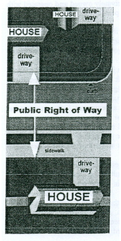
“Riparian.” Of, on, or relating to, the bank of a natural course of water.
“Riparian Buffer.” Riparian buffers are the areas of vegetation directly separating land from water and immediately adjacent land that is frequently inundated (the floodways of streams). Vegetation in riparian buffers typically consists of plants that either are emergent aquatic plants, or herbs, trees and shrubs that thrive in close proximity to water.
“Roof Line.” The lowest point of a roof that is closest to the ground.
"Salvage Material." Clean packing materials such as, but not limited to, cardboard boxes and paper, newspaper, plastic, rags, tires, scrap iron and other metals, glass, and similar materials, motor vehicles or parts thereof, used lumber, household garbage, inoperable machinery or appliances, and similar materials, which can be rejuvenated or returned for reconstitution. "Salvage/Scrap Yard." A facility, but not including a junkyard, recycling center, recycling plant, or scrap metal processing facility licensed under authority of ORC 4737.05 to 4737.12 or regulated under authority of the City, as defined by Section 713.01 of the City of Franklin Codified Ordinances, and not including motor vehicle salvage as defined by Section 715.01 of the City of Franklin Codified Ordinances, where salvage materials are bought, sold, exchanged, collected, salvaged, stored, baled, packed, disassembled, or handled.
“Satellite Parking.” Parking spaces located off-site of the building that it is designed to serve.
"Scrap Metal Processing Facility." An establishment having facilities for processing iron, steel, or nonferrous scrap and whose principal product is scrap iron and steel or nonferrous scrap for sale for remelting purposes.
“Sediment Basin.” A barrier, dam or other facility built to reduce the velocity of water in order to settle and retain sediment.
"Self-Service Storage Facility or Mini-Warehouse.” A facility consisting of a building or group of buildings, usually in a controlled-access compound, that may contain varying sizes of individual, self-contained, enclosed, compartmentalized and controlled-access stalls or lockers for the dead storage of customers' residential goods or wares, that are owned, leased or rented. Self-service storage facilities or miniwarehouses shall not include accessory automobiles rental or sales. Self-service storage facilities or miniwarehouses are not permitted under this UDO.
“Semi-Nudity, State of Semi-Nudity, Semi-Nude Condition or Semi-Nude.” Exposing to view, with less than a fully opaque covering, any portion of the female breast below the top of the areola or any portion of the buttocks. This definition shall include the entire lower portion of the female breast, but shall not include any portion of the cleavage of the female breast exhibited by a dress, blouse, shirt, leotard, bathing suit, or other clothing, provided that the areola is not exposed in whole or in part.
“Setback or Setback Line. ” The minimum distance that a building may be constructed from a lot line.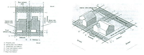
“Sex Store.” A business offering goods for sale or rent and that meet any of the following tests:
- More than 10 percent of the stock-in trade or inventory, or more than 10 percent of the gross public floor area of the business, consists of sexually-oriented novelties or toys; or
- It offers for sale items from any two of the following categories: adult entertainment, adult media, sexually-oriented novelties or toys, , lingerie, or apparel or other items marketed or presented in a context to suggest their use for sadomasochistic practices, and the combination of such items constitutes more than 15 percent of the stock-in-trade or inventory of the business or occupies more than 15 percent of the gross public floor area; or
- Which advertises or holds itself out in any forum as a sexually-oriented business by use of such terms as “sex toys, “marital aids,” “X-rated,” “XXX,” “adult,” “sex,” “nude,” or otherwise advertises or holds itself out as a sexually-oriented business.
- Sex Store shall not include any establishment which, as a substantial portion of its business, offers for sale or rental to individuals employed in the medical, legal or education professions anatomical models, including representations of human genital organs or female breasts, or other models, displays, and exhibits produced and marketed primarily for use in the practice of medicine or law or for use by an educational institution.
“Sexual Encounter Establishment.” A business or commercial enterprise that, as one of its principal business purposes, offers for any form of consideration:
- Physical contact in the form of wrestling or tumbling between persons of the opposite sex when one or more of the persons is nude or semi-nude; or
- Activities between male and female persons and/or persons of the same sex when one or more of the persons is nude or semi-nude; or
- A place where two or more persons may congregate, associate or consort for the purpose of engaging in specified sexual activities; or
- A place where two or more persons appear nude or semi-nude for the purpose of displaying their nude or semi-nude bodies for the their receipt of consideration or compensation in any type or form.
An establishment where a medical practitioner, psychologist, psychiatrist or similar professional person licensed by the State of Ohio engages in medically approved and recognized therapy including, but not limited to, massage therapy, as regulated pursuant to ORC 4731.15, is not a Sexual Encounter Establishment.
“Sexually-Oriented Business.” An adult arcade, adult bookstore, adult cabaret, adult entertainment establishment, adult media (video) store, adult motion picture theater, adult novelty store, adult theater, nude or semi-nude model studio, sex store, or sexual encounter establishment. “Sexually Oriented Business” does not include an adult motel, as defined above.
“Sexually-Oriented Novelties or Toys.” Instruments, devices or paraphernalia either designed as representations of human genital organs or female breasts, or designed or marketed primarily for use to stimulate or arouse human genital organs or female breasts or for sadomasochistic use or abuse of self or others.
“Short-Term Loan Lender.” Any business that is licensed, or is required to be licensed, under ORC 1321.35 to 1321.48 to make short-time loans. Short-term loan lender does not include any bank, savings and loan, credit union or similar financial institution doing business under authority granted by the Ohio Superintendent of Financial Institutions or by the equivalent regulatory authority of another state of the United States. Short-term load lenders are not permitted under this UDO.
“Side Lot Line.” See lot line, side.
“Side Yard.” See yard.
“Sight Distance.” The minimum extent of an unobstructed vision (on a horizontal plane) along a street from a point five feet above the centerline of a street.
“Sign.” Any display, figure, painting, drawing, placard, poster or other device placed on the ground or on any tree, wall, bush, rock, post, fence, building, structure or thing whatsoever, which is designed, intended or used to convey a message, advertise, inform or direct attention to a person, institution, organization, activity place, object or product. “Placed,” as used in this definition, includes erecting, constructing, posting, painting, printing, tracking, nailing, gluing, sticking, carving or other fastening, affixing or making visible in any manner whatsoever.
“Sign, Awning.” A sign that is mounted on or painted on an awning. “Sign, Banner.” A sign on a lightweight fabric, or similar non-rigid material that is attached by at least two corners of such sign, to a building or structure. Flags of any country, state, unit of local government, institution of higher learning, or similar institution area not considered to be banners. “Sign, Bench.” Any sign painted on, located on, or attached to any part of a surface of a bench, seat, or chair placed on or adjacent to a public roadway. “Sign, Billboard.” An off-premise, outdoor sign exceeding 50 square feet in area. Billboards are prohibited under this UDO. “Sign, Canopy.” A sign that is mounted on or painted on an attached canopy. “Sign, Construction.” A sign that is located on a lot that has active construction. “Sign, Direction.” A sign intending to direct the safe flow of vehicular and pedestrian traffic, including, but not limited to, “enter”, “exit”, “one way”, and “narrow signs.” “Sign, Electronic Message Center.” A sign that is capable of displaying words, symbols, figures, or images that can be electronically changed by remote or automatic means. May also be known as a variable message sign or a LED sign. “Sign, Flutter Flag.” A tall, narrow vertical flag that is designed to flutter in the wind and attract attention. “Sign, Governmental Flag.” Flags of any country, state, or unit of local government. “Sign, Ground.” A sign supported by one or more uprights, posts, or bases, in or upon the ground and not attached to any part of a building. "Sign, Human." A sign that is worn (including costumes) or held by a human for temporary commercial advertising or other promotional purposes. “Sign, Identification.” A sign indicating the identity or name, whether through logo, type, graphics or other symbols, address and activity occupying the building, store, service, or establishment. “Sign, Inflatable.” Any sign or device that is capable of being expanded. “Sign, Manual Changeable Copy.” A sign, or portion thereof, on which characters, letters, or illustrations are changed manually in the field without altering the face or surface of the sign, including without limitation, a reader board with changeable letters. “Sign, Marquee.” A sign attached to or constructed in a marquee. "Sign, Memorial." A sign designed, intended or used to preserve the memory of a person, place or event, including landmark plaques and historical plaques. “Sign, Menu Board.” Any signage pertaining to items, goods, or services offered by a drive-through business. “Sign, Mobile or Portable.” Any sign which is not permanently affixed to the ground or a building in accordance with the provisions of the building code of the city or any sign which is intended to be moveable or capable of being moved from place to place, whether or not wheels or other special supports are provided. Mobile or portable signs include but are not limited to “A” or “T” frame signs, swinger message board signs, windblown signs, trailer signs or any other type of sign which can be moved from one location to another. “Sign, Mural.” Any mosaic, painting, or graphic art or combination thereof which is professionally applied to a building. “Sign, Organizational Flag.” A flag for private or non-profit organizations. “Sign, Permanent.” A sign designed or intended to be used indefinitely, or used indefinitely without change in the same state or place, and includes canopy/marquee/awning signs, directional signs, electronic message centers, ground signs, manual changeable copy signs, menu boards, murals, projecting signs, residential development identification signs, wall signs, and window signs. “Sign, Pole.” A sign supported by one or more poles, posts or braces permanently mounted on or in the ground that exceeds six feet in height. Pole signs are not permitted under this UDO, except when approved in the Highway Sign Overlay District. “Sign, Public.” Signs required or authorized for a public purpose by any law, statute or ordinance, such signs to include traffic control devices provided that such signs contain no supplementary advertising, and any identification of display of any official court or public office notices thereof, or any flag, emblem, or insignia of a nation, political unit, school or religious group. “Sign, Projecting.” A sign affixed to any part of a building or structure which extends beyond the building or structure by no more than four feet. “Sign, Real Estate.” A sign announcing the sale, rental or lease of the lot where the sign is displayed, or announcing the sale, rental or lease of one or more structures, or a portion thereof, located on such lot, and indicating the owner, realty agent, telephone number or “open house” information. “Sign, Residential Development Identification.” A sign at the entrance of a residential neighborhood identifying the neighborhood. “Sign, Revolving.” A sign which in its entirety or in part moves in a revolving manner. “Sign, Roof.” A sign erected upon or above a roof or parapet wall of a building, which sign is wholly or partially supported by such building. Roof signs are prohibited under this UDO. “Sign, Snipe.” A sign that is posted, tacked, nailed, pasted, glued, or otherwise attached to trees, utility poles or structures, street lights fences, or any other object on public property or within the public right-of-way. “Sign, Streamer.” Any lightweight plastic, fabric or other material, whether or not containing a message of any kind, suspended from a rope, wire, string or cord, usually in series, designed to move in the wind. A streamer may have pennants and/or banners attached.
"Sign Structure." Any structure that supports, or is capable of supporting, any sign as defined in this UDO. A sign structure may be a single pole, or may or may not be an integral part of the building.
“Sign, Temporary.” A sign that is neither permanently anchored to the ground, nor permanently affixed to a structure, or mounted on a chassis, and/or is intended for a limited period of display.
“Sign, Vehicle.” A sign that is attached to or painted on a vehicle that is parked on or adjacent to any property, the principal purpose of which is to attract attention to a product sold or business located on the property.
“Sign, Wall.” A sign attached to a building face, with the exposed face thereof in a plane parallel to the plane of the wall. Wall signs include painted murals, messages, graphics and other designs painted along with any letters or numerals mounted on buildings and any extensions thereon.
“Sign, Window.” A sign, graphic, poster, symbol or other identification or information about the use or premises which is physically affixed to or painted on the glass or other structural component of the window or a sign, graphic, poster, symbols, or other identification or information about the use or premises erected on the inside of the building within two feet of the window and intended to be viewed through the window from the exterior of the premises.
“Site Development Plan.” The written document or set of plans that meet the requirements of this UDO, provide information on the location of the area proposed for development and the site in relation to its general surroundings, and existing characteristics of the site, including limits of earth disturbing activities.
“Site Plan.” A plan showing uses and structures proposed for a parcel of land, as required by the regulations involved. Includes lot lines, streets, building sites, reserved open space, buildings, major landscape features - both natural and man-made - and, depending on the requirements, the location of proposed utility lines.
“Sketch Plan.” An informal plan or sketch showing the existing features of a site and its surroundings and the general layout of a proposed minor subdivision.
“Sleeping Area.” Floor space provided in a building designed, intended or used primarily as a place to sleep. “Sleeping area” includes all bedroom space and all other areas where beds are permanently kept.
“Small Loan Lender.” Any business that is licensed, or is required to be licensed, under ORC 1321.01 to 1321.19 to make small loans. Small Loan Lender does not include any bank, savings and loan, credit union or similar financial institution doing business under authority granted by the Ohio Superintendent of Financial Institutions or by the equivalent regulatory authority of another state of the United States. Small loan lenders are not permitted under this UDO.
“Small Loan Operations.” Small Loan Operations shall include alternative finance service providers, check-cashing businesses, credit service organizations, mortgage loan lenders, short-term loan lenders, and small loan lenders. Small Loan Operations shall not include any bank, savings and loan, credit union or similar financial institution doing business under authority granted by the Ohio Superintendent of Financial Institutions or by the equivalent regulatory authority of another state of the United States. Small loan operations are not permitted under this UDO.
"Smoking and Hookah Bars." An establishment in which tobacco products are sold for use or consumption on the premises to persons that are over 18 years old as provided by state law. This use includes but is not limited to establishments referred to as smoking, cigar, hookah, or tobacco bars or lounges. Smoking and hookah bars are not permitted under this UDO.
"Solar Panels, Roof-Mounted." Panels installed on the roof of a building to allow for the conversion of solar energy to electrical current.
"Special Event." A gathering of human beings, lasting for a designated period of time, designed to celebrate, honor, discuss, sell, teach, encourage, observe, or influence human endeavors. Examples include, but is not limited to, parades, markets, festivals, or car shows.
“Special Flood Hazard Area.” Also known as “Areas of Special Flood Hazard,” it is the land in the floodplain subject to a one percent or greater chance of FLOODING in any given year. Special flood hazard areas are designated by the Federal Emergency Management Agency on flood insurance rate maps, flood insurance studies and flood boundary and floodway maps as Zones A, AE, AH, AO, A1 30, and A99. Special flood hazard areas may also refer to areas that are flood prone and designated from other federal state or local sources of data including but not limited to historical flood information reflecting high water marks, previous flood inundation areas, and flood prone soils associated with a watercourse.
“Specified Anatomical Areas.” This term is used to describe:
- The human male genitals in a discernibly turgid state, even if completely and opaquely covered; or
- Less than completely and opaquely covered human genitals, pubic region, buttocks, including the cleft, anus, or female breast below a point immediately above the top of the areola.
“Specified Criminal Activity.” Any of the following offenses: Prostitution or promoting prostitution; soliciting; loitering to engage in solicitation; sexual performance by a child; public lewdness; indecent exposure; indecency with a child; sexual assault; molestation of a child; or any similar offenses to those described above under the criminal or penal laws of any local jurisdiction, state, or country for which less than two years have elapsed since the date of conviction or the date of release from confinement imposed for the conviction, whichever is the later date, if the conviction is of a misdemeanor offense; or less than five years have elapsed since the date of conviction or the date of release from confinement for the conviction, whichever is the later date, if the conviction is of a felony offense. The fact that a conviction is being appealed shall not prevent such conviction from constituting a specified criminal activity as defined in this section.
“Specified Sexual Activities.” Means any of the following:
- The fondling or other erotic touching of human genitals, pubic region, buttocks, anus, or female breasts;
- Sex acts, normal or perverted, actual or simulated, including intercourse, oral copulation, masturbation, or sodomy; or
- Excretory functions as a part of or in connection with any of the activities set forth in (a) or (b), above.
“Start of Construction.” The date the building permit was issued, provided the actual start of construction, repair, reconstruction, rehabilitation, addition, placement, or other improvement was within 180 days of the permit date. The actual start means either the first placement of permanent construction of a structure on a site, such as the pouring of slab or footings, the installation of piles, the construction of columns, or any work beyond the stage of excavation; or the placement of a manufactured home on a foundation. Permanent construction does not include land preparation, such as clearing, grading, and filling; nor does it include the installation of STREETS and/or walkways; nor does it include excavation for a basement, footings, piers, or foundations or the erection of temporary forms; nor does it include the installation on the property of accessory structures, such as detached garages or sheds not occupied as dwelling units or not part of the main structure. For a substantial improvement, the actual start of construction means the first alteration of any wall, ceiling, floor, or other structural part of a building, whether or not that alteration affects the external dimensions of a building.
“Stock-In Trade or Inventory.” The individual items offered for sale or rental in the area of an establishment open to the public.
“Stop-Work Order.” An order issued that requires that all work on the site must cease, except work associated with bringing the site into compliance with the approved SWP3, site development plan or construction plans.
"Storage Shed." See Storage Structure.
"Storage Structure." An accessory structure that is not classified for human habitation or occupancy and is intended to be used to store personal property.
“Story.” The part of the building included between the surface of one floor and the surface of the next floor, or if there is no floor above, then the ceiling next above. If the floor level directly above a basement is more than six feet above grade, such basement shall be considered a story.
“Story, Half.” An uppermost story lying under a sloping roof having an area of at least 200 square feet with a clear height of seven feet, six inches. For the purposes of this UDO, the usable floor area is only that area having at least four feet of clearance height between the floor and the ceiling.
“Storm Frequency.” The average period of time, in years, within which a storm of a given duration and intensity can be expected to be equaled or exceeded.
“Stormwater Management Plan (SMP).” The written document meeting the requirements of this UDO regulation that sets forth the plans and practices to be used to minimize storm water runoff from a site and to safely convey or temporarily store and release post-development storm water runoff at an allowable rate to minimize flooding and erosion.
“Storm Water Pollution Prevention Plan (SWP3).” The document required by the Ohio EPA for compliance with its NPDES Construction Activity General Permit #OHC000002. The requirements of the SWP3 are required as part of the local jurisdiction's Stormwater Management Plan, as described above, and in this UDO.
“Street.” An improved public way or right-of-way dedicated to public use, which provides for vehicular and pedestrian access to abutting properties.
- Alley: Any dedicated public way affording a secondary means of access to abutting property, either to the back or side of properties abutting on another street, and not intended for general traffic circulation.
- Collector Street: A street, whether within a residential, industrial, commercial or other type of development, which primarily carries traffic from minor/local streets to major streets.
- Expressways: A thoroughfare that possesses extra-wide rights-of-way carrying high traffic volumes of unobstructed, limited access vehicular movement.
- Major Street: An arterial street intended for large volumes of through traffic and to carry cross-town traffic from several neighborhoods, thereby servicing collector streets. Such streets are intended for carrying heavy loads and large volumes of traffic, for both the immediate City area and the region beyond. Any street with a width, existing or proposed, of 80 feet shall be considered a major thoroughfare.
- Marginal Access Street: A minor street that is parallel and adjacent to a major street or thoroughfare, and which provides access to abutting properties and protection from major or collector streets.
- Minor Street: A local street that primarily provides access to residential or other abutting property.
“Street Line.” The edge of the pavement along the front of the property.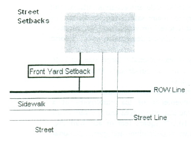
“Street Setback Measurements.” All buildings and structures shall hereafter be constructed in accordance with the required front yard setbacks in the district in which it is to be located, measured from the dedicated right-of-way line or the street line, whichever is greater, on expressways, major streets, collector streets, marginal access streets, minor streets and alleys.
“Structural Controls.” Any human-made facility, structure, or device that is constructed to provide temporary storage and/or treatment of storm water runoff. Examples include retention and detention basins, rock-check dams, swales, and constructed wetlands.
“Structure.” Anything constructed or erected. Its use requires location on the ground or attachment to something having location on the ground including, but not limited to a walled or roofed building, manufactured home, or gas or liquid storage tank that is principally above ground.
“Subdivider.” Any person, partnership, corporation, association or other legal entity that creates or proposes to create a subdivision, all or a portion of which will be located within the City (See also developer).
“Subdivision, Major.” A platting of land for the purposes of development and transfer of ownership. A major subdivision is any subdivision that does not meet the requirements of a minor subdivision. It requires approval of a preliminary plat by the Planning Commission, approval of a final plat by the Planning Commission, acceptance by Council, and recording of the final plat prior to the transfer of land (See also major subdivision).
“Subdivision, Minor.” A division of a parcel of land that is approved by the City Engineer and does not require a plat or the combination or replatting of two or more parcels into a single lot that is approved by the City Engineer (See minor subdivision).
“Subdivision Regulations.” Chapter 1111, including any amendments thereto, contained in this UDO.
“Substantial Damage.” Damage, of any origin, sustained by a structure whereby the cost of restoring the structure to its “before-damaged” condition would equal or exceed 50 percent of the market value of the structure before the damage occurred.
“Substantial Improvement.” Any reconstruction, rehabilitation, addition, or other improvement of a structure, the cost of which equals or exceeds 50 percent of the market value of the structure before the start of construction of the improvement. This term includes structures, which have incurred substantial damage, regardless of the actual repair work performed. The term does not, however, include:
- Any project for improvement of a structure to correct existing violations of state or local health, sanitary, or safety code specifications which have been identified by the local code enforcement official and which are the minimum necessary to assure safe living conditions; or
- Any alteration of a historic structure, provided that the alteration would not preclude the structure's continued designation as a historic structure.
“Superblock.” A residential block of exceptionally large size, in both dimensions, with access to interior lots by culs-de-sac or loop streets and providing one or more common open spaces.
“Support Commercial Uses.” Support retail and personal service uses conducted primarily for the convenience of the employees of a permitted use, if such use serves the immediate area and the sum of all such uses occupy no more than 10,000 square feet of any building. Examples of such uses include retail, athletic clubs and gyms, personal service shops (barber, dry cleaner, salon, etc.), business services (printing, photocopying, mailing and packaging, etc.), child care center, cafeteria or restaurant, financial institution, medical clinic.
“Surveyor.” A person licensed by the State of Ohio and registered as a professional surveyor under ORC 4733.
“Swale.” A low-lying stretch of vegetated land that gathers and carries surface water.
"Taproom." A place in which alcoholic drinks are available and are generally served on tap.
"Tattoo Parlor/Body-Piercing Studio." An establishment whose principal business activity is the practice of placing designs, letters, figures, symbols, or other marks upon or under the skin of any person, using ink or other substances that result in the permanent coloration of the skin by means of the use of needles or other instruments designed to contact or puncture the skin or the creation of an opening in the body of a person for the purpose of inserting jewelry or other decoration. Tattoo Parlors/Body-Piercing Studios are not permitted under this UDO.
"Temporary Structure." A structure without any foundation or footing and removed when the designated time period, activity, or use for which the temporary structure was erected has ceased.
“Temporary Vegetation.” Short-term vegetative cover such as oats, rye, or wheat, used to stabilize the soil surface until final grading and installation of permanent vegetation.
“Tent.” Any structure used for living or sleeping purposes, or for sheltering a public gathering, constructed wholly or in part from canvas, tarpaulin or other similar materials. It includes shelter provided for circuses, carnivals, sideshows, revival meetings, camp meetings and all similar meetings or exhibitions in temporary structures.
“Time and Temperature Display.” A cabinet containing illuminated numerals flashing alternately to show the time and temperature.
“Through Lot.” See Lot.
“Total Area of a Sign.” “Sign area” shall be measured as outlined in Section 1111.08(e) of this UDO.
“Tower.” Any structure that is designed and constructed primarily for the purpose of supporting one or more antennas for telephone, radio and similar communication purposes, including self-supporting lattice, towers, guyed-towers, or monopoles; the term includes radio and television transmission towers, microwave towers, common-carrier towers, wireless telecommunications towers, alternative tower structures, and the like; the term includes the structure and any support thereto.
“Transportation or Communication Utility.” A structure or facility used by a public utility or quasi-public utility to store, distribute or generate electricity, gas or telecommunications and related equipment, or to pump or chemically treat water. This use does not include storage or treatment of sewage, solid waste or hazardous waste.
“Travel-Time Contour.” A locus of points from which water takes an equal amount of time to reach a given destination such as a well or well field.
“Treatment Space.” Floor space provided in a building that is designed, intended or used primarily for the treatment of human and/or animal illness.
“Truck Stop/Truck Service or Gasoline Center.” A business that provides the sale and storage of fuel, overnight or hourly parking, and/or other special services catering to commercial motor vehicles, specifically Semi-Trucks and Semi- Trailers. Truck Stops/Truck Service or Gasoline Centers are prohibited under this UDO.
"Truck Terminal.” Any lot or part thereof, any part of land, or any structure which is used for the temporary parking of trucks during loading or unloading between trips; for purposes of servicing or repairing such trucks within enclosed structures; and for necessary warehouse space for storage of transitory freight; and upon which the storage of freight is incidental to the primary function of motor freight shipment.
“UDO.” See Unified Development Ordinance.
“Underground Storage Tank.” Underground storage tank shall have the same meaning as in ORC 3737.87.
“Unified Development Ordinance.” The combining of development regulations and procedures, including zoning and subdivision regulations, sign and floodplain regulations, administrative and hearing procedures, etc. into one unified code and ordinance in the City of Franklin Unified Development Ordinance.
“Use.” The purpose for which land or a building is arranged, designed or intended, or for which land or a building is or may be occupied.
"Vape, Tobacco, or Hookah Stores." Any store, stand, booth, or concession that devotes 30 percent or more of its display floor area to tobacco products, or to the display and sale of tobacco, vapor products, or electronic smoking devices to purchases for consumption or use. This classification of use does not include medical marijuana uses which are prohibited in the City of Franklin per the City of Franklin Ordinance Section 513.16.
“Variance.” A grant of relief from the standards of these regulations.
“Variety Store (or Point Price Retailer)” A commercial establishment that sells a wide range of inexpensive household goods, often selling or advertising all goods at a single price, which is reflected in the name of the establishment. Variety Stores (or Point Price Retailers) are not permitted under this UDO.
“Vehicle (Motor-Driven).” Any automobile, truck, motorcycle, trailer, truck camper, recreational vehicle, bus or boat (See also Motor Vehicle).
“Vehicle, Inoperable.” Any motor vehicle that does not have a current registration and/or cannot move under its own power.
“Vehicle Impound Lot.” A business that engages in impounding or storing, usually temporarily, of legally impounded vehicles, whether publicly or privately impounded, or abandoned vehicles.Vehicle Wrecking.” The dismantling or wrecking of used vehicles or trailers, or the storage, sale or dumping of dismantled, partially dismantled, obsolete, wrecked or inoperable vehicles or their parts; excepting that vehicle impound lots are not included in this definition. Vehicle Wrecking is not permitted under this UDO.
“Veterinary Services.” A place used for grooming and/or for the care, diagnosis and treatment of sick, ailing, infirm or injured animals and those that are in need of medical or surgical attention, and may include overnight accommodations on the premises for the treatment, observation or recuperation of such animals. Such use may also include boarding that is incidental to the primary activity. Such uses include animal hospitals/clinics, veterinarian offices and grooming services.
“Video Booth.” Any private or semi private booth or any viewing room of less than 150 square feet of floor space or area to which the public may gain admittance, wherein a still or motion picture machine, projector, video monitor, or similar equipment is available for the purpose of showing still or motion pictures, videos, or similar images or photographic reproductions to five or fewer individuals at any one time.
“Viewing Booth.” Live Viewing Booth or Video Booth.
“Viewshed.” The area surrounding a wireless telecommunications facility or antenna support structure, within which the facility or structure is visible from off-site.
“Violation.” The failure of a structure or other development to be fully compliant with the regulations contained in this UDO.
"Warehouse, Primary Use." Storage of raw materials, parts, or finished manufactured goods associated before their export or distribution for sale. The warehouse is staffed, and goods leave and enter the warehouse at a minimum on a weekly basis.
"Warehouse, Secondary Use." A secondary use to an industrial or commercial use where raw materials, parts, or finished manufactured goods may be stored before their export or distribution for sale. Such storage must be within a building.
“Watercourse.” Any natural or artificial waterway (including, but not limited to, streams, rivers, creeks, ditches, channels, canals, conduits, culverts, drains, waterways, gullies, ravines, or washes) in which waters flow in a definite direction or course either continuously or intermittently and including any area adjacent thereto which is subject to inundation by reason of overflow of flood water.
“Watershed.” A locus of points from which water takes an equal amount of time to reach a given destination such as a well or well field.
“Well Field.” Means a tract of land that contains a number of wells for supplying water.
“Wireless Telecommunications Facilities.” Any cables, wires, lines, wave guides, antennas, microwave dishes and any other equipment or facilities associated with the transmission or reception of communications as authorized by the FCC which a PERSON seeks to locate or has installed upon a tower or antenna support structure; however, the term Wireless Telecommunications Facilities shall not include:
- Any satellite earth station antenna two meters in diameter or less which are located in an area zoned industrial or commercial;
- Any satellite earth station antenna one meter or less in diameter, regardless of zoning category; or
- Antennas used by amateur radio operators.
“Yard.” The open space on the same lot with a main building unoccupied and unobstructed from the ground upward except as otherwise provided in this UDO, and a defined herein:
- Front yard: An open space extending the full width of the LOT, the depth of which is the minimum horizontal distance between the front lot line and the nearest point of the main building. There shall be a front yard on each street side of a corner lot.
- Rear yard: An open space extending the full width of the lot, the depth of which is the minimum horizontal distance between the rear lot line and the nearest point of the main building. In the case of a corner lot, the rear yard shall be opposite of the front of the building.
- Side yard: An open space between a main building and the side lot line, extending from the front yard to the rear yard, the width of which is the horizontal distance from the nearest point of the side lot line to the nearest point of the main building.
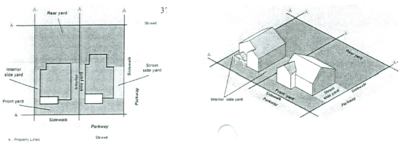
“Zoning District.” A portion of the incorporated area of the City within which certain regulations and requirements, or various combinations thereof, apply under the provisions of this UDO.
“Zoning Map.” The official map showing the zoning district within the incorporated areas of the City and which is a part of the UDO.
“Zoning Official.” The person holding the title of Zoning Official of the City of Franklin, or his designee.
(Ord. 2009-11. Passed 7-6-09; Ord. 2011-06. Passed 4-4-11; Ord. 2011-07. Passed 4-4-11; Ord. 2012-26. Passed 12-3-12; Ord. 2013-09. Passed 6-17-13; Ord. 2014-01. Passed 3-17-14; Ord. 2014-17. Passed 1-5-15; Ord. 2015-11. Passed 7-6-15; Ord. 2015-15. Passed 11-2-15; Ord. 2017-01. Passed 2-6-17.)
Amended by Ord. 2018-08 on 5/21/2018
Amended by Ord. 2018-19 on 11/5/2018
Amended by Ord. 2021-04 on 4/5/2021
Amended by Ord. 2021-06 on 5/3/2021
Amended by Ord. 2021-29 on 12/6/2021
Amended by Ord. 2022-12 on 5/2/2022
Amended by Ord. 2023-01 on 3/7/2023
Amended by Ord. 2023-20 on 10/9/2023
Amended by Ord. 24-02 on 3/18/2024
Amended by Ord. 2024-34 on 1/7/2025
Amended by Ord. 2025-03 on 2/3/2025
Amended by Ord. 2025-07 on 3/17/2025
Amended by Ord. 2025-13 on 6/16/2025
Amended by Ord. 2025-26 on 11/10/2025
Amended by Ord. 2025-29 on 1/5/2026
1105.02 Technical Review Committee
1105.03 Zoning Official
1105.04 City Engineer
1105.05 Historic District Review Board
1105.06 Planning Commission
1105.07 Appeals Board
1105.08 Council
1105.09 Fees
1105.10 Right Of Entry
1105.11 Revocation Of Zoning Certificate
1105.12 Enforcement And Penalties
CROSS REFERENCES
Administrative board; powers and duties - see Ohio R.C. 713.11
Violation of zoning ordinance may be enjoined - see Ohio R.C. 713.13
- The formulation, administration and/or enforcement of this UDO are hereby vested in the following Officers and Boards of the City:
- The Technical Review Committee;
- The Zoning Official;
- The City Engineer;
- The Planning Commission;
- The Appeals Board; and
- City Council.
- All departments, officials and public employees of the City vested with the duty or authority to issue permits, certificates or licenses shall conform to the provisions of this UDO and shall issue no permit, certificate or license for any use, building, structure or purpose if the same is in conflict with the provisions of this UDO. Any permits, certificates or licenses that are not issued in conformity with this UDO shall be deemed null and void.
(Ord. 2009-11. Passed 7-6-09.)
- Role: The TRC is the technical review body composed of City staff responsible for the initial review of applications submitted to the City under the UDO.
- Powers and Duties: The members of the TRC shall review all applications forwarded to it by the Zoning Official and the City Engineer, which are to be considered by the Planning Commission, the Appeals Board, , and/or City Council.
- Membership: The TRC may be comprised of the City Manager, the City Engineer, the Law Director, the Zoning Official, the Public Works Director, the Fire Chief and the Police Chief. Additional persons possessing specific expertise in a matter relating to a given application or issue may be added to the TRC, as determined by the Zoning Official.
- Meetings: The Zoning Official will serve as the Chairperson to the TRC and schedule meetings. The City Engineer will report on the TRC's review of pertinent applications to the Planning Commission. The Zoning Official will report on the TRC's review of all pertinent applications to the Appeals Board. In his discretion, the Zoning Official may invite the applicant to attend the TRC meeting. The TRC meeting for an application may occur before the staff report is prepared for that application.
(Ord. 2009-11. Passed 7-6-09.)
- Authority: The City Manager shall appoint an administrative officer, named the Zoning Official, who shall have the primary responsibility for administering and enforcing this UDO.
- Duties and Responsibilities: It shall be the duty of the Zoning Official to:
- Accessory Uses and Structures: Issue permits for accessory uses, and accessory structures in accordance with this UDO, and enforce the accessory structure and use regulations and standards of this UDO;
- Certificates of Zoning Compliance: Issue Certificates of Zoning Compliance, in accordance with this UDO, and maintain a complete record of all such certificates issued. A Certificate of Zoning Compliance, or written notification and explanation of refusal of an application for such certificate, shall be issued to the applicant within sixty (60) days of submission of the application. Failure to notify the applicant of refusal within such period shall entitle the applicant to submit his or her request to the Appeals Board;
- Signs: Issue permits for signs in accordance with the sign regulations of this UDO, except as otherwise provided therein, and enforce the sign regulations of this UDO;
- Minor Site Plans: Review minor site plans for their conformity with this UDO and approve such site plans as submitted, disapprove such site plans, or approve with modifications;
- Temporary Use Permits: Issue temporary use permits in accordance with this UDO;
- Enforcement: Enforce the provisions of this UDO;
- Interpretation: Interpret the text and Official Zoning District Maps of this UDO;
- Appeals and Variances: Act upon all appeals and variance applications within sixty (60) days of their date of filing by forwarding the same to the TRC, and upon final review by the TRC, to the Appeals Board;
- Standards and Regulations: Review all development and redevelopment applications for conformance with the parking standards, sign standards, industrial performance standards and supplementary regulations of this UDO, as applicable;
- Advise Appeals Board: Advise the Appeals Board of all matters pertaining to issues that it needs to act upon and provide all documents, maps and any other related information that the Zoning Official deems necessary or that the Appeals Board requests;
- Violations: Determine whether or not various uses of land within the area of the City are in compliance with this UDO, and, where violations exist, notify in writing the person(s) responsible, specify the exact nature of the violation and maintain a complete record of such notices; and
- Records: Maintain and keep the permanent records required by this UDO, including, but not limited to, the Official Zoning District Map(s), zoning certificates, inspections and all official zoning actions of Council, the Planning Commission, the Appeals Board and the public.
(Ord. 2009-11. Passed 7-6-09.)
- Duties and Responsibilities: It shall be the duty of the City Engineer to:
- Floodplain Development Permits: Issue Floodplain Development Permits in accordance with the provisions of the Floodplain Overlay District of this UDO;
- Landscaping Plans: Review all landscape plans to assure conformance with the landscaping standards of this UDO;
- Stormwater Management Plans: Review all stormwater management plans to assure conformance with the stormwater and drainage standards of this UDO;
- Zoning Amendments and Conditional Use Permits: Act upon all Zoning Amendment and Conditional Use Permit applications within thirty- (30) days of their date of filing by forwarding the same to the TRC, and upon final review by the TRC, to the Planning Commission;
- Development Regulations: Review all Site Plans to assure conformance with the development regulations of this UDO;
- Subdivisions:
- Major: Review Major Subdivisions to assure conformance with the Development Requirements and Standards of the UDO;
- Minor: Review and approve applications for minor subdivisions.
- PUDs: Review all PUD and PRCD applications to assure conformance with the regulations of the UDO;
- Stormwater Design Requirements: Review all applications proposing any type of new development or redevelopment to assure conformance with the stormwater design standards, floodplain overlay standards, and well field protection standards of this UDO, as applicable;
- Telecommunication Overlay District: Review all special permit applications for telecommunication towers to assure conformance with the telecommunication overlay standards of this UDO;
- Advise Planning Commission and Council: Advise the Planning Commission and the Council on all matters pertaining to issues that they need to act upon and provide all documents, maps and any other related information that the City Engineer deems necessary or that the Planning Commission or Council requests.
(Ord. 2009-11. Passed 7-6-09; Ord. 2010-22. Passed 12-6-10.)
- Authority: The Planning Commission shall be constituted and carry out its duties and responsibilities as prescribed in this UDO and in accordance with the City of Franklin Charter.
- Duties and Responsibilities:
- Zoning Amendments: Review and make recommendations to Council on all applications proposing amendments to this UDO, including proposed text amendments or amendments to the Official Zoning District Map(s), which recommendations shall be compatible with the Comprehensive Development Plan and this UDO;
- PUDs: Review Development Plans for the PUD and PRCD Overlay Districts and make recommendations regarding such plans to Council, in accordance with the Comprehensive Development Plan and this UDO;
- Subdivisions: Review applications, Plats and Site Plans for major subdivisions and make recommendations on approval of major subdivisions to Council, in accordance with the Comprehensive Development Plan and this UDO;
- Conditional Use Permits: The Planning Commission may authorize the issuance of Conditional Use Permits to petitioners who specifically meet the requirements and standards for such a permit listed in this UDO, including Conditional Use Permits for Home Occupations and Conditional Use Permits for Sexually Oriented Businesses;
- Well Field Protection Overlay District: The Planning Commission may authorize uses within the WFP Overlay District in accordance with the Comprehensive Development Plan and this UDO;
- Telecommunications Overlay District: The Planning Commission may approve a Special Permit for certain uses within the TOD to petitioners who specifically meet the requirements and standards for such permit, in accordance with the Comprehensive Development Plan and this UDO;
- Major Site Plan: The Planning Commission shall review and may approve all uses requiring the submittal of a Major Site Plan under this UDO; and
- Interpretation of Zoning Text and Map(s): The Planning Commission has the power to decide any question involving the interpretation of the text and Map(s) of this UDO, including determinations of similar uses for uses not specifically mentioned in this UDO.
(Ord. 2009-11. Passed 7-6-09; Ord. 2010-22. Passed 12-6-10.)
- Authority: The Appeal Board shall be constituted and carry out its duties and responsibilities as prescribed in this UDO and in accordance with the City of Franklin Charter.
- Duties and Responsibilities:
- Administrative Appeals: The Appeals Board shall hear and decide appeals where it is alleged there is error in any order, requirement, decision or determination made by the Zoning Official or City Engineer in the administration and enforcement of the provisions of this UDO;
- Variances: The Appeals Board may authorize, upon appeal, by reasons of exceptional narrowness, narrowness, shape, topographic conditions or other extraordinary situation or condition of a lot, a variance from strict application of the provisions of this UDO, to relieve exceptional difficulties or undue hardship, provided that such relief can be granted without substantial detriment to the public good and does not substantially impair the intent of this UDO; and
- Changes in Nonconforming Uses: The Appeals Board may authorize the reasonable extension of a nonconforming use or the substitution of a nonconforming use of a building or land with a similar use, when such extension or substitution will not be detrimental to the neighborhood;
- Decision of Board: The Appeals Board may by super-majority vote and in conformity with this section, reverse or affirm, wholly or partly, or modify, the order, requirement, decision or determination appealed from and may make such order, requirement, decision or determination as ought to be made, and to that end may have all powers of the officer from whom the appeal is taken.
(Ord. 2009-11. Passed 7-6-09.)
- Authority: Council may carry out its duties and responsibilities relative to this UDO in accordance with the City Charter.
- Duties and Responsibilities:
- Act upon suggested amendments to the text or Official Zoning District Map(s) of this UDO following receipt of recommendations from the Planning Commission;
- Act upon suggested development plans for the Overlay Districts following receipt of recommendations of the Planning Commission;
- Appoint the Planning Commission and the Appeals Board as prescribed by the City Charter.
and Hear
(Ord. 2009-11. Passed 7-6-09.)
The Zoning Official shall collect fees, according to the following schedule, from all applicants requesting the following:
| Accessory Use and Structure Permits | |
| Accessory Structures/Sheds | $50.00 |
| Antenna and Antenna Towers | $50.00 |
| Decks, Patios, Porches & Balconies | $50.00 |
| Dish-Type Satellite Signal Receiving Antennas | $50.00 |
| Fences & Walls | $50.00 |
| Garages/Carports/Barns | |
| Gazebos, Trellises & Other Open-Sided Structures | $50.00 |
| Swimming Pools & Hot Tubs | $50.00 |
| Above Ground | $50.00 |
| In-Ground | $50.00 |
| Appeals | $200.00 |
| Certificates of Zoning Compliance | $50.00 |
| Conditional Use Permits | $500.00 |
| Construction Plans | $300.00 |
| Final Plat Amendments | $150.00 |
| Floodplain Overlay District Permit | $150.00 |
| Major Site Plan | $500.00* |
| Minor Site Plan | $200.00 |
| Major Subdivision (per Preliminary and per Final Plat) | $500.00 + $10.00 per lot |
| Minor Subdivision | $150.00 |
| Nonconforming Use - Substitution or Extension | $150.000 |
| PUD Preliminary Development Plan | $1,000.00* + $10.00 per lot or unit for residential
uses and $50 per acre for nonresidential uses |
| PUD Final Development Plan | $500.00* |
| Planned Residential Conservation District (PRCD) | |
| PRCD Preliminary Development Plan | $1,000.00 +
$10.00 per lot or unit for residential uses |
| PRCD Final Development Plan | $500.00 |
| $500.00 | |
| Sign Permits | |
| - New Sign | $100.00 for 1st sign |
| Each Additional Sign | $25.00 |
| - Replacement of existing sign face (for sign that already has a sign permit) | $50.00 |
| Similar Uses, Determination of | $100.00 |
| Stormwater Management Plan and Site Development Plan Review | $300.00* |
| Temporary Certificates | $50.00 |
| Telecommunications Overlay District Special Permit | $200.00* |
| Variances | $200.00 |
| Well Field Protection Overlay District Permit | $200.00* |
When the applicant submits an application for more than one permit and/or approval, and the applications are substantially the same, the City Manager, in his sole discretion, may waive all or part of any fee herein required.
*Any additional costs above the established application fee shall be borne by the applicant at a rate equal to the actual costs to the City.
(Ord. 2009-11. Passed 7-6-09; Ord. 2014-07. Passed 7-7-14.)
Amended by Ord. 2022-12 on 5/2/2022
Amended by Ord. 2023-07 on 4/3/2023
Amended by Ord. 2024-35 on 1/7/2025
The Zoning Official, Safety Director or authorized representative is hereby authorized to enter any building, dwelling, structure or premises at reasonable times, and upon reasonable notice to the owner, in order to assure compliance with the provisions of this UDO; however such right shall be subject to constitutional restrictions on unreasonable searches and seizures. If entry is refused or not obtained, the Zoning Official, Safety Director or other authorized representative is hereby authorized to pursue recourse as provided by law including, but not limited to, seeking an administrative search warrant.
(Ord. 2009-11. Passed 7-6-09.)
Any zoning certificate issued upon a knowingly made material misrepresentation shall be void, and such false statement shall be deemed a violation of this UDO. Zoning certificates issued on the basis of plans and applications approved by the Zoning Official authorize only the use and arrangement set forth in such approved plans and applications, and construction at variance with that use authorized shall be deemed a violation of this UDO. Whenever the fact of such unauthorized variance in plans or false statement is established to the satisfaction of the Zoning Official, the zoning certificate shall be revoked by notice in writing that will be delivered to the holder of the void certificate. Any person who shall proceed thereafter with such work or use without having obtained a new zoning certificate, in accordance with this UDO, shall be deemed guilty of a separate violation thereof.
(Ord. 2009-11. Passed 7-6-09.)
- Violations and Equitable Remedies: No person shall erect, construct or alter any building or structure, or use any land, in violation of this UDO. If any building is or is proposed to be located, erected, constructed, reconstructed, enlarged, changed, maintained or used, or any land is or is proposed to be used in violation of this UDO or any amendment or supplement thereto, the City or any adjacent or neighboring property owner who would be especially damaged by such violation, in addition to other remedies provided by law, may institute an action in injunction, mandamus, abatement or any other appropriate action, actions or proceedings by notice in writing to be delivered upon such premises to the owner of the premises, and by any other required notice, to prevent, enjoin, abate or remove such unlawful location, erection, construction, reconstruction, enlargement, change, maintenance or use.
- Enforcement by Zoning Official: It shall be the duty of the Zoning Official to enforce this UDO in accordance with these administrative provisions. All departments, officials and employees of the City of Franklin, shall comply with the provisions of this UDO, and shall issue no permit, license, or registration for any use, building or purpose in conflict with the provisions of this UDO. Any permit, license, or registration, issued in conflict with the provisions of this UDO shall be voidable by the Zoning Official. The duties imposed on the Zoning Official shall not constitute a limitation on the power of other enforcement officers of this City to make arrest or to institute prosecutions for violations of this UDO.
- Violations and Penalties:
- It shall be unlawful to locate, erect, construct, reconstruct, enlarge, change, maintain, or use any building or land in violation of any of the provisions of this UDO, or any amendment or supplement thereto adopted by the Council of the City of Franklin. Any person, firm, corporation, or other legal entity violating any of the provisions of this UDO, or any amendment or supplement, shall be guilty of a minor misdemeanor. Upon conviction, the person, firm, corporation, or other legal entity shall be fined not less than seventy-five dollars ($75.00) nor more than one hundred fifty dollars ($150.00).
- Any person, firm, corporation, or other legal entity that is convicted of violating any of the provisions of this UDO, having been previously convicted of violating any of the provisions of this UDO, or any amendment or supplement within two years of the offense charged, shall be guilty of a first degree misdemeanor and fined not less than five hundred dollars ($500.00) nor more than one thousand dollars ($1,000.00).
- Each and every day during which such illegal location, erection, construction, reconstruction, enlargement, change, maintenance or use continues, shall be deemed to be a separate offense.
- Remedies: In case any building is or is proposed to be used in violation of this UDO, or any amendment or supplement, the City or any adjacent or neighboring property owner who would be specifically damaged by such violation may institute appropriate action or proceedings to prevent such unlawful location, erection, construction, reconstruction, alteration, conversion, maintenance or use. The action could be to restrain, correct or abate such violation; to prevent the occupancy of said building structure or land; or to prevent any illegal act, conduct, business or use in or about such premises.
- Rights Reserved to the City: The City shall have the right to deny approval of any plats, development plans, or construction plans that do not comply with the provisions, requirements and/or standards of this UDO.
- Exemptions: Government entities carrying out a governmental function, activity, or implementation of essential services may be exempt in whole or in part from this UDO at the discretion of Council.
(Ord. 2009-11. Passed 7-6-09.)
1107.02 Official Zoning Map
1107.03 Interpretation Of District Boundaries
1107.04 Permitted Use Table
1107.05 General Use Standards
1107.06 Agricultural Use Standards
1107.07 Residential Use Standards
1107.08 Public And Institutional Use Standards
1107.09 Commercial Use Standards
1107.10 Industrial Use Standards
1107.11 Accessory Use Standards
1107.12 Temporary Use Standards
1107.13 A-1 And PAR Dimensional Standards
1107.14 Residential Districts Dimensional Standards
1107.15 Commercial District Dimensional Standards
1107.16 Downtown Districts Dimensional And Design Standards
1107.17 Office Districts Dimensional Standards
1107.18 Industrial Districts Dimensional Standards
1107.19 Measurements, Computations, And Exceptions
- Zoning Districts Established: The City is divided into the following zoning districts, which shall be governed by all the use and area requirements of this Ordinance. The following table lists each district along with its appropriate symbol:
TABLE 1107.01-1: Zoning DistrictsAbbreviation District Name Section Agricultural District A-1 Agricultural District 1107.01(b)(1)(A) Parks and Recreation District PAR Parks and Recreation District 1107.01(b)(2)(A) Residential Districts R-1 One-Family Residential District 1107.01(b)(3)(A) R-2 Metropolitan Residential District 1107.01(b)(3)(B) R-3 Central Residential District 1107.01(b)(3)(C) R-4 Multi-Family Residential District 1107.01(b)(3)(D) Commercial Districts C-1 General Commercial Districts 1107.01(b)(4)(A) C-2 Community Commercial District 1107.01(b)(4)(B) Downtown Districts DC-1 Downtown Core District 1107.01(b)(5)(A) MU-1 Mixed Use District 1107.01(b)(5)(B) RMU Riverfront Mixed Use District 1107.01(b)(5)(C) CV-1 Civic District 1107.01(b)(5)(D) TN-1 Transitional Neighborhood District 1107.01(b)(5)(E) TN-2 Transitional Mixed Use District 1107.01(b)(5)(F) Office Districts O-1 Office and Institutional District 1107.01(b)(6)(A) O-RP Research Park District 1107.01(b)(6)(B) O-S Office Service District 1107.01(b)(6)(C) Industrial Districts I-1 Light Industrial District 1107.1(b)(7)(A) I-2 General Industrial District 1107.1(b)(7)(B) Overlay Districts TOD Telecommunications Overlay District 1107.1(b)(8)(A) FOD Floodplain Overlay District 1107.1(b)(8)(B) WFP Well Field Protection Overlay District 1107.1(b)(8)(C) PUD Planned Unit Development Overlay District 1107.1(b)(8)(D) PRCDP Planned Residential Conservation Overlay District 1107.1(b)(8)(E) HSOD Highway Sign Overlay District 1107.1(b)(8)(F) - Zoning District Purpose Statements
- Agricultural District: The agricultural district within the UDO is the (A-1) Agricultural District. The agricultural zoning district and its regulations are hereby established to achieve, among others, the following purposes:
- A-1 Agricultural District: The intent of the A-1 Agricultural District is to provide space in the City for agriculture and related uses and to allow for undeveloped open space. Land best suited for this district includes those sections of the City that are prime farmland in outlying areas and/or land that has significant natural features, such as wetlands, forest, hillsides, and other open space that should be preserved.
- Parks and Recreation District: The parks and recreation district within the UDO is the (PAR) Parks and Recreation District. The parks and recreation district and its regulations are hereby established to achieve, among others, the following purposes:
- PAR Parks and Recreation District: The Parks and Recreation District is a special purpose zoning district intended to designate and protect lands dedicated to the public or open to the public use for no fee or for private parks and event centers. The purpose of this District is to preserve and enhance such major open space and public and private recreational, educational cultural, and aesthetic areas by protecting the natural amenities they possess.
- Residential Districts: The residential districts within the UDO include the (R-1) One-Family Residential District, (R-2) Metropolitan Residential District, (R-3) Central Residential District, and (R-4) Multi-Family Residential District. The residential districts and their regulations are hereby established to achieve, among others, the following purposes:
- R-1 One-Family Residential District: The intent of the One-Family Residential District is to provide space in the City for low-density, single-family residential uses, and to provide for additional uses that serve the residential neighborhood as conditional uses. The R-1 District is further divided into two subcategories:
- R-1A: Estate Residential District: The intent of the Estate Residential District is to provide spaces for the lowest density, single-family residential uses, with an average density of three dwelling units or less for every one acre of land.
- R-1B: Suburban Residential District: The intent of the Suburban Residential District is to provide space for low density, single-family residential uses, with an average density of four dwelling units or less for every one acre of land.
- R-2 Metropolitan Residential District: The intent of the Metropolitan Residential District is to provide space in the City for moderate-density, single-family residential uses in urban areas with complete municipal services, and to provide for additional uses that serve the residential neighborhood as conditional uses.
- R-3 Central Residential District: The intent of the Central Residential District is to recognize the existence of older residential areas of the City where homes have been built on small lots and where conservation of the existing housing stock should be encouraged. The R-3 Central Residential District allows for existing moderate-density housing and new single-family development.
- R-4 Multi-Family Residential District: The intent of the Multi-Family Residential District is to provide for mixed housing types at medium to high density in urban areas with complete municipal services. The R-4 District should generally be located to provide a smooth transition between residential areas and more intense uses.
- R-1 One-Family Residential District: The intent of the One-Family Residential District is to provide space in the City for low-density, single-family residential uses, and to provide for additional uses that serve the residential neighborhood as conditional uses. The R-1 District is further divided into two subcategories:
- Commercial Districts: The commercial districts within the UDO include the (C-1) General Commercial District and the (C-2) Community Commercial District. The commercial districts and their regulations are hereby established to achieve, among others, the following purposes:
- C-1 General Commercial District: The intent of the General Commercial District is to provide for general commercial activity, including a wide range of goods and services that will serve the region. This district is intended to be concentrated around transportation notes (such as the intersections of primary arterial streets).
- C-2 Community Commercial District: The intent of the Community Commercial District is to provide for low-intensity retail uses providing primarily goods and personal services for residential areas with good access to primary and secondary arterial streets.
- Downtown Districts: The downtown districts within the UDO include the (DC-1) Downtown Core District, (MU-1) Mixed Use District, (RMU) Riverfront Mixed Use District, (CV-1) Civic District, (TN-1) Transitional Neighborhood District, and (TN-2) Transitional Mixed Use District. The downtown districts and their regulations are hereby established to achieve, among others, the following purposes:
- DC-1 Downtown Core: The intent of the Downtown Core District is to promote a mixed use traditional downtown center that is a destination within the region for culture, dining, shopping, and gathering.
- MU-1 Mixed Use District: The intent of the Mixed Use District is to identify areas within Downtown Franklin for key mixed-use developments that include a diverse mix of uses at an intensity to catalyze development throughout Downtown Franklin.
- RMU Riverfront Mixed Use District: The intent of the Riverfront Mixed Use District is to establish a multi-use destination along the Great Miami River, that attracts people for commercial, recreation, or leisure experiences.
- CV-1 Civic District: The intent of the Civic District is to identify areas within Downtown Franklin for civic destinations that provide a variety of key services to Franklin residents and the region.
- TN-1 Transitional Neighborhood District: The intent of the Transitional Neighborhood District is to provide a variety of residential development types, styles, and price points that cater to existing Franklin residents, while also attracting new residents into the City.
- TN-2 Transitional Mixed Use District: The intent of the Transitional Mixed use District is to provide a variety of residential development types, styles, and price points while also encouraging the development or redevelopment of neighborhood scale commercial uses that provide goods and personal services to the surrounding area.
- Office Districts: The office districts within the UDO include the (O-1) Office and Institutional District, (O-RP) Research Park District, and (O-S) Office Service District. The office districts and their regulations are hereby established to achieve, among others, the following purposes:
- O-1 Office and Institutional District: The intent of the Office and Institutional District is to encourage the orderly development of office and institutional uses within the same district with consideration of the similar characteristics these uses share, including location, parking requirements, traffic, and accessibility. Development standards of this district are intended to provide compatibility with and protection to surrounding residential properties.
- O-RP Research Park District: The intent of the Research Park District is to provide for and encourage the orderly development of a variety of light manufacturing, technology-based industries, research and development and office uses that are established in a campus-like setting, with landscaping and architectural amenities that create a sense of place and esthetically attractive urban development. It is intended that this District will provide for the grouping and clustering of professional offices, non-hazardous industrial uses, research and development uses, and high technology manufacturing that interact together in terms of functions, location, activities and appearance. Development standards for this District are intended to provide compatibility with and protection to surrounding residential and commercial properties, as well as assuring that such facilities are developed in a clustered campus or park-like setting that emphasizes natural characteristics, landscaping and pedestrian access.
- O-S Office Service District: The intent of the Office Service District is to provide for business and professional offices/buildings and related commercial uses and services that will serve the employees and clients of such businesses, as well as the surrounding area. This District is intended to be concentrated around transportation nodes, such as highway interchanges and major intersections.
- Industrial Districts: The industrial districts within the UDO include the (I-1) Light Industrial District and the (I-2) General Industrial District. pose: The industrial districts and their regulations are hereby established to achieve, among others, the following purposes:
- I-1 Light Industrial District: The intent of the 1-1 Light Industrial District is to provide for industrial and office uses that are not of an intensity to produce objectionable impacts on adjacent development. This District should be located within areas of the City with suitable access to transportation routes and necessary utilities.
- I-2 General Industrial District: The intent of the 1-2 General Industrial District is to provide for all industrial uses, including those high-intensity uses that create noticeable impacts on the surrounding area. All uses, however, will be required to operate without causing a risk to the health and welfare of the inhabitants of the City. This District is intended to be located within areas of the City that have suitable access to transportation routes and necessary utilities and that are away from residential uses.
- Overlay Districts. The overlay districts within the UDO include the (TOD) Telecommunications Overlay District, (FOP) Floodplain Overlay District, (WFP) Well Field Protection Overlay District, (PUD) Planned Unit Development Overlay District, (PRCD) Planned Residential Conservation Overlay District, and (HSOD) Highway Sign Overlay District. The overlay districts and their regulations are hereby established to achieve, among others, the following purposes:
- TOD Telecommunications Overlay District: The purpose of this Overlay District is to regulate the placement, construction and modification of Towers and Wireless Telecommunications Facilities in order to protect the health, safety and welfare of the public, while at the same time not unreasonably interfering with the development of the competitive wireless telecommunications marketplace in the City. The Telecommunications Overlay District is outlined in Chapter 1109.
- FOP Floodplain Overlay District: The Floodplain Overlay District is composed of lands that are subject to periodic flooding. It is intended to preserve the existing flood plains, so as to allow the waterways a place to overflow at high water levels and thus assist in protecting other areas not now subject to flooding. In this District, only those uses that are temporary or seasonal in nature or that would not be extensively damaged by flooding are permitted. The Floodplain Overlay District is outlined in Chapter 1109.
- WFP Well Field Protection Overlay District: It is the intent of the Well Field Protection Overlay District to safeguard the health, safety and welfare of the customers of protected public water supplies and to protect the community's potable water supply against contamination by regulating land use and the storage, handling, use and/or production of regulated substances as defined below. The land within the overlay district is that land in the City of Franklin that lies within a one (1) year travel time contour adjacent to existing and proposed public wells of a protected public water supply. The Well Field Protection Overlay District is outlined in Chapter 1109.
- PUD Planned Unit Development Overlay District: This District is intended to encourage and coordinate planned development, with benefits for both the Developer and the Community. The Planned Unit Development Overlay District is outlined in Chapter 1109.
- PRCD Planned Residential Conservation District: It is the intent of the Planned Residential Conservation District to allow residential development while protecting the community's natural resources and real quality. The Planned Residential Conservation District is outlined in Chapter 1109.
- HSOD Highway Sign Overlay District: The primary objective of the Highway Sign Overlay District (HSOD) is to recognize that there exist special circumstances for businesses which border Interstate 75 whereby signage and placement of signage that would not normally be permitted in the underlying zoning district should be permitted in this Overlay District. The Highway Sign Overlay District is outlined in Chapter 1109.
(Ord. 2009-12. Passed 7-6-09; Ord. 2010-05. Passed 3-1-10; Ord. 2014-01. Passed 3-17-14.) - Agricultural District: The agricultural district within the UDO is the (A-1) Agricultural District. The agricultural zoning district and its regulations are hereby established to achieve, among others, the following purposes:
- Official Zoning Map Adopted: All land in the municipality is placed into zoning districts as shown on the Official Zoning Map that is hereby adopted and declared to be part of the UDO. Said Map was approved by Ordinance 2010-09, adopted on April 5, 2010, and became effective on May 5, 2010, and as subsequently amended.
- Final Authority: The Official Zoning Map, as amended from time to time, shall complement appropriate legislation as the final authority for the current zoning district status of land under the jurisdiction of the UDO.
- Land Not Otherwise Designated: All land under the UDO and not designated or otherwise included within another zoning district map shall be included in the R-I One-Family Residential District.
- Identification of the Official Zoning District Map: The Official Zoning Map, with any amendments made thereon, shall be identified by the signatures of the Mayor and all members of Council under the following words: Official Zoning District Map, Franklin, Ohio. Adopted by the City Council, Franklin, Ohio.
(Ord. 2009-12. Passed 7-6-09; Ord. 2013-18. Passed 11-4-13; Ord. 2014-1. Passed 3-17-14.)
Amended by Ord. 2022-01 on 3/8/2022
Amended by Ord. 2023-20 on 10/9/2023
Amended by Ord. 24-02 on 3/18/2024
Amended by Ord. 2025-04 on 2/3/2025
- Legend and Use of Color or Patterns: There shall be provided on the Official Zoning Map a legend, which shall list the name and symbol for each zoning district. In lieu of a symbol, a color or black and white pattern may be used on the Official Zoning Map to identify each zoning district as indicated in the legend.
- Interpretation of Zoning District Boundaries: The boundaries of the zoning districts are shown upon the Official Zoning Map. The Official Zoning Map and all notations, references, and other information are a part of the UDO. A certified copy of the Official Zoning Map shall be kept on file with the City's Zoning and Building Department.
- Rules for Determination: When uncertainty exists with respect to the boundaries of zoning districts as shown on the Official Zoning Map, the following rules shall apply:
- Along a Street or Other Right-of-Way: Where zoning district boundary lines are indicated as approximately following a center line of a street or highway, alley, railroad easement, or other right-of-way, or a river, creek, or other watercourse, such centerline shall be the zoning district boundary.
- Along a Property Line: Where zoning district boundary lines are indicated as approximately following a lot line, such lot line shall be the zoning district boundary.
- Parallel to Right-of-Way or Property Line: Where zoning district boundary lines are indicated as approximately being parallel to a centerline or a property line and, in the absence of a specified dimension on the Official Zoning Map.
- Actual Conflict with Map: When the actual street or lot layout existing on the ground is in conflict with that shown on the Official Zoning Map, the party alleging that such conflict exists shall furnish an actual survey for interpretation by the Zoning Official.
- Right-of-Way Vacation: Whenever any street, alley or other public way is vacated by official action of Council, the zoning district adjoining each side of such street, alley or public way shall be automatically extended to the center of such vacation, and all area included in the right-of way.
(Ord. 2009-12. Passed 7-6-09; Ord. 2010-05. Passed 3-1-10; Ord. 2011-06. Passed 4-4-11; Ord. 2011-07. Passed 4-4-11; Ord. 2013-09. Passed 6-17-13; Ord. 2013-18. Passed 11-4-13; Ord. 2014-01, Passed 3-17-14; Ord. 2014-17. Passed 1-5-15.)
Amended by Ord. 2021-06 on 5/3/2021
Amended by Ord. 2021-29 on 12/6/2021
Amended by Ord. 2023-01 on 3/7/2023
Amended by Ord. 2023-20 on 10/9/2023
Amended by Ord. 24-02 on 3/18/2024
Amended by Ord. 2025-04 on 2/3/2025
- Regulation of the Use and Development of Land and Structures: These regulations are established and adopted governing the use and physical development of land and/or structures.
- Rules of Application: These regulations shall be interpreted and enforced according to the following rules:
- Identification of Uses: Listed uses are to be defined by their customary name or identification, except where they are specially defined or limited in this UDO.
- Permitted Uses: Only a use designated as a permitted use shall be allowed as a matter of right in a zoning district and any use not so designated shall be prohibited except, when in character with the zoning district, such other additional uses may be added to the permitted uses of the zoning district by an amendment to this UDO.
- Conditional Uses: A use designated as a conditional use may be allowed in a zoning district when such conditional use, its location, extent and method of development will not substantially alter the character of the vicinity or unduly interfere with the use of adjacent lots in the manner prescribed tor the zoning district. To this end the Planning Commission may, in addition to the development standards for the zoning district, set forth such additional requirements as will, in its judgment, render the conditional use compatible with the existing and future use of adjacent lots and the vicinity.
- Accessory Uses: A use designated as an accessory use shall be permitted in a zoning district when such use is subordinate in area, extent, and purpose to the principal use and is located on the same lot and in the same zoning district as the principal use.
- Prohibited Uses: If a use is not listed on Table 1107.04-1 or Table 1107.04-2, then it shall also be considered prohibited, unless approved specifically through the similar use determination as established in section 1115.09(f): Determination of Similar Uses.
- Additional Standards: The section reference contained in the "REF" column on Table 1107.04-1 and Table 1107.04-2 are references to additional standards are requirements that apply to uses listed in the respective row. Standards referenced in the table apply to all the zoning districts in which the use is permitted or conditionally permitted, unless otherwise expressly stated. In the table a "PS" represents a permitted use that has additional standards, and a "CS" represents a conditional use that has additional standards.
- Development Standards: The development standards shall be the minimum required for development in a zoning district unless otherwise stated. If the development standards are in conflict with the requirements of any other lawfully adopted rules, regulations or laws, the more restrictive or higher standards shall govern.
TABLE 1107.04-1: Agricultural, Residential, and Parks and Recreation Districts Use TableAgricultural Uses A-1 PAR R-1 R-2 R-3 R-4 REF Agriculture P PS 1107.06(a) Residential Uses A-1 PAR R-1 R-2 R-3 R-4 REF Dwelling, Four Family P Dwelling, Live/Work CS 1107.07(a) Dwelling, Multi-Family 5+ Units P Dwelling, Row House CS 1107.07(b) Dwelling, Single-Family P P P P P Dwelling, Three Family P P Dwelling, Two Family C P P Elderly Housing CS CS 1107.07(d) Residential Living Facility, Large CS 1107.07(e) Residential Living Facility, Medium CS CS 1107.07(e) Residential Living Facility, Small PS PS PS PS PS 1107.07(e) Residential Treatment Facility, Large CS 1107.07(e) Residential Treatment Facility, Medium CS CS 1107.07(e) Residential Treatment Facility, Small PS PS PS PS PS 1107.07(e) Public/Institutional Uses A-1 PAR R-1 R-2 R-3 R-4 REF Cemeteries, Mortuaries CS 1107.08(b) Educational Facilities (Pre-K thru 12th Grade) CS CS 1107.08(c) Essential Services PS PS PS PS PS PS 1107.08(d) Government Facility P P P P P P Public Parks, Open Spaces, Recreation, and Preserves, Outdoor PS PS PS PS PS PS 1107.08(e) Religious and Cultural Facilities CS CS CS CS CS 1107.08(g) Secondary Education, Colleges, and Universities CS CS 1107.08(c) Commercial Uses A-1 PAR R-1 R-2 R-3 R-4 REF Assisted Living and Skilled Nursing Care CS 1107.09(b) Retreat Center P Bed and Breakfast CS CS CS CS CS 1107.09(h) Commercial Recreation/Fitness, Indoor CS PS CS CS CS CS 1107.09(k) Commercial Recreation/Fitness, Outdoor CS PS CS CS CS CS 1107.09(k) Farm Market P Landing Field CS 1107.09(o) Accessory Uses A-1 PAR R-1 R-2 R-3 R-4 REF Accessory Structures PS PS PS PS PS PS 1107.11 Accessory Uses PS PS PS PS PS PS 1107.11 Antennas and Towers PS PS PS PS PS 1107.11(b) Day Care Home, Type A CS CS CS CS CS 1107.11(d) Day Care Home, Type B PS PS PS PS PS 1107.11(e) Decks, Patios, Porches, and Balconies PS PS PS PS PS PS 1107.11(f) Dwelling, Accessory Unit CS CS CS CS CS 1107.11(h) Electric Vehicle (EV) Charging Stations, Accessory PS PS PS PS PS PS 1107.11(i) Fences and Walls PS PS PS PS PS PS 1107.11(j) Garages and Carports, Detached PS PS PS PS PS PS 1107.11(k) Home Occupation, Type A PS PS PS PS PS 1107.11(l) Home Occupation, Type B CS CS CS CS CS 1107.11(l) Open-Sided Structure PS PS PS PS PS PS 1107.11(m) Parking Area, Accessory P P P P P P Parking of Recreational Vehicles and Watercraft PS PS PS PS PS 1107.11(s) Playground Equipment PS PS PS PS PS PS 1107.11(u) Solar Panels, Roof Mounted PS PS PS PS PS PS 1107.11(v) Storage Structure PS PS PS PS PS PS 1107.11(w) Swimming Pools and Hot Tubs, Private PS PS PS PS PS PS 1107.11(x) Temporary Uses A-1 PAR R-1 R-2 R-3 R-4 REF Construction Trailer PS PS PS PS PS PS 1107.12(a) Farm Market, Temporary P Festivals and Circuses PS PS PS PS PS PS 1107.12(b) Mobile Uses PS PS 1107.12(c) Model Home PS PS PS PS 1107.12(d) Residential Sales PS PS PS PS PS 1107.12(e) Residential Storage Units (PODs) PS PS PS PS PS 1107.12(f) Seasonal Sales PS 1107.12(g) Temporary Structures P P P P P P P= Permitted Use, PS= Permitted Use with Use Specific Standards, C= Conditional Use, CS= Conditional Use with Specific Standards
TABLE 1107.04-2: Nonresidential Districts Use TableResidential Uses C-1 C-2 DC-1 MU-1 RMU CV-1 TN-1 TN-2 O-1 O-RP O-S I-1 I-2 REF Dwelling, Four Family CS P P Dwelling, Live/Work CS CS PS PS PS 1107.07(a) Dwelling, Multi-Family 5+ Units C C C C C Dwelling, Row House CS CS CS CS PS PS 1107.07(b) Dwelling, Single Family P P Dwelling, Three Family C P P Dwelling, Two Family P P Dwelling, Upper Floor CS CS PS PS PS PS PS 1107.07(c) Elderly Housing CS CS 1107.07(d) Residential Treatment Facility, Medium CS CS 1107.07(e) Residential Treatment Facility, Small PS PS 1107.07(e) Residential Treatment Facility, Medium CS CS 1107.07(e) Residential Treatment Facility, Small PS PS 1107.07(e) Public/Institutional Uses C-1 C-2 DC-1 MU-1 RMU CV-1 TN-1 TN-2 O-1 O-RP O-S I-1 I-2 REF Alcohol and Drug Addiction Treatment Facilities CS CS 1107.08(a) Cemeteries and Mortuaries PS 1107.08(b) Educational Facilities (Pre-K thru 12th Grade) CS CS CS CS 1107.08(c) Essential Services PS PS PS PS PS PS PS PS PS PS PS PS PS 1107.08(d) Government Facility P P P P P P P P P P P P P Public Parks, Open Spaces, Recreation, and Preserves, Outdoor PS PS PS PS PS PS PS CS CS 1107.08(e) Public Plazas, Gathering, and Eating Areas P P P P P P Public Recreation and Event Space, Indoor CS PS PS 1107.08(f) Religious and Cultural Facilities CS CS CS CS CS CS CS CS CS 1107.08(g) Secondary Education, Colleges, and Universities CS CS CS CS CS 1107.08(c) Transportation or Communication Utility P P Commercial Uses C-1 C-2 DC-1 MU-1 RMU CV-1 TN-1 TN-2 O-1 O-RP O-S I-1 I-2 REF Alcohol Production and Sales, Large PS CS 1107.09(a) Alcohol Production and Sales, Small PS PS PS PS PS 1107.09(a) Artist Studio and Gallery P P P P P P Assisted Living and Skilled Nursing Care PS PS CS 1107.09(b) Automobile Fueling/ Charging Stations CS CS 1107.09(c) Automobile Sales/Rental CS 1107.09(d) Automobile Service/Repair, Heavy CS 1107.09(e) Automobile Service/Repair, Light CS 1107.09(f) Automobile Washing Facility C Bar, Lounge, Tavern PS PS PS PS PS 1107.09(g) Bed and Breakfast CS CS CS CS CS 1107.09(h) Business Retail PS PS CS CS PS 1107.09(u) Business Service CS CS PS PS 1107.09(i) Clubs, Private or Membership P P Commercial Entertainment PS CS CS CS CS CS 1107.09(j) Commercial Recreation/ Fitness, Indoor CS CS CS CS CS CS 1107.09(k) Commercial Recreation/ Fitness, Outdoor CS CS CS CS CS 1107.09(k) Commercial Training P P C C C Day Care Center CS CS CS CS CS CS CS CS 1107.09(l) Event Venue, Indoor or Outdoor CS CS CS 1107.09(m) Financial Institution, General P P Food Service/Catering P P Hospitals P Hotels PS CS CS CS CS CS CS PS 1107.09(n) Information Technology/Data Center P P Makerspace P C P P P P P Medical Center/Clinic PS PS CS CS CS PS 1107.09(p) Medical Office P P C P C C C C Mixed Use PS PS PS PS PS PS PS 1107.09(q) Office P P P P P P C C P P P Office, Campus P C P P Office, Co-Working P C P C C Personal Service PS PS CS CS PS 1107.09(r) Restaurant, Quick Service PS CS 1107.09(s) Restaurant, Standard PS PS PS PS PS PS PS 1107.09(t) Retail, Convenience PS CS 1107.09(u) Retail, Food/Beverage Related PS PS PS PS PS PS 1107.09(u) Retail, General PS PS PS PS PS PS 1107.09(u) Retail, Large Format CS Retail, Services C P Sexually Oriented Businesses CS 1107.09(w) Veterinary Services CS CS 1107.09(x) Industrial Uses C-1 C-2 DC-1 MU-1 RMU CV-1 TN-1 TN-2 O-1 O-RP O-S I-1 I-2 REF Distribution Center CS PS 1107.10(c) Environmental Sciences P P P Fulfillment Center PS PS 1107.10(d) Industrial, Artisan P C P P Industrial, Heavy P Industrial, Light P P Large Equipment Retail, Rental, and Repair PS PCS 1107.10(e) Material Sciences P P P Research and Development Facility P P P Warehouse, Primary Use CS 1107.10(f) Warehouse, Secondary Use PS PS 1107.10(g) Accessory Uses C-1 C-2 DC-1 MU-1 RMU CV-1 TN-1 TN-2 O-1 O-RP O-S I-1 I-2 REF Accessory Structures PS PS PS PS PS PS PS PS PS PS PS PS PS 1107.11 Accessory Uses PS PS PS PS PS PS PS PS PS PS PS PS PS 1107.11 Antennas and Towers PS PS PS PS PS PS PS 1107.11(b) Automated Teller Machine (ATM), Outdoor PS PS 1107.11(c) Day Care Home, Type A CS CS CS CS CS 1107.11(d) Day Care Home, Type B PS PS PS PS PS 1107.11(e) Decks, Patios, Porches, and Balconies PS PS PS PS PS PS PS PS 1107.11(f) Drive-Thru for Retail or Restaurant Use PS CS 1107.11(g) Dwelling, Accessory Unit CS CS 1107.11(h) Electric Vehicle (EV) Charging Stations PS PS PS PS PS PS PS PS PS PS PS PS PS 1107.11(i) Fences and Walls PS PS PS PS PS PS PS PS PS PS PS PS PS 1107.11(j) Garages and Carports, Detached PS PS 1107.11(k) Home Occupation, Type A PS PS PS PS PS 1107.11(l) Home Occupation, Type B CS CS CS CS CS 1107.11(l) Open-Sided Structures PS PS PS PS PS 1107.11(m) Outdoor Dining PS PS PS PS PS PS 1107.11(n) Outdoor Retail and Display PS PS PS PS PS PS 1107.11(o) Outdoor Storage PS PS PS PS 1107.11(p) Parking Area P P PS PS PS PS PS PS P P P P P 1107.11(q) Parking Garage P P PS PS PS PS PS PS P P 1107.11(q) Parking of Recreational Vehicles and Watercraft PS PS 1107.11(s) Pick-Up Window for Retail or Restaurant Use PS PS PS PS PS PS 1107.11(t) Playground Equipment PS PS 1107.11(u) Solar Panels, Roof-Mounted PS PS PS PS PS PS PS PS PS PS PS PS PS 1107.11(v) Storage Structure PS PS PS PS PS PS PS PS PS PS PS PS PS 1107.11(w) Swimming Pools and Hot Tubs, Private PS PS PS 1107.11(x) Temporary Uses C-1 C-2 DC-1 MU-1 RMU CV-1 TN-1 TN-2 O-1 O-RP O-S I-1 I-2 REF Construction Trailer PS PS PS PS PS PS PS PS PS PS PS PS PS 1107.12(a) Farm Market P P P P Festivals and Circuses PS PS PS PS PS PS PS PS PS PS PS PS PS 1107.12(b) Mobile Uses PS PS PS PS PS PS PS PS PS PS PS PS
PS1107.12(c) Model Home PS PS PS PS 1107.12 (d) Residential Sales PS PS PS PS 1107.12(e) Residential Storage Units (PODs) PS PS PS PS 1107.12(f) Seasonal Sales PS PS PS PS PS PS 1107.12(g) Special Event PS PS PS PS PS PS 1107.12(h) Temporary Structure P P P P P P P P P P P P P P= Permitted Use, PS= Permitted Use with Use Specific Standards, C= Conditional Use, CS= Conditional Use with Specific Standards
Amended by Ord. 2025-04 on 2/3/2025
Amended by Ord. 2025-26 on 11/10/2025
Amended by Ord. 2025-29 on 1/5/2026
- External Effects: No land, building or structure in any district shall be used or occupied in any manner so as to create any dangerous, injurious, noxious or otherwise objectionable fire, explosion or other hazard; noise, brilliant light or vibration; smoke, dust, fumes, odor or other form of air pollution; heat, cold or dampness; electrical or electronic disturbances; nuclear radiation; or any other condition, substance or element which is dangerous, injurious, noxious or otherwise objectionable to any person or property outside of the premises on which such building, structure or use is located. Such uses, when lawfully permitted under the provisions of this UDO, shall be operated in a manner so as to ensure that the property rights of all other parcels of land will not be adversely affected to the extent of reducing the enjoyment of property rights thereon.
- Removal of Soil, Sand, or Other Materials: The use of land for the removal of topsoil, sand and other materials from the land, other than materials from basement excavations, is not permitted in any district, except under a temporary permit from the Appeals Board. This permit may be denied or issued in appropriate cases after the filing of an application accompanied by a suitable agreement or bond that such removal will not cause stagnant water to collect and will not leave the surface of the land, at the expiration of such permit, in an unstable condition or unfit for the growing of turf or for other land uses permitted in the district in which such removal occurs.
- Agriculture: Agricultural uses in the R-1A Estate Residential District are subject to the following regulations:
- Purpose: It is recognized that the R-1A Estate Residential District, due to its larger lot size and location of the district, by provide adequate area for some limited agricultural uses. This use shall be for the purpose of allowing limited agricultural uses in the R-1A, Estate Residential District on lots of two acres or more.
- Agricultural uses shall be limited to:
- The raising for private use or sale of fruit, vegetables, or nursery stock;
- The keeping of sheep, goats, hogs, or other small farm animals;
- The keeping of poultry/domestic fowl, such as chickens, turkeys, ducks, and geese; and
- The keeping of bovine and/or equine animals.
- Standards for the Raising for Sale of Fruit, Vegetables, or Nursery Stock: The raising of produce or nursery stock for the purposes of sale shall require 10 acres.
- Standards for the Keeping of Sheep, Goats, Hogs, or Other Small Farm Animals:
- One sheep, goat, hog or other small farm animal may be kept per 1.5 acres of land, but in no case shall the total number of animals exceed four such animals regardless of the size of the lot.
- The structure containing the farm animal shall be located not less than 100 feet from any residence on an adjoining parcel.
- No storage of manure or odor or dust-producing substance shall be permitted.
- Land shall be fenced so as to securely confine such animals. Such fencing shall not be located closer to any public right-of-way or private street than the minimum setback in the district and shall not be located closer than 15 feet from any other residential property line.
- No farm animals shall be kept on a vacant lot unless the owner of such vacant lot lives on a lot contiguous to said vacant lot.
- The use shall comply in all respects with any and all applicable state and federal regulations.
- Standards for the Keeping of Poultry/Domestic Fowl:
- Roosters shall be limited to one per five acres.
- Chickens, turkeys, ducks and/or geese shall be limited to five per acre.
- Regardless of acreage, in no case shall the total number of poultry/domestic fowl exceed 12 such animals. Land acreage shall be measured exclusive of road or street right-of-way.
- The structure containing the poultry/domestic fowl shall be located not less than 100 feet from any residence on an adjoining parcel.
- No storage of droppings or odor or dust-producing substances shall be permitted.
- The animals shall be securely confined by fencing, which shall not be located closer to any public right-of-way or private street than the minimum setback in the district and shall not be located closer than 15 feet from any other residential property line.
- No poultry/domestic fowl shall be kept on a vacant lot unless the owner of such vacant lot lives on a lot contiguous to said vacant lot.
- The use shall comply in all respects with any and all applicable state and federal regulations.
- Standards for the Keeping of Bovine and/or Equine Animals:
- The minimum area of any lot on which bovine and/or equine animals may be kept shall be five acres, exclusive of road or street right-of-way; but in no case shall the total number of animals exceed three such animals over six months of age and three foals up to six months in age, regardless of the size of the lot.
- The structure containing the animal shall be located not less than 100 feet from any residence on an adjoining parcel.
- No storage of manure or odor or dust-producing substance shall be permitted.
- Land shall be fenced so as to securely confine such animals. Such fencing shall not be located closer to any public right-of-way or private street than the minimum setback in the district and shall not be located closer than 15 feet from any other residential property line.
- No such animals shall be kept on a vacant lot unless the owner of such vacant lot lives on a lot contiguous to said vacant lot.
- The use shall comply in all respects with any and all applicable state and federal regulations.
- Dwelling, Live/Work: Live/work dwellings shall have a ground floor utilized by a permitted non-residential use in addition to the review standards in Section 1113.01.
- Dwelling, Row House: Row Houses are subject to the following regulations in addition to the review standards in Section 1113.01:
- If the row house dwellings have front garage access, then such development shall have a minimum front yard setback of 20 feet from the property line. Row house dwellings are encouraged to be set close to the street with rear parking and garage access.
- Row house dwellings may be built to the side property line when there is a shared wall along the property line. The ends of each grouping of row house dwellings shall meet the required side yard setback in the district in which they are located, and a minimum of 10 feet shall be maintained between each separated group of row houses.
- For districts in which row houses are a conditional use, the following standards shall apply:
- The exterior of the proposed use shall be compatible with the residential character of the neighborhood.
- If patios are to be provided, they shall be shown on the construction plans and may be enclosed with a solid wall or fence. The space between patio fences or walls shall not be less than five feet, unless otherwise approved by the Planning Commission.
- Dwelling, Upper Floor: Upper floor dwellings are subject to the following regulations. Upper floor dwellings that require conditional use approval shall also be subject to the review standards in Section 1113.01:
- Dwelling units may not be located on the ground floor of the building.
- Separate direct access to a ground floor entrance must be provided.
- The proposed dwelling units must meet local fire safety requirements for the proposed use and level of occupancy.
- All upper floor dwelling units shall be provided parking spaces in accordance with the multi-family parking requirements contained in Section 1111.07; excepting that parking may be provided by a satellite parking lot located within 500 feet of the property.
- Elderly Housing: Elderly housing is subject to the following regulations in addition to the review standards in Section 1113.01:
- The minimum floor area for dwelling units shall be 800 square feet.
- The proposed use shall be appropriately located and shall be in convenient walking distance of shopping and community facilities wherever possible.
- Each dwelling unit shall be occupied in accordance with the “housing for older persons” exemption under the federal Fair Housing Amendments Act. The applicant shall submit documentation showing that the proposed development will be restricted to elderly housing, in the form of deed restrictions on each lot, or in the case of a condominium development, by the articles of incorporation and the Homeowner's Association bylaws.
- No dwelling unit in the development shall include more than two bedrooms.
- Planning Commission may modify the dimensional requirements of the underlying zoning district for the proposed use, where it finds such modification to be in the best interest of allowing an appropriate Elderly Housing Development that will be harmonious with the surrounding neighborhood.
- If patios are to be provided, they shall be shown on the construction plans, and may be enclosed with a solid wall or fence. The space between patio fences or walls shall not be less than five feet unless otherwise approved by Planning Commission.
- Residential Living Facilities and Residential Treatment Facilities: Residential facilities and residential treatment facilities shall be subject to the following regulations:
- Residential living facilities shall provide a minimum of 200 square feet of space for each occupant.
- For districts in which residential living and treatment facilities are a conditional use, the following standards shall apply in addition to the review standards in Section 1113.01:
- The proposed facility must meet all federal and/or state certification, licensing or approval requirements.
- The proposed facility must meet local fire safety requirements and Ohio Building Code requirements for the proposed use and level of occupancy.
- The proposed use shall not generate an unreasonable increase in traffic volume.
- Such facilities shall not be located within 600 feet, including a public or private right-of-way, of an existing residential facility or residential treatment facility.
- The exterior of the facility shall be compatible with the residential character of the neighborhood.
- The facility shall be reasonably accessible, by virtue of its location or transportation provided by the applicant, to medical, recreational and retail services required by its residents, and to employment opportunities, if applicable.
- The applicant shall provide a plan indicating the manner in which the facility will maintain contact with neighborhood residents and will include a structured procedure whereby any neighbor grievances may be filed and resolved.
- The applicant will provide documentation indicating the need for the facility, the specific clientele it will serve, and the location and type of similar facilities operated by the applicant.
- Alcohol and Drug Addiction Treatment Facilities: Alcohol and drug addiction treatment facilities are subject to the following regulations in addition to the review standards in Section 1113.01:
- The proposed use shall meet all applicable Federal, State and/or local licensing requirements, certification requirements and/or business regulations.
- The proposed facility must meet local fire safety requirements and Ohio Building Code requirements for the proposed use and level of occupancy.
- The applicant shall submit a traffic plan indicating safe traffic ingress and egress, traffic circulation, and on-site parking, which plan shall be subject to approval by Planning Commission to assure reduced congestion and promote safety.
- For new buildings, when adjacent to Residential Districts, all buildings shall be set back an additional one foot over the usual yard requirements for each one foot of the building that exceeds 35 feet in height.
- A solid wood fence, masonry wall, or hedge six feet high shall be required along any property line adjacent to a residential use or Residential District.
- The applicant will provide documentation indicating the need for the facility, the specific clientele it will serve, and the location and type of similar facilities operated by the applicant.
- Cemeteries and Mortuaries: Cemeteries and mortuaries are subject to the following regulations:
- The site shall have direct access to a major thoroughfare, which the Zoning Official or Planning Commission, as applicable, determines is adequate to serve the size of the facility proposed.
- All buildings including, but not limited to crematories, mausoleums and mortuaries, shall not be located within 100 feet of a property line.
- All graves or burial lots shall be setback not less than 50 feet from any property line.
- Educational Facilities (Pre-K through 12th Grade), Secondary Education, College, and Universities: Educational facilities, secondary education, college, and universities are subject to the following regulations in addition to the review standards in Section 1113.01:
- In residential districts, all buildings shall be set back an additional one foot over the usual yard requirements for each one foot of the building that exceeds 35 feet in height.
- An opaque wood fence, masonry wall, or hedge six feet in height shall be required along any property line adjacent to a residential use or residential district.
- The applicant shall submit a plan that addresses safe traffic ingress and egress, traffic circulation, student parking, teacher parking, guest parking, student pick-up and drop-off circulation patterns, bus pick-up and drop-off areas, bus parking, bicycle parking, and other similar elements. The plan shall be subject to approval by Planning Commission to assure reduced congestion, promote safety, and reduction in the impact on the residential character of the neighborhood, as applicable.
- Essential Services: Buildings required in conjunction with an essential service may be permitted in any district when approved by the Planning Commission. In granting such permission, the Planning Commission shall take into consideration the location, size, use, and effect such building will have on adjacent land.
- Public Parks, Open Spaces, Recreation, and Preserves, Outdoor: Playground equipment must be set back from all adjacent residential uses a minimum of 25 feet.
- Public Recreation and Event Space, Indoor: Indoor public recreation and event spaces are subject to the following regulations. Indoor public recreation and event space uses that require conditional use approval shall also be subject to the review standards in Section 1113.01:
- In residential districts, all buildings shall be set back an additional one foot over the usual yard requirements for each one foot of the building that exceeds 35 feet in height.
- The applicant shall submit a plan indicating safe traffic ingress and egress, traffic circulation, and on-site parking, which plan shall be subject to approval by Planning Commission to assure reduced congestion, promote safety, and reduction in the impact on the residential character of the neighborhood, as applicable.
- Religious and Cultural Facilities: Religious and cultural facilities are subject to the following regulations in addition to the review standards in Section 1113.01:
- The minimum lot size for religious and cultural facilities in agriculture and residential districts shall be two acres.
- For district in which religious and cultural facilities are a conditional use, the following standards shall apply:
- The facility shall be used only for the purposes of the local congregation or organization and shall not be operated as or in connection with any commercial use, except that the renting of rooms for community service purposes is permitted.
- In residential districts, all buildings shall be set back an additional one foot over the usual yard requirements for each one foot of the building that exceeds 35 feet in height.
- A cemetery associated with a church shall require a separate Conditional Use Permit.
- Nursery, kindergarten, day care and compulsory (grades 1 through 12) schools shall be permitted accessory uses to a church; however, any outdoor playgrounds, tot lots, exercise areas, etc., shall be enclosed or otherwise protected from traffic or other hazards. The area shall be enclosed by a fence or wall a minimum of five feet in height, except when the recreational area abuts a residential property, in which case it shall be enclosed by a solid wood fence or masonry wall six feet high along the property line.
- Alcohol Production and Sales: Alcohol production and sales, including both large scale and small-scale facilities, are subject to the following regulations. Alcohol production and sale uses that require conditional use approval shall also be subject to the review standards in Section 1113.01:
- Each use shall manufacture and sell alcoholic beverages in accordance with the provisions of, and shall maintain current licenses as required by, The Ohio Division of Liquor Control and all other appropriate state agencies.
- No outdoor storage is permitted.
- All production shall be within completely enclosed structures.
- For large-scale facilities, all structures or areas associated with production or public use (including, but not limited to, outdoor dining or activity areas, tap rooms, production/bottling facilities, etc.) shall be set back a minimum of 200 feet from any side or rear property line.
- Such facilities may include a taproom or tasting room for the public, which may or may not serve food.
- Exterior storage structures that hold materials or products associated with the brewing, distilling, or storing process must be located in the side or rear yard. Such facilities shall be subject to the maximum height restrictions of the zoning district where they are located.
- Assisted Living and Skilled Nursing Care: Assisted living and skilled nursing care facilities are subject to the following regulations. Assisted living and skilled nursing care uses that require conditional use approval shall also be subject to the review standards in Section 1113.01:
- Single-family homes may not be used for such facilities.
- The facility shall not be equipped for surgical care or for treatment of acute disease or serious injury, and shall not be primarily designed for patients being treated for mental illness or alcohol or drug addiction.
- The proposed facility must meet all federal and/or state certification, licensing or approval requirements.
- The proposed facility must meet local fire safety and Ohio Building Code requirements for the proposed use and level of occupancy.
- The proposed use shall not generate an unreasonable increase in traffic volume or require special off-street parking, and may not use on-street parking to meet the parking requirements applicable to it.
- The exterior of the facility shall be compatible with the residential character of the neighborhood.
- The applicant will provide documentation indicating the need for the facility, the specific clientele it will serve, and the location and type of similar facilities operated by the applicant.
- Automobile Fueling/Charging Stations: Automobile fueling/charging stations shall be subject to the following regulations in addition to the review standards in Section 1113.01:
- All outdoor storage, if permitted by Planning Commission, must be completely screened from view from adjacent properties and the street.
- All outdoor display areas, gasoline pumps, canopies, and any buildings used for service shall be located at least 50 feet from any adjacent residential property or district.
- A solid wood fence, masonry wall, or hedge six feet high shall be required along any property line adjacent to a residential use or district.
- The minimum distance of driveways from intersections shall be as approved by the City Engineer.
- Access shall be from an arterial street or collector or shall be provided in a manner that does not cause heavy impact on residential streets. Access drives shall be as approved by the City Engineer.
- The circulation areas shall provide smooth, continuous flow with efficient, non-conflicting movement throughout the site. Major vehicular circulation movements shall not conflict with major pedestrian movements. Interconnecting circulation aisles between parcels shall be provided.
- Every parking and loading space shall have sufficient access and maneuvering area. All maneuvering areas shall be on the same lot as the use the area is intended to serve.
- Automobile fueling/charging stations are subject to the vehicle stacking requirements of Table 1111.07-2: Required Number of Stacking Spaces.
- All areas not paved or covered by the building shall be landscaped and all landscaped areas shall be separated from all paved areas by six inch high curbing.
- The proposed use shall comply with all federal, state and/or local underground storage facilities requirements, licensing requirements and/or business regulations.
- The fuel canopy shall be constructed of the same materials used on the principal building.
- Automobile Sales/Rental: Automobile sales/rental uses shall be subject to the following regulations in addition to the review standards in Section 1113.01:
- There shall be no parking or display of any vehicles within any right-of-way. The side/rear yard minimum dimensions shall be 20 feet.
- All outdoor display, storage, and sales facilities and areas shall be maintained in a neat and orderly condition.
- The outdoor display of goods for sale shall not be located in areas intended for traffic circulation according to the site plan.
- Access shall be from an arterial street or collector or shall be provided in a manner that does not cause heavy impact on residential streets. Access drives shall be as approved by the City Engineer.
- Loudspeaker systems shall be located a minimum of 200 feet from a residential zoning district or use.
- All outdoor display, storage, and sales facilities shall be limited to those shown on the approved site plan.
- Automobile Service/Repair, Heavy: Heavy automobile service/repair uses are subject to the following regulations in addition to the review standards in Section 1113.01:
- All activities, including, but not limited to, repair, restoration, cleaning, washing and drying operations, shall be performed entirely within an enclosed structure. During the time work is performed on a vehicle, the vehicle shall be entirely within the building.
- There shall be no outside display of merchandise.
- All hydraulic hoists, oil pits and all lubricants, greasing and repair equipment shall be enclosed entirely within a building. Any areas of outdoor storage must be completely screened from view from adjacent properties and the street.
- No unlicensed and/or inoperable vehicle shall be permitted on the property outside of the principal structure for more than 48 hours.
- Where the proposed use includes body and fender repair or painting, there will be not emissions of odors, dust, smoke, gas or fumes from the premises on which the use is proposed to be located.
- A solid wood fence, masonry wall, or hedge six feet in height shall be required along any property line adjacent to a residential use or residential district.
- Automobile Service/Repair, Light: Light automobile service/repair uses are subject to the following regulations in addition to the review standards in Section 1113.01:
- All activities, including, but not limited to, repair, restoration, cleaning, washing and drying operations, shall be performed entirely within an enclosed structure. During the time work is performed on a vehicle, the vehicle shall be entirely within the building.
- There shall be no outside display of merchandise.
- All hydraulic hoists, oil pits and all lubricants, greasing and repair equipment shall be enclosed entirely within a building. No outdoor assembly, storage, or repair of motor vehicles shall be permitted.
- No portion of the structure or its appurtenances, including ancillary, associated, or auxiliary equipment shall be located in front of the established building line.
- A solid wood fence, masonry wall, or hedge six feet high shall be required along any property line adjacent to a residential use or district.
- The minimum distance of driveways from intersections shall be as approved by the City Engineer. Access shall be from an arterial street or collector or shall be provided in a manner that does not cause heavy impact on residential streets. Access drives shall be as approved by the City Engineer.
- The circulation areas shall provide smooth, continuous flow with efficient, non-conflicting movement throughout the site. Major vehicular circulation movements shall not conflict with major pedestrian movements. Interconnecting circulation aisles between parcels shall be provided.
- Every parking and loading space shall have sufficient access and maneuvering area. All maneuvering areas shall be on the same lot as the use the area is intended to serve.
- All areas not paved or covered by the building shall be landscaped and all landscaped areas shall be separated from all paved areas by six-inch-high curbing.
- Bar, Lounge, and Tavern: Bars, lounges, and taverns are subject to the following regulations:
- Such establishments shall be located at least 250 feet from a residential district, churches and schools.
- All activities shall take place in a fully enclosed sound-resistant building.
- The site shall be kept free of litter and debris. The use of bars, lounges or taverns shall be no later than 2:30 a.m.
- Bed and Breakfast: Bed and breakfast establishments are subject to the following regulations:
- The facility shall be compatible with surrounding uses and shall be of sufficient site area to accommodate existing and future needs.
- Accessory structures and garages used by one or more of the allowed guests shall not contain cooking facilities.
- Breakfast shall be served on the premises only for the guests of the facility, and no other meals shall be provided.
- The owner shall maintain a record of the stays of all guests. The same guest or group of registrants shall not stay at the facility for a period of more than seven consecutive days or more than 21 total days within a given calendar year.
- The operator of the bed and breakfast facility must be the owner of record of the building and hold no less than a 50 percent interest in the property. The owner must occupy the property.
- Driveways may be used as off-street parking areas, except for that portion of a driveway located between the property line and the curb. For parking, setbacks shall be not less than 10 feet from any rear or side yard lot line.
- Business Service: Business service uses shall be subject to the following regulations. Business service uses that require conditional use approval shall also be subject to the review standards in Section 1113.01:
- If located in a commercial zoning district, the services must be completed offsite.
- No trailer, camper, manufactured housing unit, modular office trailer or industrialized units shall be placed on the property for any purpose without Planning Commission approval, except related to construction work that requires an active building permit.
- Fleet vehicle parking shall be to the side or rear of the property on a striped asphalt or concrete paved surface.
- Fleet vehicle parking areas shall be screened by landscaping and or fencing along all sides visible from the public right of way and from adjoining residential property.
- No junk, inoperative, or unlicensed automobiles, or parts, shall be permitted on the property.
- No outdoor storage of any material or waste shall be permitted on site
- Commercial Entertainment: Commercial entertainment uses are subject to the following regulations. Commercial entertainment uses that require conditional use approval shall also be subject to the review standards in Section 1113.01:
- A six-foot-high solid wood fence, masonry wall, or hedge shall be required along any property line adjacent to a residential use or residential district.
- The minimum distance of driveways from intersections shall be as approved by the City Engineer.
- Access shall be from an arterial street or collector or shall be provided in a manner that does not cause heavy impact on residential streets. Access drives shall be as approved by the City Engineer. Interconnecting circulation aisles between parcels shall be provided.
- The circulation areas shall provide smooth, continuous flow with efficient, non-conflicting movement throughout the site. Major vehicular circulation movements shall not conflict with major pedestrian movements. Access to an arterial or collector street is required.
- Every parking and loading space shall have sufficient access and maneuvering area. All maneuvering areas shall be on the same lot as the use the area is intended to serve.
- The applicant shall submit a plan indicating safe traffic ingress and egress, traffic circulation, and on-site parking, which plan shall be subject to approval by Planning Commission to assure reduced congestion and to promote safety.
- When adjacent to a residential district, all buildings shall be set back an additional one foot over the usual yard requirements for each one foot of the building that exceeds 35 feet in height.
- If adjacent to a residential use or residential district, such use shall not create excess noise, dust, odors or other nuisances.
- The Planning Commission may limit the hours of operation of such use to assure compatibility with adjacent uses.
- Commercial Recreation/Fitness, Indoor and Outdoor: Indoor and outdoor commercial recreation/fitness uses are subject to the following regulations in addition to the review standards in Section 1113.01:
- A solid wood fence, masonry wall, or hedge six feet high shall be required along any property line adjacent to a residential use or district.
- The minimum distance of driveways from intersections shall be as approved by the City Engineer.
- Access shall be from an arterial street or collector or shall be provided in a manner that does not cause heavy impact on residential streets. Access drives shall be as approved by the City Engineer.
- The circulation areas shall provide smooth, continuous flow with efficient, non-conflicting movement throughout the site. Major vehicular circulation movements shall not conflict with major pedestrian movements. Interconnecting circulation aisles between parcels shall be provided.
- The applicant shall submit a plan indicating safe traffic ingress and egress, traffic circulation, and on-site parking, which plan shall be subject to approval by Planning Commission to assure reduced congestion, promote safety, and reduction in the impact on the residential character of the neighborhood, as applicable.
- The exterior of any buildings shall be compatible with the residential character of the neighborhood.
- In residential districts, all buildings shall be set back an additional one foot over the usual yard requirements for each one foot of the building that exceeds 35 feet in height.
- If adjacent to a residential use or residential district, such use shall not create excess noise, dust, odors or other nuisances.
- The Planning Commission may limit the hours of operation of such use to assure compatibility with adjacent uses.
- This use may be permitted where the applicant can demonstrate that the use is distributed and properly integrated into the site plan to avoid congestion, to minimize conflict points between auto traffic and pedestrians, to reduce the number of curb cuts and to prevent strip type development.
- Day Care Center: Day care centers are subject to the following regulations in addition to the review standards in Section 1113.01:
- The proposed facility must meet State certification, licensing or approval requirements.
- The proposed facility must meet local fire safety requirements for the proposed use and level of occupancy.
- The exterior of the facility shall be compatible with the residential character of the neighborhood.
- Day care centers are subject to the vehicle stacking requirements of Table 1111.07-2: Required Number of Stacking Spaces.
- The proposed use shall not generate an unreasonable increase in traffic volume and access to an arterial or collector street is required, or access shall be provided in a manner that does not cause heavy traffic on residential streets.
- There shall be on the site a safe outdoor play space or recreation area, which is enclosed or otherwise protected from traffic or other hazards. The space shall contain no less than 60 square feet per client and shall provide an opportunity for supervised outdoor play or recreation each day in suitable weather. The area shall be enclosed by a fence or wall a minimum of five feet in height, except when the recreational area abuts a residential property, in which case it shall be enclosed by a solid wood fence or masonry wall six feet high along the property.
- The City may require additional fencing, screening, or other measures necessary to protect the health, safety, and welfare of clients using day care centers in commercial, industrial, or other high hazard areas. It may also deny a request to locate a facility in such areas based on these considerations.
- Use of outdoor recreational areas shall be limited to between the hours of 7:30 a.m. and 8:00 p.m.
- All day care centers shall provide evidence of comprehensive liability insurance insuring against damage to property or physical injury, in combined single limit form, in an amount of $25,000 per person authorized to be cared for.
- The applicant will provide documentation indicating the need for the facility, the specific clientele it will serve, and the location and type of similar facilities operated by the applicant.
- Event Venue, Indoor or Outdoor: Indoor and outdoor event venues are subject to the following regulations. Indoor or outdoor event venues shall also be subject to the review standards in Section 1113.01:
- As part of the conditional use approval, the Planning Commission may place upon an event venue a maximum number of events per year, the maximum number of guests, increased setback or buffering standards based on proximity of residential uses, or other reasons as determined by the Planning Commission.
- Hotels: Hotels are subject to the following regulations. Hotels that require conditional use approval shall also be subject to the review standards in Section 1113.01:
- Parking and service areas shall be completely screened from view by a six-foot solid fence, wall or evergreen hedge when adjacent to a residential use or district.
- Access to an arterial or collector street is required. Sufficient area shall be provided to accommodate vehicular loading, unloading and drop-off without conflicting with parking and drive-aisles.
- The applicant shall submit a plan indicating safe traffic ingress and egress, traffic circulation, and on-site parking, which plan shall be subject to approval by Planning Commission to assure reduced congestion, promote safety, and reduction in the impact on the residential character of the neighborhood, as applicable.
- Landing Field: Landing fields are subject to the following regulations in addition to the review standards in Section 1113.01:
- The applicant must provide documentation that the proposed use meets all FAA requirements.
- Medical Center/Clinic: Medical centers/clinics are subject to the following regulations. Medical centers and clinics that require conditional use approval shall also be subject to the review standards in Section 1113.01:
- The applicant shall submit a plan indicating safe traffic ingress and egress, traffic circulation, and on-site parking, which plan shall be subject to approval by Planning Commission to assure reduced congestion and promote safety.
- When adjacent to residential districts, all buildings shall be set back an additional one foot over the usual yard requirements for each one foot of the building that exceeds 35 feet in height.
- A solid wood fence, masonry wall, or hedge six feet high shall be required along any property line adjacent to a residential use or residential district.
- The minimum distance of driveways from intersections shall be as approved by the City Engineer.
- Access shall be from an arterial street or collector or shall be provided in a manner that does not cause heavy impact on residential streets. Access drives shall be as approved by the City Engineer.
- The circulation areas shall provide smooth, continuous flow with efficient, non-conflicting movement throughout the site. Major vehicular circulation movements shall not conflict with major pedestrian movements. Interconnecting circulation aisles between parcels shall be provided.
- Every parking and loading space shall have sufficient access and maneuvering area. All maneuvering areas shall be on the same lot as the use the area is intended to serve.
- The applicant will provide documentation indicating the need for the facility, the specific clientele it will serve, and the location and type of similar facilities operated by the applicant.
- Mixed Use: Mixed uses are subject to the following regulations:
- All uses within the building or development are permitted in the zoning district in which the building or development is located.
- To be considered mixed use, there shall be at least two uses integrated within the same building or lot.
- Personal Service: Personal service uses are subject to the following regulations. Personal service uses that require conditional use approval shall also be subject to the review standards in Section 1113.01:
- If adjacent to a residential use or residential district, such use shall not create excess noise, dust, odors or other nuisances.
- Planning Commission may limit the hours of operation of such use to assure compatibility with adjacent uses.
- The minimum distance of driveways from intersections shall be as approved by the City Engineer.
- Access shall be from an arterial street or collector or shall be provided in a manner that does not cause heavy impact on residential streets. Access drives shall be as approved by the City Engineer.
- The circulation areas shall provide smooth, continuous flow with efficient, non-conflicting movement throughout the site. Major vehicular circulation movements shall not conflict with major pedestrian movements. Interconnecting circulation aisles between parcels shall be provided.
- Every parking and loading space shall have sufficient access and maneuvering area. All maneuvering areas shall be on the same lot as the use the area is intended to serve.
- The applicant shall submit a plan indicating safe traffic ingress and egress, traffic circulation, and on-site parking, which plan shall be subject to approval by Planning Commission to assure reduced congestion, promote safety, and reduction in the impact on the residential character of the neighborhood, as applicable.
- This use may be permitted where the applicant can demonstrate that the use is distributed and properly integrated into the site plan to avoid congestion, to minimize conflict points between auto traffic and pedestrians, to reduce the number of curb cuts and to prevent strip type development.
- Restaurant, Quick Service: Quick service restaurants are subject to the following regulations. Quick service restaurants that require conditional use approval shall also be subject to the review standards in Section 1113.01:
- A solid wood fence, masonry wall, or hedge six feet in height shall be required along the property line on any side of the site adjacent to a residential property.
- Hours of operation may be regulated by the Zoning Official or the Planning Commission, as applicable.
- Quick service restaurants that have drive-throughs are subject to the regulations in Section 1107.19(g).
- Quick service restaurants that have outdoor dining areas are subject to the regulations in Section 1107.19(n).
- Restaurant, Standard: Standard restaurants are subject to the following regulations:
- A solid wood fence, masonry wall, or hedge six feet in height shall be required along any property line adjacent to a residential use or district.
- Restaurants that have outdoor dining areas are subject to the regulations in Section 1107.19(n).
- Retail: Retail uses including, Business Retail, Convenience Retail, Food/Beverage Related Retail, and General Retail are subject to the following regulations:
- All outdoor retail and display areas, canopies, and any buildings used for service shall be located at least 50 feet from any adjacent residential property or district and are subject to the regulations in Section 1107.19(o).
- When adjacent to residential districts, all buildings shall be set back an additional one foot over the usual yard requirements for each one foot of the building that exceeds thirty-five 35 feet in height.
- A solid wood fence, masonry wall, or hedge six feet in height shall be required along any property line adjacent to a residential use or residential district.
- If adjacent to a residential use or residential district, such use shall not create excess noise, dust, odors or other nuisances.
- The Zoning Official or Planning Commission, as applicable, may limit the hours of operation of such use to assure compatibility with adjacent uses.
- The minimum distance of driveways from intersections shall be as approved by the City Engineer.
- Access shall be from an arterial street or collector or shall be provided in a manner that does not cause heavy impact on residential streets. Access drives shall be as approved by the City Engineer.
- The circulation areas shall provide smooth, continuous flow with efficient, non-conflicting movement throughout the site. Major vehicular circulation movements shall not conflict with major pedestrian movements. Interconnecting circulation aisles between parcels shall be provided.
- Every parking and loading space shall have sufficient access and maneuvering area. All maneuvering areas shall be on the same lot as the use the area is intended to serve.
- The applicant shall submit a plan indicating safe traffic ingress and egress, traffic circulation, and on-site parking, which plan shall be subject to approval by Planning Commission to assure reduced congestion, promote safety, and reduction in the impact on the residential character of the neighborhood, as applicable.
- Such use may be permitted where the applicant can demonstrate that the use is distributed and properly integrated into the site plan to avoid congestion, to minimize conflict points between auto traffic and pedestrians, to reduce the number of curb cuts and to prevent strip type development.
- Retail, Large Format: Large Format Retail uses shall be subject to the following regulations in addition to the review standards in Section 1113.01:
- All facades of a building that are visible from adjoining properties and/or public streets shall contribute to the pleasing-scale features of the building and encourage community integration by featuring characteristics similar to a front facade.
- All sides of a principal building that directly face an abutting public street shall feature at least one customer entrance. Where a principal building directly faces more than two abutting public streets, this requirement shall apply only to two sides of the building, including the side of the building facing the primary street, and another side of the building facing a secondary street.
- Facades greater than 100 feet in length shall incorporate recesses and projections a minimum of three feet in depth and a minimum of 20 contiguous feet within each 100 feet of facade length. Windows, awnings, entry areas, and arcades shall total at least 60 percent of the facade length facing a public street.
- Smaller retail spaces that are part of a larger principal retail building shall be transparent between the height of three feet and eight feet above the walkway grade for no less than sixty 60 percent of the horizontal length of the building facade. Windows shall be recessed and should include visually prominent sills, shutters, or other such forms of framing. Smaller retail spaces shall have separate outside entrances.
- Building facades shall include a repeating pattern that shall include no less than three of the following elements: color change, texture change, material module change, or expression of architectural or structural bay through a change in plane no less than 12 inches in width, such as an offset, reveal, or projecting rib. At least one of these elements shall repeat horizontally. All elements shall repeat at intervals of no more than 30 feet, either horizontally or vertically.
- Rooflines shall provide variations to reduce the massive scale of these structures and to add visual interest. Rooflines shall have a change in height every 100 linear feet in the building length. Parapets, mansard roofs, gable roofs, hip roofs, or dormers shall be used to conceal flat roofs and rooftop mechanical equipment from public view. Alternating lengths and designs may be acceptable and can be addressed during the Development Plan.
- Predominant exterior building materials shall be of high quality. These include brick, wood, limestone, other native stone, and tinted/textured concrete masonry units. Smooth-faced concrete block, tilt-up concrete panels, or pre-fabricated steel panels are prohibited as exterior building materials.
- Facade colors shall be of low reflectance, subtle, neutral or earth tone colors. The use of high intensity colors, metallic colors, black or fluorescent colors is prohibited.
- Building trim may feature brighter colors than facade colors, but neon tubing is prohibited.
- Each principal building or tenant space shall have a clearly defined, highly visible customer entrance with a minimum of three of the following features: canopies, porticos, overhangs, recesses/projections, arcades, raised cornice parapets over the door, peaked roof forms, arches, outdoor patios, display windows, architectural details such as tile work and moldings which are integrated into the building structure and design, integral planters or wing walls that incorporate landscaped areas and/or places for sitting.
- Loading docks, trash collection, outdoor storage and similar facilities and functions, as provided for by the Ohio Building Code, shall be incorporated into the overall design of the building and the landscaping so that the visual and acoustic impacts of these functions are fully contained and out of view from adjacent properties and public streets. Use of screening materials that are different from or inferior to the principal materials of the building and landscape is prohibited. No areas for outdoor storage, trash collection or compaction, loading or other such uses shall be located within 20 feet of any public or private street, public sidewalk or access easement, or internal pedestrian way. No delivery, loading, trash removal, or similar operations are permitted between the hours of 10:00 p.m. and 7:00 a.m., except in special circumstances and where steps are taken to reduce noise impacts.
- Each retail development shall contribute to the establishment or enhancement of the community and public spaces by providing at least two community amenities such as a patio/seating area, pedestrian plaza with benches, outdoor play area, kiosk area, water feature, clock tower, steeple, or other such deliberately shaped area and/or a focal feature or amenity that adequately enhances such community and public spaces. Any such areas shall have direct access to the public sidewalk network and such features shall not be constructed of materials that are inferior to the principal materials of the building and landscape.
- A continuous internal pedestrian walkway shall be provided from the perimeter public sidewalk to the principal customer entrance. This internal walkway must feature landscaping, benches, and other such materials/facilities for no less than 50 percent of its length.
- Sidewalks shall be provided along the full length of the building along any facade featuring a customer entrance and along any facade abutting public parking areas. Such sidewalks shall be located at least six feet from the facade of the building to provide planting beds for foundation landscaping.
- Internal pedestrian walkways shall provide a weather protection feature such as an awning within 30 feet of all customer entrances.
- The internal pedestrian walkways shall be distinguished from driving surfaces through the use of special pavers, bricks, or scored concrete to enhance pedestrian safety and the attractiveness of the walkways.
- The proposed use shall comply with the City's Parking Regulations, contained in Section 1111.07, and no more than 60 percent of the off-street parking area for the entire property shall be located between the front facade of the principal building and the primary abutting street, unless the principal building and/or parking lots are screened from view by out-lot development and additional tree plantings and/or earth berms.
- Where building facades face adjacent residential uses, an earthen berm shall be installed, no less than six feet in height, containing at a minimum, a double row of evergreen or deciduous trees planted at intervals of 15 feet on center. Additional landscaping may be required to effectively buffer adjacent land use as deemed appropriate.
- Primary tenant spaces that exceed 7,500 gross square feet in area shall be structurally designed to be easily divided into smaller tenant spaces.
- Standing seam metal roofs are strongly preferred.
- In its discretion, the Planning Commission may waive or modify any of these requirements as they apply to a particular use.
- Sexually Oriented Businesses: Sexually oriented businesses are subject to the following regulations in addition to the review standards in Section 1113.01:
- Purpose: It is the purpose of this Section to regulate Sexually Oriented Businesses in order to promote the health, safety, morals, and general welfare of the citizens of the City of Franklin, and to establish reasonable and uniform regulations to prevent the deleterious location and concentration of Sexually Oriented Businesses within the City of Franklin. The provisions of this Section do not have the purpose or effect of imposing a limitation or restriction on the content of any communicative materials, including sexually oriented materials. Further, it is not the intent of this Section to restrict or deny access by adults to sexually oriented materials protected by the First Amendment, or to deny access by the distributors and exhibitors of sexually oriented entertainment to their intended market. Neither is it the intent nor effect of this Section to condone or legitimize the distribution of obscene material.
- Findings: The City Council has received substantial evidence concerning the adverse secondary effects of adult uses on the community in findings incorporated in the cases of City of Renton v. Playtime Theatres, Inc., 475 U.S. 41 (1986), Young v. American Mini Theatres, 426 U.S. 50 (1976), and Barnes v. Glen Theatre, Inc., 501 U.S. 560 (1991), and on studies in other communities including, but not limited to: Austin, Texas; Denver, Colorado; Fort Worth, Texas; Indianapolis, Indiana; Islip, New York; Kansas City, Missouri; Los Angeles, California; Newport News, Virginia; New York, New York; Phoenix, Arizona; Seattle, Washington; St. Paul, Minnesota; Tucson, Arizona; and Whittier, California; along with Manatee County, Florida; New Hanover County, North Carolina; and the State of Minnesota.
- Definitions: See Chapter 1103.
- Classification: Businesses subject to Sexually Oriented Business licensing are classified as follows:
- Adult arcades;
- Adult bookstores or adult media (video) stores or adult novelty stores;
- Adult cabarets;
- Adult entertainment establishments;
- Adult motion picture theaters;
- Adult theaters;
- Nude or semi-nude model studios;
- Sex stores;
- Sexual encounter establishments; or
- Any combination of classifications set forth in paragraphs (A) through (I), above.
- Establishment and Location of Sexually Oriented Businesses: A Sexually Oriented Business may be located only in accordance with the restrictions contained in (A) through (G) below.
- A Sexually Oriented Business may be located only in the I-2 General Industrial Zoning District.
- No Sexually Oriented Business may be established within 500 feet of:
- A church, synagogue, mosque, temple or building which is used primarily for religious worship and related religious activities:
- A public or private educational facility including child day care facilities, nursery schools, preschools, kindergartens, elementary schools, private schools, intermediate schools, junior high schools, middle schools, high schools, vocational schools, secondary schools, continuation schools, special education schools, junior colleges, and universities. School includes the school grounds, but does not include facilities used primarily for another purpose and only incidentally as a school;
- A boundary of a residential district as shown on the Zoning Map; or
- A public park or recreational area which has been designated for park or recreational activities including a park, playground, nature trails, swimming pool, reservoir, athletic field, basketball or tennis courts, pedestrian/bicycle paths, wilderness areas, or other similar public land within the City which is under the control, operation, or management of either the City or which is operated or managed by another public entity.
- No Sexually Oriented Business may be established within five hundred 500 feet of the property line of a lot regulated as a lawful non-conforming residential use as defined in this UDO.
- No Sexually Oriented Business may be established, operated or enlarged within five hundred 500 feet of another Sexually Oriented Business or any Sexually Oriented Business as defined in this UDO.
- Not more than one Sexually Oriented Business shall be established or operated in the same building, structure, or portion thereof, and the floor area of any Sexually Oriented Business in any building, structure, or portion thereof containing another Sexually Oriented Business may not be increased.
- For the purpose of subsections (B) & (C) of this Section, measurement shall be made in a straight line, without regard to the intervening structures or objects, from the nearest portion of the principal building or structure or tenant space if located in a multi-tenant building used as the part of the premises where a Sexually Oriented Business is operated, to the nearest property line of the premises of a use listed in subsection (B) & (C).
- For purposes of subsection (D) of this Section, the distance between any two Sexually Oriented Businesses or a Sexually Oriented Business and any Sexually Oriented Business shall be measured in a straight line, without regard to the intervening structures or objects, from the closest exterior wall of the structure or tenant space if located in a multi-tenant building in which each business is located.
- No Sexually Oriented Business that was in compliance with the above locational restrictions at the time that it received a license will be subsequently found not to be in compliance if, subsequent to the receipt of the license, a use listed in subsection (B) is newly established or expands so as to be within 500 feet of the Sexually Oriented Business.
- Additional Regulations Concerning Lot, Yard, Height. Parking. Building And Site Design Standards. and Site Development Plan Requirements:
- Parking requirements for Sexually Oriented Businesses are those specified in Section 1111.07 of this UDO.
- Sign Regulations for Sexually Oriented Businesses:
- All signs shall be “wall signs” as defined in Chapter 1103 and regulated in Section 1111.08 of this UDO, but in no event shall the maximum allowable sign area exceed 40 square feet.
- Review and approval procedures for a sign permit for a Sexually Oriented Business shall be in accordance with this UDO.
- No merchandise or pictures of the products or entertainment on the premises shall be displayed in window areas or any area where they can be viewed from the sidewalk or street in front of the building.
- Window areas shall not be covered or made opaque in any way. No signs shall be placed in any window. A one-square-foot sign may be placed on the door to state hours of operation and admittance to adults only.
- Severability and Effect of Partial Invalidity: If any paragraph, subsection or clause of this Section shall be deemed to be unconstitutional or otherwise invalid, the validity of the remaining sections, subsections, and clauses shall not be affected.\
- Veterinary Services: Veterinary services shall be subject to the following regulations in addition to the review standards in Section 1113.01:
- The proposed use shall not be in any structure housing a residential use.
- There shall be no burial or incineration of animals on the premises.
- All activities shall be conducted within a totally enclosed and air-conditioned building.
- General I-1 Industrial Use Requirements: The following regulations shall apply to all uses within the I-1 zoning district.
- Lighting: Exterior lighting shall be shaded wherever necessary to avoid casting direct light off-site.
- Noise: Industrial uses shall not produce either continuous or intermittent noise at a level, at the property line, which causes harm or annoyance to adjacent property owners.
- Odor: Industrial uses shall not emit odors or odor-causing substances that can be detected at the property line.
- Vibrations: Industrial uses shall not produce vibrations that can be detected at the property line.
- Air Pollution, Smoke and Dust: Industrial uses shall keep air pollution and smoke at an acceptable minimum, as determined by the Ohio Environmental Protection Agency, and shall keep dust and other particulate matter borne by air from leaving the lot by landscaping, paving, or other appropriate means.
- Heat and Glare: Industrial uses that produce intense heat or glare shall only be conducted in a totally enclosed building.
- Toxic Material: Industrial uses shall not emit toxic or noxious matter that is injurious to human health or comfort. Where such emission could be produced as a result of an accident or equipment malfunction, adequate safeguards considered suitable for the industry involved shall be taken.
- Explosive Material: Industrial uses shall not store, utilize or manufacture pyrophoric and explosive powders and dusts, or materials or products that decompose by detonation.
- General I-2 Industrial Use Requirements: The following regulations shall apply to all uses within the I-2 zoning district.
- Lighting: Exterior lighting shall be shaded wherever necessary to avoid casting direct light off-site.
- Air Pollution, Smoke and Dust: Industrial uses shall keep air pollution and smoke at an acceptable minimum, as determined by the Ohio Environmental Protection Agency, and shall keep dust and other particulate matter borne by air from leaving the lot by landscaping, paving, or other appropriate means.
- Heat and Glare: Industrial uses that produce intense heat or glare shall only be conducted in a totally enclosed building.
- Toxic Material: Industrial uses shall not emit toxic or noxious matter that is injurious to human health or comfort. Where such emission could be produced as a result of an accident or equipment malfunction, adequate safeguards considered suitable for the industry involved shall be taken.
- Explosive Material: Industrial uses shall not store, utilize or manufacture pyrophoric and explosive powders and dusts, or materials or products that decompose by detonation.
- Distribution Center: Distribution centers shall be subject to the following regulations. Distribution centers that require conditional use approval shall also be subject to the review standards in Section 1113.01:
- No trailer, camper, manufactured housing unit, modular office trailer or industrialized units shall be placed on the property for any purpose without Planning Commission approval, except related to construction work that requires an active building permit.
- Fleet vehicle parking shall be to the side or rear of the property on a striped asphalt or concrete paved surface.
- Fleet vehicle parking areas shall be screened by landscaping and or fencing along all sides visible from the public right of way and from adjoining residential property.
- No junk, inoperative, or unlicensed automobiles, or parts, shall be permitted on the property.
- No outdoor storage of any material or waste shall be permitted on site.
- Fulfillment Center: Fulfillment centers shall be subject to the following regulations:
- Warehousing is not permitted on a previously undeveloped property. This includes subdividing an existing property to create a new buildable lot and demolishing an existing building in order to construct a new warehouse as a primary use.
- No trailer, camper, manufactured housing unit, modular office trailer or industrialized units shall be placed on the property for any purpose without Planning Commission approval, except related to construction work that requires an active building permit.
- No outdoor storage of any material or waste shall be permitted on site.
- Large Equipment Retail, Rental, and Repair: Large equipment and truck retail, rental, and repair shall be subject to the following regulations:
- The minimum lot size for a large equipment retail, rental, and repair use shall be 15 acres.
- Large equipment retail, rental, and repair shall only permitted on previously undeveloped property.
- All repair activities shall be performed entirely within a building.
- The outdoor storage of parts, inoperable vehicles, or junk is prohibited.
- The minimum lot size for a large equipment retail, rental, and repair use shall be 15 acres.
- Warehousing, Primary Use: Warehousing as a primary use shall be subject to the following regulations in addition to the review standards in Section 1113.01:
- Warehousing is not permitted on a previously undeveloped property. This includes subdividing an existing property to create a new buildable lot and demolishing an existing building in order to construct a new warehouse as a primary use.
- No trailer, camper, manufactured housing unit, modular office trailer or industrialized units shall be placed on the property for any purpose without Planning Commission approval, except related to construction work that requires an active building permit.
- No outdoor storage of any material or waste shall be permitted on site.
- Warehousing, Secondary Use: Warehousing as a secondary use shall be subject to the following regulations:
- Warehousing0is allowed as a secondary use to retail, manufacturing, or industrial uses on the same property.
- Secondary warehousing shall not exceed 35 percent of the total building area, unless specifically approved by the Planning Commission.
- No trailer, camper, manufactured housing unit, modular office trailer or industrialized units shall be used on the property for any purpose without Planning Commission approval, except related to construction work that requires an active building permit.
- General Accessory Use Requirements
- Permit Required: A permit is required to be issued before an accessory structure is constructed or installed, or before an accessory use may occur on a parcel or lot.
- Permit Process:
- The Zoning Official may issue an Accessory Use Permit to the owner of the property on which the proposed accessory structure use is to be located. The Zoning Official will base his decision upon a site plan submitted by the applicant and on the extent to which the plan demonstrates that the accessory structure or use is in conformance with the General Standards and the Specific Standards of this Section. If the Zoning Official denies an Accessory Use Permit, the applicant may file an appeal within 20 days with the Appeals Board, in accordance with Section 1115.10.
- The applicant shall submit with his application the fee prescribed by the City’s official fee schedule.
- Location:
- No accessory structure shall be located in a platted easement;
- No accessory structure shall be erected in any front yard or court, unless specifically permitted herein; and
- Mechanical devices or units incidental to the operation or use of the principal building, as described, shall not be located nearer to any street than the nearest wall of the principal building in question, or nearer to any side or rear property line than three feet.
- Number of Accessory Structures and Lot Coverage: The number of accessory structures allowed shall be limited to a maximum coverage of 35 percent of the rear yard.
- Height:
- No storage accessory structure shall exceed 15 feet in height, unless specifically permitted herein.
- No recreational accessory structure shall exceed 15 feet in height.
- No pet structure shall exceed six feet in height.
- Mechanical devices or units shall not exceed 80 inches in height.
- Subdividing: Lots containing a principal structure and accessory structure may not be subdivided in order to create separate lots for the principal structure and accessory structure, unless the accessory structure is improved to be considered a principal structure. To be considered a principal structure, the proposed use, structure, and lot would need to be in conformance with the applicable provisions of this zoning code including providing adequate access, parking, landscaping and buffering, restroom facilities, accessibility features, and other applicable regulations for the use which is proposed and per the approval of the Zoning Official.
- Demolition of Principal Structure: On a lot that contains a principal structure and accessory structure, if the principal structure is demolished the accessory structure shall not be deemed a principal structure, unless the accessory structure is improved to be considered a principal structure per subsection (6) above.
- Antennas and Towers: Antennas and towers are subject to the following regulations:
- Location:
- No antenna tower or tower mast shall be located in or occupy any part of a front or side yard, and in a rear yard, must be at least five feet from the rear property line.
- Antenna, antenna towers, including foundation guys and other components thereof, shall not project over any property line.
- An Antenna tower or tower mast may be mounted on the roof of a building in non-residential zoning districts.
- Size:
- In residential districts, no antenna tower or tower mast shall extend more than 15 feet above the ground site on which it is located.
- In non-residential districts, no antenna tower or tower mast shall extend more than 60 feet above the ground site on which it is located.
- An antenna tower or tower mast mounted on the roof of a building shall not extend more than 20 feet above the highest ridge of the roof.
- Number: Not more than one antenna tower with antennae shall be erected on any lot or parcel of land, whether the same is freestanding, attached to a building wall, or mounted on a building roof.
- Location:
- Automated Teller Machine (ATM), Outdoor: Outdoor ATMs are subject to the following regulations:
- The ATM shall be located on the same lot as the principal use.
- An ATM may be located in any yard.
- Day Care Home, Type A: Type A home day cares, as defined by this UDO and regulated by the Ohio Revised Code, are conditionally permitted as an accessory use to a principally permitted residential use subject to the approval of a Conditional Use Permit.
- Day Care Home, Type B: Type B home day cares, as defined by this UDO and regulated by the Ohio Revised Code, are permitted as an accessory use to a principally permitted residential use.
- Decks, Patios, Porches, and Balconies: Decks, patios, porches, and balconies are subject to the following regulations:
- Location:
- All decks, patios, porches and balconies shall be attached or contiguous to the principal structure or principal building.
- Decks, patios, and porches may be located in an interior side yard or rear yard, as long as they are at least five feet from the side and rear property lines and do not occupy any part of a platted easement.
- Decks, patios, and porches may be located in any yard and area not subject to front, side, or rear yard setbacks as long as the structure is completely located on private property and does not interfere with the public sidewalk or walkway.
- Front porches shall have a minimum front yard setback of 10 feet (see 1107.27(e)(1)(B)).
- Balconies shall be located completely within the buildable area.
- Encroachments: The following requirements apply only to decks and patios and porches that encroach into required yards, and shall not apply to decks, patios or porches that are located entirely within the buildable area:
- Decks and Patios:
- The deck platform or patio shall meet all requirements of the City's Building Code.
- The deck or patio shall have no solid walls or roof planes of any kind, except a guardrail, which may be up to 38 inches in height above the top of the deck or patio.
- Porches:
- The porch shall be freestanding and directly adjacent to the principal building, or attached to the principal building.
- The porch shall have railings or walls on the sides not exceeding 38 inches in height from the platform.
- Decks and Patios:
- Location:
- Drive-Thru for Retail or Restaurant Use: Drive-thru's for retail or restaurant uses are subject to the following regulations:
- All structures, including drive-in or drive-through windows and lanes, shall be set back at least 100 feet from any adjacent residential property.
- Audible electronic devices such as loudspeakers and similar instruments shall be set back a minimum of 75 feet from any residential district and shall not be audible beyond the property line.
- Drive-throughs for retail or restaurant uses are subject to the vehicle stacking requirements of Table 1111.07-2: Required Number of Stacking Spaces.
- Customer and employee parking shall be separated from drive-in and drive-through activities and customer parking shall be located in the area with highest accessibility to dining or sales areas. A bypass lane shall be provided adjacent to the drive though lanes, which shall be separate from space used for maneuvering.
- The circulation system shall provide smooth, continuous traffic flow with efficient, non-conflicting movement throughout the site. Major pedestrian movements shall not conflict with major vehicular circulation movements.
- Dwelling, Accessory Unit: Accessory dwelling units are subject to the following regulations in addition to the review standards in Section 1113.01:
- Accessory dwelling units must be located in the principal structure, which includes attached garages or areas over attached garages, and shall only include basements when such basements have their own, separate ingress and egress.
- The Maximum size of the in-law suite shall not exceed 816 square feet.
- The structure must maintain a single-family residential appearance that blends with the principal structure and the neighborhood. An architectural rendering and floor plan must be provided and approved by Planning Commission. Said plans shall include a landscape plan, which will be followed as approved.
- The accessory dwelling unit may be located on the first or second floor.
- All accessory dwelling units in-law suites must meet the current edition of the Ohio Building Code.
- The property owner must live on site, and the accessory dwelling unit in-law suite must be subservient to the principal use of the property as a dwelling.
- The accessory dwelling unit shall be occupied only by a member of the family of the owner of the principal residence, who is related to the owner by blood, marriage, or adoption.
- Electric Vehicle (EV) Charging Stations: Electric Vehicle (RV) charging stations are subject to the following regulations:
- Level 1 and Level 2 EV charging stations are allowed as an accessory use to any permitted principal use in any district. Level 3 EV charging stations are allowed as an accessory use to any multi-family residential use or any non-residential use.
- Charging stations shall be reserved and designated for the charging of electric motor vehicles only. Information regarding amperage and voltage levels, time limits, cost, towaway provisions, and contact information shall be posted in the spaces.
- Where permitted, EV charging stations may be located in any yard, but shall be set back a minimum of five feet from any adjoining public right-of-way.
- EV charging stations shall not interfere with vehicle, bicycle, or pedestrian access and circulation, or with required landscaping.
- Fences and Walls:
- General Requirements:
- Barbed-Wire Fences:
- Fences or walls having wire or metal prongs or spikes or cutting points or edges of any kind shall be prohibited in any residential district and in the Downtown Districts, unless the use is a governmental or institutional function.
- Barbed-wire fences may be permitted in the Industrial Districts, the Agricultural District, and the Parks and Recreation District only where a need for security is proven.
- The use of barbed-wire shall be limited to three strands, shall be at least six feet from the ground, and shall be attached to the top of a fence.
- Electric Fences: Fences or walls which are charged with an electrical current shall be prohibited in all Districts, excepting:
- Electric fences installed pursuant to an Electric Fence Conditional Use Permit issued in accordance with this UDO; and
- Electric fences used to contain livestock in the Agricultural District installed pursuant to a fence permit issued in accordance with this UDO.
- Picket Fences: Picket fences shall have points blunted.
- Construction on Mound: Where a fence/wall, ornamental feature or hedge is constructed on a mound, or where the ground under same has been raised to a higher level than the surrounding surface, the permissible height of the fence/wall, ornamental feature or hedge shall be reduced by the height of such mound or raised surface.
- Safety: No person shall install or cause to be installed along or adjacent to the boundary line of the front yard of any lot or parcel of ground in this City, any barrier composed of one or more strands of wire, rope, cord, plastic or other type of line, stretched between stakes, poles, trees or other supports, located as above described. However, a temporary barrier of such type, so constructed or marked as to be readily visible, may be installed to prevent damage to a newly planted lawn, or other new planting or new driveway/sidewalk. The temporary barrier is to be maintained only for such length of time as is reasonably necessary.
- Intersection Clearance: On a corner lot, the “intersection clearance zone” is an area between the curb line or edge of pavement of the two intersecting streets and a diagonal line connecting the curb or edge of pavement of intersecting streets at a point 30 feet from their point of intersection. In this intersection clearance zone, no fence/wall, ornamental feature, snow fence, mound or hedge shall exceed 32 inches in height above the grade of the edges of the pavement or street gutter; however, in an intersection clearance zone, a plant or tree not exceeding two feet in diameter at a point 32 inches above the grade of the edges of the pavement or street gutter and whose foliage is kept trimmed to such diameter up to at least seven feet above the grade, shall be permitted.
- Downtown Districts: Fences in the Downtown Districts, when associated with a public gathering area, eating area, open space, or similar use, may be erected without a principal structure on the site.
- Variance: Variances to the requirement of this Chapter shall be made in accordance with section 1115.10, except that no variance may be granted to allow an electric fence or a barbed-wire fence in a prohibited District, nor to allow the use of razor wire in any District.
- Fence Design and Materials:
- Permitted fence or wall materials include wood, ornamental iron, aluminum, vinyl, stone, block, or other similar material as approved by the Zoning Official or their designee.
- Prohibited fence or wall materials include plywood, particle board, doors, fiberglass, corrugated or sheet metal panels, shipping crates, pallets, or skids, and other nontraditional fence materials.
- Permitted fence or wall materials include wood, ornamental iron, aluminum, vinyl, stone, block, or other similar material as approved by the Zoning Official or their designee.
- Enforcement and Penalties: The Zoning Official shall follow Section 1105.12 in enforcing this Section of the UDO.
- Barbed-Wire Fences:
- Lot Requirements:
- Interior Lots:
- Front Yards:
- Fences and walls located in any front yard shall be a maximum height of four feet and contain a minimum of 40 percent transparency, unless specifically authorized herein.
- Fences may be permitted in the front yard of the Downtown Districts if it is ornamental in nature and for the purpose of enclosing outdoor dining or sitting areas. Such fences shall be limited in height to four feet and shall be designed with at least 50 percent opacity. Chain link, untreated/unpainted wood, and vinyl fences are not permitted in the front yard.
- Fences shall not be permitted in the public right-of-way, unless specifically permitted by the city manager or their designee.
- Chain link fences, construction fences, wire fencing (not including Kentucky Board fencing), and pallets are not permitted in a front yard.
- A non-residential property may be permitted to have a fence or wall in the front yard that is opaque and a maximum height of six feet in height for the purpose of satisfying a buffering requirement per Section 1111.06(i), if approved by the Planning Commission.
- Side and Rear Yards: A fence or wall may be located in a rear or side yard if the fence does not exceed at any point, six feet in height above the elevation of the surface of the ground at such point.
- Front Yards:
- Corner Lots and Through Lots: For corner lots and through lots, there are two or more sides of the property that are adjacent to a street or right-of-way. Fences and walls on such lots are treated as follows:
- For the purpose of this section, the frontage that is aligned with the primary entrance to the structure, as determined by the Zoning Official or their designee, shall be considered the front yard. The other yard(s) that front a street or right-of-way, but do not include the primary entrance shall be considered secondary frontages.
- For corner lots, fences located in the secondary front yard (between the secondary front property line and the side building line of the structure) may be up to six feet in height and opaque if the fence is set back from the secondary front property line a minimum distance that is equal to the required front yard setback or one-half the distance between the secondary front property line and the side building line, whichever is less.
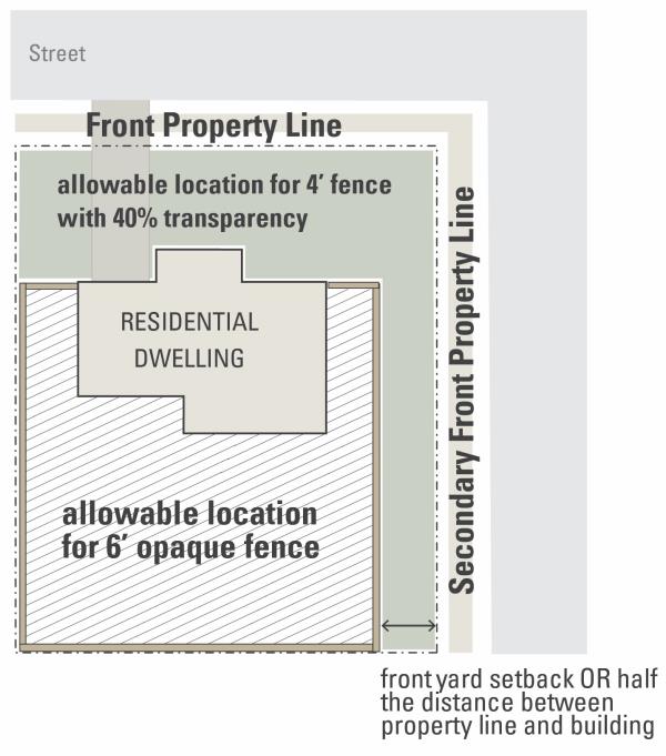
- For through lots, fences in the secondary front yard (between the secondary front property line and the rear building line of the structure) may be up to six feet in height and opaque if the fence is set back from the secondary front property line a minimum distance that is equal to the required front yard setback or one-half the distance between the secondary front property line and the rear building line, whichever is less.
- Fences located between the front property line and the primary entrance of the house are subject to the regulations in Section 1107.19(j)(2). Additionally, fences in the secondary front yard that are located between secondary front property line and the halfway point between the property line and the building line are subject to the regulations in Section 1107.19(j)(2).
- Interior Lots:
- Fence Construction: Fences and walls shall be constructed so all supporting cross-elements, exposed posts, or other similar features shall face the interior of the property. This provision shall not apply if the adjacent property owner(s) consent in writing to allow the supporting cross-elements or exposed posts to face outward towards the exterior of the property. Fences shall be erected so that no exposed posts or supporting cross-elements face public property. This provision shall not apply if the fence is the same on both sides such as split rail fences or board and batten fences.
- Double Fences: No fence or fences shall be constructed so that there are two more-or-less parallel fences in the same yard, unless there be a distance of at least five feet between the fences or their appurtenances.
- Snow Fences: Temporary snow fences, 42 inches or less in height, may be erected during the months of November through March each year. Such fences are to be used only to control the drifting of snow on walks, driveways, streets, or alleys.
- Mounds:
- No mound exceeding 32 inches in height.
- No mound shall be erected in the intersection clearance zone, as defined in Section 1107.19(j)(1), on corner lots.
- The grading and drainage of mounds shall follow the requirements set forth by the City Engineer.
- Retaining Walls, Dry-Stacked Stone Decorative Walls, and Entry Features: May be located in front yards, side yards, and rear yards as follows:
- Shall not exceed height of 36 inches if located in a front yard;
- Shall not be erected in the intersection clearance zone, as defined in Section 1107.19(j)(1)(F), on corner lots.
- General Requirements:
- Garages and Carports, Detached: Detached garages and carports are subject to the following regulations:
- Setbacks: No detached garage or carport shall be permitted nearer to any front lot line than 60 feet, provided that in the case of a corner lot, where the choice by the owner of the longer street lot line is approved, this requirement shall apply only to the distance of such building from the shorter street lot line. A detached garage or carport shall be distant at least 10 feet from any dwelling situated on the same lot, and at least three feet from any lot lines of adjoining lots and shall not occupy any easement.
- Timing of Construction: detached garage or carport shall be erected or constructed prior to the erection or construction of the principal or main building, except in conjunction with the same.
- Quantity: There shall be no more than one detached garage or carport per dwelling unit.
- Height: No detached garage or carport shall exceed the following height limitations, unless specifically permitted under separate City Ordinance; or, if converted to habitable use, shall exceed the rear yard height plane limits required for principal structures. A detached garage or carport roof shall not exceed the height dimensions allowed for the principal use, excepting that the Appeals Board may approve increased height to meet unusual circumstances as a variance if such a variance will not be detrimental to the adjacent property. The top plate wall height supporting all sloping roofs shall not exceed nine feet above the parking floor elevation of the garage, and the maximum height to coping or parapet for all flat and sloping roofs with pitches less than four feet of vertical rise in 12 feet of length shall not exceed 15 feet at any point above the parking floor elevation of the garage.
- Area Limits: The maximum area of a detached garage is 600 square feet. In no case shall the floor area of a detached garage or carport exceed 60 percent of the area of the dwelling unit.
- Home Occupations: The purpose of the provisions in this Section is to protect the character of residential neighborhoods while recognizing that advances in technology and telecommunications and changes in the job market have diminished the importance of traditional workplaces. These regulations are intended to recognize this shift and to allow in residential structures, where appropriately limited, nonresidential activities that are clearly subordinate and incidental to the residential use of the property and which are compatible with the residential character of the neighborhood.
- Home Occupation, Type A: This type of home occupation has little or no impact on the surrounding residential area and requires no permit. In general, a Home Occupation Type A is located and conducted so that the average neighbor, under normal circumstances, would not be aware of its existence. A Home Occupation Type A shall be a permitted accessory use in any residential district only if all of the following regulations are met:
- General:
- The use is compatible with the residential use of the property and the surrounding residential uses.
- Retail sales of merchandise, products or goods shall be prohibited, provided, however, that orders previously made by telephone, internet, or at a sales party or meeting may be filled on the premises. That is, direct retail sales of products or goods off display shelves or racks is not permitted, but client/customer may pick up an order placed earlier, as described above.
- Employees: The use is owned or conducted by one or more residents of the dwelling and only employs residents of the dwelling unit in which it is located.
- Area:
- The use is conducted wholly within the dwelling, and any space used for sales, service or production does not occupy more than 20 percent of the ground floor area of the dwelling unit.
- The use, including any storage of materials or equipment related thereto, shall be carried on entirely within the dwelling or unit and not in an accessory structures; however, part of the floor area of an attached garage may be used if the use does not occupy parking spaces required for the dwelling use by the parking regulations of this UDO, outlined in section 1111.07.
- The use shall not constitute primary or incidental storage facilities for a business, industrial or agricultural activity conducted on the premises.
- Exterior Appearance:
- The exterior appearance of any structure on the premises shall not be altered nor shall there be any structural modifications of the residence or garage, such as a separate business entrance. The use within the principal structure shall not be conducted in a manner that would cause the premises to differ from its residential character or which is inconsistent or incompatible with the normal scale, orientation or appearance of neighboring dwellings. No activity, materials, goods or equipment indicative of the use shall be visible from any public way or adjacent property.
- There shall be no outside appearance of the use, including, but not limited to, parking, signs or lights, excepting that one nameplate sign, attached flush to the dwelling and not exceeding two square feet in area shall be permitted. Neither freestanding nor illuminated signs shall be permitted.
- Hours of Operation:
- In no case shall the home occupation be open to on-site clients or customers earlier than 7:00 a.m., nor later than 7:00 p.m., excepting parties and meetings held for the purpose of selling merchandise or taking orders. Other motor vehicle traffic relating to the conduct of the use shall be prohibited between the hours of 10:00 p.m. and 6:00 a.m.
- Parties or meetings within the dwelling, held for the purpose of selling merchandise or taking orders, shall not be held more than four times each month.
- Parking/Traffic:
- On-site clients or customers shall not exceed six per day.
- The use does not necessitate the parking of more automobiles than can be accommodated in the dwelling or unit's driveway.
- The use shall not generate a significantly greater volume of traffic than would normally be expected in a residential area. The number of deliveries, pick-ups, origin, or destination trips relating to the use shall not exceed three per day.
- There shall be no merchandise or goods sold, or services rendered that require receipt or delivery of merchandise, goods or equipment other than by passenger motor vehicle, parcel delivery service, or U.S. mail service. No deliveries by tractor/trailer are permitted.
- Environmental Impact:
- No equipment or process shall be used which creates noise, vibration, glare, fumes, odors or electrical or electronic interference, including visible or audible interference with radio and television reception or which cause fluctuation in line voltage off the premises.
- The use shall not generate any solid waste or sewage discharge, in volume or in type, which is not normally associated with residential use in the neighborhood.
- No highly explosive, toxic or combustible material shall be used or stored on the premises.
- Other Applicable Laws or Regulations: The use may not involve any illegal activity; it shall be the homeowner's responsibility to ensure compliance with all applicable state and federal regulations.
- General:
- Home Occupation, Type B: This type of Home Occupation has the potential for greater impact on the surrounding residential area and therefore requires a Conditional Use Permit. All persons conducting home occupations that classify as Type B, and which are planned, presently existing, or which are established, changed or enlarged after this chapter is in effect, shall be required to obtain a Conditional Use Permit. Initial application for a Conditional Use Permit for a Home Occupation Type B shall require a public hearing.
- Application: The application process shall be the same as for other Conditional Uses under this Zoning Code.
- Regulations: A Conditional Use Permit for a Home Occupation Type B in any residential district may be granted if all of the following regulations are met:
- General:
- The use is compatible with the residential use of the property and the surrounding residential uses.
- The retail sales of products or goods, particularly products or goods produced on the premises, may be permitted by the Planning Commission provided that such merchandise or goods are specified and approved as a part of the application for the Permit, and provided that the Planning Commission determines that such retail sales will not become a detriment to or have an adverse impact on the existing residential character of the lot or neighborhood.
- Employees: The use is owned or conducted by residents of the dwelling unit in which it is located and employs not more than two employees who are not residents of the dwelling or unit.
- Area:
- The use is conducted within the dwelling, and any space used for sales, service or production does not occupy more than 25 percent of the ground floor area of the dwelling unit.
- Accessory structures may be used for storage of materials and equipment related to the use, provided that such buildings comply with setback and other requirements for accessory structures as contained in this UDO.
- The use shall not constitute primary or incidental storage facilities for a business, industrial or agricultural activity conducted off the premises.
- Exterior Appearance:
- Alterations to the exterior appearance of any structure in connection with the use may be permitted by the Planning Commission provided that such alteration is specified and approved as a part of the application for the Permit, and provided that the Planning Commission determines that such alteration will not cause the premises to differ from its residential character, nor be inconsistent or incompatible with the normal scale, orientation or appearance of neighboring dwellings. No activity, materials, goods or equipment indicative of the use shall be visible from any public way or adjacent property.
- Any signage shall be of the type and size permitted in the zoning district under the City's sign regulations, outlined in section 1111.08, and shall be approved by Planning Commission as a part of the Conditional Use Permit.
- Hours of Operation:
- Depending upon the foreseeable impact the intensity of a particular use may have on the surrounding neighborhood, it is within the discretion of the Planning Commission to limit the operations of a particular use to certain operating hours as a condition of granting a Permit. Should Planning Commission tail to establish operating hours for the use, in no case shall the home occupation be open to on-site clients or customers earlier than 7:00 a.m., nor later than 7:00 p.m., excepting parties and meetings held for the purpose of selling merchandise or taking orders.
- Parties or meetings within the dwelling for the purpose of selling merchandise or taking orders shall not be held more than four times each month.
- Parking and Traffic:
- Clients or customers shall not exceed 12 per day on average.
- At least two off-street parking spaces shall be provided, unless this requirement is waived by the Planning Commission. No required parking shall be provided in any front yard, except for the driveway, which may be used to fulfill this requirement. There shall be no paving or modification of the front yard for parking purposes other than the customary space used for the driveway.
- The use shall not generate a significantly greater volume of traffic than would normally be expected in a residential area. The number of deliveries, pick-ups, origin, or destination trips relating to the use shall not exceed five per day.
- There shall be no merchandise or goods sold, or services rendered that require receipt or delivery of merchandise, goods or equipment other than by passenger motor vehicle, parcel delivery service, or U.S. mail service. No deliveries by tractor/trailer are permitted.
- Environmental:
- No equipment or process shall be used which creates noise, vibration, glare, fumes, odors or electrical or electronic interference, including visible or audible interference with radio and television reception or which cause fluctuation in line voltage off the premises.
- The use shall not generate any solid waste or sewage discharge, in volume or in type, which is not normally associated with residential use in the neighborhood.
- No highly explosive, toxic or combustible material shall be used or stored on the premises.
- Other Applicable Laws or Regulations: The use may not involve any illegal activity; it shall be the homeowner's responsibility to ensure compliance with all applicable state and federal regulations.
- General:
- Validity: The Conditional Use Permit for the Home Occupation Type B may be issued for an initial period of one year and renewed for three year periods thereafter. Conditional Use Permits shall be specific to the owner of the Home Occupation and the dwelling or unit for which the Home Occupation is approved; they shall not be transferable to a subsequent owner of the designated dwelling or unit, nor shall they transfer with the owner to another location. A Home Occupation Type B shall terminate upon the dwelling no longer being used for such Home Occupation or upon the sale or change of ownership of such dwelling or land, or upon violation of any provisions of this Section.
- Renewals: The owner of the Home Occupation Type B is responsible for applying for renewals of the Conditional Use Permit. Upon application for renewal, the Zoning Inspector shall inspect the premises for conformance with the original Permit and shall review the record regarding the Permit and shall make a recommendation to the Planning Commission. If the Planning Commission finds no cause to disallow renewal of the application or cause for review of the application, the Planning Commission may authorize the Zoning Official to administratively approve the renewal application. If the Planning Commission determines the use has been the subject of unresolved complaints or violations of conditions or for other good cause, the Planning Commission may cause the application to come before the Planning Commission for a public hearing, may review the application as if it were a new application, and may renew the Permit as is, may renew the Permit with added conditions as the Planning Commission finds appropriate, or may deny and/or revoke the Permit.
- Revocations: The following shall be considered as grounds for the revocation of a Home Occupation Conditional Use Permit at any time during the term of the Permit:
- Any change in use or any change in extent of use, area of dwelling or unit being used, or mechanical or electrical equipment being used that is different from that specified as permitted in the granted Permit, which is not first approved by the Zoning Official.
- Any change in use or any change in extent of use, area of dwelling or unit being used, or mechanical or electrical equipment that results in a violation of these regulations.
- Failure to allow periodic inspections by the Zoning Official or his designee at any reasonable time when an adult member of the family is present.
- Miscellaneous:
- In the case of a dwelling or unit that is part of a common interest ownership community (a community in which at least some of the property is owned in common by all of the residents) the provisions of this Section shall not be deemed to supersede any deed restrictions, covenants, agreements, master deeds, by-laws or other documents that prohibit Home Occupations within dwellings or units in the community.
- The provisions of this Section shall not be construed as limiting in any manner the powers or authority of the City of Franklin to protect the health, safety and welfare of its residents, including the investigation and elimination of nuisances.
- Home Occupation, Type A: This type of home occupation has little or no impact on the surrounding residential area and requires no permit. In general, a Home Occupation Type A is located and conducted so that the average neighbor, under normal circumstances, would not be aware of its existence. A Home Occupation Type A shall be a permitted accessory use in any residential district only if all of the following regulations are met:
- Open-Sided Structures: Open-sided structures are subject to the following regulations:
- Height:
- All open-sided structures shall be limited to one story.
- The height to the top of the highest roof ridge beam, or to the highest point of any other roof form, from the finished floor may not exceed 15 feet.
- If the structure is built on a mound, deck, or other elevated surface, the height of this elevated surface at its highest point above grade shall be added to the height of the structure to determine the overall height of the structure being measured.
- Area: The area of an open-sided structure may not exceed 200 square feet.
- Materials: All finished roof surfaces, except for flat roofs, shall be metal, seal-tab asphalt shingles, clay tile, slate or wood shingles. All other finish surfaces shall be either wood, brick, stone, screen or any combination thereof.
- Location: All such structures shall be located at least five feet from any lot lines of adjoining lots, and shall not occupy any easement.
- Illumination: Illumination of the structure exterior is prohibited. Illumination within the structure shall not exceed 70 foot candles measured at a horizontal plane three feet above the finished floor.
- Height:
- Outdoor Dining: Outdoor dining areas may be permitted as an accessory use to a restaurant or similar use in the Downtown Districts, as approved by the city manager or their designee. The location of the outdoor dining area shall not interfere with pedestrian movement on any sidewalk or walkway by providing a clear sidewalk or walkway of at least four feet in width (considering the location of chairs when being used). Outdoor dining areas may be covered with a roof, trellis, or pergola; or may be closed permanently or temporarily to protect against the weather if approved by the city manager or their designee.
- Outdoor Retail and Display: Outdoor retail and/or display areas may be permitted as an accessory use to a retail store or similar use as approved by the city manager or their designee. The placement of merchandise shall not interfere with pedestrian movement on any sidewalk or walkway by providing a clear sidewalk or walkway of at least four feet in width. The placement of merchandise shall also not interfere with vehicular circulation or be located on any landscaped area.
- Outdoor Storage: Outdoor storage is subject to the following regulations:
- Commercial Districts: Outdoor storage areas shall be paved with a hard durable surface, be located only in the rear yard, and shall be screened on all sides with an opaque fence or wall that is six feet in height.
- Industrial Districts:
- Industrial uses that are allowed outdoor storage shall not have any material stored above a height of 20 feet. No storage shall be allowed within the front yard. All outdoor storage shall be enclosed by a fence not less than six feet and not more than 10 feet in height. Within areas of open storage, fire lanes shall be provided as required by the Fire Chief.
- No highly flammable or explosive liquids, solids or gases shall be stored in bulk above ground except in a light or heavy industrial district. Tanks or drums of fuel directly connected with heating devices or appliances located on the same lot as the tanks or drums of fuel are excluded from this provision.
- All outdoor storage of raw materials shall be contained by an enclosure, fence or wall in a manner to prevent transfer from the lot of said materials by wind, flood or natural causes or forces.
- When adjacent to a residential zoning district or a residential use, all outdoor storage facilities for fuel, raw materials and products shall be enclosed by a fence, wall or planting to conceal such facilities.
- No garbage shall be deposited upon a lot in such form or manner that it may be transferred from the lot by wind, flood or natural causes or forces. All garbage that might cause fumes or dust, constitute a fire hazard or be edible or attractive to rodents or insects, shall be stored outdoors only in closed containers constructed of impervious material.
- Parking Area: A parking area may be permitted as a principally permitted use or an accessory use in the Downtown Districts. The purpose of the parking area shall be to serve the property on which it is located, adjacent parcels, and/or to provide parking for the entire downtown Franklin area.
- Parking Garage: A parking garage may be permitted as a principally permitted use or an accessory use in the Downtown Districts. The purpose of the parking garage shall be to serve the property on which it is located, adjacent parcels, and/or to provide parking for the entire Downtown Franklin area.
- Parking of Recreational Vehicles and Watercraft: Parking of recreational vehicles and watercraft is subject to the following regulations:
- Long-Term Parking:
- Subject to the other provisions of this Section, all recreational vehicles, watercraft and recreational trailers located on a residential lot for longer than 24 hours in any 30 day period must be parked within a fully enclosed permanent structure.
- No more than one recreational vehicle, watercraft and/or recreational trailer may be located at one time on a single residential lot outside of an enclosed structure for longer than 24 hours in any 30 day period.
- Recreational vehicles, watercraft and recreational trailers parked outside of an enclosed structure for longer than 24 hours in any 30 day period must be located in the rear yard of the property, with all wheels situated on a paved parking surface, and screened from public view with opaque fencing which is a minimum of six feet tall.
- Short-Term Parking: Recreational vehicles, watercraft and recreational trailers may be parked for a maximum of 24 hours in any 30 day period on a paved driveway or street abutting the front yard of a residential lot, with the residential property owner’s permission (provided such street parking complies with all other applicable parking regulations and does not create a hazard for vehicular or pedestrian traffic).
- Improvements: No recreational vehicle, watercraft or recreational trailer shall be parked in any manner on a residential lot which is not improved with a principal building.
- Habitation/Guest Occupancy: A recreational vehicle, watercraft or recreational trailer may not be used for overnight sleeping or living while parked in a residential zoning district, unless the recreational vehicle, watercraft or recreational trailer is parked on a residential lot in compliance with Section 1345.10(c), with the permission of the owner or occupant in charge of the residential real property, and such use of the recreational vehicle, watercraft or recreational trailer does not exceed, 72 hours in any 30 day period.
- Storage: No parked recreational vehicle, watercraft or recreational trailer shall be used as a means of permanent storage for any materials the (excepting items customarily used in connection with the use of a recreational vehicle, watercraft or recreational trailer, including but not limited to dishes, linens, and other items used in the course of recreational travel).
- Registration: All recreational vehicles and recreational trailers shall be operable and have borne valid registration and licenses within the most recent 12 month period. All watercraft shall be operable and have been registered within the most recent 12 month period. Operable in the case of a powered vehicle means a vehicle capable of being started and driven from the location in question. Operable in the case of a non-powered or waterborne vehicle means a vehicle capable of being safely towed from the location in question.
- Maintenance/Condition: All recreational vehicles, watercraft or recreational trailers parked in a residential zoning district shall be maintained in good condition and repair. An inadequately maintained recreational vehicle, watercraft or recreational trailer which is not parked in a fully enclosed structure may be removed from residential premises by the City, when the vehicle, watercraft or trailer is in a state of disrepair and apparently inoperable; provided, the City has first given written notice to the owner of the associated residential real property of the inadequate condition of the vehicle, watercraft or trailer and a reasonable opportunity to remove the vehicle, watercraft or trailer from the premises.
- Safety: No recreational vehicle, watercraft or recreational trailer shall be parked in any manner which is unsafe or otherwise poses a hazard to the safety of real or personal property. Recreational vehicles, watercraft and recreational trailers parked in a manner which poses a safety concern or hazard may be immediately removed by the City with or without prior notice to the owner of residential real property on which, or abutting the area where, the vehicle, watercraft or trailer is parked.
- Long-Term Parking:
- Pick-Up Window for Retail or Restaurant Use: Pick-up windows for retail or restaurant uses are subject to the following regulations:
- Allpick-up areas, including but not limited to stacking lanes, trash receptacles, window openings, and other objects associated with the pick-up window shall be located in the side or rear yard of the property, and shall not cross, interfere with, or impede any public right-of-way.
- Audible electronic devices such as loudspeakers and similar instruments shall not be permitted.
- Pick-up windows for retail or restaurant uses are subject to the vehicle stacking requirements of Table 1111.07-2: Required Number of Stacking Spaces.
- Playground Equipment: Playground equipment must be set back from all adjacent residential properties a minimum of 25 feet.
- Solar Panels, Roof-Mounted: Roof-mounted solar panels are subject to the following regulations:
- Roof-mounted solar panels are permitted on the roof of any principally permitted structure and are permitted on the roof of any accessory structure over 100 square feet in area.
- Roof-mounted solar panels, on pitched roofs, shall be flush-mounted to the roof and shall not extend higher than the top ridgeline of the roof in which they are located.
- Roof-mounted solar panels on flat roofs shall not project more than six feet above the rooftop structure, and shall not exceed the maximum height allowance in the zoning district in which they are located.
- Roof-mounted solar panels shall be placed so that concentrated solar radiation or glare shall not be directed onto other properties or roadways in the vicinity.
- Storage Structure: Storage structures are subject to the following regulations:
- Residential and Agricultural Uses:
- Storage structures shall be located in the rear yard only and shall be set back a minimum of three feet from the side and rear property lines.
- Maximum height is 15 feet, except for lots over two acres where the maximum height is 20 feet. In no case shall a storage structure exceed the maximum height of the principal building.
- A maximum of two storage structures are permitted per lot.
- The cumulative size of the storage structures shall not exceed 20 percent of the footprint of the square footage of the principal building. For lots over two acres, the cumulative size of the storage structures shall not exceed the square footage of the footprint of the principal building.
- Commercial and Industrial Uses:
- Storage structures shall be located in the rear yard only and shall be set back a minimum of three feet from all side and rear property lines.
- Maximum height is 20 feet. In no case shall a storage structure exceed the maximum height of the principal building.
- A maximum of two storage structures are permitted per lot.
- The cumulative size of all storage structures on a property shall not exceed 35 percent of the square footage of the footprint of the principal building.
- Public and Institutional Uses:
- Storage structures shall not be located in the front yard setback and shall be set back a minimum of three feet from all side and rear property lines.
- Maximum height is 15 feet.
- A principal building is not required in this district to construct a storage structure when the structure is to be used in conjunction with a recreation, parks, open space, or other similar use that may not require a principal building.
- Residential and Agricultural Uses:
- Swimming Pools and Hot Tubs, Private: Private swimming pools and hot tubs shall be subject to the following regulations:
- Location, Area, and Height:
- All hot tubs shall be located within the buildable area. In the event a proposed hot tub has more than 150 square feet of area on the water surface when filled to capacity, all regulations for swimming pools shall apply.
- All swimming pools or parts thereof shall be located in the rear yard, shall be at least ten 10 feet (10') from the side or rear line of the lot or parcel upon which it is situated, and shall be at a distance 10 feet greater than the building setback line as fixed by the UDO from any street on which such lot or parcel abuts. The area of the swimming pool proper, including decks, walks and other appurtenances, shall not exceed the percentage of lot area specified in Section 1107.19(a)(4).
- Swimming pool accessories are limited to diving boards, slides and lights designed to illuminate the pool and the immediate surrounding area. None of these accessories may exceed 10 feet in height, such height to include rails, supports and other safety devices, and may not cover a ground surface area in excess of 30 square feet.
- Fences or Barriers:
- Every swimming pool shall be completely enclosed by a fence or barrier of sturdy construction not less than 48 inches in height, measured from the level of the ground where located, which shall be of such design and construction as to effectually prevent a child from crawling or otherwise passing though or under such fence. Each gate in such fence or barrier shall be provided with a self-latching gate. Where the top of the pool structure is above grade, such as an aboveground pool, the barrier shall be permitted to be at ground level, such as the pool structure, or mounted on top of the pool structure. No part of any fence shall be located between the building setback line and the street on which the lot or parcel abuts.
- A variance may be requested to make exceptions to, or modifications of, the requirements of this paragraph for fences in cases in which, in Appeals Board's opinion, such requirements are not essential to safety and the enforcement thereof would place undue hardships on the owners.
- Lights: All
lights used for illuminating a swimming pool, hot tub or the surrounding areas shall be so designed, located and installed as to confine the direct beams thereof to the lot or parcel on which the pool or hot tub is located, and so as not to constitute a nuisance or undue annoyance to occupants of abutting property. - Drainage: Provisions shall be made for drainage of the swimming pool into a public storm sewer where possible or sanitary sewer, in which case drainage may be into such ditch or watercourse. Permission must be obtained from the Zoning Official before the swimming pool is drained in whole or in any substantial amount, in order to prevent overloading the sewer or ditch in times of heavy rain. In no case shall the swimming pool be drained, directly or indirectly, into any street or onto any neighboring property which is not owned by the pool owner.
- Location, Area, and Height:
- Construction Trailers: Construction trailers are subject to the following regulations:
- A construction trailer and offices, with fixed connections to utilities such as electric and telephone, may be used for temporary office and storage use during the duration of construction on a site. Such uses are required to get the approval of the Zoning Official prior to locating on a site.
- The storing of construction materials and equipment, both incidental and necessary for construction, is permitted during the period of construction and development for a maximum of 18 months.
- Festivals and Circuses: Festivals and circuses are subject to the following regulations:
- Festivals and circuses, which are sponsored by a governmental, educational, or religious entity, are exempt from the requirements of this section.
- The operator, if not the owner of the property, shall provide a written agreement from the property owner to the City of Franklin stating the owner’s permission for the proposed use of the property.
- Festivals, circuses, and other similar special events are permitted for a maximum of 14 days.
- No activities shall take place in the public right-of-way.
- Mobile Uses: Mobile uses (such as food trucks, blood drive trucks, or pop-up clothing shops) are subject to the following regulations:
- Mobile uses may be located on private property if the property owner has granted permission. Such mobile food uses shall be located in a designated spot and for a length of time as determined by the property owner and approved by the city manager or their designee.
- Mobile uses may locate in the public right-of-way if the right-of-way is closed for a special event or if the mobile use is located in a designated parking spot for mobile uses and the location and duration is approved by the city manager or their designee.
- Mobile uses may be allowed at events on public property with the approval of the city manager or their designee.
- Waste shall be contained and disposed of in a manner required by law.
- The applicant shall be responsible for obtaining all permits and approvals that may be necessary for the mobile food use including, but not limited to, health, fire, police, and zoning department approvals.
- Model Home: Model homes are subject to the following regulations
- Model homes, with or without a sales/leasing center may be used during the duration of construction for the residential development.
- The model home shall either be removed or converted into a permanent residence upon the construction of the final dwelling in the development.
- Any signage on the model home property must comply with the regulations in Section 1111.08.
- A maximum of one model home is permitted per phase of development.
- Model homes, with or without a sales/leasing center may be used during the duration of construction for the residential development.
- Residential Sales: Residential sales are subject to the following regulations:
- Prohibitions
- No person shall sell, or offer for sale, at such home sale any merchandise that has been purchased, consigned or otherwise acquired for purposes of resale. The offering of new merchandise for sale shall be evidence that such merchandise was acquired by the resident for purpose of resale. No person shall sell, or offer for sale, at such home sale any personal property except such as has been owned and maintained by such person or members of his family on or in connection with the premises on which such sale is held.
- This prohibition shall not apply to not-for-profit corporations, churches, temples, schools, fraternities, sororities, associations, clubs or lodges. Such organizations may conduct sales of personal property donated to them on real estate owned or occupied by such organizations.
- Frequency and Duration of Sales: Only one such sale may be conducted on any parcel of real estate in any two month period, which sale shall be limited to not more than four consecutive days or two consecutive weekends of two days each. No sale may commence before the hour of 8:00 a.m. or extend later than 8:00 p.m.
- Other Conditions of Sales: No sign advertising a home sale may be displayed at any place except on the premises on which the sale is held. Only one such sign may be displayed, and its display shall be limited to the dates and hours during which the sale is held. Such sign shall not be larger than four square feet in area, shall not be illuminated or animated, and shall not contain any advertising material unrelated to the conduct of the sale.
- Exemptions: Except as provided in (3) above, these provisions shall not apply to a sale of property publicized solely by classified advertising by newspaper or internet, which describes or identifies the specific property offered for sale and does not designate the date, hours or location of the sale other than by stating the name, address or telephone number of the seller.
- Prohibitions
- Residential Storage Units (PODs): Residential storage units are subject to the following:
- Residential storage units shall be permitted as a temporary use for a period not to exceed 30 days within any one year period.
- Residential storage units shall be located on a hard, durable paved surface and out of the public right-of-way.
- If the portable storage unit is being used to store personal property as a result of a major calamity at the residence (e.g., fire, flood, or other event where there is significant property damage), the Zoning Official may extend the time period up to one year at their discretion.
- Residential storage units shall not exceed a size of 1,200 cubic feet on the interior. All residential storage units in excess of 1,200 cubic feet are prohibited in residential areas.
- Seasonal Sales: The seasonal sale of items pertaining to a holiday, event, or season such as the sale of Christmas trees or pumpkins is subject to the following:
- Seasonal sales, which are sponsored by a governmental entity, are exempt from the requirements of this section.
- The operator, if not the owner of the property, shall provide a written agreement from the property owner to the City of Franklin stating the owner’s permission for the proposed use of the property.
- A seasonal sale is limited to a maximum of 60 cumulative days per calendar year.
- Special Event: Special events that are not classified as a festival, circus, or farm market may be permitted in the Downtown Districts subject to the approval of the City. Such events may take place on private or public property for a duration that is specified in the approval.
- Dimensional Standards: The dimensional standards table in this section identifies the specific dimensional standards that apply to the (A-1) Agricultural Zoning District and the (PAR) Parks and Recreation Zoning District.
- Multiple Buildings: More than one main/primary/prinicpal building is permitted per lot in the (PAR) Parks and Recreation District, if approved by the Planning Commission on a Major Site Plan.
TABLE 1107.13-1: A-1 and PAR Dimensional StandardsA-1 PAR Minimum Lot Area 1 acre N/A Minimum Lot Frontage 100 feet 40 feet Minimum Front Yard Setback 25 feet 25 feet Minimum Side Yard Setback (one side/total) 10/25 feet 10/25 feet Minimum Rear Yard Setback 40 feet 40 feet Minimum Parking Lot/Driveway Setback1 20 feet - front P/L
10 feet - side P/L
10 feet - rear P/L20 feet - front P/L
10 feet - side P/L
10 feet - rear P/LMinimum Height 35 feet 35 feet Maximum Accessory Structure Height Per Section 1107.19 Per Section 1107.19 Maximum Impervious Coverage 30% 25%
Terminology: N/A = Not Applicable, P/L = Property Line
1The side yard setback for driveways shall not apply when there is a shared driveway that is located on or adjacent to the property line and serves multiple properties, uses, or structures. The setback from the front property line does not apply to access drives/driveways or at a roadway intersection.
- Dimensional Standards: The dimensional standards table in this section identifies the specific dimensional standards that apply to each residential zoning district.
- Multiple Buildings: More than one main/primary/principal building is permitted per lot in the (R-4) Multi-Family Residential District, if approved by the Planning Commission on a Major Site Plan.
TABLE 1107.14-1: Residential Districts Dimensional Standards
| R-1A | R-1B | R-2 | R-3 | R-4 | |
| Minimum Lot Area | 15,000 sq. ft. | 10,000 sq. ft. | 6,000 sq. ft. | 4,000 sq. ft. | 10,000 sq. ft. |
| Minimum Lot Frontage | 100 feet | 80 feet | 60 feet | 40 feet | 100 feet |
| Minimum Front Yard Setback | 25 feet | 25 feet | 25 feet | 15 feet | 25 feet |
| Minimum Side Yard Setback (one side/total) | 10/25 feet | 10/25 feet | 6/15 feet | 4/10 feet | 10/25 feet |
| Minimum Rear Yard Setback | 40 feet | 40 feet | 30 feet | 20 feet | 40 feet |
| Minimum Floor Area | 1,800 sq. ft. | 1,500 sq. ft. | 1,000 sq. ft. | 800 sq. ft. | 800 sq. ft. |
| Minimum Parking Lot/Driveway Setback1 | 3 feet from side property line | 3 feet from side property line | 3 feet from side property line | 3 feet from side property line | 20 feet - front P/L 10 feet - side P/L 10 feet - rear P/L |
| Maximum Height | 35 feet | 35 feet | 35 feet | 35 feet | 55 feet |
| Maximum Accessory Structure Height | Per Section 1107.19 | Per Section 1107.19 | Per Section 1107.19 | Per Section 1107.19 | Per Section 1107.19 |
| Maximum Impervious Coverage | 40% | 40% | 50% | 70% | 70% |
Terminology: N/A = Not Applicable, P/L = Property Line, Sq. Ft. = Square Feet
1The side yard setback for driveways shall not apply when there is a shared driveway that is located on or adjacent to the property line and serves multiple properties, uses, or structures. The setback from the front property line does not apply to access drives/driveways or at a roadway intersection.
- Dimensional Standards: The dimensional standards table in this section identifies the specific dimensional standards that apply to each commercial zoning district.
TABLE 1107.15-1: Commercial Districts Dimensional StandardsC-1 C-2 Minimum Lot Area N/A N/A Minimum Lot Frontage 40 feet 40 feet Minimum Front Yard Setback 35 feet 0 feet Minimum Side Yard Setback 0/10 feet1 10/25 feet Minimum Rear Yard Setback 0/30 feet1 40 feet Minimum Parking Lot/Driveway Setback2 20 feet - front P/L
10 feet - side P/L
10 feet - rear P/L20 feet - front P/L
10 feet - side P/L
10 feet - rear P/LParking Location Front/Side/Rear Side/Rear Maximum Height3 35 feet and 50 feet for vertically mixed use buildings 35 feet and 50 feet for vertically mixed use buildings Maximum Accessory Structure Height Per Section 1107.19 Per Section 1107.19 Maximum Impervious Coverage N/A N/A
Terminology: N/A = Not Applicable, P/L = Property Line 1The greater setback number is required when adjacent to a residential use or district.
2The side yard setback for driveways shall not apply when there is a shared driveway that is located on or adjacent to the property line and serves multiple properties, uses, or structures. The setback from the front property line does not apply to access drives/driveways or at a roadway intersection.
3When a building is more than 35 feet in height, an additional foot of rear yard is required for each additional two feet in height. Any building that exceed maximum height shall only be allowed as a conditional use.
- Dimensional Standards: The dimensional standards table in this section identifies the specific dimensional standards that apply to each of the downtown zoning districts.
Table 1107.16-1: Downtown Districts Dimensional StandardsDC-1 MU-1 RMU CV-1 TN-1 TN-2 Minimum Lot Area N/A N/A N/A N/A 4,000 sq. ft. 4,000 sq. ft. Minimum Lot Frontage 40 feet 40 feet 40 feet 40 feet 40 feet 40 feet Minimum Front Yard Setback 0 feet 0 feet 0 feet 0 feet 25 feet 25 feet Maximum Front Yard Setback 20 feet N/A N/A N/A N/A N/A Minimum Side Yard Setback (one side/total) 0 feet 0 feet 0 feet 0 feet 4/10 feet 4/10 feet Minimum Rear Yard Setback 0 feet 0 feet 0 feet 0 feet 20 feet 20 feet Minimum Floor Area (residential uses) N/A N/A N/A N/A 800 sq. ft. 800 sq. ft. Minimum Parking Lot/Driveway Setback1 N/A N/A N/A N/A 3 feet from side property line 3 feet from side property line Parking Location Side/Rear Side/Rear Side/Rear Front/Side/Rear Front/Side/Rear Front/Side/Rear Maximum Height 50 feet 75 feet 50 feet 40 feet 40 feet 40 feet Maximum Accessory Structure Height Per Section 1107.19 Per Section 1107.19 Per Section 1107.19 Per Section 1107.19 Per Section 1107.19 Per Section 1107.19 Maximum Impervious Coverage N/A N/A N/A 70% 70% 70%
Terminology: N/A = Not Applicable, P/L = Property Line, Sq. Ft. = Square Feet
1The side yard setback for driveways shall not apply when there is a shared driveway that is located on or adjacent to the property line and serves multiple properties, uses, or structures. The setback from the front property line does not apply to access drives/driveways or at a roadway intersection. - Downtown Design Standards:
- Character:
- New development and redevelopment projects within Downtown Franklin shall conform to the recommendations in the Downtown Franklin Master Plan and be complementary to the existing character of the area.
- Creativity in design is encouraged, though, and this section is not intended to limit unique or iconic designs.
- Each project will be evaluated by the Planning Commission on its size, scale, design, materials, mass, location, and compatibility with adjacent uses.
- Materials:
- A minimum of three building materials shall be used on every building façade (transparent glass may count as one of the building materials. Roofing materials, awnings, canopies, balconies, or other similar items do not count as one of the required materials).
- Permitted building materials shall be high quality, durable materials including but not limited to stone, manufactured stone, brick, wood and composite wood siding, glass, architectural metal panels, and fiber cement siding.
- EIFS (Exterior Insulation and Finish System) and stucco may be used as accent materials on the building facades but may not account for more than 15 percent of each building façade. Vinyl siding is prohibited.
- Other equivalent building materials may be approved by the Planning Commission
- Form/Massing:
- All building elevations shall consist of a tripartite configuration consisting of a base or foundation; a middle or modulated wall; and a top portion formed by an articulated roof. The minimum height of the base or foundation shall be 18 inches in height and shall be faced with an articulated masonry, cement, or similar manufactured material. Smooth concrete does not meet this requirement.
- All building elevations shall be articulated in a manner to avoid an uninterrupted appearance through the use of windows, doors, offsets, or a change in materials. Building facades that face a public right-of-way, and that are over 40 feet in length shall implement at least one of the following at least every 20 lineal feet along the frontage:
- Recesses or projections in the wall that are at least one foot in depth. Balconies or decks can be used to meet this requirement.
- Façade material or color changes. Windows can be used to break up the façade to meet this requirement.
- Pilasters, columns, or other similar architectural details that are a minimum of one foot wide.
- Other similar articulation methods may be approved by the Planning Commission.
- Buildings shall be designed for the pedestrian and should promote an active street frontage and high-quality streetscape design, on all frontages that face a public right-of-way. The primary building entrance shall be clearly identified and shall be oriented to a public street or public gathering area.
- Window Openings: First floor elevations, for non-residential uses that are visible from the public right-of-way, shall maximize window openings as appropriate for the interior use. The first 10 feet of the building, as measured from building grade up, shall provide a minimum of 60 percent transparency with the use of clear, glass windows. Glass block, opaque, mirrored glass, or darkly tinted glass does not meet this standard.
- Lighting: LED, neon tubing, and string lights that are being used as building accent lighting or window trimming are prohibited in the Downtown Districts. String lights may be used as decoration around outdoor eating and drinking areas, parks, public spaces, or gathering areas.
- Mechanical Equipment Screening: All roof and ground mounted mechanical equipment shall be screened from view from all adjacent properties and rights-of-way using durable, compatible, opaque materials.
- Waivers: The Planning Commission may alter or waive the requirements of this section if the commission deems that the applicant meets the intent of this section.
- Landscaping:
- Bufferyards: Bufferyard landscaping requirements as established in Section 1111.06(g), shall not apply to lots within the Downtown Districts.
- Parking Lot Landscaping: Parking lot perimeter screening and interior parking area landscaping, as established in Section 1111.06(j), shall apply only to parking lots within the Downtown Districts that are visible from the public right-of-way. Parking garages or parking decks shall not be required to provide interior parking area landscaping.
- Lot Interior Landscaping: Where feasible, lots within the Downtown Districts shall meet the interior landscaping requirement as established in Section 1111.06(k)(1).
- Building Foundation Plantings: Where feasible, building foundation plantings shall be required, as established in Section 1111.06(k)(2). Building foundation plantings are not required for buildings that are located within 15 feet of the front property line and where a streetscape or patio treatment is provided between the front building facade and the right-of-way.
- Modifications: The Planning Commission may waive any of the landscaping requirements that apply to lots within the Downtown Districts if the landscaping requirement is not feasible due to the size, configuration, or location of such lot.
- Signage:
- Signage Requirements: Signs in the Downtown Districts shall conform to the applicable regulations in Section 1111.08 unless specially exempted or regulated within this section.
- Residential Signage Requirements: Single family and two family residential uses shall conform to the applicable residential sign regulations.
- Parking:
- Parking Requirements: Off-street parking within the Downtown Districts should be reviewed and considered on a district-wide basis and per the recommendations of the Downtown Franklin Master Plan. Due to the configuration, size, and location, of many of the lots within this area, individual parcels cannot provide the off-street parking spaces that would typically be required. Where feasible, new and redevelopment projects within the Downtown Districts shall conform to the regulations in Section 1111.07, unless otherwise exempted or regulated within this section.
- Downtown Core, Mixed Use, and Riverfront Mixed Use District Requirements: The Downtown Core, Mixed Use, and Riverfront Mixed Use Districts are exempt from the off-street parking requirements of Section 1111.07.
- Civic and Transitional Neighborhood District Requirements: Lots within the Civic and Transitional Neighborhood Districts shall conform to the applicable regulations in Section 1111.07.
- Modification: The Planning Commission may waive any of the off-street parking requirements that apply to lots within the Downtown Districts if the requirements are not feasible due to the size, configuration, or location of such lot. Considerations will be taken for available on-street parking, joint parking areas, cross-parking agreements, and destinations lots that serve the district.
- Character:
- Dimensional Standards: The dimensional standards table in this section identifies the specific dimensional standards that apply to each office zoning district.
TABLE 1107.17-1: Office District Dimensional StandardsO-1 O-RP O-S Minimum Lot Area N/A 10 acres1 N/A Minimum Lot Frontage 40 feet 40 feet 40 feet Minimum Front Yard Setback 35 feet 50 feet 35 feet Minimum Side Yard Setback22 0/30 feet 0/30 feet 0/30 feet Minimum Rear Yard Setback 0/30 feet 0/30 feet 0/30 feet Minimum Parking Lot/Driveway Setback3 20 feet - front P/L
10 feet - side P/L
10 feet - rear P/L20 feet - front P/L 10 feet - side P/L 10 feet - rear P/L 20 feet - front P/L 10 feet - side P/L 10 feet - rear P/L Parking Location Front/Side/Rear Front/Side/Rear Front/Side/Rear Maximum Height4 35 feet 35 feet 35 feet Maximum Accessory Structure Height Per Section 1107.19 Per Section 1107.19 Per Section 1107.19 Maximum Impervious Coverage 70% 70% 70%
Terminology: N/A = Not Applicable, P/L = Property Line
1Unless otherwise approved by the Planning Commission.
2The greater setback number is required when adjacent to a residential use or district.
3The side yard yard setback for driveways shall not apply when there is a shared driveway that is located on or adjacent to the property line and serves multiple properties, uses, or structures. The setback from the front property line does not apply to access drives/driveways or at a roadway intersection.
4When a building is more than 35 feet in height, an additional foot of rear yard is required for each additional two feet in height. Any building that exceed maximum height shall only be allowed as a conditional use.
- Dimensional Standards: The dimensional standards table in this section identifies the specific dimensional standards that apply to each industrial zoning district.
TABLE 1107.18-1: Industrial Districts Dimensional StandardsI-1 I-2 Minimum Lot Area N/A N/A Minimum Lot Frontage 200 feet 200 feet Minimum Front Yard Setback1 35/50 feet 25/50 feet Minimum Side Yard Setback1 15/50 feet 15/100 feet Minimum Rear Yard Setback1 15/50 feet 15/50 feet Minimum Parking Lot/Driveway Setback2 20 feet - front P/L
10 feet - side P/L
10 feet - rear P/L20 feet - front P/L 10 feet - side P/L 10 feet - rear P/L Parking Location Front/Side/Rear Front/Side/Rear Maximum Height3 75 feet 75 feet Maximum Accessory Structure Height Per Section 1107.19 Per Section 1107.19 Maximum Impervious Coverage 80% 80%
Terminology: N/A = Not Applicable, P/L = Property Line
1When adjacent to a residential use or district.
2The side yard setback for driveways shall not apply when there is a shared driveway that is located on or adjacent to the property line and serves multiple properties, uses, or structures. The setback from the front property line does not apply to access drives/driveways or at a roadway intersection.
3When a building is more than 35 feet in height, an additional foot of rear yard is required for each additional two feet in height. Any building that exceed maximum height shall only be allowed as a conditional use.
- Percentages and Fractions: When a measurement results in a fractional number or percentage, and fraction or percentage of less than 0.5 shall be rounded down to the next lower whole number, and any fraction equal to or more than 0.5 shall be rounded up to the next higher whole number.
- Distances: When a minimum distance between buildings or uses is specified, such distance shall be measured in a straight line without regard to intervening structures or objects, between the closest lot lines of the properties in question.
- Structure Height:
- The vertical distance measured from the established grade to the:
- Highest point of the roof surface for flat roofs;
- Deck line of mansard roofs; and
- Average height between eaves and ridge for sloped, gable, hip, and gambrel roofs.
- Where a structure is located on a sloping terrain, the height may be measured from the average ground level of the grade at the building wall.
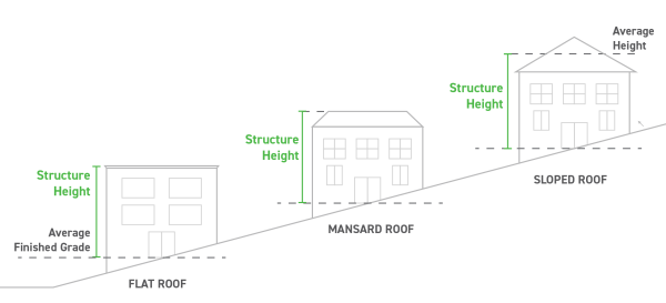
- The vertical distance measured from the established grade to the:
- Exceptions to Height Limitations:
- Chimneys, domes, spires, and necessary mechanical appurtenances and radio and television towers may exceed height limitations.
- Public, semipublic or public service buildings, hospitals, institutions or schools, where permitted, may be erected to a height not exceeding 90 feet when the required side and rear yards are each increased by one foot for each foot of additional building height above the height regulations for the district in which the building is located.
- Radio and television towers for residential uses shall be located centrally on a contiguous parcel having a dimension at least equal to the height of the tower measured from the center of the base of the tower to all points on each property line.
- Setbacks and Yards:
- Yard Projections:
- Chimneys, flues, sills, pilasters, cornices, eaves, gutters and other similar features may project into a side yard setback a maximum of 12 inches.
- Porches and steps may project into the front yard setback of a dwelling unit, but shall have a setback of ten 10 feet (10'), and no other structural projections will be permitted.
- Clear Sight Triangle: No fence, wall, sign, structure, vehicle, or planting shall be erected or maintained on any corner lot within the clear sight triangle. The sight triangle shall be formed by measuring 20 feet out in each direction of the street intersection.
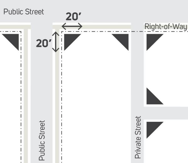
- Yard Projections:
- Lot Requirements:
- Interior Lots:
- The required minimum front yard setback shall be measured from the property line.
- The rear yard setback shall be measured from the line located directly behind the structure and the rear lot.
- In cases where the rear lot line is not parallel with the front property line or the side lines are not perpendicular to the front property line, average dimensions may be used to determined setback requirements.
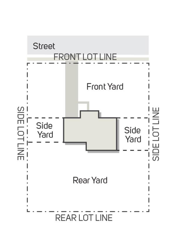
- Corner Lots:
- In any district, the side yard of a corner lot that abuts the side street shall have the same setback requirements as the front yard. The Zoning Official shall determine which is the front yard and which is the street side yard.
- A rear yard shall be provided parallel and opposite from the front yard.
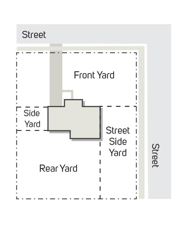
- Culs-de-sac or Curved Lots:
- For a cul-de-sac lot or a lot abutting a curved street, the front yard setback shall follow the curve of the front property line.
- Lots on a culs-de-sac shall be required to have a minimum lot width of 40 feet as measured from the front property line.
- Through Lots:
- The required minimum front yard setback shall apply for each side of the lot that has frontage on a street.
- The remaining lot lines shall be considered side lot lines, and the side yard setbacks shall be applied to those lot lines.
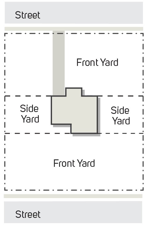
- Flag Lots: Flag lots are lots that utilize a narrow strip of land or stem to provide access to a public street. Flag lots are subject to the following:
- The minimum width of the flag lot stem is 40 feet.
- The stem of the flag lot is not considered a building site, nor is the area of such included in the calculation of lot area.
- The front yard setback is not measured from the frontage at the public street, but along the front lot line of the buildable area.
- Lots Abutting Alleys: In calculating the area of a lot that adjoins an alley for the purpose of applying lot area requirements of this UDO, one-half the width of such alley abutting the lot shall be considered as part of such lot.
- Interior Lots:
1109.02 Floodplain Overlay District
1109.03 Well Field Protection Overlay District
1109.05 Planned Unit Development District
1109.07 Highway Sign Overlay District
- Intent: Increasing competition in the telecommunications industry, especially in the market for wireless telecommunications services, is increasing the demand for antenna sites on Towers and other Antenna Support Structures necessary for providing wireless service. The Telecommunications Act of 1996 preserves the authority of the City to regulate the placement, construction, and modification of Towers, Support Structures and/or Wireless Telecommunications Facilities to protect the health, safety and welfare of the public consistent with the Telecommunications Act of 1996. This Section creates a Telecommunication Overlay District, and places certain prohibitions upon the placement of Towers, Antenna Support Structures and/or Wireless Telecommunications Facilities in the City of Franklin in order to protect the health, safety and welfare of the citizens, without prohibiting any person from providing wireless telecommunications services. The regulations for the Telecommunication Overlay District, as outlined in this section, are intended to maintain a high character of community development, to protect and preserve property, to promote the stability of property values, and to protect real estate from impairment or destruction of value for the general community welfare by regulating the location of Towers, Antenna Support Structures and/or Wireless Telecommunications Facilities within the City.
- Purpose: The purpose of this Overlay District is to regulate the placement, construction and modification of Towers, Antenna Support Structures and/or Wireless Telecommunications Facilities in order to protect the health, safety and welfare of the public, while at the same time not unreasonably interfering with the development of the competitive wireless telecommunications marketplace in the City.
- Objectives: The following are the objectives of the Telecommunications Overlay District:
- To comply with the Telecommunications Act of 1996 to include any of the follow-on rule making and/or rule interpretations by the appropriate state and federal agencies and/or courts.
- To work pro-actively with the various wireless telecommunications service providers to ensure rapid and reliable deployment of their services/technologies, while minimizing negative impacts on the City.
- To direct the location of Towers, Antenna Support Structures and/or Wireless Telecommunications Facilities in the City.
- To make available appropriate City owned property and structures for wireless telecommunications facilities.
- To minimize adverse visual impacts of Towers, Antenna Support Structures and/or Wireless Telecommunications Facilities through careful design, siting, landscaping, and innovative camouflaging techniques.
- To promote and encourage shared use/co-location of Towers, Antenna Support Structures and/or Wireless Telecommunications Facilities as a primary option rather than construction of additional single-use Towers, Antenna Support Structures and/or Wireless Telecommunications Facilities.
- To avoid potential damage to adjacent properties caused by Towers, Antenna Support Structures and/or Wireless Telecommunications Facilities by ensuring such structures are soundly and carefully designed, constructed, modified, maintained and removed.
- To the greatest extent feasible, ensure that Towers, Antenna Support Structures and/or Wireless Telecommunications Facilities are compatible with surrounding land uses.
- To the greatest extent feasible, ensure that proposed Towers, Antenna Support Structures and/or Wireless Telecommunications Facilities are designed in harmony with natural settings and in a manner consistent with current development patterns.
- To protect the community from inappropriately placed Towers, Antenna Support Structures and/or Wireless Telecommunications Facilities and the general proliferation of such structures.
- Applicability: All Towers, Antenna Support Structures and/or Wireless Telecommunications Facilities, any portion of which are located within the City, are subject to this section. (The boundaries of the Telecommunications Overlay District are outlined on Map attached at the end of this Chapter.) Except as provided in this section, any use being made of a pre-existing Towers, Antenna Support Structures and/or Wireless Telecommunications Facilities on the effective date of this Section (herein “Nonconforming Structures”) shall be allowed to continue, even if in conflict with the terms of this section; however, all re-construction or modifications to a Nonconforming Structure shall comply with paragraph (q) hereof.
Requirements: - General Requirements: Towers, Antenna Support Structures and/or Wireless Telecommunications Facilities shall be treated as permitted uses subject to administrative approval, special permit uses, or conditional uses in a variety of zoning districts, contingent upon a number of requirements being met. These criteria are in place in an attempt to minimize adverse health, safety, public welfare or visual impacts through co-location, siting, design and construction.
- The City's intent is to provide incentives for Wireless Telecommunications Service Providers that seek to further the City's following priorities:
- Co-locate on/with other existing towers, structures and/or facilities or locate on existing structures, whether public or private.
- Design new towers for multiple users, wherever possible.
- Locate towers in the least obtrusive manner given present and evolving technology.
- Table 1 summarizes the City's zones and prioritizes the required process.
TABLE 1: Zoning Districts
** The goal of Alternative Tower Structures is to camouflage the tower/antenna installation. If it is the determination of the Planning Commission that this essential criterion has not been met, a Special Permit shall be denied.District Co-location on Existing Antenna Support Structures on Towers (Public or Private) New Multi-User Tower (Public or Private Property) New Tower Single User Alternative Tower Structure** (Public or Private) All Residential Districts Prohibited Commercial Districts Administrative Special Permit Industrial Districts Administrative Special Permit Planned Non- Residential Districts Administrative Special Permit Office Districts Administrative Special Permit Exceptional Use Non- Conforming and Special Districts Administrative Special Permit
- The City's intent is to provide incentives for Wireless Telecommunications Service Providers that seek to further the City's following priorities:
- Specific Requirements: The following requirements apply to all Towers, Antenna Support Structures and/or Wireless Telecommunications Facilities regardless of the zoning district in which they are to be located. These general standards are to be supplemented with the specific regulations for nonresidential and residential districts as set forth herein:
- Inventory of Existing Sites: Each applicant for a Tower, Antenna Support Structure and/or Wireless Telecommunications Facility shall provide to the City an inventory of its existing Towers, Antenna Support Structures and/or Wireless Telecommunications Facilities or sites planned and/or approved for Towers, Antenna Support Structures and/or Wireless Telecommunications Facilities, that are either within the jurisdiction of Franklin or within two miles of the border thereof, including specific information about the location, height, and design of each Tower. The City may share such information with other applicants applying for administrative approvals or special use permits under this UDO or other organizations seeking to locate Towers, Antenna Support Structures and/or Wireless Telecommunications Facilities within the jurisdiction of Franklin, provided, however, that the City is not, by sharing such information, in any way representing or warranting that such sites are available or suitable.
- Multiple Antenna/Tower Plan: Franklin encourages the owners of Towers, Antenna Support Structures and/or Wireless Telecommunications Facilities to submit a single application for approval of multiple Towers, Antenna Support Structures and/or Wireless Telecommunications Facilities sites.
- Multiple Users/Accommodation: The City encourages all towers to be constructed or re-constructed to accommodate multiple users.
- Public Notice: Public notices shall be given in accordance with this UDO, as outlined in section 1115.09.
- Tower Color and Finish: Towers shall either maintain a non-contrasting gray or similar color or have a galvanized steel finish unless otherwise required by the City or any applicable standards of the FAA and ODOT.
- Antenna Color: If an antenna is installed on a structure other than a tower, the antenna and supporting electrical and mechanical equipment must be a neutral color that is identical to, or closely compatible with, the color of the supporting structure so as to make the antenna and related equipment as visually unobtrusive as possible, as determined by the City.
- Compatible Design: At a tower site, the design of the buildings and related structures shall use materials, colors, textures, and screening so as to be aesthetically and architecturally compatible with the surrounding environment, as approved by the City.
- Lot Size and Setback: For purposes of determining whether the installation of a Tower, Antenna Support Structure and/or Wireless Telecommunications Facility complies with district development regulations, the setback from all property lines shall be determined by the height of the tower, at a one-to-one ratio. The dimensions of the entire lot shall control, even though the antennas or towers may be located on lease parcels within such lot.
- Maximum Height: No Tower, including antenna, shall exceed three-hundred-twenty-five feet (325'), as measured from grade at the base of the tower.
- Fencing: Any fencing shall comply with the City's accessory structure and use regulations, as outlined in Section 1113.05.
- Landscaping: Buffer plantings shall be located on the site as deemed appropriate by the City and in accordance with the City's landscape regulations, as outlined in section 1111.06.
- Underground Equipment Shelters: Underground equipment shelters will be required where appropriate screening of shelter cannot be accomplished.
- Lighting: Towers and antennas shall not be artificially lighted, unless required by the FAA or other applicable authority. If lighting is required, the lighting alternatives and design chosen must cause the least disturbance to the surrounding views.
- Signs: No signs shall be allowed on a Tower, Antenna Support Structure and/or Wireless Telecommunications Facility, except that a sign shall be posted indicating an emergency contact phone number. Identification signage may be permitted in accordance with the City's sign regulations, as outlined in section 1111.08.
- Building Code: Safety Standards: To ensure the structural integrity of Towers, Antenna Support Structures and/or Wireless Telecommunications Facilities, the owner thereof shall ensure that it is maintained in compliance with standards contained in applicable state or local building codes and the applicable standards for Towers, Antenna Support Structures and/or Wireless Telecommunications Facilities that are published by the Electronics Industries Association, as amended from time to time. If, upon inspection, the City concludes that a Tower, Antenna Support Structure and/or Wireless Telecommunications Facility fails to comply with such codes and standards and constitutes a danger to persons or property, then upon notice being provided to the owner of the Tower, Antenna Support Structure and/or Wireless Telecommunications Facility, the owner shall have thirty (30) days to bring such Tower, Antenna Support Structure and/or Wireless Telecommunications Facility into compliance with such standards. Failure to bring such tower into compliance within said thirty (30) days shall constitute grounds for the removal of the Tower, Antenna Support Structure and/or Wireless Telecommunications Facility at the owner's expense.
- Building Permits: The installation of any Towers, Antenna Support Structures and/or Wireless Telecommunications Facilities shall require the compliance with all local building regulations. No installation shall be allowed, without securing all applicable building permits.
- State or Federal Requirements: All Towers, Antenna Support Structures and/or Wireless Telecommunications Facilities must meet or exceed current standards and regulations of the FAA, the FCC, and any other agency of the state or federal government with the authority to regulate Towers, Antenna Support Structures and/or Wireless Telecommunications Facilities. If such standards and regulations are changed, then the owners of the Towers, Antenna Support Structures and/or Wireless Telecommunications Facilities governed by this UDO shall bring such Towers, Antenna Support Structures and/or Wireless Telecommunications Facilities into compliance with such revised standards and regulations within six (6) months of the effective date of such standards and regulations, unless a different compliance schedule is mandated by the controlling state or federal agency. Failure to bring such Towers, Antenna Support Structures and/or Wireless Telecommunications Facilities into compliance with such revised standards and regulations shall constitute grounds for the removal of the tower or antenna at the owner's expense.
- License to Operate: Owners and or operators of Towers, Antenna Support Structures and/or Wireless Telecommunications Facilities shall submit copies of all franchises, certifications, licenses, and permits required by law for the design, construction, location and operation of Towers, Antenna Support Structures and/or Wireless Telecommunications Facilities in Franklin. Owners and/or operators shall be required to maintain same and to provide evidence of renewal or extension thereof when granted.
- Non-Essential Services: Towers, Antenna Support Structures and/or Wireless Telecommunications Facilities shall be regulated and permitted pursuant to this Section and shall not be regulated or permitted as essential services, public utilities, or private utilities.
- Administrative Review: The following provisions shall govern the issuance of administrative approvals for towers and antennas:
- All Towers, Antenna Support Structures and/or Wireless Telecommunications Facilities will require a Certificate of Zoning Compliance and applicable building permits prior to installation.
- Each applicant for administrative approval shall apply for a Certificate of Zoning Compliance and provide the information to address this Section of the UDO. The applicant shall pay a nonrefundable fee, as outlined in section 1105.09, to reimburse the City for the costs of reviewing the application.
- The application shall be reviewed by the Zoning Official for administrative approval to determine if the proposed use complies with this Section as well as all applicable requirements of the underlying zoning district. It is understood that any underlying height restrictions shall not apply.
- In connection with any application for Certificate of Zoning Compliance, in order to encourage co-location, the Zoning Official may allow the reconstruction of an existing Tower, Antenna Support Structure and/or Wireless Telecommunications Facility, not to exceed the maximum allowable height.
- If a Certificate of Zoning Compliance in connection with an administrative review is denied, the applicant shall be entitled to file an appeal within twenty (20) days after the Zoning Official's decision. The appeal shall be filed with the Appeals Board, shall specify the grounds for such appeal, and shall follow the procedures outlined in section 1115.10.
- Administrative Approval: The following uses may be approved by the Zoning Official after an administrative review has been conducted. Approval following the administrative review shall be evidenced by the issuance of a Certificate of Zoning Compliance.
- Locating antenna on existing building or other antenna support structure, public or private. Any antenna intended to be attached to a structure other than a tower may be approved as an accessory use to any commercial, industrial, professional, office, institutional, or similar structure, provided:
- The antenna is designed to be as unobtrusive as possible.
- The antenna does not extend more than twenty (20) feet above the highest point of the supporting structure;
- The antenna complies with all applicable FCC and FAA regulations;
- The antenna complies with all applicable building ordinances; and
- Any additional equipment is fully screened and located in compliance with the underlying zoning district requirements.
- Co-locating antennas on an existing or reconstructed towers, public or private: The City may approve an antenna which is to be located on an existing or reconstructed tower. This furthers the goal of minimizing the adverse visual impacts associated with the proliferation of towers. Co-location of antennas by more than one carrier on existing towers shall take precedence over the construction of new towers, provided such co-location is accomplished in a manner consistent with the following:
- A tower that is modified or reconstructed to accommodate the co-location of an additional antenna shall be designed to be consistent with the existing tower and to be as unobtrusive as possible.
- An existing tower may be modified or rebuilt to a taller height, not to exceed an additional two hundred (200) feet, to accommodate the co-location of additional antennae or in accordance as follows:
- Co-location of several carriers may be required.
- New towers and antennae shall not exceed three hundred twenty-five feet (325') in height. For towers with less than four (4) users, Planning Commission may limit the height of the tower as it deems appropriate.
- Towers must be set back a minimum distance of one-to-one, based upon the height of the tower, from any adjoining lot line. Guys and accessory structures must satisfy the minimum zoning district setback requirements; the antenna complies with all applicable FCC and FAA regulations; the antenna complies with all applicable building ordinances; and any additional equipment is fully screened and located in compliance with the underlying zoning district requirements.
- The additional height shall not require an additional setback from the property lines, provided the tower meets the minimum setback requirements of one-to-one, based upon the height of the tower. A tower that is being rebuilt to accommodate the co-location of additional antennae may be relocated on site as long as it meets the minimum setback requirement. After the tower is built to accommodate co-location, only one tower may remain on site if:
- The antenna complies with all applicable FCC and FAA regulations;
- The antenna complies with all applicable building ordinances; and
- Any additional equipment is fully screened and located in compliance with the underlying zoning district requirements.
- If a new tower is built, the old tower must be removed within thirty (30) days of commencement of operation of the new tower.
- Installing a cable microcell network through the use of multiple low-powered transmitters/receivers attached to existing wireline systems, such as conventional cable or telephone wires, outdoor early warning sirens, or similar technologies/mechanisms that do not require the use of towers.
- Locating antenna on existing building or other antenna support structure, public or private. Any antenna intended to be attached to a structure other than a tower may be approved as an accessory use to any commercial, industrial, professional, office, institutional, or similar structure, provided:
- Special Permit Applications: The following provisions shall govern the issuance of special permits for Towers, Antenna Support Structures and/or Wireless Telecommunications Facilities by the Planning Commission:
- In granting a special permit, the Planning Commission may impose conditions to the extent the body concludes that such conditions are necessary to minimize any adverse effect of the proposed tower on adjoining properties.
- Any information of an engineering nature that the applicant submits, whether civil, mechanical, or electrical, shall be certified by a licensed professional engineer.
- An applicant shall submit the information described in the following paragraph and shall pay a non-refundable fee, as outlined in section 1105.09, to reimburse the City for the costs of reviewing the application.
- Information Required: In addition to any information required under paragraph (e) and (f), above, applicants for a special permit for a Tower, Antenna Support Structure, and/or Wireless Telecommunications Facility shall submit the following information:
- A scaled and dimensioned site plan (not less than one inch equals 50 feet) clearly indicating the location, type and height of the proposed Tower, Antenna Support Structure, and/or Wireless Telecommunications Facility, on-site land uses and zoning, adjacent land uses and zoning (including when adjacent to other municipalities), adjacent roadways, proposed means of access, setbacks from property lines, elevation drawings of the proposed tower and any other structures, topography, parking and other information necessary to assess compliance with this UDO.
- Legal description of the parent tract and/or leased parcel.
- The setback distance between the proposed Tower, Antenna Support Structure, and/or Wireless Telecommunications Facility and the nearest residential property.
- The separation distance from other Towers, Antenna Support Structures, and/or Wireless Telecommunications Facilities, described in the inventory of existing sites (paragraph (f) above) shall be shown on a map. The applicant shall also identify the type of construction of the existing Tower, Antenna Support Structure, and/or Wireless Telecommunications Facility and the owner/operator of the existing Tower, Antenna Support Structure, and/or Wireless Telecommunications Facility, if known.
- A landscape plan showing specific landscape materials, location and installation sizes.
- Method of fencing, if any, including height, material, style, and color and, if applicable, the method of camouflage and illumination.
- A description of compliance with all applicable federal, state or local laws.
- A notarized statement by the applicant as to whether construction of the Tower, Antenna Support Structure, and/or Wireless Telecommunications Facility will accommodate co-location of additional antennas for future users.
- Identification of the entities providing the backhaul network for the Tower, Antenna Support Structure, and/or Wireless Telecommunications Facility described in the application, and other Tower, Antenna Support Structure, and/or Wireless Telecommunications Facility sites owned or operated by the applicant in the municipality.
- A description of the suitability of the use of existing Towers, Antenna Support Structures, and/or Wireless Telecommunications Facilities, other structures or alternative technology not requiring the use of Towers or structures to provide the services to be provided through the use of the proposed new Tower, Antenna Support Structure, and/or Wireless Telecommunications Facility.
- Standards Considered in Granting Special Permits: In addition to any standards for consideration of special permit applications pursuant to this UDO, the Planning Commission shall consider the following factors in determining whether the application should be approved:
- Height of the proposed Tower or Antenna Support Structure;
- Proximity of the Tower, Antenna Support Structure, and/or Wireless Telecommunications Facility to residential structures and residential district boundaries;
- Nature of uses on adjacent and nearby properties;
- Surrounding topography;
- Surrounding tree coverage and foliage;
- Design of the Tower, Antenna Support Structure, and/or Wireless Telecommunications Facility, with particular reference to design characteristics that have the effect of reducing or eliminating visual obtrusiveness;
- Proposed ingress and egress; and
- Availability of existing Towers, Antenna Support Structures, and/or Wireless Telecommunications Facilities, other structures or alternative technology not requiring the use of Towers or structures to provide the services to be provided through the use of the proposed new Tower, Antenna Support Structure, and/or Wireless Telecommunications Facility.
- Special Permit Approval: The following uses may be approved by the Planning Commission after a review has been conducted. Approval shall constitute issuance of a Special Permit.
- Locating a new multi-user or single user tower or antenna, including the placement of additional buildings or other supporting equipment used in connection with said tower or antenna: The Planning Commission may approve a new tower or antenna where other less obtrusive measures are not feasible. With a goal toward minimizing the adverse visual impacts associated with the proliferation of towers, the following shall apply:
- Co-location of several carriers may be required.
- New towers and antennae shall not exceed three hundred twenty-five feet (325') in height. For towers with less than four (4) users, Planning Commission may limit the height of the tower as it deems appropriate.
- Towers must be set back a minimum distance of one-to-one, based upon the height of the tower, from any adjoining lot line. Guys and accessory structures must satisfy the minimum zoning district setback requirements; the antenna complies with all applicable FCC and FAA regulations; the antenna complies with all applicable building ordinances; and any additional equipment is fully screened and located in compliance with the underlying zoning district requirements.
- New towers shall be approved only when other preferable alternatives are not available: No new Tower shall be permitted unless the applicant demonstrates to the reasonable satisfaction of the Planning Commission that no existing Tower, structure or alternative technology is available to fill the communication requirements. An applicant shall submit information requested by the Planning Commission related to the availability of suitable existing Towers, other structures or alternative technology. Evidence submitted to demonstrate that no existing Tower, structure or alternative technology can accommodate the applicant's proposed antenna may consist of any of the following.
- No existing Towers or structures are located within the specific geographic limits that met applicant's engineering requirements.
- Existing Towers or structures do not have sufficient height to meet applicant's engineering requirements, and have insufficient structural strength to support applicant's proposed antenna and related equipment.
- The applicant's proposed antenna would cause frequency interference with the antenna on the existing towers or structures, or the antenna on the existing towers or structures would cause interference with the applicant's proposed antenna.
- The fees, costs, or contractual provisions required by the owner in order to share an existing Tower or structure or to adapt an existing tower or structure for sharing are unreasonable. Costs exceeding new Tower development are presumed to be unreasonable.
- The applicant demonstrates that there are other limiting factors that render existing Towers and structures unsuitable.
- The applicant demonstrates that an alternative technology that does not require the use of towers or structures, such as a cable microcell network using multiple low-powered transmitters/receivers attached to a wireline system, is unsuitable. Costs of alternative technology that exceed new tower or antenna development shall not be presumed to render the technology unsuitable.
- The applicant provides documentation that other tower owners were contacted in writing in pursuit of the above.
- Locating any alternative tower structure: The Planning Commission may approve the location of an alternative tower structure on private property, provided the site is in conformity with the objectives set forth in section 1109.01(c) of this UDO. Approval by the City Council shall also be required for such structures to be located on City property. The objective here is to encourage ingenuity and the use of innovative methods to camouflage such facilities. If it is the determination of the Planning Commission that the proposed facilities have not been reasonably disguised or camouflaged, a Special Permit shall be denied. If a Special Permit is denied, the applicant shall be entitled to file an appeal within twenty (20) days after the decision. The appeal shall be filed with the Appeals Board and shall specify the grounds for such appeal.
- Co-location on existing Antenna Support Structures or Towers (public or private) within the Downtown Districts: In
Such use shall require a Special Use Permit. Any antenna intended to be attached to a structure other than a tower may be approved as an accessory use to any commercial, industrial, professional, office, institutional, or similar structure, provided:- The antenna is designed to be as unobtrusive as possible;
- The antenna does not extend more than twenty (20) feet above the highest point of the supporting structure;
- The antenna complies with all applicable FCC and FAA regulations;
- The antenna complies with all applicable building ordinances; and
- Any additional equipment is fully screened and located in compliance with the underlying zoning district requirements.
- Locating a new multi-user or single user tower or antenna, including the placement of additional buildings or other supporting equipment used in connection with said tower or antenna: The Planning Commission may approve a new tower or antenna where other less obtrusive measures are not feasible. With a goal toward minimizing the adverse visual impacts associated with the proliferation of towers, the following shall apply:
- Setback Requirements for Special Permits: The following setback requirements shall apply to all towers for which a special use permit is required:
- Towers must be set back at a ratio of one-to-one (1:1), based upon the height of the tower, from any adjoining lot line.
- Guys and accessory structures must satisfy the minimum zoning district setback requirements.
- Board may reduce the standard setback requirements if the objectives of this section, as outlined in section 1109.01(c), would be better served thereby.
- Fencing Requirements for Special Permits: Fencing shall be required and shall comply with the City's UDO. However, that the Planning Commission or Appeals Board may waive such requirements, as it deems appropriate. The following requirements shall govern the landscaping surrounding towers from which a special use permit is required:
- Tower facilities shall be landscaped with a buffer of plant materials that effectively screens the view of the tower compound as determined by the Planning Commission.
- In locations where the visual impact of the tower would be minimal, the landscaping requirement may be reduced or waived.
- Existing mature tree growth and natural land forms on the site shall be preserved to the maximum extent possible. In some cases, such as towers sited on large, wooded lots, natural growth around the property perimeter may be sufficient buffer.
- Planning Commission may waive such requirements if requirements if the objectives of this section, as outlined in section 1109.01(c), would be better served thereby.
- Buildings or Other Equipment Storage.
- Antennas Mounted on Structures or Rooftops: The equipment cabinet or structure used in association with antennas shall comply with all applicable building ordinances. Additionally, such equipment shall be sited and designed to minimize its visual impact and be screened to its full height.
- Antennas Mounted on Utility Poles or Light Poles: In commercial or industrial districts the equipment cabinet or structure shall be located at least fifteen feet (15') from all lot lines. The structure or cabinet shall be screened by an evergreen material with an ultimate height of eight feet (8') and a planted height of at least three feet (3').
- Antennas Located on Towers: The related unmanned equipment structure shall not exceed the maximum height allowed in the district, and shall be located and screened in accordance with the zoning district requirements in which located.
- Abandonment of Tower, Antenna Support Structure, and/or Wireless Telecommunications Facility:
- All providers utilizing Towers, Antenna Support Structures, and/or Wireless Telecommunications Facilities shall notify the City in writing of any Tower, Antenna Support Structure, and/or Wireless Telecommunications Facility located in the City whose use will be discontinued and of the date this use will cease. If the use of the Tower, Antenna Support Structure, and/or Wireless Telecommunications Facility is discontinued for one hundred eighty (180) days, the Zoning Official may declare the Tower, Antenna Support Structure, and/or Wireless Telecommunications Facility to be abandoned. (This excludes any dormancy period between construction and the initial use of the facility.)
- The Tower, Antenna Support Structure, and/or Wireless Telecommunications Facility's owner/operator will receive written notice from the City and be instructed to either reactivate the Tower, Antenna Support Structure, and/or Wireless Telecommunications Facility's use within one hundred (180) days, or dismantle and remove the Tower, Antenna Support Structure, and/or Wireless Telecommunications Facility. If reactivation or dismantling does not occur within that period, the City may remove that Tower, Antenna Support Structure, and/or Wireless Telecommunications Facility or cause it to be removed and assess the costs to the owner/operator. In the case of a multi-use tower, this provision does not become effective until all users cease use of the tower; however, the City may cause the abandoned portions of systems on the multi-use tower to be removed in accordance with this provision.
- The City must provide the owner three (3) months notice and an opportunity lo be heard before the Planning Commission before initiating action to remove the Tower, Antenna Support Structure, and/or Wireless Telecommunications Facility. The public hearing shall follow the required three (3) month notice, and all interested parties shall be allowed an opportunity to be heard at the public hearing.
- After such notice and hearing has been provided, the Planning Commission may order either the acquisition or demolition of the Tower, Antenna Support Structure, and/or Wireless Telecommunications Facility. The City shall then have the authority to initiate proceedings either to acquire the Tower, Antenna Support Structure, and/or Wireless Telecommunications Facility, and any appurtenances attached thereto at the then fair market value, or in the alternative, to order the demolition of the Tower, Antenna Support Structure, and/or Wireless Telecommunications Facility and all appurtenances. The City may require Licensee to pay for all expenses necessary to acquire or demolish the Tower, Antenna Support Structure, and/or Wireless Telecommunications Facility.
- Nonconforming Uses:
- Conforming Uses: Towers, Antenna Support Structures, and/or Wireless Telecommunications Facilities that are constructed or installed in accordance with the provisions of this Section shall be deemed to constitute conforming uses or structures. This shall be the case even when such new facilities are being added to a nonconforming installation.
- Lawful Pre-existing Uses: Lawful, pre-existing Towers, Antenna Support Structures, and/or Wireless Telecommunications Facilities shall be allowed to continue their usage as they presently exist. Routine maintenance (including replacement with a new Tower or Antenna Support Structure of like construction and height serving the same purpose) shall be permitted on such pre-existing Towers, Antenna Support Structures, and/or Wireless Telecommunications Facilities. A replacement Tower or Antenna Support Structure must be constructed within one hundred eighty (180) days of removal of the initial Tower or Structure. New construction other than routine maintenance on a pre-existing Towers, Antenna Support Structures, and/or Wireless Telecommunications Facilities shall comply with the requirements of this Section.
- Rebuilding Damaged or Destroyed Nonconforming Towers, Antenna Support Structures, and/or Wireless Telecommunications Facilities: Lawful, pre-existing, nonconforming Towers, Antenna Support Structures, and/or Wireless Telecommunications Facilities that are damaged or destroyed may be rebuilt with administrative approval by the Zoning Official. The type, height, and location of the on-site Tower, Antenna Support Structure, and/or Wireless Telecommunications Facility shall be of the same type and intensity as the original. Building permits to rebuild the Tower, Antenna Support Structure, and/or Wireless Telecommunications Facility shall comply with all applicable building codes and shall be obtained within one hundred eighty (180) days from the date the Tower, Antenna Support Structure, and/or Wireless Telecommunications Facility is damaged or destroyed. If no permit is obtained or if said permit expires before reconstruction is complete, the Tower, Antenna Support Structure, and/or Wireless Telecommunications Facility shall be deemed abandoned and/or shall lose its lawful non-conforming status.
- Non-Waiver: Nothing in this Section shall preclude the City from exercising any right or remedy it may have in law or equity to enforce the terms and conditions of this Section.
- Severability: If any provision of this Section or the application of any provision of this Section to any person is, to any extent, held invalid or unenforceable by a tribunal of competent jurisdiction, the remainder of this Section and the application of such provision to other persons or circumstances shall not be affected by such holding. In case of such an event, this Section and all if its remaining provisions shall, in all other respects, continue to be effective. In the event the law invalidating such section or provision is subsequently repealed, rescinded, amended or is otherwise changed so that the section or provision which had previously been held invalid or unenforceable, no longer conflicts with the laws, rules or regulations then in effect, the previously invalid or unenforceable section or provision shall return to full force and effect.
(Ord. 2009-13. Passed 7-6-09.)
TELECOMMUNICATIONS OVERLAY DISTRICT MAP
Contact the Clerk of Council for the Official Map
- General Provisions:
- Statutory Authorization: ARTICLE XVIII, Section 3, of the Ohio Constitution grants municipalities the legal authority to adopt land use and control measures for promoting the health, safety, and general welfare of its citizens. Therefore, the City Council of the City of Franklin, State of Ohio, does ordain as follows:
- Findings of Fact: The City of Franklin has special flood hazard areas that are subject to periodic inundation which may result in loss of life and property, health and safety hazards, disruption of commerce and governmental services, extraordinary public expenditures for flood protection and relief, and impairment of the tax base. Additionally, structures that are inadequately elevated, flood proofed, or otherwise protected from flood damage also contribute to the flood loss. In order to minimize the threat of such damages and to achieve the purposes hereinafter set forth, these regulations are adopted.
- Statement of Purpose: It is the purpose of these regulations to promote the public health, safety and general welfare, and to:
- Protect human life and health;
- Minimize expenditure of public money for costly flood control projects;
- Minimize the need for rescue and relief efforts associated with flooding and generally undertaken at the expense of the general public;
- Minimize prolonged business interruptions;
- Minimize damage to public facilities and utilities such as water and gas mains, electric, telephone and sewer lines, streets and bridges located in areas of special flood hazard;
- Help maintain a stable tax base by providing for the proper use and development of areas of special flood hazard so as to protect property and minimize future flood blight areas;
- Ensure that those who occupy the areas of special flood hazard assume responsibility for their actions;
- Minimize the impact of development on adjacent properties within and near flood prone areas;
- Ensure that the flood storage and conveyance functions of the floodplain are maintained;
- Minimize the impact of development on the natural, beneficial values of the floodplain;
- Prevent floodplain uses that are either hazardous or environmentally incompatible; and
- Meet community participation requirements of the National Flood Insurance Program.
- Methods of Reducing Flood Loss: In order to accomplish its purposes, these regulations include methods and provisions for:
- Restricting or prohibiting uses which are dangerous to health, safety, and property due to water hazards, or which result in damaging increases in flood heights or velocities;
- Requiring that uses vulnerable to floods, including facilities that serve such uses, be protected against flood damage at the time of initial construction;
- Controlling the alteration of natural floodplains, stream channels, and natural protective barriers, which help accommodate or channel flood waters;
- Controlling filling, grading, dredging, excavating, and other development which may increase flood damage; and
- Preventing or regulating the construction of flood barriers that will unnaturally divert floodwaters or that may increase flood hazards in other areas.
- Lands to Which These Regulations Apply: These regulations shall apply to all areas of special flood hazard within the jurisdiction of the City of Franklin as identified in Section 1109.02(a)(6), including any additional areas of special flood hazard annexed by City of Franklin, as identified on the Floodplain Overlay District Map attached at the end of this Chapter.
- Basis for Establishing the Areas of Special Flood Hazard: For the purposes of these regulations, the following studies and/or maps are adopted, and may be referred to herein as the City's Floodplain Overlay District Map or Floodplain Map:
- Flood Insurance Study Warren County, Ohio and Incorporated Areas and Flood Insurance Rate Map Warren County, Ohio and Incorporated Areas, both effective April 23, 2025
- Other studies and/or maps that may be relied upon for establishment of the flood protection elevation, delineation of the 100-year floodplain, floodways or delineation of other areas of special flood hazard, as indicated by the Floodplain Administrator.
- Any hydrologic and hydraulic engineering analysis authored by a registered Professional Engineer in the State of Ohio which has been approved by the City of Franklin, as required in Chapter 1111 for Subdivisions, PUDs, PRCDs and/or Large Scale Developments, or in section 1109.02(c)(3).
- Any revisions to the aforementioned maps and/or studies are hereby adopted by reference and declared to be a part of these regulations. Such maps and/or studies are on file at the City Zoning Office , 1 Benjamin Franklin Way, Franklin, Ohio 45005.Office45005
- Abrogation and Greater Restrictions: These regulations are not intended to repeal any existing ordinances (resolutions) including subdivision regulations, zoning or building codes. In the event of a conflict between these regulations and any other ordinance, resolution, the more restrictive shall be followed. These regulations are not intended to repeal, abrogate or impair any existing easements, covenants or deed restrictions. However, where this ordinance and another ordinance, easement, covenant or deed restriction conflicts or overlap, whichever imposes the more stringent restriction shall prevail.
- Interpretation: In the interpretation and application of these regulations, all provisions shall be:
- Considered as minimum requirements;
- Liberally construed in favor of the City; and
- Deemed neither to limit nor repeal any other powers granted under state statutes. Where a provision of these regulations may be in conflict with a state or federal law, such state or federal law shall take precedence over these regulations.
- Warning and Disclaimer of Liability: The degree of flood protection required by these regulations is considered reasonable for regulatory purposes and is based on scientific and engineering considerations. Larger floods can and will occur on rare occasions. Flood heights may be increased by man-made or natural causes. These regulations do not imply that land outside the areas of special flood hazard or uses permitted within such areas will be free from flooding or flood damage. These regulations shall not create liability on the part of the City of Franklin, any officer or employee thereof, or the Federal Emergency Management Agency, for any flood damage that results from reliance on these regulations or any administrative decision lawfully made hereunder.
- Severability: Should any section or provision of these regulations be declared by the courts to be unconstitutional or invalid, such decision shall not affect the validity of the regulations as a whole, or any part thereof, other than the part so declared to be unconstitutional or invalid.
- Administration:
- Designation of the Floodplain Administrator: The City Engineer, or his designee, is hereby appointed to administer and implement these regulations and is referred to herein as the Floodplain Administrator.
- Duties and Responsibilities of the Floodplain Administrator: The duties and responsibilities of the Floodplain Administrator shall include but are not limited to:
- Evaluate applications for permits to develop in special flood hazard areas;
- Interpret floodplain boundaries and provide flood hazard and flood protection elevation information;
- Issue permits to develop in special flood hazard areas when the provisions of these regulations have been met, or refuse to issue the same in the event of noncompliance;
- Inspect buildings and lands to determine whether any violations of these regulations have been committed;
- Make and permanently keep all records for public inspection necessary for the administration of these regulations including Flood Insurance Rate Maps, Letters of Map Amendment and Revision, records of issuance and denial of permits to develop in special flood hazard areas, determinations of whether development is in or out of special flood hazard areas for the purpose of issuing floodplain development permits, elevation certificates, floodproofing certifications, variances, and records of enforcement actions taken for violations of these regulations;
- Enforce the provisions of these regulations;
- Provide information, testimony, or other evidence as needed during variance hearings;
- Coordinate map maintenance activities and FEMA follow-up;
- Conduct substantial damage determinations to determine whether existing structures, damaged from any source and in special flood hazard areas identified by FEMA, must meet the development standards of these regulations.
- Floodplain Development Permits: It shall be unlawful for any person to begin construction or other development activity including, but not limited to filling; grading; construction; alteration, remodeling, or expanding any structure; or alteration of any watercourse wholly within, partially within or in contact with any identified special flood hazard area, as established by the City's Floodplain Map, until a Floodplain Development Permit is obtained from the Floodplain Administrator. Such Floodplain Development Permit shall show that the proposed development activity is in conformity with the provisions of these regulations. No such Permit shall be issued by the Floodplain Administrator until the requirements of these regulations have been met.
- Application Required: An application for a Floodplain Development Permit shall be required for all development activities located wholly within, partially within, or in contact with an identified special flood hazard area. Such application shall be made by the owner of the property or his/her authorized agent, herein referred to as the applicant, prior to the actual commencement of such construction on a form furnished for that purpose. Where it is unclear whether a development site is in a special flood hazard area, the Floodplain Administrator may require an application for a Floodplain Development Permit to determine the development's location. Such applications shall include, but not be limited to:
- Site plans drawn to scale showing the nature, location, dimensions, and topography of the area in question; the location of existing or proposed structures, fill, storage of materials, drainage facilities, and the location of the foregoing;
- Elevation of the existing, natural ground where structures are proposed;
- Elevation of the lowest floor, including basement, of all proposed structures;
- Such other material and information as may be requested by the Floodplain Administrator to determine conformance with, and provide enforcement of these regulations;
- Technical analyses conducted by the appropriate design professional registered in the State of Ohio and submitted with an application for a Floodplain Development Permit when applicable:
- Flood-proofing certification for non-residential flood proofed structure as required in section 1109.02(c)(5);
- Certification that fully enclosed areas below the lowest floor of a structure not meeting the design requirements of section 1109.02(c)(4) or 1109.02(c)(5) are designed to automatically equalize hydrostatic flood forces;
- Description of any watercourse alteration or relocation that the flood carrying capacity of the watercourse will not be diminished, and maintenance assurances as required in section 1109.02(c)(9)(C);
- A hydrologic and hydraulic analysis demonstrating that the cumulative effect of proposed development, when combined with all other existing and anticipated development will not increase the water surface elevation of the base flood by more than one foot in special flood hazard areas where the Federal Emergency Management Agency has provided base flood elevations, but no floodway as required by section 1109.02(c)(9)(
- A hydrologic and hydraulic engineering analysis showing impact of any development on flood heights in an identified floodway as required by section 1109.02(c)(9)(A);
- Generation of base flood elevation(s) for Subdivisions, PUDs, PRCDs and/or Large Scale Developments and other new developments, as required by Chapter 1111, by section 1109.02(a)(6), or by section 1109.02(c)(3); and
- A Floodplain Development Permit Application Fee set by the Section 1105.09 Fees adopted by the City of Franklin
- Review and Approval of a Floodplain Development Permit Application:
- Review: After receipt of a complete application, the Floodplain Administrator shall review the application to ensure that these regulations have been met. No Floodplain Development Permit application shall be reviewed until all information required in section 1109.02(b)(4) has been received by the Floodplain Administrator.
- The Floodplain Administrator shall review all Floodplain Development Permit applications to assure that all necessary permits have been received from those federal, state or local governmental agencies from which prior approval is required. The applicant shall be responsible for obtaining such permits as required, including permits issued by the U.S. Army Corps of Engineers under Section 10 of the Rivers and Harbors Act and Section 404 of the Clean Water Act, and the Ohio Environmental Protection Agency under Section 401 of the Clean Water Act.
- Approval: Within sixty (60) days after the receipt of a complete application, the Floodplain Administrator shall either approve or disapprove the application. If the Floodplain Administrator is satisfied that the development proposed in the floodplain development application conforms to the requirements of this ordinance, the Floodplain Administrator shall issue the permit. All floodplain development Permitspermitsshall be conditional upon the commencement of work within 180 days. A floodplain development permit shall expire 180 days after issuance unless the permitted activity has been substantially begun and is thereafter pursued to completion.
- Inspections: The Floodplain Administrator shall make periodic inspections at appropriate times throughout the period of construction in order to monitor compliance with permit conditions.
- Post-Construction Certifications Required: The following “as-built” certifications are required after a Floodplain Development Permit has been issued:
- For new or substantially improved residential structures, or nonresidential structures that have been elevated, the applicant shall have a Federal Emergency Management Agency Elevation Certificate completed by a registered professional surveyor to record as-built elevation data. For elevated structures in Zone A and Zone AO areas without a base flood elevation, the elevation certificate may be completed by the property owner or owner's representative.
- For all development activities subject to the standards of section 1109.02(b)(11), a Letter of Map Revision.
- For new or substantially improved nonresidential structures that have been floodproofed in lieu of elevation, where allowed, the applicant shall supply a completed Floodproofing Certificate for Non-Residential Structures completed by a registered professional engineer or architect together with associated documentation.
- Revoking a Floodplain Development Permit: A Floodplain Development Permit shall be revocable, if among other things, the actual development activity does not conform to the terms of the application and permit granted thereon. In the event of the revocation of a permit, an appeal may be taken to the Appeals Board in accordance with Section 1109.02(d) of these regulations appeal
- Exemption from Filing a Development Permit: An application for a Floodplain Development Permit shall not be required for maintenance work such as roofing, painting, and basement sealing, or for small nonstructural development activities (except for filling and grading) valued at less two thousand five hundred dollars ($2,500):
- State and Federal Development:
- Development that is funded, financed, undertaken, or preempted by state agencies shall comply with minimum NFIP criteria.
- Before awarding funding or financing or granting a license, permit, or other authorization for a development that is or is to be located within a 100-year floodplain, a state agency shall require the applicant to demonstrate to the satisfaction of the agency that the development will comply with minimum NFIP criteria and any applicable local floodplain management resolution or ordinance as required by Ohio Revised Code Section 1521.13. This includes, but is not limited to:
- Development activities in an existing or proposed manufactured home park that are under the authority of the Ohio Department of Commerce and subject to the flood damage reduction provisions of the Ohio Administrative Code Section 4781-12.
- Major utility facilities permitted by the Ohio Power Siting Board under Section 4906of the Ohio Revised Code.
- waste disposal facilities permitted by the Hazardous Waste Siting Board under Section 3734 of the Ohio Revised Code.
- Development activities undertaken by a federal agency and which are subject to Federal Executive Order 11988 – Floodplain Management.
- Each federal agency has a responsibility to evaluate the potential effects of any actions it may take in a floodplain; to ensure that its planning programs and budget request reflect consideration of flood hazards and floodplain management; and to prescribe procedures to implement the policies and requirements of EO 11988.
- Each federal agency has a responsibility to evaluate the potential effects of any actions it may take in a floodplain; to ensure that its planning programs and budget request reflect consideration of flood hazards and floodplain management; and to prescribe procedures to implement the policies and requirements of EO 11988.
- Map Maintenance Activities: To meet National Flood Insurance Program minimum requirements to have flood data reviewed and approved by FEMA, and to ensure that the City of Franklin flood maps, studies and other data identified in Section 1109.02(a)(6) accurately represent flooding conditions so appropriate floodplain management criteria are based on current data, the following map maintenance activities are identified:
- Requirement to Submit New Technical Data: For all development proposals that impact floodway delineations or base flood elevations, the community shall ensure that technical data reflecting such changes be submitted to FEMA within six months of the date such information becomes available. These development proposals include:
- Floodway encroachments that increase or decrease base flood elevations or alter floodway boundaries;
- Fill sites to be used for the placement of proposed structures where the applicant desires to remove the site from the special flood hazard area;
- Alteration of watercourses that result in a relocation or elimination of the special flood hazard area, including the placement of culverts; and
- Subdivision or other new development proposals requiring the establishment of base flood elevations in accordance with section 1109.02(c)(3).
- It is the responsibility of the applicant to have technical data, required in accordance with Section 1109.02(b)(11)(A), prepared in a format required for a Conditional Letter of Map Revision or Letter of Map Revision, and submitted to FEMA. Submittal and processing fees for these map revisions shall be the responsibility of the applicant. The Floodplain Administrator shall require a Conditional Letter of Map Revision prior to the issuance of a floodplain development permit for:
- Proposed floodway encroachments that increase the base flood elevation; and
- Proposed development which increases the base flood elevation by more than one foot in riverine areas where FEMA has provided base flood elevations but no floodway. Floodplain development permits issued by the Floodplain Administrator shall be conditioned upon the applicant obtaining a Letter of Map Revision from FEMA for any development proposal subject to Section1109.02(b)(11)(A).
- Right to Submit New Technical Data: The Floodplain Administrator may request changes to any of the information shown on an effective map that does not impact floodplain or floodway delineations or base flood elevations, such as labeling or plan metric details. Such a submission shall include appropriate supporting documentation made in writing by the City Manager of the City of Franklin, and may be submitted at any time.
- Annexation/Detachment: Upon occurrence, the Floodplain Administrator shall notify FEMA in writing whenever the boundaries of the City of Franklin have been modified by annexation or the community has assumed authority over an area, or no longer has authority to adopt and enforce floodplain management regulations for a particular area. In order that the City of Franklin Flood Insurance Rate Map accurately represent the City of Franklin boundaries, include within such notification a copy of a map of the City of Franklin suitable for reproduction, clearly showing the new corporate limits or the new area for which the City of Franklin has assumed or relinquished floodplain management regulatory authority.
- Requirement to Submit New Technical Data: For all development proposals that impact floodway delineations or base flood elevations, the community shall ensure that technical data reflecting such changes be submitted to FEMA within six months of the date such information becomes available. These development proposals include:
- Data Use and Flood Map Interpretation: The following guidelines shall apply to the use and interpretation of maps and other data showing areas of special flood hazard:
- In areas where FEMA has not identified special flood hazard areas, or in FEMA identified special flood hazard areas where base flood elevation and floodway data have not been identified, the Floodplain Administrator shall review and reasonably utilize any other flood hazard data available from a federal, state, or other source.
- Base flood elevations and floodway boundaries produced on FEMA flood maps and studies shall take precedence over base flood elevations and floodway boundaries by any other source that reflect a reduced floodway width and/or lower base flood elevations. Other sources of data, showing increased base flood elevations and/or larger floodway areas than are shown on FEMA flood maps and studies, shall be reasonably used by the Floodplain Administrator.
- Where an existing or proposed structure or other development is affected by multiple flood zones, by multiple base flood elevations, or both, the development activity must comply with the provisions of this ordinance applicable to the most restrictive flood zone and the highest base flood elevation affecting any part of the existing or proposed structure; or for other developments, affecting any part of the area of the development.
- Use of Preliminary Flood Insurance Rate Map and/or Flood Insurance Study Data
- Zone A:
- Within Zone A areas designated on an effective FIRM, data from the preliminary FIRM and/or FIS shall reasonably utilized as best available data.
- When all appeals have been resolved and a notice of final food elevation determination has been provided in a Letter of Final Determination (LFD), BFE and floodway data from the preliminary FIRM and/or FIS shall be used for regulating development.
- Zones AE, A1-30, AH, and AO:
- BFE and floodway data from a preliminary FIS or FIRM restudy are not required to be used in lieu of BFE and floodway data contained in an existing effective FIS and FIRM. However,
- Where BFEs increase in a restudied area, communities have the responsibility to ensure that new or substantially improved structures are protected. Communities are encouraged to reasonably utilize preliminary FIS or FIRM data in instances where BFEs increase and floodways are revised to ensure that the health, safety, and property of their citizens are protected.
- Where BFEs decrease, preliminary FIS or FIRM data should not be used to regulate floodplain development until the LFD has been issued or until all appeals have been resolved.
- If a preliminary FIRM or FIS has designated floodways where none had previously existed, communities should reasonably utilize this data in lieu of applying the encroachment performance standard of Section 1109.02(c)(9)(B) since the data in the draft or preliminary FIS represents the best data available.
- BFE and floodway data from a preliminary FIS or FIRM restudy are not required to be used in lieu of BFE and floodway data contained in an existing effective FIS and FIRM. However,
- Zones B, C, and X:
- Use of BFE and floodway data from a preliminary FIRM or FIS are not required for areas designated as Zone B, C, or X on the effective FIRM which are being revised to Zone AE, A1-30, AH, AO, VE, or V1-30. Communities are encouraged to reasonably utilize preliminary FIS or FIRM data to ensure that the health, safety, and property of their citizens are appealaretoprotectedFEMAprotected
.
- Use of BFE and floodway data from a preliminary FIRM or FIS are not required for areas designated as Zone B, C, or X on the effective FIRM which are being revised to Zone AE, A1-30, AH, AO, VE, or V1-30. Communities are encouraged to reasonably utilize preliminary FIS or FIRM data to ensure that the health, safety, and property of their citizens are appealaretoprotectedFEMAprotected
- Zone A:
- Substantial Damage Determinations: Damages to structures may result from a variety of causes including tornado, wind, heavy snow, flood, fire, etc. After such a damage event, the Floodplain Administrator shall:
- Determine whether damaged structures are located in special flood hazard areas;
- Conduct substantial damage determinations for damaged structures located in special flood hazard areas; and
- Require owners of substantially damaged structures to obtain a floodplain development permit prior to repair, rehabilitation, or reconstruction
- Additionally, the Floodplain Administrator may implement other measures to assist with the substantial damage determination and subsequent repair process. These measures include issuing press releases, public service announcements, and other public information materials related to the floodplain development permits and repair of damaged structures; coordinating with other federal, state, and local agencies to assist with substantial damage determinations; providing owners of damaged structures materials and other information related to the proper repair of damaged structures in special flood hazard areas; and assist owners of substantially damaged structures with Increased Cost of Compliance insurance claims.
- Use and Development Requirements for Flood Hazard Reduction: The following use and development requirements apply to development wholly within, partially within, or in contact with any special flood hazard area as established in section 1109.02(a)(5) (a)(6) (b)(12) and (b)(13)..
- Use Regulations:
- Permitted Uses: All uses not otherwise prohibited in this Section or any other applicable land use regulation adopted by the City of Franklin are allowed provided they meet the provisions of these regulations.
- Prohibited Uses:
- Private water supply systems in all special flood hazard areas identified by FEMA, permitted under Ohio R.C. Chapter 3701.
- Infectious waste treatment facilities in all special flood hazard areas, permitted under Ohio R.C. Chapter 3734.
- Water and Wastewater Systems: The following requirements apply to all water supply, sanitary sewerage and waste disposal systems in the absence of any more restrictive providedstanadardotherwise under by the Ohio Revised Code or applicable state rule:
- All new and replacement water supply systems shall be designed to minimize or eliminate infiltration of flood waters into the systems;
- New and replacement sanitary sewerage systems shall be designed to minimize or eliminate infiltration of flood waters into the systems and discharge from the systems into flood waters; and
- On-site waste disposal systems shall be located to avoid impairment to or contamination from them during flooding.
- Subdivisions and Other New Developments:
- All subdivision proposals and all other proposed new development shall be consistent with the need to minimize flood damage and are subject to all applicable standards in these regulations;
- All subdivision proposals and all other proposed new development and all other proposed new development shall have public utilities and facilities such as sewer, gas, electrical, and water systems located and constructed to minimize or eliminate flood damage;
- All subdivision proposals shall have adequate drainage provided to reduce exposure to flood damage; and
- In all areas of special flood hazard where base flood elevation date are not available, the applicant shall provide a hydrologic and hydraulic engineering analysis that generates base flood elevations for all subdivision proposals and other proposed developments containing at least fifty (50) lots or five (5) acres, whichever is less.
- The applicant shall meet the requirement to submit technical data to FEMA of section 1109.02(b)(11) when a hydrologic and hydraulic analysis is completed that generates base flood elevations as required by section 1109.02(c)(3)(D).
- Residential Structures:
- New construction and substantial improvements shall be anchored to prevent flotation, collapse, or lateral movement of the structure resulting from hydrodynamic and hydrostatic loads, including the effects of buoyancy. Where a structure, including its foundation members, is elevated on fill to or above the base flood elevation, the requirements for anchoring and construction materials resistant to flood damage are satisfied.
- New construction and substantial improvements shall be constructed with methods and materials resistant to flood damage.
- New construction and substantial improvements shall be constructed with electrical, heating, ventilation, plumbing and air conditioning equipment and other service facilities that are designed and/or elevated so as to prevent water from entering or accumulating within the components during conditions of flooding.
- New construction and substantial improvement of any residential structure, including manufactured homes, shall have the lowest floor, including basement, elevated to or above the flood protection elevation. In Zone AO areas with no elevations specified,available the structure shall have the lowest floor, including basement, elevated at least two feet above the highest adjacent natural grade.
- New construction and substantial improvements, including manufactured homes, that do not have basements and that are elevated to the flood protection elevation using pilings, columns, posts, or solid foundation perimeter walls with openings to allow the automatic equalization if hydrostatic pressure may have an enclosure below the lowest floor provided the enclosure meets the following standards:
- Be used only for the parking of vehicles, building access, or storage; and
- Be designed and certified by a registered professional engineer or architect to automatically equalize hydrostatic flood forces on exterior walls by allowing for the entry and exit of floodwaters; or
- Have a minimum of two openings on different walls having a total net area not less than one square inch for every square foot of enclosed area, and the bottom of all such openings being no higher than one foot above grade. The openings may be equipped with screens, louvers, or other coverings or devices provided that they permit the automatic entry and exit of floodwaters.
- Manufactured homes shall be affixed to a permanent foundation and anchored to prevent flotation, collapse or lateral movement of the structure resulting from hydrodynamic and hydrostatic loads, including the effects of buoyancy. Methods of anchoring may include, but are not limited to, use of over-the-top or frame ties to ground anchors.
- Repair or rehabilitation of historic structures, upon a determination that the proposed repair or rehabilitation will not preclude the structure's continued designation as a historic structure and is the minimum necessary to preserve the historic character and design of the structure, shall be exempt from the development standards of Section 1109.02(c)(4)For Communities having AO and/or AH Zones: .
- In AO and AH Zones,, new construction and substantial improvement shall have adequate drainage paths around structures on slopes to guide floodwaters around and away from the structure.
- Each new residential site shall have direct access to a walkway, driveway, or roadway whose surface elevation is not less than the flood protection elevation and such escape route shall lead directly out of the floodplain area.
- Nonresidential Structures:
- New construction and substantial improvement of any commercial, industrial or other nonresidential structure shall meet the requirements of Section 1109.02(c)(4)(A)-(C)and (E)-(G).
- New construction and substantial improvement of any commercial, industrial or other non-residential structure shall either have the lowest floor, including basement, elevated to or above the level of the flood protection elevation or, together with attendant utility and sanitary facilities, shall meet all of the following standards:
- Be dry flood proofed so that the structure is watertight with walls substantially impermeable to the passage of water to the level of the flood protection elevation;
- Have structural components capable of resisting hydrostatic and hydrodynamic loads and effects of buoyancy; and
- Be certified by a registered professional engineer or architect, through the use of a Federal Emergency Management Agency Floodproofing Certificate, that the design and methods of construction are in accordance with this Section and section 1109.02(c)(9).
- Where flood protection elevation data is not available, the structure shall have the lowest floor, including basement, elevated at least two feet above the highest adjacent natural grade.
- Accessory Structures: Structures that are 600 square feet or less which are used for parking and storage only are exempt from elevation or dry floodproofing standards within zones A, A1-30, AE, AO, and AH designated on the community’s FIRM. Such structures must meet the following standards:
- They shall not be used for human habitation;
- They shall be constructed of flood resistant materials;
- They shall be constructed and placed on the lot to offer the minimum resistance to the flow of floodwaters;
- They shall be firmly anchored to prevent flotation;
- Service facilities such as electrical and heating equipment shall be elevated or flood proofed to or above the level of the flood protection elevation; and
- They shall meet the opening requirements of section 1109.02(c)(4), (E)(iii).
- Recreational Vehicles: Recreational vehicles must meet at least one of the following standards:
- They shall not be located on sites in special flood hazard areas for more than one hundred eighty (180) days, or
- They must be fully licensed and ready for highway use, or
- They must meet all standards of section 1109.02(c)(4).
- Above Ground Gas or Liquid Storage Tanks: All above ground gas or liquid storage tanks shall be anchored to prevent flotation or lateral movement resulting from hydrodynamic and hydrostatic loads.
- Assurance of Flood Carrying Capacity: Pursuant to on sites within zones A, A1-30, AE, AO, or AH the purpose and methods of reducing flood damage stated in these regulations, the following additional standards are adopted to assure that the reduction of the flood carrying capacity of watercourses is minimized:
- Development in Floodways:
- In floodway areas, development shall cause no increase in flood levels during the occurrence of the base flood discharge. Prior to issuance of a floodplain development permit, the applicant must submit a hydrologic and hydraulic analysis, conducted by a registered professional engineer, demonstrating that the proposed development would not result in any increase in the base flood elevation; or
- Any encroachment be placed on the site pursuant to a floodplain development permit issued under Sections 1109.02(b)(3) and (4), within the floodway that would result in an increase in base flood elevations and an explanation why these alternatives are not feasible;
- Certification that no structures are located in areas that would be impacted by the increased base flood elevation;
- Documentation of individual legal notices to all impacted property owners within and outside the community, explaining the impact of the proposed action on their property; and
- Concurrence of the City Manager of the City of Franklin and the Chief Executive Officer of any other communities impacted by the proposed actions.
- Development in Floodways:
- Riparian Areas with Base Flood Elevations but No Floodways: In riparian special flood hazard areas identified by FEMA where base flood elevation data are provided but no floodways have been designated, the cumulative effect of any proposed development, when combined with all other existing and anticipated development, shall not increase the base flood elevation more than one (1) foot at any point. Prior to issuance of a floodplain development permit, the applicant must submit a hydrologic and hydraulic analysis, conducted by a registered professional engineer, demonstrating that this standard has been met.
- Alterations of a Watercourse: For the purpose of these regulations, a watercourse is altered when any change occurs within its banks. The extent of the banks shall be established by a field determination of the “bank-full stage.” The field determination of “bank-full stage” shall be based on methods presented in Chapter 7 of the USDA Forest Service General Technical Report RM-245, Stream Channel Reference Sites: An Illustrated Guide to Field Technique or other applicable publication available from a Federal, State, or other authoritative source. For all proposed developments that alter a watercourse, the following standards apply:
- The bank-full flood carrying capacity of the altered or relocated portion of the watercourse shall not be diminished. Prior to the issuance of a floodplain development permit, the applicant must submit a description of the extent to which any watercourse will be altered or relocated as a result of the proposed development, and certification by a registered professional engineer that the bank-full flood carrying capacity of the watercourse will not be diminished.
- Adjacent communities, the U.S. Army Corps of Engineers, and the Ohio Department of Natural Resources, Division of Water, must be notified prior to any alteration or relocation of a watercourse. Evidence of such notification must be submitted to the Federal Emergency Management Agency.
- The applicant shall be responsible for providing the necessary maintenance for the altered or relocated portion of said watercourse so that the flood carrying capacity will not be diminished. The Floodplain Administrator may require the permit holder to enter into an agreement with the City of Franklin specifying the maintenance responsibilities. If an agreement is required, it shall be made a condition of the floodplain development permit.
- The applicant shall meet the requirements to submit technical data in section 1109.02(b)(4) when an alteration of a watercourse results in the relocation or elimination of the special flood hazard area, including the placement of culverts.
- Use Regulations:
- Fill Activities: The following standards apply to all fill activities in special flood hazard areas:
- Fill sites, upon which structures will be constructed or placed, must be compacted to ninety-five percent (95%) of the maximum density obtainable with the Standard Proctor Test method or an acceptable equivalent method;
- Fill slopes shall not be steeper than one foot vertical to two feet horizontal (1:2);
- Adequate protection against erosion and scour is provided for fill slopes. When expected velocities during the occurrence of the base flood of more than five feet per second armoring with stone or rock protection shall be provided. When expected velocities during the base flood are five feet per second or less protection shall be provided by covering them with vegetative cover.
- Appeals and Variances:
- Appeals Board Established:
- The Appeals Board is established by City Charter 7.02 Board of Zoning Appeals. Section 1105.07 Appeals Board stipulates the Authority, Duties and Responsibilities and Decision of Board.
- A chairperson shall be elected by the members of the Appeals Board. Meetings of the Appeals Board shall be held as needed and shall be held at the call of the Chairperson, or in his absence, the Acting Chairperson. All meetings of the Appeals Board shall be open to the public except that the Board may deliberate in executive sessions as part of quasi-judicial hearings in accordance with law. The Appeals Board shall keep minutes of its proceedings showing the vote of each member upon each question and shall keep records of all official actions. Records of the Appeals Board shall be kept and filed in the City Zoning Office, 1 Benjamin Franklin Way, Franklin, Ohio 45005.
- Powers and Duties:
- The Appeals Board shall hear and decide appeals where it is alleged there is an error in any order, requirement, decision or determination made by the Floodplain Administrator in the administration or enforcement of these regulations.
- The Appeals Board may authorize variances in accordance with section 1109.02(d)(3), below, and pursuant to the procedure outlined in section 1115.10 of this UDO.
- Appeals: Any person affected by any notice, order or other official action of the Floodplain Administrator may submit an appeal of the Floodplain Administrator's decision to the Appeals Board, provided that such person shall file such appeal within twenty (20) days of the date of such notice, order or other official action. Such appeal shall include a brief statement of the grounds for an appeal of the Floodplain Administrator's decision or for the mitigation of any item appearing on any order by the Floodplain Administrator. Such appeal shall be in writing, signed by the applicant, and shall be filed with the Floodplain Administrator. Upon receipt of the appeal, the Floodplain Administrator shall transmit said notice and all pertinent information on which the Floodplain Administrator's decision was made to the Appeals Board. Upon receipt of the notice of appeal, the Appeals Board shall proceed in accordance with the appeal process outlined in section 1115.10.
- Variances: Any person believing that the use and development standards of these regulations would result in undue hardship may file an application for a variance with the Appeals Board. The Appeals Board shall have the power to authorize, in specific cases, such variances from the standards of these regulations, not inconsistent with Federal regulations, as will not be contrary to the public interest where, owning to special conditions of the lot and or parcel, and not due to the actions of the owner, a literal enforcement of the provisions of these regulations would result in an undue hardship.
- Application for a Variance:
- Any owner or agent thereof, of property for which a variance is sought shall make an application for a variance by filing it with the Floodplain Administrator, who upon receipt of the variance shall transmit it to the Appeals Board.
- Such application at a minimum shall contain the following information: Name, address, and telephone number of the applicant, legal description of the property; parcel map; description of the existing use; description of the proposed use; location of the floodplain; description of the variance sought; and reason for the variance request.
- Public Hearing: At such hearing the applicant shall present such statements and evidence as the Appeals Board requires. In considering such variance applications, the Appeals Board shall consider and make findings of fact on all evaluations, all relevant factors, and standards specified in other sections of these regulations and the following factors:
- The danger that materials may be swept onto other lands to the injury of others;
- The danger to life and property due to flooding or erosion damage;
- The susceptibility of the proposed facility and its contents to flood damage and the effect of such damage on the individual owner;
- The importance of the services provided by the proposed facility to the community;
- The availability of alternative locations for the proposed use that are not subject to flooding or erosion damage;
- The necessity to the facility of a waterfront location, where applicable;
- The compatibility of the proposed use with existing and anticipated development;
- The relationship of the proposed use to the comprehensive plan and floodplain management program for that area;
- The safety of access to the property in times of flood for ordinary and emergency vehicles;
- The expected heights, velocity, duration, rate of rise, and sediment transport of the flood waters and the effects of wave action, if applicable, expected at the site; and
- The costs of providing governmental services during and after flood conditions, including maintenance and repair of public utilities and facilities such as sewer, gas, electrical, and water systems, and streets and bridges.
- Variances shall only be issued upon:
- A showing of good and sufficient cause;
- A determination that failure to grant the variance would result in exceptional hardship due to the physical characteristics of the property (Increased cost or inconvenience of meeting the requirements of these regulations do not constitute an exceptional hardship to the applicant);
- A determination that the granting of a variance will not result in increased flood heights beyond that which is allowed in these regulations; additional threats to public safety; extraordinary public expense, nuisances, fraud on or victimization of the public, or conflict with existing local laws;
- A determination that the structure or other development is protected by methods to minimize flood damages;
- A determination that the variance is the minimum necessary, considering the flood hazard, to afford relief; and
- Upon consideration of the above factors and the purposes of these regulations, the Appeals Board may attach such conditions to the granting of variances as it deems necessary to further the purposes of these regulations.
- Other Conditions for Variances:
- Variances shall not be issued within any designated floodway if any increase in flood levels during the base flood discharge would result.
- Generally, variances may be issued for new construction and substantial improvements to be erected on a lot of one-half acre or less in size contiguous to and surrounded by lots with existing structures constructed below the base flood level, providing the applicable standards in section 1109.02(c) have been substantially met. As the lot size increases beyond one-half acre, the technical justification required for issuing the variance increases.
- Any applicant to whom a variance is granted shall be given written notice that the structure will be permitted to be built with a lowest floor elevation below the base flood elevation and the cost of flood insurance will be commensurate with the increased risk resulting from the reduced lowest floor elevation.
- Application for a Variance:
- Appeals Board Established:
- Enforcement:
- Compliance Required:
- No structure or land shall hereafter be located, erected, constructed, reconstructed, repaired, extended, converted, enlarged or altered without full compliance with the terms of these regulations and all other applicable regulations which apply to uses within the jurisdiction of these regulations, unless specifically exempted from filing for a development permit as stated in section 1109.02(b)(9).
- Failure to obtain a floodplain development permit shall be a violation of these regulations and shall be punishable in accordance with section 1105.12.
- Floodplain development permits issued on the basis of plans applications approved by the Floodplain Administrator authorize only the use, and arrangement, set forth in such approved plans and applications or amendments thereto. Use, arrangement, or construction contrary to that authorized shall be deemed a violation of these regulations and punishable in accordance with section 1105.12.
- Notice of Violation: Whenever the Floodplain Administrator determines that there has been a violation of any provision of these regulations, he shall give notice of such violation to the person responsible therefore and order compliance with these regulations as hereinafter provided. Such notice and order shall:
- Be put in writing on an appropriate form;
- Include a list of violations, referring to the section or sections of these regulations that have been violated, and order remedial action that, if taken, will effect compliance with the provisions of these regulations;
- Specify a reasonable time for performance,
- Advise the owner, operator, or occupant of the right to appeal; and
- Be served on the owner, occupant, or agent in person; however, this notice and order shall be deemed to be properly served upon the owner, occupant, or agent if a copy thereof is sent by registered or certified mail to the person's last known mailing address, residence, or place of business, and/or a copy is posted in a conspicuous place in or on the dwelling affected.
- Violations and Penalties: Violation of the provisions of these regulations or failure to comply with any of its requirements shall be deemed to be a strict liability offense, and shall be punishable in accordance with section 1105.12.
- Compliance Required:
(Ord. 2009-13. Passed 7-6-09; Ord. 2010-22. Passed 12-6-10.)
FLOODPLAIN OVERLAY DISTRICT MAP
Contact the Clerk of Council for the Official Map
- Statement of Intent: It is the intent of the Well Field Protection Overlay District to safeguard the health, safety and welfare of the customers of protected public water supplies and to protect the community's potable water supply against contamination by regulating land use and the storage, handling, use and/or production of regulated substances as defined below. The land within this Overlay District is that land in the City of Franklin that lies within a one (1) year travel time contour adjacent to existing and proposed public wells of a protected public water supply.
- Determination of Applicability:
- Within the Well Field Protection Overlay District, as shown on the Map attached at the end of this Chapter, the provisions of this chapter shall apply to:
- New construction;
- Building expansions and/or additions;
- Alteration in use, storage, handling or processing of regulated substances; and
- Conversion or use changes resulting in a new use involving the storage, handling, or processing of regulated substances.
- It is the responsibility of any person owning real property and/or operating a business within the City to make a determination of the applicability of this Section.
- Within the Well Field Protection Overlay District, as shown on the Map attached at the end of this Chapter, the provisions of this chapter shall apply to:
- Permitted and Conditional Uses: The requirements of this paragraph shall be in addition to any applicable regulations found elsewhere within this UDO.
- Permitted uses within the WFP Overlay District shall be those of the underlying zoning district, except as those uses may be otherwise restricted by this section.
- Conditional uses within the WFP Overlay District shall be those of the underlying zoning district, except as those uses may be otherwise restricted by this Section.
- Prohibited Uses: Sanitary landfills; dry well; self storage facilities; excavation, extraction, mining or processing of sand, gravel, clay, shale, dolomite and limestone; landfills comprised of demolition debris or other non-approved matter; and junkyards are prohibited in the WFP Overlay District.
- Design Requirements: The following design requirements shall apply to all new and expanded uses in the WFP Overlay District:
- Underground storage tank (UST) system installation, use, operation closure and record keeping shall be in accordance with requirements for UST's located in sensitive areas as set forth in Bureau of Underground Storage Tank Regulations, 1301:7-9-10.
- Dry wells or floor drains to dry wells are not permitted in the WFP Overlay District.
- Secondary containment for above ground areas where regulated substances are stored or used shall be provided. Secondary containment shall be sufficient to store the substance for the maximum anticipated period of time necessary for the recovery of any released material.
- General purpose floor drains located in building areas where regulated substances may be used, stored or generated shall only be allowed upon pre-approval by the City for connection to a public sewer system or an onsite closed holding tank.
- Building floor drains are prohibited in any areas of a structure where regulated substances or wastes are present including but not limited to storage, process, assembly or service areas.
- Local, state and federal agency requirements for storage, spill prevention, record keeping, emergency response, transport and disposal of hazardous and/or regulated substances shall be met. No discharges to groundwater, including direct or indirect discharges, shall be allowed without required permits and approvals.
- Connection to public sanitary sewers, if reasonably available, is required. A connection shall be considered reasonably available if a sanitary sewer lies within an easement that abuts the property.
- All parking, driveway and loading areas shall be paved and designed to prevent storm runoff onto adjacent lands.
- Plan Review: No new or expanded use shall be permitted within the WFP Overlay District without a site plan being submitted to the City Engineer and approved by the Planning Commission, The application for any new or expanded use, other than residential or agricultural, shall include the following:
- A general description of the proposed use identifying the products produced, the materials used in the production process and the types of wastes generated along with the wastes handling and disposal methods for solid and hazardous wastes and sewage and non-sewage waste water discharges;
- A site and building plan showing all regulated substance loading, storage, handling and process areas that identifies floor drains, process vents, sewage disposal and waste storage or disposal areas;
- A complete list of the types and volumes of all regulated substances and/or hazardous materials and fuels used, stored, processed, handled, or disposed of as required to be supplied to the Warren County Emergency Management Agency;
- A storm water management plan for the site to assure that water infiltrating into the aquifer is not contaminated; and
- The applicant shall pay a non-refundable fee, as outlined in section 1105.09, to reimburse the City for the costs of reviewing the application.
- Regulated Substance Management Plan:
- The operator of any new or expanded commercial or industrial facility involving the use, handling storage, processing or storage of regulated substances or waste shall prepare a Regulated Substances Management Plan for review by the City Engineer and the City of Franklin. The plan must demonstrate that Best Management Practices shall be used by the applicant to minimize any potential threat to groundwater quality. The plan will also be submitted to the Warren County Local Emergency Planning Committee for review and comment and shall contain the following information:
- A facility layout and description;
- Procedures for safe handling;
- A description of disposal methods for process wastes; and
- Procedures to be employed to prevent leaks and spills of hazardous or regulated substances.
- The Regulated Substance Management Plan must include an Emergency Spill Plan that covers the following:
- Emergency procedures;
- Notification of officials;
- Spill containment procedures;
- Cleanup;
- Disposal; and
- Reporting.
- The Management Plan and Emergency Spill Plan must be reviewed by the City of Franklin every five (5) years from date of approval and whenever there is a change in procedures, technology or materials used, stored, processed or waste generated.
- The operator of any new or expanded commercial or industrial facility involving the use, handling storage, processing or storage of regulated substances or waste shall prepare a Regulated Substances Management Plan for review by the City Engineer and the City of Franklin. The plan must demonstrate that Best Management Practices shall be used by the applicant to minimize any potential threat to groundwater quality. The plan will also be submitted to the Warren County Local Emergency Planning Committee for review and comment and shall contain the following information:
(Ord. 2009-13. Passed 7-6-09.)
WELL FIELD PROTECTION OVERLAY DISTRICT MAP
Contact the Clerk of Council for the Official Map
- Purpose: The purpose of the Planned Unit Development (“PUD”) District is to:
- Promote the mixture of land uses in a creative, economical, and aesthetically pleasing manner.
- Encourage flexibility in the design of developments, specifically in the preservation of open space, in the protection of natural features, in the utilization of site amenities, and in the creation of designs that are compatible with surrounding uses.
- Provide harmonious transitions between uses by utilizing land uses, landscape buffers, or other similar techniques.
- Allow for the development of infill sites and the redevelopment of existing sites in creative manners that respect existing circumstances, adjacent land uses, landscape buffers, or other similar techniques.
- Allow for safe and efficient transportation networks that accommodate automobiles, bicycles, and pedestrians.
- Applicability
- Existing Planned Unit Development Districts
- Existing Planned Unit Development Districts approved by the City of Franklin will remain in existence, and their development plans continue to be enforced.
- Modifications to existing Planned Unit Development Districts shall comply with the regulations contained in Section 1109.05(f).
- Existing Planned Unit Development Districts approved by the City of Franklin will remain in existence, and their development plans continue to be enforced.
- New Planned Unit Development Districts: New Planned Unit Development Districts shall comply with the regulations contained within this Section and this UDO.
- Existing Planned Unit Development Districts
- Establishment of a Planned Unit Development: All approved Planned Unit Development Districts shall be identified on the City of Franklin Zoning Map with the notation “PUD” Planned Unit Development.
- Planned Unit Development General Regulations
- Permitted Buildings and Uses
- Any principal use shall be allowed within a PUD District subject to the approval of the Planning Commission and City Council on the Preliminary Development Plan; provided, a PUD District shall not contain a use which is prohibited everywhere in the City limits.
- Accessory buildings and uses are permitted subject to the approved Development Plan.
- Any principal use shall be allowed within a PUD District subject to the approval of the Planning Commission and City Council on the Preliminary Development Plan; provided, a PUD District shall not contain a use which is prohibited everywhere in the City limits.
- Minimum Area Requirements: There is no minimum area requirement for a PUD District.
- Multiple Buildings on a Lot: More than one building is permitted on a lot within a PUD District, subject to the approval of the Preliminary Development Plan.
- Setbacks
- Peripheral and internal setbacks shall be defined on the development plan. For the purpose of this section, peripheral setbacks shall be the setbacks that apply to the perimeter of the PUD District, and internal setbacks shall be the setbacks that apply to specific lots of buildings within the PUD District.
- PUD Districts that include non-residential, multi-family, or mixed use buildings adjacent to single-family, two-family, or single-family attached uses shall provide a minimum 50-foot buer along the shared property line. The buer must consist of a combination of mounding, landscaping, and/or fencing designed to create an opaque, year-round screen with a minimum height of six feet.
- PUD Districts shall establish appropriate yard setbacks for buildings and off-street parking areas consistent with the existing or envisioned development for the area, as indicated by the City’s approved Comprehensive Plan.
- Peripheral and internal setbacks shall be defined on the development plan. For the purpose of this section, peripheral setbacks shall be the setbacks that apply to the perimeter of the PUD District, and internal setbacks shall be the setbacks that apply to specific lots of buildings within the PUD District.
- Transitions: PUDs shall be considerate of adjacent developments and shall be designed in a way to mitigate undesirable audible and visual impacts to the adjoining land uses. Transitions could include increased setbacks, landscape buers, fencings, sound walls, mounding, stepped building heights, and graduated development intensity.
- Open Space
- Common open space shall be provided within each Planned Unit Development that shall occupy a minimum of 20 percent of the gross acreage of the development.
- For the purposes of this Section, common open space is defined as an area of land or water that is designed for either environmental, scenic, or recreational purposes. It may include buer areas, active and passive recreation areas, wooded areas, water courses, and similar amenities.
- Ownership of common open space for a residential PUD shall be transferred by the developer to a legally established homeowners association, or if accepted, to the City of Franklin or other public or quasi-public agency.
- Common open space shall be provided within each Planned Unit Development that shall occupy a minimum of 20 percent of the gross acreage of the development.
- Landscaping: Any part of the development that is not used for buildings, structures, walks, parking, loading, or access ways shall be landscaped.
- Signage: Signage shall be regulated per Section 1111.08 unless otherwise approved in the Final Development Plan.
- Lighting: Outdoor lighting shall be regulated per Section 1111.07(d)(2) unless otherwise approved in the Final Development Plan.
- Parking: Required o-street parking and loading spaces shall be regulated per Section 1111.07 unless otherwise approved in the Final Development Plan.
- Permitted Buildings and Uses
- Planned Unit Development Approval Process: An owner (or agent) of land proposed to be located in a PUD District shall adhere to the following procedure:
- Pre-Application Meeting. Upon the recommendation of the Zoning Official or upon the request of the applicant, the applicant shall meet with the Technical Review Committee (“TRC”) prior to submitting an application for a Zoning Map Amendment and Preliminary Development Plan. The purpose of the meeting is to discuss the proposal and to provide feedback regarding applicable standards and requirements.
- Zoning Map Amendment and Preliminary Development Plan Submittal. An application for a Zoning Map Amendment shall be submitted with the Preliminary Development Plan to rezone the subject property from its current zoning designation to Planned Unit Development “PUD.” The Preliminary Development Plan is the conceptual design or configuration of the overall project, showing the general location of streets, lots, uses, buildings, landscaping, and parking. See Section 1109.05(g) for the submittal requirements.
- Review by the TRC: Upon receipt, the Zoning Oicial shall forward the Zoning Map Amendment and Preliminary Development Plan to the TRC. The TRC shall review the submittals for completeness, and if the application is incomplete, shall advise the applicant of the deficiencies and inform the applicant that no further action will be taken on the application until all necessary and required information has been provided. If the application is deemed complete and the application fees haves been paid, the TRC shall recommend to the Zoning Official that the City officially accept the application. Only complete applications will be forwarded to the Planning Commission.
- Notice of Public Hearing before Planning Commission: Upon determination by the TRC that the application Zoning Map Amendment and Preliminary Development Plan contains all the necessary and required information Zoning Official shall place the Zoning Map Amendment and Preliminary Development Plan on Planning Commission's agenda and schedule a public hearing on the application. Notice of the hearing shall be provided at least once by posting in the Franklin Municipal Building and on the City of Franklin’s official website at least five days before the date of the hearing. The notice shall state the time and place of the hearing and a summary of the proposed and Preliminary Development Plan. The application shall be kept on file for public examination in the office of the Zoning Official.
- Notice to Property Owners of Public Hearing before Planning Commission: If the proposed PUD District intends to apply
to ten or less parcels of land, as listed on the tax duplicate, written notice of the public hearing shall be provided to all owners of property within 250 feet of any part of the parcel(s) or lot(s) proposed for the PUD District or that are across the street from it. Such notice shall be sent by the City via regular mail, at least seven days before the date of the hearing, addressed to the owners appearing on the list provided by the applicant and as verified by City staff.
- Review and Recommendation by Planning Commission: The Planning Commission shall review the Zoning Map Amendment and Preliminary Development Plan and, based upon the
review criteria in Section 1109.05(e)(1)(G), recommend to City Council that the PUD be granted as requested, be granted as modified by the Planning Commission, or be denied.
- Notice of Public Hearing before Council: Following receipt of the recommendation from the Planning Commission, the Clerk of Council shall schedule a public hearing on the proposed District. Notice of the hearing shall be provided at least once by posting in the Franklin Municipal Building and on the City of Franklin’s official website at least five days before the date of the hearing. The notice shall state the time and place of the hearing and a summary of the proposed Zoning Map Amendment and Preliminary Development Plan.
- Notice to Property Owners of Public Hearing before Council: If the proposed PUD District intends to apply to 10 or less parcels of land, as listed on the tax duplicate, written notice of the public hearing shall be provided to all owners of property within 250 feet of any part of the parcel(s) or lot(s) proposed for the PUD District or that are across the street from it. Such notice shall be given by the Clerk of Council via regular mail, at least seven days before the date of the hearing, addressed to the owners appearing on the list provided by the applicant and as verified by City staff.
- Action by City Council: After holding the public hearing, City Council shall approve the Zoning Map Amendment and Preliminary Development Plan; deny the Zoning Map Amendment and Preliminary Development Plan; or approve the Zoning Map Amendment and Preliminary Development Plan based upon the review criteria in Section 1109.05(e)(1)(G) and subject to any additional conditions and restrictions agreedCouncil deems necessary and/or appropriate in its discretion.
- Pre-Application Meeting. Upon the recommendation of the Zoning Official or upon the request of the applicant, the applicant shall meet with the Technical Review Committee (“TRC”) prior to submitting an application for a Zoning Map Amendment and Preliminary Development Plan. The purpose of the meeting is to discuss the proposal and to provide feedback regarding applicable standards and requirements.
- Final Development Plan
- Final Development Plan Submittal: The Zoning Official shall review the Final Development Plan for completeness, and if the Plan is incomplete, shall advise the applicant of the deficiencies and inform the applicant that no further action will be taken on the application until all necessary and required information has been provided. If the Final Development Plan is deemed complete and the application fee has been paid, the TRC shall review the Plan and recommend to the Zoning Official that the City officially accept the application.
- Notice of Public Hearing before Planning Commission: Notice shall be given of the Planning Commission’s public hearing pursuant to Section 1109.05(e)(1)(D).
- Review and Decision by Planning Commission: The Planning Commission shall review the Final Development Plan and the recommendations of the TRC and the Zoning Official. The Planning Commission shall review the Final Development Plan compliance with the approved Preliminary Development Plan. The Planning Commission shall take action on the submitted Final Development Plan by:
- Approving the Final Development Plan as submitted;
- Approving the Final Development Plan subject to specific conditions not included in the Plan as submitted, such as, but not limited to, improvements to the general building layout or
open space arrangement; or
- Denying approval of the Final Development Plan.
- Approving the Final Development Plan as submitted;
- Final Development Plan Submittal: The Zoning Official shall review the Final Development Plan for completeness, and if the Plan is incomplete, shall advise the applicant of the deficiencies and inform the applicant that no further action will be taken on the application until all necessary and required information has been provided. If the Final Development Plan is deemed complete and the application fee has been paid, the TRC shall review the Plan and recommend to the Zoning Official that the City officially accept the application.
- Standards for Approval:
- Standards of Review: The Planning Commission and City Council shall apply the following standards in reviewing Development Plans:
- Whether the plan indicates that the physical development of the PUD will commence within nine months following the approval, and that the development will be carried out according to a reasonable construction schedule satisfactory to the City;
- Whether the proposed PUD is consistent in all respects with the purpose and intent of this section;
- Whether the proposed PUD is in conformity with the Comprehensive Plan or any adopted component thereof, and that the development would not be contrary to the general welfare and economic prosperity of the community;
- Whether the proposed development shall be provided with adequate drainage facilities for surface and storm water flow;
- Whether the proposed development will be accessible from public roads that are adequate to carry the traffic generated by the proposed development;
- Whether there will be an undue constraint or burden imposed on public services and facilities, such as fire and police protection, street maintenance, and maintenance of public areas by the proposed development;
- Whether the streets and driveways on the site of the proposed development will be adequate to serve the residents or occupants of the proposed development and will meet the minimum standards of all applicable ordinances or administrative regulations of the City;
- Whether centralized water and sewer facilities will be provided;
- Whether the use of the land surrounding the proposed development can be planned in coordination with the proposed development; and
- Whether the proposed PUD and/or any use of land therein will be detrimental to the health, safety, or general welfare of residents or occupants of surrounding properties.
- Whether the plan indicates that the physical development of the PUD will commence within nine months following the approval, and that the development will be carried out according to a reasonable construction schedule satisfactory to the City;
- Standards of Review: The Planning Commission and City Council shall apply the following standards in reviewing Development Plans:
- Project Phasing and Expiration
- An applicant may submit a Final Development Plan for any or all of the approved PUD Preliminary Development Plan.
- A Preliminary Development Plan will expire if, two years from the date of approval, no Final Development Plan has been submitted for all or part of the project. If a Preliminary Development Plan expires, the applicant will be required to submit a new Preliminary Development Plan for review and approval per the requirements of this section.
- If no building permit or site construction permit has been issued within two years after the approval of the Final Development Plan, for all or part of a PUD, then approval of the Final Development Plan shall expire and no longer be in effect. An applicant may request an extension of up to one year, which may be approved by City Council.
- An applicant may submit a Final Development Plan for any or all of the approved PUD Preliminary Development Plan.
- Modifications to an Approved PUD: A proposed modification to an approved PUD is subject to the following:
- Administrative: An administrative modification is a change that does not alter the basic design, or intent, of the approved plans. Administrative modifications may be approved by the Zoning Official with TRC review. Examples include, but are not limited to:
- Correcting typographical errors or mapping errors on approved plans;
- Adjusting internal lot lines in a manner that does not affect density, building placement, buffers, or similar elements;
- Shifting internal utilities, drainage, or easements without changing development intensity;
- Minor adjustments to internal circulation or parking areas (i.e., driveway alignments, addition or removal of a small number of parking spaces);
- Substituting building or landscaping materials with those of equal or higher quality; and
- Exterior building color changes that are neutral or subdued in nature.
- Correcting typographical errors or mapping errors on approved plans;
- Minor: A minor modification is a change that does not qualify as administrative, but also does not significantly alter the design, layout, or uses of the approved plan. The approval process for a minor modification is the same as for a Final Development Plan. Examples include, but are not limited to:
- Increasing or decreasing building square footage or height by less than 10 percent;
- Relocating a building footprint within the same parcel, provided buffers, setbacks, and open space are maintained;
- Slight changes in the number of residential units, provided overall density does not exceed the approved maximum;
- Reconfiguring parking areas or internal roads, if circulation and safety standards are maintained;
- Adjusting phasing or timing of construction without changing the ultimate buildout; and
- Adding new uses that are substantially similar in nature and intensity to those previously approved.
- Increasing or decreasing building square footage or height by less than 10 percent;
- Major: A major modification is any change that does not qualify as administrative or minor and represents a significant change to the design, layout, uses, or intensity of the project. The approval process for a major modification is the same as for a Preliminary Development Plan. Examples include, but are not limited to:
- Increasing total density or intensity beyond what was approved;
- Adding new uses that are dissimilar in nature or more intense than those previously approved;
- Expanding the boundary of the PUD;
- Reducing required open space, buers, landscaping, or amenities;
- Changing exterior building materials to a lesser quality;
- Making significant changes to traffic circulation or demand that affect surrounding streets; and
- Increasing building square footage or height by 10 percent or more above what was approved.
- Increasing total density or intensity beyond what was approved;
- Administrative: An administrative modification is a change that does not alter the basic design, or intent, of the approved plans. Administrative modifications may be approved by the Zoning Official with TRC review. Examples include, but are not limited to:
- PUD Application Requirements
- Zoning Map Amendment: Application requirements are located in Section 1115.04(c). In addition to the requirements set forth in Section 1115.04(c), the application shall include proposed governing text for the PUD District, setting forth general standards and regulations applicable to the subject property and development therein. The governing text may address (by way of example and not limitation) standards and requirements regarding permitted principal and accessory uses, minimum building setbacks, minimum lot sizes, minimum open space, and other items requested by the City.
- Preliminary Development Plan: The Preliminary Development Plan shall include the following:
- A survey or engineering drawings of the property to be included in the Planned Unit Development;
- A vicinity map including north arrow, scale bar, applicant contact information, and development title;
- Evidence that the applicant has the consent of the property owner to submit the Preliminary Development Plan or has suicient control over the tract to complete the proposed plan, including a statement of the ownership and beneficial interests in the tract of land and the proposed development;
- A narrative description of the proposed development;
- A plan that identifies the proposed parcels contained within the development;
- Existing property lines of adjacent properties noting the owners of record and existing zoning designations and uses;
- The location of proposed buildings and land uses within the development. The amount of land area/proposed square footage dedicated for each land use shall be specified;
- Preliminary interior open space and landscaping concepts;
- Location of existing and proposed streets, drives, access locations, parking areas, and pedestrian network;
- Minimum peripheral setbacks around the perimeter of the development;
- A traffic impact study, if deemed necessary by the Zoning Official;
- For residential developments, a statement of density of the various residential uses within the development.
- Any additional information requested by the Zoning Official or Technical Review Committee.
- A survey or engineering drawings of the property to be included in the Planned Unit Development;
- Final Development Plan: The Final Development Plan shall include the following:
- A plan prepared by a registered surveyor or engineer or the entire development area identifying parcel numbers, dimensions, and areas;
- Evidence that the applicant has the consent of the property owner to submit the Final Development Plan or has suicient control over the tract to complete the proposed plan, including a statement of ownership and beneficial interests in the tract of land and the proposed development;
- A developer’s agreement to be entered into by the property owner and the City, and addressing the required improvements, development requirements, and conditions applicable to districtdevelopment in the PUD District. The agreement shall set forth regulations applicable to tems such as (by way of example and not limitation) architectural standards, signage, permitted uses, any agreed-upon public/private arrangements, and other items requested by the City. Following approval of the Final Development Plan, and full execution of the developer’s agreement by both the property owner and the City, the developer property owner shall record the fully-executed agreement with the Warren County Recorder.
- The existing topography with contour intervals of not less than five feet, and final contours at two feet maximums;
- The proposed size, location, use, and arrangement of buildings, parking areas (with proposed arrangement of stalls and number of spaces), entrance and exit driveways and their relation to existing and proposed streets, proposed landscaping, signage, and all other significant features of the proposed development.
- A statement of the density of residential uses within the development, if applicable.
- Building elevations of all sides that indicate proposed architectural character. Exterior finishes and colors shall be identified;
- Design and location of existing landscaping to be preserved and all proposed landscaping areas, open space, buffering plans, retention/detention areas, and yards. The common and scientific names of all proposed plant species shall be provided along with the quantity and sizes of each;
- Existing and proposed sanitary and storm sewers, water mains, culverts, and other underground structures.
- Lighting, including fixture types, sizes, and a photometric plan indicating the minimum and maximum illumination and the footcandle reading of outdoor lighting at all property lines;
- Service structures and trash facilities, including dumpster pads and enclosure details;
- Notation of any right-of-way dedication that may be necessary for the widening or extension of any major street;
- Sign plan indicating locations, sizes, and designs for all proposed signs;
- Development schedule and project timetable along with a phasing plan for the development, if any; and
- Any additional information requested by the Zoning Official or Technical Review Committee.
- A plan prepared by a registered surveyor or engineer or the entire development area identifying parcel numbers, dimensions, and areas;
- Zoning Map Amendment: Application requirements are located in Section 1115.04(c). In addition to the requirements set forth in Section 1115.04(c), the application shall include proposed governing text for the PUD District, setting forth general standards and regulations applicable to the subject property and development therein. The governing text may address (by way of example and not limitation) standards and requirements regarding permitted principal and accessory uses, minimum building setbacks, minimum lot sizes, minimum open space, and other items requested by the City.
(Ord. 2009-13. Passed 7-6-09.)
- Policies Underlying Use of Zone: The primary objective of the Highway Sign Overlay District (HSOD) is to recognize that there exist special circumstances for businesses which border Interstate 75 whereby signage and placement of signage that would not normally be permitted in the underlying zoning district should be permitted in this Overlay District.
- Objectives: The regulations contained in this section are intended to achieve the following objectives:
- To establish reasonable regulations governing the size, character and location of signs along Interstate 75;
- To protect property values and enhance and protect the physical appearance of the City while creating a more attractive economic and business climate;
- To provide reasonable, appropriate conditions for advertising goods sold, goods produced or services offered by businesses within the Commercial, Office and Industrial Districts which border Interstate 75;
- To control the size, location and design of permanent signs along Interstate 75 so that the appearance of such signs will be aesthetically harmonious with their surroundings; and
- To reduce sign clutter.
- Scope:
- Applicability: The regulations set forth herein shall apply to and govern signs in the Highway Sign Overlay District. These regulations are in addition to, not in replacement of, the sign regulations contained in Section 1111.08 of this UDO, unless otherwise expressly provided herein.
- Variances: Variances to the requirements contained herein may be considered by the Appeals Board, but no variance shall be granted when the requested variance is:
- For a sign type not permitted under these regulations (e.g., a request for a pole sign when a pole sign is not permitted);
- For more sign types than are permitted under these regulations (e.g., a request for a wall sign and a monument sign when both types are not permitted).
- Permit Required:
- For existing buildings, the applicant shall make application to the Zoning Official for a sign permit before the installation of any sign under this Section. Review and approval by the Zoning Official shall be in accordance with Section 1115.11, and shall follow the procedures set forth therein.
- For new buildings or any development that has received Site Plan approval from the Planning Commission within the prior eighteen (18) months, the installation of any sign within the Highway Sign Overlay District shall require the approval of Planning Commission. Review and approval by the Planning Commission shall be in accordance with Section 1115.09, and shall follow the procedures set forth therein.
- Submittal Requirements:
- General Submittal Requirements: The following general requirements shall apply:
- Each request for a Sign Permit shall include an application form, provided by the City, with the submittal;
- The name(s), address(s), and telephone numbers of the applicant(s), and the property owner(s) if other than the applicant(s) with a notarized letter of authorization from the property owner;
- Legal Description of property or portion thereof; and
- Payment of the application fee as established by section 1105.09; and
- The Zoning Official may request additional supporting information that in his professional judgment is necessary to fully explain the applicant's proposal. The applicant shall supply the requested additional information.
- Only complete applications shall be processed by the City. The Zoning Official or the TRC, as appropriate, shall make determination as to completeness.
- Site Plan, which shall show:
- Address and zoning classification of the subject property;
- Surrounding uses and zoning classification(s);
- The proposed sign(s) location, including distance from the public right-of-way and the property lines;
- The location of all other existing signs located on the same premises; and
- The relationship of the proposed sign(s) to access drives, parking areas and buildings.
- A Sign Graphics Plan, including:
- Plans and/or blueprints, to scale, of the proposed signage, including details of fastenings, lighting and any lettering, symbols or other identification which will be on the sign;
- The dimensions, construction supports, sizes, electrical wiring and components, sign materials, and method of attachment;
- The location, size, and illumination of wall signs, ground mounted signs, and directional signs;
- Color renditions of the proposed signage; and
- Elevation drawings of ground mounted signs and/or a façade elevation (showing the height and proportions) for wall signs.
- General Submittal Requirements: The following general requirements shall apply:
- Measurement: See Section 1111.08(f).
- Determination of building size: For the purposes of Sections 1109.07(d) and (e), below, building size shall be determined based upon the square footage of the largest building on the lot when more than one (1) building is present.
- Boundaries: The areas within the Highway Sign Overlay District shall be as identified on the Highway Sign Overlay District Map, attached at the end of this section.
- Buildings under 10,000 Square Feet:
- Commercial, Office and/or Industrial uses within the HSOD which occupy buildings less than ten thousand square feet (10,000 sq. ft.) in area, in addition to the signs permitted under Tables 24, 25, 26 and 27 of Section 1111.08, shall be permitted one (1) additional monument sign or one (1) wall sign to be placed on the property or building facing I-75.
- Such additional signs shall meet the height, setbacks, and maximum sign area requirements for their respective types contained in Tables 24, 25, 26 and 27 of Section 1111.08.
- Such additional signs shall also meet the construction and maintenance requirements for their respective sign types contained in Section 1111.08(i) and (j).
- Buildings 10,000 Square Feet or More:
- Commercial, Office and/or Industrial uses within the HSOD which occupy buildings of ten thousand square feet (10,000 sq. ft.) or more in area, in addition to the signs permitted under Tables 24, 25, 26 and 27 of Section 1111.08, shall be permitted one (1) wall sign to be placed on the property or building facing I-75 and either one (1) monument sign or one (1) pole sign on the property facing I-75.
- Wall Signs: Such additional wall signs shall meet the height, setbacks, and maximum sign area requirements contained in Tables 24, 25, 26 and 27 of Section 1111.08, as well as the construction and maintenance requirements of Section 1111.08(i) and (j).
- Monument Signs: Such additional monument signs shall meet the height, setbacks, maximum sign area, location, landscaping and maintenance requirements of Pole Signs, contained in Section 1109.07(e)(4), or may meet the height, setbacks and maximum sign area requirements contained in Tables 24, 25, 26 and 27 of Section 1111.08, as well as the construction and maintenance requirements of Sections 1111.08(i) and (j).
- Pole Signs: The prohibition contained in Section 1111.08(j)(10) notwithstanding, pole signs that meet the following requirements may be permitted in the HSOD:
- Center Pole Design: The pole sign shall have its principal weight supported at or near the center vertical axis of the sign by a single pole or standard and that is secured to the pole or standard at or near the top.
- Support: Wood posts shall not be used. The supporting center pole shall be of sufficient strength and rigidity and shall be embedded in the ground or in concrete sufficient to withstand all dead, wind and other loads without exceeding the unit stresses for the materials affected, as required under the Ohio Building Code.
- Illumination: External illumination shall not be permitted. Internal illumination shall be from a concealed light source and shall not flash, blink, fluctuate, travel, revolve, move or in any manner fail to provide constant illumination. The illumination shall not create a hazard or visibility problem, or in any way interfere with or impair vehicular movement.
- Changeable Copy Signs: Manual changeable copy shall not be permitted on pole signs. Planning Commission may approve an electronic changeable copy sign as part of a pole sign, subject to the following restrictions:
- The electronic changeable copy sign area shall comprise no more than two-thirds (2/3) of the total area of the sign per side;
- The sign area shall be an integral part of the sign;
- The sign area and any messages, wording, letters or images displayed thereon shall not flash, blink, fluctuate, travel, revolve, or scroll and must show the entire message at one (1) time without exhibiting the illusion of movement; and
- Each message shall be displayed for no less than thirty (30) seconds.
- Construction: The pole sign construction, including any electrical wiring necessary for the operation of an illuminated sign, shall conform to the specifications of the Ohio Building Code.
- Height: No pole sign shall exceed the height of the main building on the lot upon which the pole sign is located by more than ten feet (10') from the highest point of the roof to the top of the sign.
- Maximum Sign Area: The total area of the sign, including any electronic changeable copy area, shall not exceed two hundred square feet (200 sq. ft.) per side; provided, however, that pole signs in excess of seventy feet (70’) in height may have a larger sign area, as approved by the Zoning Official or the Planning Commission, as set forth in Section 1109.07(c)(3).
- Setbacks: Pole signs shall not project over a public way and the support for the sign shall not be located within the public right-of-way.
- Location: Pole signs shall be located on the site being promoted, identified or advertised; off-site signs are prohibited.
- Monument Base: When visible from I-75, the adjacent roadway or neighboring property, the pole sign shall have a monument base with a width equal to no less than one-third (1/3) of the size of the sign face. The base height shall be no less than one foot (1') nor more than two feet (2') in height. The base shall be of a finished material such as brick, stone or painted concrete. The monument base shall be included in the overall measurement of sign height.
- Landscaping: When visible from I-75, the adjacent roadway or neighboring property, the base of the sign shall be effectively landscaped with living plant material, preferably evergreen plantings, to be maintained in good condition at all times so as to prevent the accumulation of noxious or unsightly weeds, growth and/or debris.
- Maintenance:
- The sign face shall be kept in a safe condition, in good order and repair at all times. If the sign face is removed and not immediately replaced with new copy, blank panels shall be inserted into the face.
- The pole and base together with its supports, braces, guys and anchors shall be kept in repair, and when not galvanized or constructed of approved corrosion-resistant, noncombustible materials, shall be painted when necessary to prevent corrosion.
(Ord. 2011-22. Passed 12-5-11; Ord. 2013-23. Passed 1-6-14; Ord. 2014-01. Passed 3-17-14; Ord. 2014-17. Passed 1-5-15; Ord. 2016-05. Passed 7-18-16.)
1111.02 Subdivision Design Requirements And Standards
1111.03 Public Improvements Design Requirements And Standards
1111.04 Parkland Requirements And Standards
1111.05 Stormwater And Drainage Requirements And Standards
1111.06 Landscaping Requirements And Standards
1111.07 Off-Street Parking And Loading Requirements And Standards
1111.08 Signs
- Purpose: It is the purpose of these Subdivision Regulations to establish minimum requirements for the subdividing or platting of land within the City, in order to protect, safeguard and promote the public health, safety, convenience and welfare; in order to facilitate the orderly growth and development of the City by providing suitable (planned) residential neighborhoods with adequate streets, utilities, public school sites, recreational areas and other public open spaces; in order to achieve individual property lots of maximum utility and livability; and in order to provide for economical streets of adequate width and proper design so that future traffic circulation is provided fore by a coordinated street system.
- Validity: If any section, subsection, sentence, clause or phrase of these Subdivision Regulations is for any reason held to be unconstitutional, void or invalid, the validity of the remaining portions shall not be affected thereby.
- Fees:
- Fees for Major Subdivisions and Minor Subdivisions shall be as provided for in section 1105.09.
- If, due to nature of the proposed subdivision, it becomes necessary for the City to hire outside professionals to review the proposed subdivision, the applicant, by submitting a subdivision application, agrees to reimburse the City for the actual cost of said outside review.
- Applicability: All subdivisions defined as Major Subdivisions shall be subject to the requirements of sections 1111.02, 1111.03, 1111.04, 1111.05 and 1111.06.
- Procedure: The procedures for the subdivision process, including required submittals, review by Planning Commission and Council, and the applicable review standards are outlined in section 1115.06 for Major Subdivisions and section 1115.07 for Minor Subdivisions.
(Ord. 2009-14. Passed 7-6-09.)
- General Provisions:
- The proposed subdivision and its ultimate use shall be in conformity with the City's Comprehensive Land Use Plan as adopted, and shall not encroach upon an area designated in the Comprehensive Land Use Plan for future public use.
- Land which the Planning Commission has found to be unsuitable for subdivision development due to flooding, poor drainage, soil conditions or other features which are likely to be harmful to the health, safety and welfare of future residents shall not be subdivided unless satisfactory methods of correction are formulated by the subdivider and approved by the Planning Commission.
- The Planning Commission shall consider plats designed for special development of group housing, new concepts of solar orientation, superblock arrangements or other methods of site design which may require modification or adjustment of these Subdivision Regulations, provided that such plats do not have an unfavorable effect upon the development of adjacent properties.
- Variations, exceptions and/or modifications of these design requirements may be made by the Planning Commission, in accordance with section 1111.02(h), in specific cases where it is deemed that extraordinary hardship, unusual topographical conditions or other unique conditions justify such variations.
- Streets:
- The arrangement, character, extent, width, grade and location of all streets shall conform to the Major Thoroughfare Plan, as adopted by the Planning Commission, and shall be considered in their relation to existing and planned streets, to topographic conditions, to public convenience and safety and in their appropriate relation to the proposed uses of the land to be served by such streets.
- Public right-of-way widths shall be as shown on the Major Thoroughfare Plan, and, unless otherwise indicated on the Major Thoroughfare Plan, shall not be less than the following:
Classification Right-of-Way Width (in Feet) A. Expressways 300 B. Major street 80-100 C. Collector streets 60-80 D. Minor streets 50 E. Marginal access streets 50 F. Alleys 20 G. Crosswalks 10 H. Utility easements 12 - The following standards also apply to streets:
- Additional street right-of-way width may be required by Planning Commission, upon the recommendation of the City Engineer, to assure adequate access, circulation and parking in subdivisions within high density residential areas, commercial areas and industrial areas.
- Where a proposed subdivision abuts or contains an existing street of inadequate right-of-way width, additional right-of-way width for the existing street may be required by Planning Commission in conformity with the standards of this Section.
- Minor streets shall be so arranged as to discourage their use by through traffic. Curvilinear street design is recommended for residential streets to discourage excessive vehicular speeds and to provide attractive vistas.
- The street arrangement in a subdivision shall provide for the continuation of existing streets in surrounding areas and shall provide for suitable access to adjoining unplatted areas at points not more than one-thousand three-hundred twenty feet (1,320') apart.
- Where a proposed subdivision abuts or contains an existing or proposed major street or highway as defined in the Major Thoroughfare Plan, the Planning Commission may require marginal access streets, reverse frontage lots containing a ten-foot no access reservation with approved screen planting along the rear property line, or such other treatment as may be necessary for the adequate protection of residential properties and to afford separation of through and local traffic.
- Intersections on major streets or thoroughfares shall be located not less than eight-hundred feet (800') apart, measured from center line to center line.
- When a tentative layout, including streets, of the general area or neighborhood has been made, approved and adopted by the Planning Commission, the proposed subdivision shall be in conformity thereto.
- Where a proposed subdivision abuts or contains a railroad right of way, expressway or other limited access highway, the Planning Commission may require a street approximately parallel to, and on each side of, such right-of-way at a distance suitable for the appropriate use of the intervening land. Such distances shall also be determined with due regard for the requirements of approach grades for future bridges or grade separations.
- Street jogs with center line offsets of less than one-hundred twenty-five feet (125') shall be prohibited.
- There shall be no private streets, lanes or ways platted in any subdivision except under the special design considerations for PUDs, as outlined in section 1109.05, and for PRCDs, as outlined in section 1109.06, this requirement may be waived or modified by the Planning Commission.
- Half streets shall be prohibited, except where Planning Commission finds it absolutely essential to the reasonable development of a tract in conformity with the subdivision design and improvement requirements of this Chapter, and where satisfactory assurance for dedication of the remaining part of the street is provided. Whenever a tract to be subdivided borders on an existing half or partial street, the other part of the street shall be dedicated within such tract.
- Dead-end streets are prohibited, except those designed as permanent cul-de-sacs or those required for future access to adjacent unplatted property. Temporary turn-around arrangements for dead-end streets which will be extended in the future may be required by the Planning Commission.
- Cul-de-sac streets shall be no longer than six-hundred feet (600') and shall contain at the closed end a turn-around having an outside road pavement diameter of one-hundred five feet (105') and a street property line diameter of one-hundred twenty feet (120'). Special consideration will be given to longer cul-de-sacs under unusual topographic conditions.
- Street grades shall not be greater than five percent (5%) or less than five-tenths percent (0.5%) per one-hundred feet (100').
- To insure adequate sight distance, horizontal curves shall have the following minimum center line radii:
Classification Centerline Radii (in Feet) (i) Minor streets & Marginal Access Streets 150 (ii) Collector streets 300 (iii) Major streets 500 (iv) Expressways 750 (v) A tangent at least one hundred feet (100') long shall be provided between reverse curves on collector streets and at least two hundred-fifty feet (250') long on major streets and thoroughfares, including expressways. - Streets shall intersect one another at right angles or as nearly at right angles as conditions permit. No street shall intersect another at an angle of less than sixty degrees (60°).
- “T” intersections of minor streets are to be encouraged.
- Multiple intersections involving the junction of more than two streets shall be prohibited.
- Minor streets intersecting with a major street or thoroughfare shall have a tangent section of center line not less than fifty feet in length.
- No street names shall be used which will duplicate or be confused with the names of existing streets within the area of jurisdiction of the City. Street and subdivision names and house numbers shall be subject to the approval of the City Manager or his designee.
- Alleys:
- Alleys shall be prohibited in subdivisions within single-family or two-family districts, unless Planning Commission finds they are warranted by special or unique conditions.
- Alleys shall be provided for subdivisions where the intended use is for multiple dwellings or business, commercial or industrial purposes. The Planning Commission may waive this requirement where other definite provision is made for service access, off-street loading and parking.
- Dead-end alleys are prohibited, unless Planning Commission finds them unavoidable because of special physical conditions. If permitted, dead-end alleys shall be provided with adequate turnaround facilities for service trucks, as determined by the Planning Commission.
- Blocks:
- Block length shall be no longer than one-thousand three-hundred twenty feet (1,320') nor less than five hundred feet (500'), unless Planning Commission finds that special physical conditions justify a departure from these standards.
- Block width shall be sufficient to provide for a development of two tiers of lots between streets except in cases where lots back to a major street or thoroughfare under the conditions specified in section 1111.02(b)(3)E.
- Where a proposed subdivision abuts or contains a major street or thoroughfare as shown on the Major Thoroughfare Plan, the long dimension of the block should parallel the major street or thoroughfare.
- Blocks designated for multiple dwellings or for business, commercial or industrial use may be specifically designed for such purposes with spaces set aside for off-street parking and loading facilities as specified in the parking regulations contained in section 1111.06.
- Dedication of an easement, at least ten feet (10') in width, may be required for a pedestrian walkway through a block over nine-hundred feet (900') in length or where Planning Commission finds it necessary in order to provide for safe and convenient access to schools, parks, shopping centers or other community facilities.
- Lots:
- The lot size, width, depth, shape and orientation shall be appropriate for the location and contemplated use of the subdivision but in no case shall any of the lot dimensions, building setback lines or lot area requirements be less than the minimum specified in the Zoning Code for the particular district in which the subdivision is located.
- The minimum lot depth for residential lots shall be one hundred (100) feet, one hundred thirty-five feet (135') on major streets, except as provided in section 1111.02(b)(3)(E).
- The general depth-to-width ratio of lots shall not exceed two and one-half to one (2.5:1).
- Every lot shall abut upon and have permanent access to a public street. However, in subdivisions designed under the special design considerations for PUDs, as outlined in section 1109.05, and for PRCDs, as outlined in section 1109.06, this requirement may be modified or waived by the Planning Commission.
- Side lot lines shall be at approximately right angles or radial to the street right-of-way line.
- Utility easements may be required on rear or side lot lines, as specified by the Planning Commission. Such easements shall be at least twelve feet (12') in width with six feet (6') being taken from the abutting lots on both sides of the center line of the easements.
- Additional easements may be required by the Planning Commission along drainage channels or water courses in such width, as may be recommended by the City Engineer.
- Corner residential lots shall have extra width sufficient to maintain building setback lines specified for the zoning district, as outlined in Chapter 1107.
- Modifications and Conditions:
- Where the Planning Commission finds that strict compliance with the design requirements provided for in this Section results in extraordinary hardship or costs being imposed upon a particular subdivision, it may vary these design requirements, so that substantial justice may be done and the public interest secured.
- In granting modifications of these Subdivisions Regulations, the Planning Commission may require such conditions as will, in its judgment, secure the objectives of the standards or requirements so varied or modified.
(Ord. 2009-14. Passed 7-6-09.)
- Applicability: This section, in its entirety, shall apply to all Major Subdivisions, PUDs, PCRDs, and any other developments requiring the submission of a Site Plan, as outlined in section 1115.08.
- General Procedures - Major Subdivisions:
- Construction Plans: Prior to beginning construction on any improvements in a Major Subdivision or any section thereof, Construction Plans showing contemplated improvements for the required streets, utilities and other facilities required by this Section shall be submitted and approved in accordance with section 1115.06.
- Guarantees: Before approval of Construction Plans for a Major Subdivision or any section thereof will be granted, the Subdivider or Developer must file a guarantee with the City, in accordance with section 1111.03(e), to assure completion of the required public improvements.
- Inspection Fees: Before approval of Construction Plans for a Major Subdivision or any section thereof will be granted, the Subdivider or Developer shall pay to the City a fee to provide for the inspection of the various public improvements as they are constructed. Inspection fees shall be charged at the rate of two and one-half percent (2-1/2%) of the estimated cost of the improvements. The fees shall be used to defray the cost of plan review, field inspection during the one- (1) year maintenance warranty period and any other incidental expenses directly related to the contracted improvement. Any costs incurred in excess of the two and one-half percent (2-1/2%) shall be billed to the Subdivider or Developer. Any costs in excess of the two and one-half percent (2-1/2%) shall be paid to the City before acceptance by the City of any improvements for operation and maintenance.
- Acceptance by City: No public improvements in a Major Subdivision shall be accepted by the City unless installed and constructed in accordance with this UDO. Acceptance of such improvements shall follow the procedures set forth in section 1115.06.
- General Procedures - PUDs and PCRD's:
- Construction Plans: Prior to beginning construction on any improvements in a PUD/PRCD or any section thereof, Construction Plans showing contemplated improvements for the required streets, utilities and other facilities required by this Section shall be submitted and approved in accordance with section 1115.05.
- Guarantees: Before approval of Construction Plans for a PUD/PRCD or any section thereof will be granted, the Developer must file a guarantee with the City, in accordance with section 1111.03(e), to assure completion of the required public improvements.
- Inspection Fees: Before approval of Construction Plans for a PUD/PRCD or any section thereof will be granted, the Developer shall pay to the City a fee to provide for the inspection of the various public improvements as they are constructed. Inspection fees shall be charged at the rate of two and one-half percent (2.5%) of the estimated cost of the improvements. The fees shall be used to defray the cost of plan review, field inspection during the one (1) year maintenance warranty period and any other incidental expenses directly related to the contracted improvement. Any costs incurred in excess of the two and one-half percent (2.5%) shall be billed to the Developer. Any costs in excess of the two and one-half percent (2.5%) shall be paid to the City before acceptance by the City of any improvements for operation and maintenance.
- Acceptance by City: No public improvements in a PUD or PRCD shall be accepted by the City unless installed and constructed in accordance with this UDO. Acceptance of such improvements shall follow the procedures set forth in section 1115.05.
- General Procedures - Other Developments:
- Construction Plans: Prior to beginning construction on any improvements shown on the Final Site Plan, Construction Plans showing contemplated improvements for the required streets, utilities and other facilities required by this Section shall be submitted and approved in accordance with section 1115.08.
- Guarantees: Before approval of the Construction Plans will be granted, the Developer must file a guarantee with the City, in accordance with section 1111.03(e), to assure completion of the required public improvements.
- Inspection Fees: Before approval of Construction Plans will be granted, the Developer shall pay to the City a fee to provide for the inspection of the various public improvements as they are constructed. Inspection fees shall be charged at the rate of two and one-half percent (2.5%) of the estimated cost of the improvements. The fees shall be used to defray the cost of plan review, field inspection during the one (1) year maintenance warranty period and any other incidental expenses directly related to the contracted improvement. Any costs incurred in excess of the two and one-half percent (2.5%) shall be billed to the Developer. Any costs in excess of the two and one-half percent (2.5%) shall be paid to the City before acceptance by the City of any improvements for operation and maintenance.
- Acceptance by City: No public improvements shown on a Final Site Plan shall be accepted by the City unless installed and constructed in accordance with this UDO. Acceptance of such improvements shall follow the procedures set forth in section 1115.08.
- Guarantees: The Subdivider or Developer shall enter into a contract with the City for the completion of the required public improvements, and shall provide a financial guarantee of performance in one or a combination of the following arrangements, subject to the review of Council:
- Performance Bond: A performance or surety bond sufficient to cover the full cost of the contemplated improvements, as estimated by the Subdivider's or Developer's Engineer and as approved by the City Engineer, and payable to the City of Franklin, shall be filed with the Finance Director to assure satisfactory installation of said improvements in accordance with these regulations. Such bond shall specify the time period in which the improvements are to be completed and shall be with an acceptable bonding company authorized to do business in Ohio by the Secretary of State.
- Escrow Fund: The Subdivider or Developer may enter into an escrow agreement with the City, and may deposit in a financial institution, as approved by the City's Finance Director, a sum equal to the total estimated cost of the contemplated improvements, to be held in escrow for the estimated tune period necessary to complete the required public improvements, to guarantee the satisfactory completion of said improvements within the required time. The escrow agreement may provide for the making of payments from such funds, from time to time, upon the written certification of the City Engineer that the balance remaining in the fund after such payments will, in his opinion, be adequate to pay the remaining costs of any unfinished improvements.
- Deposit with the City: A cash deposit or certified check sufficient to cover the full cost of the contemplated improvements, as estimated by the Subdivider's or Developer's Engineer and as approved by the City Engineer, may be deposited with the Finance Director. In the case of either cash deposits or certified checks, an agreement between the City and the Subdivider or Developer may provide for progressive payments out of the cash deposit or reduction of the certified check from time to time, upon the written certification of the City Engineer that the balance of funds remaining after such payments will, in his opinion, be adequate to pay the remaining costs of any unfinished improvements.
- Required Public Improvements: Every Major Subdivision, PUD, PCRD or other development to which this Chapter applies shall be required to provide complete public utilities, including water, sanitary sewers and storm sewers, and full street improvements, including street paving, curbs, gutters, street trees, street lighting, and sidewalks. The Subdivider or Developer shall be responsible, at his own cost, for making application for and obtaining all necessary permits and approvals from the Ohio EPA. The minimum standards for required public improvements shall be as follows:
- Water: A public water system containing an eight-inch minimum supply line, fire hydrants, valves and other water system appurtenances shall be constructed. The Subdivider or Developer shall provide the subdivision or development with a complete loop type water distribution system, unless otherwise directed by the City. The system shall be adequate to serve the area being platted or developed, shall include a connection for each lot, and shall include appropriately spaced fire hydrants in accordance with the requirements of the City of Franklin. The entire water system shall be designed to meet the approval of the City.
- Sanitary Sewers: A public sanitary sewer system containing an eight-inch minimum size pipe shall be constructed and the sewer size, grade and other appurtenances of the system shall be constructed in conformity with the requirements of the City Engineer. The Subdivider or Developer shall provide the subdivision or development with a complete sanitary sewer connected with such sewer main, including a lateral connection for each lot. Where a public sanitary main is not reasonably accessible, in the opinion of the Planning Commission, proper provisions shall be made for the disposal of sanitary wastes by one or the other of the following methods, as the case may be:
- In the case of a subdivision or development in which the average size of lots is less than two acres, the subdivision shall be provided with a complete sewer system, including a lateral connection for each lot, and a community sewage treatment plant of a type meeting the approval of the City Engineer and the Health Commissioner. The right of the City to charge the actual cost of operating and maintaining such treatment plant shall be filed with the final or record plat and incorporated in each deed.
- In the case of a subdivision or development in which the average size of lots in two acres or more in area, and where the City Engineer and Health Commissioner deem it appropriate, based on soil and other conditions as determined by percolation and other tests, private restrictions shall be filed with the final or record plat or deed(s) calling for the installation on each lot of an individual sewage disposal system meeting fully the requirements of the officials having jurisdiction.
- Storm Sewers: A storm drainage system, including necessary storm sewers, drain inlets, manholes, culverts and other necessary appurtenances shall be required and constructed in conformity with the Stormwater Design Requirements and Standards of this UDO. The Subdivider or Developer shall provide the subdivision or development with a storm water sewer or drainage system adequate to serve the area being platted or developed.
- All natural water drainage ways shall be preserved at their natural gradient unless otherwise determined by the Planning Commission upon recommendation from the City Engineer.
- All lots shall be finish graded so that all storm waters shall drain easily from the site.
- Streets: Full street improvements, including adequate subgrade preparation, hard surfacing, curbs and gutters shall be required in every subdivision and development, as applicable, in conformity with the construction standards of the City Engineer. The minimum standards for such street improvement shall be as follows:
- Street Surfacing: Streets shall be fully constructed with all-weather macadam or concrete pavements surfaced with asphaltic or Portland cement concrete wearing surfaces, concrete curbs and gutters with tile underdrain and porous backfill and proper storm drains and inlets.
- Street Surfacing Width: Minimum street surfacing widths shall be as follows:
** Added street pavement width may be required by the Planning Commission for minor streets which are designed to serve high density residential developments and commercial or industrial subdivisions.Classification To Backs of Curbs (in Feet) Minor streets 35 Neighborhood collector streets 41 Major streets 52 - Curbs and Gutters: Curbs and gutters of a type approved by the City Engineer shall be provided for all streets within each subdivision or development, provided, however, that curbs and gutters shall not be required in subdivisions/developments in which the Planning Commission, pursuant to section 1109.06, has waived permanently or conditionally the necessity of sidewalks.
- Street Islands and Boulevards: Where the Subdivider or Developer proposes boulevard streets and/or street islands in his street layout, he shall make suitable plans for landscaping the boulevard or island areas. All such landscaping plans shall be approved as to height, size and type of plant material by the Zoning Official and City Engineer.
- Sidewalks and Crosswalks: Each subdivision or development shall provide concrete sidewalks five feet (5') in width on both sides of the street, in accordance with the City Engineer's specifications. The Planning Commission may reduce the requirement to four feet (4') where, in its judgment, such improvement will adequately serve the pedestrian needs of the subdivision or development. Crosswalks, where required, shall have a five foot (5') paving width centered within the required ten foot (10') public right-of-way.
- Alleys: Alleys, where permitted, shall be paved in concrete or other bituminous material in accordance with specifications approved by the City Engineer.
- Street Trees: Street trees shall be required in each subdivision or development of a type, size and location as specified by the City.
- Monuments: Monuments shall be placed at all block corners, angle points and points of curves in streets and at such other points as required by the City Engineer.
- Street Lights: Standard street lights shall be installed at street intersections and at such other locations as may be required to maintain minimum standards of public safety. If the Subdivider or Developer choose to install fixture types other than the standard fixture type, he shall place a covenant on each lot in the subdivision or development stating that said lots shall be a part of a special street lighting district, and that the owners of said lots shall collectively be responsible for the payment of the maintenance and replacement of said lights. Such costs shall be the difference between the cost of maintenance and replacement of standard street lights and the alternative lights installed, and said costs shall be divided equally among all the owners in the special district and shall be added on a monthly basis to their City utility bill. In the case of a condominium development, the Developer shall place within the condominium documents and the Homeowners Association bylaws that the Homeowners Association shall be responsible for the cost of the maintenance and replacements of said lights, which costs shall be billed on a monthly basis to the Homeowners Association.
- Street Name Signs: The City will erect the necessary street and traffic sign, and the Subdivider or Developer shall reimburse the City for the cost thereof. The City shall install the standard street name signs, unless the Subdivider or Developer requests the installation of street name signs of a character or design which reflects the particular characteristics of the subdivision or development, and agrees to pay the cost thereof. Such special signing arrangements may be approved by the Planning Commission.
- Electric and Telephone Lines: Where it is necessary to locate electric or telephone lines in the street right-of-way, they shall be located in accordance with the City's right-of-way ordinance and/or as directed by the City Engineer.
- Required Buffering: Landscape planting, louvered fences for screening, or other suitable landscape treatment shall be required by the Planning Commission and installed by the Developer within required greenbelts, buffer parks or other open spaces where Planning Commission finds it necessary to protect the development from the detrimental effects of adjacent expressways, major streets, railroads or other land uses. Such landscape plans should be indicated on the Subdivider's or Developer's construction plans and shall be approved by the Planning Commission after review by the Zoning Official and City Engineer.
- Modifications and Conditions:
- Where the Planning Commission finds that strict compliance with the minimum improvement requirements provided for in this chapter results in extraordinary hardship or costs being imposed upon a particular subdivision, PUD, PRCD or other development, it may vary these improvement regulations so that substantial justice may be done and the public interest secured.
- In granting modifications of these requirements, the Planning Commission may require such conditions as will, in its judgment, secure the objectives of the standards or requirements so varied or modified.
- Penalty for Non-Completion: Should the Subdivider or Developer fail to complete the required public improvement work within the time period required by the conditions of the guarantees as outlined above, the City shall proceed to have such work completed and reimburse itself for the cost thereof by appropriating the cash deposit, certified check or surety bond, or shall take the necessary steps to require performance by the bonding company.
(Ord. 2009-14. Passed 7-6-09.)
- Findings: Parkland Standard: It is found and determined that the public health, safety, convenience, comfort, prosperity and general welfare requires that at least seventeen (17) acres of property for each one thousand (1,000) persons residing within the City of Franklin, Ohio be devoted to parkland, and the same is hereby established as the parkland standard for all purposes of this UDO, The parkland standard utilized was determined by computing the approximate existing ratio of parkland to population within the City of Franklin.
- Statement of Policy: With respect to Major Subdivisions, at least eight and one-half (8-1/2) acres of property for each 1,000 persons (.0085 acres per person) should be reserved for parkland by or at the expense of the subdivider of the dwellings in which such persons shall reside, and the remainder of the seventeen-acre standard established in this Section shall be acquired for such purposes by the City. All parkland reserved or acquired shall be developed and maintained by the City.
- Adoption of Park Plan: Council may adopt a plan for the parks and other public grounds of the City, which may constitute a part of the Comprehensive Development Plan and which shall provide a guide for the orderly acquisition of parkland within the City, in accordance with the parkland standard set forth in this Section, the criteria set forth in this Section and such other criteria as Council may deem appropriate to accomplish the purposes of this Section.
- Provision of Parkland by Subdividers: Every Subdivider who files a plat for a Major Subdivision of land within the City after the effective date of this UDO, who has not theretofore filed any preliminary plat with respect to such subdivision, shall either dedicate a portion of such land, pay a fee in lieu of land dedication, or dedicate land and pay a fee in lieu of land dedication, all as provided in this section, for the purpose of providing parkland to serve future residents of each subdivision.
- Determination of Total Population:
- Population Factor: For the purposes of this Section, a population factor for each dwelling unit planned for a subdivision or development shall be determined as follows:
Residential Dwelling Type Population Factor Per Dwelling Unit Single-Family 3.25 Two-Family 2.50 Three-Family 2.00 Multi-Family Unit (restricted to one tenant) 1.00 All other units 1.75 - Total Population: Total population for any subdivision or development shall equal the sum of the population factors of all dwelling units to be included in the subdivision or development. For the purposes of this Section, the Planning Commission shall determine the number and types of dwellings to be included in any subdivision or development on the basis of such relevant information as it may have or be able to obtain to show the same, including, without limitation, any plans, estimates or statements of intention furnished by the Subdivider relating to the proposed improvement of the subdivision, the nature and topography of the land involved and the nature and kind of improvements actually planned or probable thereon.
- Population Factor: For the purposes of this Section, a population factor for each dwelling unit planned for a subdivision or development shall be determined as follows:
- Determination of Land Dedication or Payment of Fee for Provision of Parkland:
- Determination by Planning Commission: The Planning Commission shall determine, subject to the approval of Council, whether a Subdivider shall dedicate land, pay a fee in lieu of dedication, or provide a combination of land dedication and fee payment. In addition, Planning Commission may, subject to the approval of Council:
- Require the dedication of a public area, in an amount up to five percent (5%) of the gross area of the proposed subdivision as a condition of approval of that subdivision, where a proposed neighborhood park, playground, recreation area, school site or other public use, as shown on the Comprehensive Development Plan, is located in whole or in part in a subdivision.
- Require the dedication of greenbelts or buffer parks in areas where they are desirable to separate and protect residential subdivisions from adjacent commercial developments, express highways, major streets and railroad rights-of-way.
- Require the dedication or reservation of other public open spaces where deemed necessary by the Planning Commission for preservation of historic sites and scenic areas or for a particular type of development proposed in the subdivision, but not anticipated in the Comprehensive Development Plan.
- Procedure: In making the determination of land dedication or payment of fee, or combination thereof, for the provision of parkland, the following procedures shall apply:
- Contents of Filings: At the time of the filing of a Preliminary Plat , each Subdivider shall, as a part of such filing, submit a calculation of the total population of the subdivision, in accordance with section 1111.04(e), and indicate whether he wishes to dedicate land as parkland, to pay a fee in lieu of dedication, or to meet the requirements of this Section by a combination of parkland dedication and fee payment.
- Planning Commission Determination: After the Planning Commission has reviewed the Preliminary Plat, it shall determine whether the wishes of the Subdivider to dedicate land, pay a fee, or provide a combination thereof, are acceptable. If such wishes are acceptable, Planning Commission shall recommend to Council that Council accept the dedication of land, the payment of a fees, or a combination thereof, as proposed by the Subdivider. If Planning Commission deems such wishes unacceptable, it shall recommend an alternative course of action to the Subdivider. If the Subdivide rejects Planning Commission's alternative, upon presentation, Council shall determine whether to accept the Subdivider's wishes, or Planning Commission's recommendation, or some other alternative.
- Location: If the Subdivider desires to dedicate land, he shall indicate the area he desires to dedicate on the Preliminary Plat. The location of such parkland shall be reviewed by Planning Commission to determined if it meets the criteria of this Section. If Planning Commission determines that the proposed location of the area to be dedicated is acceptable, it shall recommend to Council that Council accept the dedication of land as proposed. If Planning Commission deems that such location is unacceptable, it shall recommend an alternative location to the Subdivider. If the Subdivider rejects Planning Commission's alternative, upon presentation, Council shall determine whether to accept the Subdivider's proposed location, or Planning Commission's recommendation, or some other alternative.
- Reclamation; Adverse Effects of Development: If, in the opinion of Council, or upon the recommendation of Planning Commission, any portion of land proposed for dedication has been, or will be, adversely affected by the operations of the Subdivider, and such land or portion thereof will require reclamation in order to render it suitable for parkland, Council may require the Subdivider to furnish a plan for such reclamation. The Planning Commission and Council shall seek the advice of the City Engineer or other professional, as it deems proper, with respect to any such plan, and shall determine, on the basis of such advice, whether such plan is acceptable in view of the purposes of this Section. If such plan is deemed acceptable, the Subdivider shall implement such plan in accordance with a timetable approved by Planning Commission. The City may, without prejudicing any rights the City may have in law or in equity, deny approval of a Final Plat for noncompliance with a previously approved reclamation plan or timetable approved by Council.
- Criteria: In making its determination, Planning Commission and Council shall utilize the following criteria;
- Unity. Dedicated land must form a single parcel of land, except in the event that the Planning Commission or Council determines that two or more parcels would be in the best public interest or in the event that the parcel adjoins an existing or proposed park.
- Shape and Topography. The shape and topography of the dedicated parcel of land shall be suitable for active and/or passive recreation to serve the public properly as determined by Council after review by the Planning Commission.
- Location. Dedicated land must be located in order to serve the recreation and open space needs of the subdivision for which the dedication is being made.
- Access. Public access and maintenance access shall be provided by adjoining frontage of one hundred or more feet (100') per acre at one location on a public street with street improvements, sidewalks and utilities installed by and at the expense of the Subdivider, or by public walkways installed by and at the expense of the Subdivider, unless otherwise recommended by Planning Commission and approved by Council. Frontage shall be increased by at least forty feet (40') for each acre of parkland beyond one acre.
- Preservation of Natural Beauty. In all instances, natural features of scenic beauty, such as trees, plant life, brooks and other watercourses, topography, historic locations, views and similar conditions, which, if preserved, will add attractiveness and value to the dedicated land, shall be considered and preserved in the dedication of parkland.
- Determination by Planning Commission: The Planning Commission shall determine, subject to the approval of Council, whether a Subdivider shall dedicate land, pay a fee in lieu of dedication, or provide a combination of land dedication and fee payment. In addition, Planning Commission may, subject to the approval of Council:
- Amount of Land to be Dedicated: The amount of land to be dedicated by a subdivider pursuant to this Section shall be determined in accordance with the following formula:
Acres of land for dedication = Total population as determined in accordance with paragraph (e), above X .0085 - Determination of Fee in Lieu of Dedication: In the event Planning Commission recommends or Council determines that the Subdivider should pay a fee in lieu of land dedication, the amount of such fee shall be determined by the following formula:
Fee in lieu of land dedication = Land area that would otherwise be required for dedication pursuant to paragraph (g), above X Market Value as determined pursuant to paragraph (i), below - Determination of Market Value: For the purposes of this Section, market value shall be determined as follows:
- Time for Determination: Market value shall be determined as of the time of filing of the Final Plat, or the Construction Plans of the first section of an approved subdivision with the City.
- Method of Determination: Market value shall equal the average value per acre of all land in each subdivision in its raw, undeveloped state, plus one-half (1/2) the cost of installation of four hundred feet (400') of public street, sidewalk and utility improvements in the subdivision for the first five (5) acres of park area, plus forty feet (40') of public street, sidewalk and utility improvements for each additional acre, as determined by the application of one of the following procedures:
- By agreement between the Subdivider and the Council, which may include appraisal by a qualified independent appraiser paid for by the Subdivider and approved by Council; or
- In the event the Subdivider objects to the foregoing method or valuation, by a three-member board of appraisers, one of whom shall be appointed by Council, one of whom shall be appointed by the Subdivider, and one of whom shall be selected by the two appraisers so appointed. The City shall pay for the appraiser appointed by Council, the Subdivider shall pay for the appraiser appointed by him, and the City and the Subdivider shall split the cost of the third appraiser. The decision of a majority of such board shall be final.
- Public Park Development and Maintenance: Public park development and maintenance shall be provided by the City.
- Credit for Private Open Space:
- Allowance of Credit: In the event that a Subdivider provides private open space for park purposes and such space is to be privately owned and maintained by the future residents of the subdivision or development, or by the Subdivider, and in the event Council, upon the recommendation of Planning Commission, determines that such private open space adequately fulfills a portion of the park needs of the proposed subdivision, the market value of such areas, as determined in paragraph (i), above, shall be credited against the land dedication or fee is lieu of dedication of land requirements of this section.
- Maximum Credit: Such credit shall be allowed only up to a maximum of one-half (1/2) of the total required land dedication or fee in lieu of dedication requirement. The remaining one-half (1/2) shall be provided in accordance with the requirements of this Section.
- Standards and Limitations: Notwithstanding subsections (1) and (2), hereof, the credit for private open space shall be allowed only if all of the following standards are met:
- Yards, court areas, setbacks and other such open areas required to be maintained by this UDO shall not be included in the computation of such private open space;
- Private ownership, development and maintenance of the private open space shall be assured by valid and enforceable undertakings on the part of the Subdivider;
- The use of the private open space is restricted for park purposes by recorded covenants that run with the land in favor of the future owners of the property within the subdivision, and which cannot by their terms be defeated or eliminated without the consent of Council;
- The proposed private open space is reasonably adaptable for park uses, taking into consideration such factors as size, shape, topography, geology, access and location of the private open space land; and
- Facilities proposed for the private open space can be reasonably expected to meet the needs of future residents.
- Treatment of Land to be Dedicated: Procedure for Dedication of Land and Payment of Fees:
- Following approval of a Preliminary Plat or Final Plat which designates land for dedication, the existing vegetation (except growing commercial crops other than growing timber), topography, features of historic value, stream courses, soil, rock strata and other natural features of such dedicated land shall not be altered or their condition adversely affected in any way without the consent of Council.
- Dedication of land to the City shall be by general warranty deed conveying to the City good and marketable title to the real estate described in such deed, free and clear of all liens and encumbrances.
- The deed shall be executed and delivered to the City for signatures, and shall be recorded by the Subdivider with the Warren County Recorder, prior to the signing by the City of the Final Plat , prior to the signing of Construction Plans of the first section of an approved Final Plat , or prior to the issuance by the City of any permit allowing implementation of an approved Plat.
- Open space covenants for private parks shall be submitted to the City, for review by the Law Director, prior to the approval of the Final Plat and shall be recorded at the same time as the Final Plat. No City permits allowing for the implementation of any Plat shall be issued until the open space covenants have been approved by Council and recorded with the Final Plat.
- If a fee in lieu of dedication of parkland is required, the amount thereof shall be deposited with the City prior to the signing by the City of the Final Plat, prior to the signing of Construction Plans of the first section of an approved Final Plat, or prior to the issuance by the City of any permit allowing implementation of an approved Plat.
- Where a Subdivision is being developed in sections, Council, in its sole discretion, may follow one of the following options:
- When land is being dedicated, Council may permit the subdivider to place the deed to the parkland in escrow for later delivery to the City at the time of approval of the final section or Construction Plans for the final section; however, if any Construction Plans or other drawings are submitted for approval that includes or has a boundary contiguous with the proposed park, the deed (whether in escrow or not) transferring the parkland to the City shall be recorded prior to the signing by the City of the final plat.
- When a fee is being paid in lieu of dedication, Council may permit the subdivider to pay only a proportionate amount of the total fee, which shall be proportionate to the section being developed. In this case, proportionate shall mean that the total amount of the fee to be paid shall be divided by the total number of all proposed dwellings within the entire subdivision , and the resultant dollar amount shall be multiplied by the number of dwelling units in the section to be developed.
- Amendments of Approved Plats.
- Any amendment of an approved Plat which, under the provisions of this section, increases the requirement for parkland dedication or payment of a fee in lieu of dedication shall require that such increased parkland be dedicated or that such fee in lieu of dedication be paid by the Subdivider in compliance with the requirements of this Section.
- Any amendment of an approved Plat which, under the provisions of this section, decreases the requirement for parkland dedication or payment of a fee in lieu of dedication shall not require the deeding by the City of any previously dedicated parkland back to the Subdivider, the alteration of any deed placed in escrow or any escrow agreement that was a requirement of this section, or the repayment to the Subdivider of any fee in lieu of dedication already paid by the Subdivider to the City.
- Limitation on Use of Land and Fees. Any land or fees received by the City pursuant to this Section shall be used only for the purpose of providing parkland to properly serve the future residents of the subdivision concerned. Fees paid pursuant to this Section shall be deposited in a City fund to be used only for the acquisition of parkland in the City or adjacent to the City, or for the maintenance, upkeep and operation of existing City parks. “Operation” may include general operating expenditures including, but not limited to, salaries and wages.
- Modifications and Conditions:
- Notwithstanding any provision of this Section to the contrary, Council may, in cases of an unusual or exceptional nature, allow for modifications in the parkland dedication and fee in lieu of dedication requirements and standards of this Section. Modifications may be allowed when, in the opinion of Council, it has been determined and satisfactorily shown that the character of the particular subdivision and the parkland needs generated by and associated with any subdivision sufficiently justify such modifications.
- In granting modifications of these requirements, Council may require such conditions as will, in its judgment, secure the objectives of the standards or requirements so varied or modified.
- Severability: It is hereby declared that if any provision or provisions of this Section are declared by a court of competent jurisdiction to be invalid or ineffective, in whole or in part, all other provisions of this Section and of this UDO shall continue to be separate and fully effective and enforceable. It is further declared that if the application of any provision or provisions of this Section thereof to any lot, parcel or tract of land are declared by a court of competent jurisdiction to be invalid or ineffective or are declared to be inapplicable to any person or situation, in whole or in part, the application of any such provision or provisions to any other persons or situations shall not be affected.
(Ord. 2009-14. Passed 7-6-09.)
- Stormwater Design Requirements and Standards: The Design Requirements and Standards shall follow the Warren County Storm Water Design Manual.
- Erosion Prevention and Sediment Control: These regulations and amendments thereto, shall be cited as the City of Franklin (City) Erosion Prevention and Sediment Control regulations and may hereinafter be referred to as “these regulations”.
- Statutory Authority: These regulations are promulgated in accordance with Section 715 of the Ohio Revised Code, and chapter 3745-39 of the Ohio Administrative Code to implement Phase II of the storm water program of the National Pollutant Discharge Elimination System established in 40 C.F.R. Part 122.
These regulations shall require persons to file plans governing erosion control, sediment control, and water management before clearing, grading, excavating, filling, or otherwise wholly or partially disturbing one or more contiguous acres of land owned by one person or operated as one development unit for the construction of nonfarm buildings, structures, utilities, recreational areas, or other similar nonfarm uses. - Purpose: The purpose of these regulations is to establish technically feasible and economically reasonable standards to achieve a level of management and conservation practices that will abate wind or water erosion of the soil or abate the degradation of the waters within the state by soil sediment in conjunction with land grading, excavating, filling, or other soil disturbing activities on land used or being developed for non-agriculture, commercial, industrial, residential, or other non-agriculture purposes, and establish criteria for determination of the acceptability of those management and conservation practices.
The purposes of these regulations include, without limitation, the following:- Permitting development while minimizing erosion and sedimentation.
- Reducing impairment of receiving streams which may be caused by erosion and sedimentation from construction and other earth disturbing activities.
- Encouraging innovative design which will enhance the control of erosion and sedimentation in a manner consistent with the intent of these regulations.
- Applicability: These regulations are intended to conform to the requirements found in the Ohio Environmental Protection Agency (Ohio EPA) Phase II General Permit for Municipal Separate Storm Sewer Systems (MS4) and the associated OEPA Construction General Permit. As the OEPA permits are routinely updated, any inconsistencies in the requirements, definitions or verbiage between these regulations as compared to the OEPA permits shall assume the current permit language prevails.
These regulations shall apply to all earth disturbing activities covered in the Construction General Permit except for the following activities:- Strip mining operations regulated under Section 1513.01 of the Ohio Revised Code;
- Surface mining operations regulated by Section 1514.01 of the Ohio Revised Code;
- Public highways, transportation, and drainage improvement or maintenance project undertaken by a government agency or political subdivision in accordance with a statement of its standard sediment control policies that is approved by the board or the chief of the division of soil and water conservation in the Ohio department of agriculture.
- Any emergency activity that is immediately necessary for the protection of life, property, or natural resources.
- Agricultural operations as defined in Section 106 of this regulation.
- Disclaimer of Liability: Compliance with the provisions of these regulations shall not relieve any person from responsibility for damage to any person otherwise imposed by law. The provisions of these regulations are promulgated to promote the health, safety and welfare of the public and are not designed for the benefit of any individual or any particular parcel of property. By approving a Storm Water Pollution Prevention Plan (SWP3) under these regulations, the City does not accept responsibility for the design, installation, and operation and maintenance of erosion control practices or facilities.
- Conflicts, Severability, Nuisances and Responsibility: These regulations are not intended to interfere with, abrogate, or annul any other ordinance, rule or regulation, stature, or other provision of law. The requirements of these regulations should be considered minimum requirements, and where any provision of these regulations imposes restrictions different from those imposed by any other ordinance, rule or regulation, or other provision of law, whichever provisions are more restrictive or impose higher protective standards for human health or the environment shall be considered to take precedence.
If any clause, section, or provision of these regulations is declared invalid or unconstitutional by a court of competent jurisdiction, the validity of the remainder shall not be affected thereby.
These regulations shall not be construed as authorizing any person to maintain a nuisance on their property, and compliance with the provisions of these regulations shall not be a defense in any action to abate such a nuisance.
Failure of the City or its designated agent to observe or recognize hazardous or unsightly conditions or to recommend corrective measures shall not relieve the site owner from the responsibility for the condition or damage resulting therefrom, and shall not result in the City, its officers, employees, or agents being responsible for any condition or damage resulting therefrom. - Definitions: For the purposes of these regulations, the following terms shall have the meaning herein indicated; otherwise, words or terms not defined, or interpreted by these regulations or statutory or administrative law, shall have their customary meaning as interpreted by Ohio common law, or in the event no common law exists then as found in the most recent editions of published dictionaries.
"Applicant." A property owner or agent of a property owner who has filed an application for an Earth Disturbing Permit. "Agriculture." Agriculture includes agriculturing; ranching; aquaculture; algaculture meaning the agriculturing of algae; apiculture and related apicultural activities, production of honey, beeswax, honeycomb, and other related products; horticulture; viticulture, winemaking, and related activities; animal husbandry, including, but not limited to, the care and raising of livestock, equine, and fur-bearing animals; poultry husbandry and the production of poultry and poultry products; dairy production; the production of field crops, tobacco, fruits, vegetables, nursery stock, ornamental shrubs, ornamental trees, flowers, sod, or mushrooms; timber; pasturage; any combination of the foregoing; the processing, drying, storage, and marketing of agricultural products when those activities are conducted in conjunction with, but are secondary to, such husbandry or production; and any additions or modifications to the foregoing made by the director of agriculture by rule adopted in accordance with Chapter 119 of the Revised Code. "Clean Water Act." The federal Water Pollution Control Act (33 U.S.C. § 1251 et seq.), and any subsequent amendments thereto. "Construction General Permit." Ohio Environmental Protection Agency's General Permit Authorization for Storm Water Discharges Associated with Construction Activity Under the National Pollution Discharge Elimination System. "Construction Site." Any parcel of land on which land has been disturbed for non-farming activity in the efforts to construct a new land or building feature. "Developer." Any individual, sub-divider, firm, association, syndicate, partnership, corporation, trust, or any other legal entity commencing land disturbance activities subject to these regulations. "Development/Construction Area." Any tract, lot, parcel of land or combination of such which are part of a larger common plan of development, upon which more than one acre of earth disturbing activity is to be performed. "Drainage." The removal of surface water or groundwater from land by surface or subsurface drains. "Earth Disturbing Activity." Any clearing, grading, excavating, grubbing, and/or filling or other alteration of the earth's surface where natural or manmade ground cover is destroyed and which may result in or contribute to erosion and sediment pollution. "Earth Disturbing Permit." A permit to perform earth disturbing activities provided by the City or its designated agent once a developer/owner meets specific criteria as outlined in these regulations. "Environmental Protection Agency." The United States Environmental Protection Agency, including but not limited to the Ohio Environmental Protection Agency (Ohio EPA), or any duly authorized official of said agency. "Erosion." The process by which the land surface is worn away by the action of water, wind ice or gravity. "Erosion and Sediment Control Plan." A strategy or plan to minimize erosion and prevent off-site sedimentation by passing sediment laden runoff through a sediment control measure, which has been prepared and approved in accordance these regulations and those requirements of the Construction General Permit. The erosion and sediment control plan is most often part of a larger set of construction drawings. "Grading." Earth disturbing activity such as excavation, stripping cutting, filling stockpiling, or any combination thereof. "NPDES - National Pollutant Discharge Elimination System." A regulatory program in the Federal Clean Water Act that prohibits the discharge of pollutants into surface waters of the United States without a permit. "Owner." Someone who holds the right of possession and title to a parcel or tract of land. "Phasing." Clearing a parcel of land in distinct phases, with the stabilization of each phase completed before the clearing of the next. "Redevelopment." A construction project on land where impervious surface has previously been installed and where the new land use will not increase the runoff coefficient. If the new land use will increase the runoff coefficient, then the project is considered to be a new development project rather than a redevelopment project. "Runoff." The portion of precipitation in excess of the infiltration capacity of underlying soils to absorb and contain which drains away from and runs of the surface of land. "Sediment." Solid material, both mineral and organic, that is in suspension, is being transported, or has been moved from its site of origin by wind, water, gravity, or ice, and has come to rest on the earth’s surface. "Site owner or property owner." Any individual, corporation, firm, trust, commission, board, public or private partnership, joint venture, agency, unincorporated association, municipal corporation, county or state agency, the federal government, other legal entity, or an agent thereof that is responsible for the overall construction site. "Soil disturbing activity or earth disturbing activity." Clearing, grading, excavating, filling, or other alteration of the earth’s surface where natural or human made ground cover is destroyed and that may result in, or contribute to, increased storm water quantity and/or decreased storm water quality. "Stop Work Order." An order issued which requires that all construction activity on a site be stopped. "Storm Water Pollution Prevention Plan (SWP3)." The SWP3 is a stand-alone document required by these regulations and the Construction General Permit for all construction sites disturbing one acre or more of land. The SWP3 describes all the construction site operator's activities to prevent storm water contamination, control sedimentation and erosion, manage post construction storm water runoff and comply with the requirements of the Clean Water Act. - Administration: The City may designate specific duties and responsibilities to a designated agent through the execution of a memorandum of understanding or contractual agreement. The City or it’s designated agent may furnish additional policy, criteria and information including specifications and standards, for the proper implementation of the requirements of these regulations and may provide such information in the form of a Storm Water Design Manual. The manual may be updated and expanded from time to time, at the discretion of the City or its designated agent, based on improvements in engineering, science, monitoring and local maintenance experience.
- Compliance with State and Federal Regulations: Approvals issued in accordance with these regulations do not relieve the applicant of responsibility for obtaining all other necessary permits and/or approvals from other federal, state, and/or county agencies and other public entities having regulatory jurisdiction. Applicants may be required to show compliance with all applicable regulatory requirements.
- Permit Requirements: No person shall begin land clearing and/or soil disturbing activities greater than 1 acre until first obtaining an earth disturbing permit from the City or its designated agent.
Unless specifically excluded by these regulations, any landowner or operator desiring a permit for an earth disturbance activity shall submit a permit application. Unless otherwise excepted by these regulations, a permit application must be accompanied by the following in order that the permit application be considered: a SWP3, Operation and Maintenance documents, and a non-refundable permit review fee, if applicable.
Approvals issued in accordance with these regulations shall be void two years from the date of permit issuance unless soil disturbing activities have commenced. Appropriate and timely progress toward completion of work must occur, or the permit will be void.
An expired permit may be renewed by resubmitting all of the necessary requirements found in these regulations and the Storm Water Design Manual. - Inspection: The City or its designated agent may complete routine site inspections of land disturbance activities to evaluate compliance with the approved SWP3 and shall notify the permittee wherein the work fails to comply with the SWP3 as approved. The inspections may be performed monthly or more frequently. The inspector may enter the property of the applicant as deemed necessary to make regular inspections.
Plans for grading, stripping, excavating, and filling work which have been approved by the City or its designated agent shall be maintained at the site. - Maintenance Needs, Violations, Enforcement and Penalties: No person shall violate or cause or knowingly permit to be violated any of the provisions of these regulations, or fail to comply with any of such provisions or with any lawful requirements of any public authority made pursuant to these regulations, or knowingly use or cause or permit the use of any lands in violation of these regulations or in violation of any permit granted under these regulations. All temporary erosion and sediment control practices shall be installed according to the timeline set forth in the approved SWP3 and in accordance with the Construction General Permit. These practices shall be maintained and repaired as needed to assure continued performance of their intended function. The developer/owner shall be responsible for such maintenance and repairs until the receipt of a notice of termination.
- If a deficiency or lack of installation of an erosion and sediment control practice is found, the inspector will communicate the need to the developer/owner, develop a timeline for compliance, and will afford the developer/owner an opportunity to bring the project back into compliance before moving the deficiency to a violation. Over the course of construction and through deterioration by use and weather, erosion and sediment control practices often need maintenance, repair or re-installation.
The developer/owner shall assign qualified inspection personnel to inspect all sediment and erosion control practices at a frequency set forth in the latest Construction General Permit. If any erosion and sediment control practice needs maintenance, repair or reinstall, the developer/owner shall comply with the timeline set forth in the Construction General Permit.
If the developer/owner is unresponsive or if the owner/developer does not comply with the inspector’s requests or timeline to remediate the maintenance needs, deficiencies or lack of installed practices, the City or its designated agent can upgrade the maintenance need, deficiency or lack of installation to a violation. - If the City or its designated agent determines that a violation of these regulations exists, the following actions may be taken.
- An immediate stop work order may be issued if the violator failed to obtain any federal, state, or local permit necessary for sediment and erosion control, earth movement, clearing, or cut and fill activity. Persons receiving a stop work order will be required to halt all construction activities. This stop work order will be in effect until the City or its designated agent confirms that the development activity is in compliance and the violation has been satisfactorily addressed.
- If the violator has obtained proper permits, but an activity is not being carried out in accordance with the requirements of these regulations, the City or its designated agent may issue a written notice of violation.
- If after a period of not less than thirty days following the issuance of the notice of violation, the violation continues, the City or its designated agent may issue a second notice of violation.
- If after a period of not less than fifteen days following the issuance of the notice of violation, the violation continues, the City may issue a stop work order.
- Once a stop work order is issued, the City may petition the court for the issuance of a preliminary or permanent injunction or both (as may be appropriate) to abate the violation and secure compliance with these regulations. If the prosecuting attorney seeks an injunction or other appropriate relief, then, in granting relief, the court of common pleas may order strict compliance with these regulations and may assess a civil fine of not less than one hundred or more than five hundred dollars for civil contempt by failing to comply with the court’s order. Each day of violation shall be considered a separate violation subject to a civil fine. Once an injunction or other appropriate relief is issued, an expedited motion may be filed by the prosecuting attorney for future violations by the developer/owner requesting the Court to order the developer/owner to appear and show cause why the developer/owner should not be held in further contempt of the injunction or other appropriate relief ordered by the court.
- The person to whom a stop work order is issued under this section may appeal the order to the court, seeking any equitable or other appropriate relief from that order.
- No stop work order shall be issued under this section against any public highway, transportation, or drainage improvement or maintenance project undertaken be a government agency or political subdivision in accordance with a statement of its standard sediment control policies that is approved by the City.
- No person shall violate these regulations. Notwithstanding division (B) of this section, if the City or its designated agent determines that a violation of these regulations or administrative order issued relating thereto, the City or its’ designated agent may request, in writing, the prosecuting attorney to seek an injunction or other appropriate relief in the court of common pleas to abate the violations of these regulations and secure compliance with these regulations or an administrative order. In granting relief, the court of common pleas may order strict compliance with these regulations or implementation of other control measures and may assess a civil fine of not less than one hundred or more than five hundred dollars for civil contempt by failing to comply with the court’s order. Each day of violation shall be considered a separate violation subject to a civil fine. Once an injunction or other appropriate relief is issued, an expedited motion may be filed by the prosecuting attorney for future violations by the developer/owner requesting the Court to order the developer/owner to appear and show cause why the developer/owner should not be held in further contempt of the injunction or other appropriate relief ordered by the court.
- If a deficiency or lack of installation of an erosion and sediment control practice is found, the inspector will communicate the need to the developer/owner, develop a timeline for compliance, and will afford the developer/owner an opportunity to bring the project back into compliance before moving the deficiency to a violation. Over the course of construction and through deterioration by use and weather, erosion and sediment control practices often need maintenance, repair or re-installation.
- Appeals: Any person aggrieved by requirement, determination, or any other action or inaction by the City or it’s designated agent in relation to these regulations may appeal to the court of common pleas. Such an appeal shall be made in conformity with Chapters 2505 and 2506 the Ohio Revised Code.
- Statutory Authority: These regulations are promulgated in accordance with Section 715 of the Ohio Revised Code, and chapter 3745-39 of the Ohio Administrative Code to implement Phase II of the storm water program of the National Pollutant Discharge Elimination System established in 40 C.F.R. Part 122.
- Post-Construction Storm Water Runoff Control: These regulations and amendments thereto, shall be cited as the City of Franklin (City) Post-Construction Storm Water Runoff Control regulations and may hereinafter be referred to as “these regulations”.
- Statutory Authority: These regulations are promulgated in accordance with Section 4 Article XVII of the Ohio Constitution, and chapter 3745-39 of the Ohio Administrative code to implement phase II of the storm water program of the National Pollutant Discharge Elimination System established in 40 C.F.R. Part 122.
These regulations shall require persons to file plans governing erosion control, sediment control, and water management before clearing, grading, excavating, filling, or otherwise wholly or partially disturbing one or more contiguous acres of land owned by one person or operated as one development unit for the construction of nonfarm buildings, structures, utilities, recreational areas, or other similar nonfarm uses. - Purpose: The purpose of these regulations is to establish technically feasible and economically reasonable storm water management standards to achieve a level of storm water quality and quantity control that will minimize damage to property and degradation of water resources and will promote and maintain the health, safety, and welfare of the citizens within this jurisdiction. These regulations seek to meet that purpose through the following objectives:
- Control increases in storm water runoff from any new or redevelopment project in order to reduce flooding, siltation, increases in stream temperature and maintain the integrity of stream channels.
- Control increases in nonpoint source pollution caused by storm water runoff from development which would otherwise degrade local water quality.
- Reduce storm water runoff rates and volumes, soil erosion and nonpoint source pollution, where possible, through storm water management controls and to ensure that these management controls are properly maintained and pose no threat to public safety.
- Applicability: These regulations are intended to conform to the requirements found in the Ohio Environmental Protection Agency (Ohio EPA) Phase II General Permit for Municipal Separate Storm Sewer Systems (MS4) and the associated OEPA Construction General Permit. As the OEPA permits are routinely updated, any inconsistencies in the requirements, definitions or verbiage between these regulations as compared to the OEPA permits shall assume the current permit language prevails.
These regulations shall apply to all earth disturbing activities covered in the current version of the Ohio EPA Construction General Permit. The ordinance also applies to land development activities that are smaller than the minimum applicability criteria if such activities are part of a larger common plan of development that meets the following applicability criteria, even though multiple separate and distinct land development activities may take place at different times on different schedules. The following activities may be exempt from these requirements:- Any logging and agricultural activity which is consistent with an approved soil conservation plan.
- Additions or modifications to existing single family structures.
- Linear construction projects such as pipeline or utility line installation that does not result in the installation of additional impervious surfaces.
- Disclaimer of Liability: Compliance with the provisions of these regulations shall not relieve any person from responsibility for damage to any person otherwise imposed by law. The provisions of these regulations are promulgated to promote the health, safety and welfare of the public and are not designed for the benefit of any individual or any particular parcel of property. By approving a Storm Water Pollution Prevention Plan (SWP3) under these regulations, the City does not accept responsibility for the design, installation, and operation and maintenance of storm water management practices, facilities and improvements.
- Conflicts, Severability, Nuisances and Responsibility: These regulations are not intended to interfere with, abrogate, or annul any other ordinance, rule or regulation, stature, or other provision of law. The requirements of these regulations should be considered minimum requirements, and where any provision of these regulations imposes restrictions different from those imposed by any other ordinance, rule or regulation, or other provision of law, whichever provisions are more restrictive or impose higher protective standards for human health or the environment shall be considered to take precedence.
If any clause, section, or provision of these regulations is declared invalid or unconstitutional by a court of competent jurisdiction, the validity of the remainder shall not be affected thereby.
These regulations shall not be construed as authorizing any person to maintain a nuisance on their property, and compliance with the provisions of these regulations shall not be a defense in any action to abate such a nuisance.
Failure of the City or its designated agent to observe or recognize hazardous or unsightly conditions or to recommend corrective measures shall not relieve the site owner from the responsibility for the condition or damage resulting therefrom, and shall not result in the City, its officers, employees, or agents being responsible for any condition or damage resulting therefrom. - Definitions: For the purposes of these regulations, the following terms shall have the meaning herein indicated; otherwise, words or terms not defined, or interpreted by these regulations or statutory or administrative law, shall have their customary meaning as interpreted by Ohio common law, or in the event no common law exists then as found in the most recent editions of published dictionaries.
"Applicant." A property owner or agent of a property owner who has filed an application for an Earth Disturbing Permit. "Channel." A natural or artificial watercourse with a definite bed and banks that conducts continuously or periodically flowing water. "Clean Water Act." The federal Water Pollution Control Act (33 U.S.C. § 1251 et seq.), and any subsequent amendments thereto. "Developer." Any individual, sub-divider, firm, association, syndicate, partnership, corporation, trust, or any other legal entity commencing earth disturbance activities subject to these regulations. "Drainage." The removal of surface water or groundwater from land by surface or subsurface drains. "Environmental Protection Agency." The United States Environmental Protection Agency, including but not limited to the Ohio Environmental Protection Agency (Ohio EPA), or any duly authorized official of said agency. "Erosion." The process by which the land surface is worn away by the action of water, wind ice or gravity. "Grading." Earth disturbing activity such as excavation, stripping cutting, filling stockpiling, or any combination thereof. "Impervious surface." Any material that prevents, impedes or slows the infiltration or absorption of stormwater into the ground, including building roofs and concrete or asphalt pavement. "Infiltration." A stormwater management practice that reduces discharge during the precipitation event, requiring collected runoff to either infiltrate into the groundwater and/or be consumed by evapotranspiration, thereby retaining stormwater pollutants in the facility. "Larger common plan of development." A contiguous area where multiple separate and distinct construction activities may be taking place at different times. "Nonpoint Source Pollution." Pollution from any source other than from any discernible, confined, and discrete conveyances, and shall include, but not be limited to, pollutants from agricultural, silvicultural, mining, construction, subsurface disposal and urban runoff sources. "NPDES - National Pollutant Discharge Elimination System." A regulatory program in the Federal Clean Water Act that prohibits the discharge of pollutants into surface waters of the United States without a permit. "Post-development." The conditions that exist following the completion of soil disturbing activity in terms of topography, vegetation, land use, and the rate, volume, quality, or direction of stormwater runoff. "Pre-development." The conditions that exist prior to the initiation of soil disturbing activity in terms of topography, vegetation, land use, and the rate, volume, quality, or direction of stormwater runoff. "Professional Engineer." A professional engineer registered in the State of Ohio. "Redevelopment." A construction project on land where impervious surface has previously been developed and where the new land use will not increase the runoff coefficient. If the new land use will increase the runoff coefficient, then the project is considered to be a new development project rather than a redevelopment project. "Runoff." The portion of precipitation in excess of the infiltration capacity of underlying soils to absorb and contain which drains away from and runs of the surface of land. "Sediment." Solid material, both mineral and organic, that is in suspension, is being transported, or has been moved from its site of origin by wind, water, gravity, or ice, and has come to rest on the earth’s surface. "Site owner, property owner or owner." Any individual, corporation, firm, trust, commission, board, public or private partnership, joint venture, agency, unincorporated association, municipal corporation, county or state agency, the federal government, other legal entity, or an agent thereof that is responsible for the overall construction site. "Soil disturbing activity or Earth disturbing activity." Clearing, grading, excavating, filling, or other alteration of the earth’s surface where natural or human made ground cover is destroyed and that may result in, or contribute to, increased stormwater quantity and/or decreased stormwater quality. "Stop Work Order." An order issued which requires that all construction activity on a site be stopped. "Storm Water management facility." A structural or non-structural device, basin, infiltration cell, or other system approved by The City to collect, convey, and/or manage surface runoff. "Storm Water Pollution Prevention Plan (SWP3)." The SWP3 is a stand-alone document required by these regulations and the Construction General Permit for all construction sites disturbing one acre or more of land. The SWP3 describes all the construction site operator's activities to prevent storm water contamination, control sedimentation and erosion, manage post construction storm water runoff and comply with the requirements of the Clean Water Act. "Storm Water system." The system or network of storm and surface water management facilities. "Watershed." The drainage area in which a subdivision is located. "Wetland." Surface areas that are inundated or saturated by surface or groundwater at a frequency and duration sufficient to support, and that under normal circumstances do support, a prevalence of vegetation typically adapted for life in saturated soil conditions. Wetlands generally include swamps, marshes, bogs, and similar areas (1987 Corp of Engineers Wetland Delineation Manual.) - Administration: The City may designate specific duties and responsibilities to a designated agent through the execution of a memorandum of understanding or contractual agreement. The City or it’s designated agent may furnish additional policy, criteria and information including specifications and standards, for the proper implementation of the requirements of these regulations and may provide such information in the form of a Storm Water Design Manual. The manual may be updated and expanded from time to time, at the discretion of the City, based on improvements in engineering, science, monitoring and local maintenance experience.
- Compliance with State and Federal Regulations: Approvals issued in accordance with these regulations do not relieve the applicant of responsibility for obtaining all other necessary permits and/or approvals from other federal, state, and/or county agencies and other public entities having regulatory jurisdiction. Applicants may be required to show compliance with all applicable regulatory requirements.
- Permit Requirements: No landowner or land operator shall receive an Earth Disturbing Permit required for earth disturbance activities without first meeting the requirements of these regulations prior to commencing the proposed activity.
Unless specifically excluded by these regulations, any landowner or operator desiring a permit for a earth disturbance activity shall submit a permit application. Unless otherwise excepted by these regulations, a permit application must be accompanied by the following in order that the permit application be considered: a SWP3; Operation and Maintenance documents; and a non-refundable permit review fee, if applicable. - Stormwater Quantity Control: The Stormwater Pollution Prevention Plan shall describe how stormwater quantity control is achieved for each watershed in the development. Calculations shall follow the Critical Storm Methodology.
- Final Inspection and Approval: To receive final inspection and a determination by the City or its designated agent that the approved SWP3 and the requirements of these regulations have been complied with in performing a construction project, the following must be completed.
- All permanent storm water management facilities must be installed, free of debris, and made functional per the approved SWP3.
- An as-built survey, sealed, signed and dated by a Professional Surveyor and a written certification by a Professional Engineer certifying that permanent storm water management facilities, as designed and installed, meet the requirements of the approved SWP3 shall be delivered to and accepted by the City or its designated agent. The as-built survey must provide the location, dimensions, details, volume, and bearing of such facilities. In evaluating this certification, the City or its designated agent may require the submission of a new set of storm water calculations if he/she determines that the design was altered materially from the approved SWP3.
- A Post-Construction Storm Water Management Requirements form must be completed and submitted to the City or its designated agent for each postconstruction storm water control feature contained in the approved SWP3.
- Maintenance: All storm water treatment practices shall have an enforceable operation and maintenance agreement to ensure the system functions as designed. This agreement will include any and all maintenance easements required to access and inspect the storm water treatment practices, and to perform routine maintenance as necessary to ensure proper functioning of the storm water treatment practice. In addition, a legally binding covenant specifying the parties responsible for the proper maintenance of all storm water treatment practices shall be secured. The maintenance easement agreement that shall be binding on all subsequent owners of land served by the storm water management facility. The agreement shall provide for access to the facility at reasonable times for periodic inspection by City or its designated agent to ensure that the facility is maintained in proper working condition to meet design standards and any other provisions established by these regulations.
All storm water management facilities shall be maintained in accordance with the approved Maintenance Plans. The owners of all storm water management facilities required by this ordinance shall be maintained in accordance with standard best practices or may be declared a public nuisance.
If a responsible party fails or refuses to meet the requirements of maintenance, the City or its designated agent shall notify the party responsible for maintenance of the storm water management facility in writing. If after proper notice, remedial activities are not performed, the City may seek an injunction or other appropriate relief in the court of common pleas to abate the violations of these regulations and secure compliance with these regulations or an administrative order. In granting relief, the court of common pleas may order strict compliance with these regulations or implementation of other control measures and may assess a civil fine of not less than one hundred or more than five hundred dollars for civil contempt by failing to comply with the court’s order. Each day of violation shall be considered a separate violation subject to a civil fine. Once an injunction or other appropriate relief is issued, an expedited motion may be filed by the prosecuting attorney for future violations by the developer/owner requesting the Court to order the developer/owner to appear and show cause why the developer/owner should not be held in further contempt of the injunction or other appropriate relief ordered by the court. - Maintenance Needs, Violations, Enforcement and Penalties: No person shall violate or cause or knowingly permit to be violated any of the provisions of these regulations, or fail to comply with any of such provisions or with any lawful requirements of any public authority made pursuant to these regulations, or knowingly use or cause or permit the use of any lands in violation of these regulations or in violation of any permit granted under these regulations.
- If the City or its designated agent determines that a violation of these regulations exists, the following actions may be taken.
- An immediate stop work order may be issued if the violator failed to obtain any federal, state, or local permit necessary for sediment and erosion control, earth movement, clearing, or cut and fill activity. Persons receiving a stop work order will be required to halt all construction activities. This stop work order will be in effect until the City or its designated agent confirms that the development activity is in compliance and the violation has been satisfactorily addressed.
- If the violator has obtained proper permits, but an activity is not being carried out in accordance with the requirements of these regulations, the City or its designated agent may issue a written notice of violation.
- If after a period of not less than thirty days following the issuance of the notice of violation, the violation continues, the City or its designated agent may issue a second notice of violation.
- If after a period of not less than fifteen days following the issuance of the notice of violation, the violation continues, the City may issue a stop work order.
- Once a stop work order is issued, the City may petition the court for the issuance of a preliminary or permanent injunction or both (as may be appropriate) to abate the violation and secure compliance with these regulations. If the prosecuting attorney seeks an injunction or other appropriate relief, then, in granting relief, the court of common pleas may order strict compliance with these regulations and may assess a civil fine of not less than one hundred or more than five hundred dollars for civil contempt by failing to comply with the court’s order. Each day of violation shall be considered a separate violation subject to a civil fine. Once an injunction or other appropriate relief is issued, an expedited motion may be filed by the prosecuting attorney for future violations by the developer/owner requesting the Court to order the developer/owner to appear and show cause why the developer/owner should not be held in further contempt of the injunction or other appropriate relief ordered by the court.
- The person to whom a stop work order is issued under this section may appeal the order to the court, seeking any equitable or other appropriate relief from that order.
- No stop work order shall be issued under this section against any public highway, transportation, or drainage improvement or maintenance project undertaken be a government agency or political subdivision in accordance with a statement of its standard sediment control policies that is approved by the City.
- No person shall violate these regulations. Notwithstanding division (B) of this section, if the City or its designated agent determines that a violation of these regulations or administrative order issued relating thereto, the City or its’ designated agent may request, in writing, the prosecuting attorney to seek an injunction or other appropriate relief in the court of common pleas to abate the violations of these regulations and secure compliance with these regulations or an administrative order. In granting relief, the court of common pleas may order strict compliance with these regulations or implementation of other control measures and may assess a civil fine of not less than one hundred or more than five hundred dollars for civil contempt by failing to comply with the court’s order. Each day of violation shall be considered a separate violation subject to a civil fine. Once an injunction or other appropriate relief is issued, an expedited motion may be filed by the prosecuting attorney for future violations by the developer/owner requesting the Court to order the developer/owner to appear and show cause why the developer/owner should not be held in further contempt of the injunction or other appropriate relief ordered by the court.
- If the City or its designated agent determines that a violation of these regulations exists, the following actions may be taken.
- Appeals: Any person aggrieved by requirement, determination, or any other action or inaction by the City or it’s designated agent in relation to these regulations may appeal to the court of common pleas. Such an appeal shall be made in conformity with Chapters 2505 and 2506 the Ohio Revised Code.
- Statutory Authority: These regulations are promulgated in accordance with Section 4 Article XVII of the Ohio Constitution, and chapter 3745-39 of the Ohio Administrative code to implement phase II of the storm water program of the National Pollutant Discharge Elimination System established in 40 C.F.R. Part 122.
- Intent and Purpose: The intent of these landscaping regulations is to promote and protect the public health, safety and welfare through the preservation, protection and enhancement of the environment, by recognizing the vital importance of tree growth in the ecological system. It is further the purpose of this Section to:
- Promote the preservation, replacement and augmentation of major trees removed in the course of land development, so as to mitigate the impact of development.
- Promote the proper utilization of landscaping as a buffer between certain land uses and to minimize the possibility of nuisances including potential noise, glare, litter and visual clutter of parking and service areas.
- To protect, preserve and promote the aesthetic appeal, character and value of the surrounding neighborhoods.
- To offer a minimum standard for the consistent appearance of plant material in the community landscape.
- Soften the appearance of building masses and paved areas and reduce generation of heat and stormwater runoff.
- Preservation of Trees: All major trees shall be preserved unless exempted, as follows: The City Engineer may approve the cutting down, removal or destruction of a major tree when the tree interferes with the proper development of a lot, provided that the lot is the subject of application for approval of a zoning certificate, a site plan, a development plan, a variance, or a conditional use permit and one of the following applies:
- The tree will be located within a public right-of-way or easement.
- The tree on the proposed development lot is located within the area to be covered by proposed structures or within twelve feet (12') from the perimeter of structures, and the proposed structures cannot be located in a manner to avoid removal of the tree at the same time permitting desirable and logical development of the lot.
- The tree will be located within a proposed driveway designed to service a single-family home.
- The tree is damaged, diseased or a safety hazard.
- The tree is an undesirable species in its present location.
- Preservation of Wooded Areas: When preparing and reviewing subdivision plans, development plans and landscaping plans, good faith effort shall be made to preserve natural vegetation areas. Streets, lots, structures and parking areas shall be laid out to avoid the unnecessary destruction of heavily wooded areas or outstanding tree specimens. Developers of land are encouraged to designate heavily wooded areas as park reserves.
- Tree Replacement: During the course of development of a single lot, subdivision, PUD or PCRD, the developer or owner shall be encouraged to replace major trees removed pursuant to section 1111.06(b). “Major trees” shall be defined as trees having a trunk diameter of at least fifteen inches (15"), measured two feet (2') above the ground level.
Measuring "Major Trees"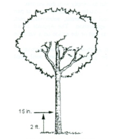
- Applicability of Landscaping and Screening Standards:
- Landscaping: Consistent with the objectives established in section 1111.06(a), landscaping shall be provided in the following areas:
- At the perimeter of sites to buffer, separate and/or screen adjacent land uses;
- At the perimeter of parking lots to shade, separate and/or screen the view of parked cars from adjacent residential uses;
- In the interior of parking lots to shade and beautify the paved surface; and
- Around the perimeter of buildings to soften, shade and enhance the appearance of structures.
- Screening: Screening shall be provided in the following areas:
- To block the view of trash dumpsters, loading areas, service courts and storage areas;
- Between residential and non-residential land uses;
- Parking lots shall be screened to minimize the view of cars from adjacent residential uses. It is not necessary to screen, but only to separate adjacent non-residential parking areas.
- Landscaping: Consistent with the objectives established in section 1111.06(a), landscaping shall be provided in the following areas:
- Procedure:
- Any person seeking a, subdivision plat approval, development plan approval or site plan approval, or any person seeking a variance or conditional use, if applicable, shall file with his application a landscaping plan prepared in a professional manner that, by plot plan and description, includes:
- The present location and size of all major trees, with a designation of major trees sought to be removed.
- The location, size and description of landscaping materials proposed to be placed on the lot in order to comply with this section.
- The location and size of any structures presently on the lot, and those proposed to be placed on the lot.
- The proposed location and description of screening proposed to be placed on the lot in order to comply with this section.
- The Planning Commission shall consider a landscape plan as part of its review of any conditional use permit, subdivision plat, development plan or site plan application. The Appeals Board shall consider a landscape plan as part of the action on a variance application.
- No variance, development plan approval, site plan approval or conditional use permit shall be granted or issued until final approval of the landscaping plan.
- Any person seeking a, subdivision plat approval, development plan approval or site plan approval, or any person seeking a variance or conditional use, if applicable, shall file with his application a landscaping plan prepared in a professional manner that, by plot plan and description, includes:
- Buffer Yards (Perimeter Lot Landscaping): The buffer yard is a designated unit of yard or open area together with any plant materials, barriers, or fences required thereon. Both the amount of land and the type and amount of landscaping specified are designated to lessen impacts between adjoining land uses. By using both distance and landscaping, the impact of such items as noise, glare, activity, dirt, and unsightly parking areas will be minimized. It is a further intent of the following provisions to provide flexibility to the property owner through the manipulation of four basic elements — distance, plant material type, plant material density, and structural or land forms.
- Location of buffer yards: Buffer yards shall be located on the side and rear lot lines of a parcel extending to the lot or parcel boundary line. Buffer Yards shall not extend into or be located within any portion of an existing street right-of-way.
- Determination of buffer yard requirements: To determine the type of buffer yard required between two adjacent parcels, the following procedure shall be followed:
- Identify the land use class of the proposed use by referring to Table 1111.06-1.
- Identify the land use class of each adjacent use by referring to Table 1111.06-2.
- Determine the buffer yard requirements for those side and rear lot lines or portion thereof on the subject parcel (i.e., the proposed use) by referring to Table 1111.06-3. Existing plant material or fences may be counted as contributing to the total buffer yard requirement. The buffer yards specified are to be provided on each lot or parcel of the proposed use, independent of adjacent uses or adjacent buffer yards.
- Should a developed use increase in intensity from a given land use class to a higher one on Table 1111.06-1 or Table 1111.06-2 (e.g., Class III to Class IV), the Planning Commission shall, during the site plan or development plan review process, determine if additional buffer yard is needed and, if so, to what extent and type.
- Buffer yard requirements are stated in terms of the width of the buffer yard and the number of plant units required per one hundred linear feet (100') of buffer yard. The requirements may be satisfied by any of the options indicated in Table 1111.06-3.
- Buffer yard requirements for nonconforming structures or sites: If a nonconforming site is unable to comply with the minimum buffer yard requirements of this Section, the applicant shall not be entitled to the permit for which application has been made unless a variance is granted. Existing paved parking areas beyond the minimum UDO requirements for number of spaces, maneuvering/access aisles or loading areas, as outlined in section 1111.07, shall be removed if necessary to provide the required buffer.
TABLE 1111.06-1: Land Use ClassificationClass I: Light Residential Agriculture Single-Family Detached Dwellings Two-Family Dwellings Class II: Office/Institutional Administrative and Business Offices Professional Offices Institutions - religious, social, cultural, educational, health and public Multi-Family Dwellings Class III: Commercial General Retail, Entertainment, Restaurants, Specialty Retail and Business Services Class IV: Industrial Manufacturing, Wholesaling, Research and Development Facilities
TABLE 1111.06-2: Buffer Yard Requirements
* No buffer yard required.Proposed Land Use Class Adjacent Existing Land Use Class I II III IV I * * * * II E A C D III E C A B IV E D B A
(A, B, C, D and E indicate the required type of buffer yard, as shown on Table 3)
TABLE 1111.06-3: Buffer Yard Types: Quantity Of Plant Material
1 Required number of minimum plant units per 100'.Buffer Yard Width Deciduous Trees1 Deciduous Shrubs1 Evergreens1 Berm2 Fence2 A 15' 2 — 2 10' 2 2 2 B 20' 2 — 2 15' 2 2 2 10' 2 4 4 C 25' 2 2 2 20' 2 4 2 15' 3 4 4 D 30' 2 2 2 25' 2 2 4 20' 3 4 4 * 10' 3 4 4 * E 30' 2 2 2 25' 3 4 4 20' 3 4 4 * 15' 3 4 4 *
2 Entire length of buffer yard, 3'-4' berm or 4'-6' opaque fence.
* Indicates berm or fence is required.
- Screening of Service Court, Storage Areas and Loading Dock Areas:
- For commercial, industrial, office-institutional and community service uses, all areas used for service, loading and unloading activities shall be screened along the entire rear lot line and side lot lines from the rear lot line to the building setback line, if adjacent to or abutting a residential district.
- Screening shall consist of walls, fences, natural vegetation or an acceptable combination of these elements, provided that screening must be at least seven feet (7'), and walls and fencing no more than twelve feet (12') in height. Natural vegetation shall be a variety which will attain seven feet in height within five years of planting.
- Natural vegetation screening shall have a minimum opaqueness of seventy-five percent (75%) at all times. The use of year-round vegetation, such as pines or evergreens is encouraged. Vegetation shall be planted no closer than three feet (3') to any property line.
Example of Acceptable Trash Container Screening
- Screening of Trash Container Receptacles:
- For commercial, community service, industrial, office-institutional and multiple family uses, all trash containers or receptacles shall be screened or enclosed. Trash containers designed to service more than one (1) residential unit or to service a non-residential structure shall be screened on all sides by walls, fences, or natural vegetation or an acceptable combination of these elements. Trash containers shall not be located in the front yard building setback and shall otherwise conform to the side and rear yard setbacks of the applicable zoning district.
- The height of such screening shall be at least six feet (6'). The maximum height of walls and fences shall not exceed ten feet (10'). Natural vegetation shall have a minimum opaqueness of seventy-five percent (75%) at all times. The use of year-round vegetation, such as pines or evergreens is encouraged. Natural vegetation shall be a variety which will attain six feet (6') in height within five (5) years of planting.
- Parking Lot Screening and Landscaping:
- Perimeter Screening. Effectively concealing vehicles within a parking area from the adjacent roadway or adjoining property requires the selective use of plant, mounding or fence material for visual separation. Located adjacent to the parking lot edge, the perimeter screening is designed to supplement required buffer yard material. The perimeter of parking areas, except those for single-family and two-family residential uses, shall be screened as follows:
- Parking areas for non-residential uses and for residential uses such as churches, schools, parks and public facilities adjacent to residentially zoned or used land shall be developed with plant, mounding or fence/wall material which conceals the view of parked cars from the residential property. The height of wall/fences located in front of the building line should be minimized with a maximum height of four feet (4'). Plant material should be used to soften and add visual interest to a wall/fence. A plant material screen shall have a minimum opaqueness of seventy-five percent (75%) at all times. The use of year round vegetation, such as pines or evergreens is encouraged.
- The separation and landscaping of the required buffer yard will provide adequate screening for all other parking lot perimeters.
- Interior Parking Area Landscaping: Landscaping within parking areas, whether ground cover or other upright plant material, is necessary not only to reduce the generation of heat and runoff, but to break up visually the expanse of paved areas. The use of parking islands or peninsulas strategically placed throughout the parking lot is one of the most effective ways to landscape parking lot interiors. The use of shade trees in these landscape areas is encouraged. Any open parking area (including loading areas) containing more than sixteen thousand square feet (16,000 sq. ft.) of area or fifty (50) or more parking spaces shall provide the following interior landscaping in addition to the required perimeter screening:
- For lots between sixteen thousand and twenty-nine thousand nine hundred ninety-nine square feet (16,000-29,999 sq. ft.), the landscaped area shall equal five percent (5%). For lots larger than thirty thousand square feet (30,000), the landscaped area shall be ten percent (10%).
- Whenever possible, large parking areas of thirty thousand square feet (30,000 sq. ft.) or larger shall be designed so as to break up their visual expanse and create the appearance of smaller parking lots. This distinction or separation can be achieved by interspersing yard space and buildings in strategic areas and by taking advantage of natural features such as slope, existing woodland or vegetation, drainage courses and retention areas.
- Landscaping in parking areas shall be dispersed throughout in peninsulas or islands. Minimum island or peninsula size shall be two-hundred square feet (200 sq. ft.), with a two foot (2') minimum distance between all trees or shrubs and the edge of pavement where vehicles overhang and a minimum width of ten feet (10').
- The Planning Commission, as part of the site plan review process, may vary the requirements for minimum and maximum size of parking islands and peninsulas if situations including, but not limited to the following, exist:
- The need to concentrate landscape areas for the purpose of stormwater detention;
- The need to relocate required landscaping on the perimeter of a parking area in the case of a small or unusually shaped lot or where additional screening is desired.
- Required plant materials for the interior of parking areas.
- One (1) deciduous tree shall be required for every three thousand square feet (3,000 sq. ft.) of parking area or for every ten (10) parking spaces.
- Where site distance or maneuvering conflicts exist, trees shall have a clear trunk of at least five feet (5') above the ground, and the remaining required landscape areas shall be planted with shrubs or groundcover not to exceed two feet in height.
- Perimeter Screening. Effectively concealing vehicles within a parking area from the adjacent roadway or adjoining property requires the selective use of plant, mounding or fence material for visual separation. Located adjacent to the parking lot edge, the perimeter screening is designed to supplement required buffer yard material. The perimeter of parking areas, except those for single-family and two-family residential uses, shall be screened as follows:
- General Landscaping For Lots and Building Foundations for Multi-Family, Commercial and/or Industrial Development (Not applicable to single-family homes): To visually soften the building mass or help define exterior spaces, the following landscaping shall be required for all lots, in addition to the landscaping for buffer yards and parking areas. All required planting shall be located in areas which do not include any buffer yard or right-of-way. If the lot consists primarily of impervious surfaces, such trees may be placed close to the building or may be used to add to required parking area landscaping. Existing plant materials which meet the requirements of this Section may be counted as contributing to the landscaping required by this Section.
- Lot Interior Landscaping: Three (3) deciduous trees shall be required for each one-hundred linear feet (100') of building perimeter of non-residential uses or per dwelling unit of single-family residential uses and one (1) deciduous tree for each multi-family unit.
- Building Foundation Planting Requirements: Foundation plantings are intended to soften building edges and screen foundations, and shall be placed within five feet (5') of the building perimeter if feasible. If the City Engineer determines that, because of site design considerations such as the location of sidewalks, plazas or service areas, this is not feasible, such plant materials may be located in planter boxes or in other areas of the site in a manner that enhances the overall landscape plan for the development.
- Five (5) shrubs shall be required per dwelling unit.
- Foundation shrubbery for non-residential uses shall be used to enhance and highlight building architecture. The use of foundation plantings is particularly important on blank walls (i.e. to window or door openings).
- Ten (10) shrubs shall be required for every one-hundred linear feet (100') of building perimeter for non-residential uses.
- Plant Material Specifications (For Buffer Yards, Landscaping and Screening): The following sections include specifications for plant materials. Alternatives to these materials which can be demonstrated to meet both the intent and requirements of this ordinance may be approved as part of a Landscape Plan.
- Deciduous Trees - Size at Planting: A minimum caliper of at least two and one-half inches (2.5") measured twenty-four inches (24") above ground level.
- Evergreen Trees - Size at Planting: A minimum of five feet (5') high and a minimum spread of three feet (3') .
- Shrubs: Shrubs shall be at least twenty-four inches (24") average height and spread at the time of planting and, where required for screening, shall form a continuous, year-round solid visual screen within five (5) years after planting.
- Groundcover and Grass:
- Groundcover - Groundcover shall be planted a minimum of eight inches (8") on center and shall be planted in such a manner so as to present a finished appearance and seventy-five percent (75%) coverage after one complete growing season. If approved as part of a Landscape Plan, groundcover may also consist of rocks, pebbles, sand, wood chips and other material.
- Grass - Grass shall be planted in species normally grown as permanent lawns in Franklin, Ohio, and may be sodded or seeded, except in swales or other areas subject to erosion, where solid sod, erosion-reducing net, or suitable mulch shall be used. Grass sod shall be clean and free of weeds and noxious pests or disease.
- Modifications and Conditions: The quantity of required plant material may be modified by the Planning Commission or by the Appeals Board when the Board determines that special conditions exist making either more or less plant material necessary.
- Maintenance and Replacement Requirements: The owner shall be responsible for the maintenance of all landscaping in good condition so as to present a healthy, neat and orderly appearance. This should be accomplished by the following standards:
- All plant growth in landscaped areas shall be controlled by pruning, trimming or other suitable methods so that plant materials do not interfere with public utilities, restrict pedestrian or vehicular access, or otherwise constitute a traffic hazard.
- All planted areas shall be maintained in a relatively weed-free condition, clear of undergrowth and free from refuse and debris.
- All trees, shrubs, ground covers and other plant materials contained on a Landscape Plan approved by the Planning Commission or Appeals Board must be replaced if they die or become unhealthy because of accidents, drainage problems, disease or other causes. Replacement plants shall conform to the size standards that govern original installation. Deciduous trees must be replaced with deciduous trees, coniferous trees must be placed with coniferous trees and shrubbery must be replaced with shrubbery. Plants intended for screening must maintain the required minimum opacity. Dead or unhealthy plants shall be replaced within the next planting season.
(Ord. 2009-14. Passed 7-6-09.)
- Purpose: The purpose of these requirements for off-street parking and loading facilities is to promote the orderly development of land within the City and to promote the safety of residents of the City by assuring the orderly handling of vehicles and vehicular traffic.
- General Specifications and Requirements:
- Applicability: In all districts, at any time any building, structure or use is constructed, enlarged, increased in capacity, used or occupied, including change of occupancy, there shall be provided for every use off-street parking spaces for automobiles in accordance with the provisions of this section. A Parking Plan shall be required for all uses except for single or two-family residential uses. The Parking Plan shall be submitted to Planning Commission as part of the Site Plan or Development Plan review process and to the Zoning Official as a part of the application for a Zoning Certificate. The Plan shall show the boundaries of the property, parking spaces, access driveways, circulation patterns, drainage plans and perimeter screening/landscaping, as appropriate.
- Minimum Area and Dimension Requirements: Parking spaces shall conform to the following minimum area and dimensions, exclusive of driveways and aisles, as shown on Table 1111.07-1.
- Compact Car Spaces: Excess parking spaces above the minimum required by this chapter may be designed to accommodate small cars for uses having little turnover such as apartments, general business offices or industrial plants. Commercial uses, medical offices and other high turnover uses are not permitted to designate small car spaces. The minimum width and length of such spaces shall be 8' x 17'. Approved small car spaces shall be grouped and clearly marked rather than scattered throughout the lot.
- Access: Each site shall have an access drive into the parking area with a minimum width as shown on Table 1111.07-2. All parking spaces, except those required for single- or two-family dwellings, shall have access to a public street or alley in such a manner that any vehicle leaving or entering the parking area from or into a public street or alley shall be traveling in a forward motion.
- Parking Aisles: Parking aisles adjacent to parking spaces shall contain the minimum widths shown on Table 1111.07-3.
TABLE 1111.07-1: Parking Space DimensionsParking Pattern Minimum Width (Feet) Minimum Length (Feet) Ninety degree (90°) angle parking 9 19 Sixty degree (60°) angle parking 9 19 Forty-five (45°) degree angle parking 9 19 Parallel parking 9 23
TABLE 1111.07-2: Driveway WidthParking Pattern Minimum Driveway Width (Feet) Single Family 10 Two-family 16 (combined drive) All other uses 12 (one way) 20 (two way)
TABLE 1111.07-3: Parking Aisle WidthParking Pattern Minimum Aisle Width (feet) Ninety degree (90°) angle parking 24 Sixty degree (60°) angle parking 18 (one way) Forty-five degree (45°) angle parking 12 (one way) 22 (two way) Parallel 12 (one way) 22 (two way)
- Location of Parking Spaces:
- Parking spaces for single- and two-family residential uses shall be located on the same lot as the use which is to be served.
- Parking in residential areas shall not be located off of the driveway in the front yard or side yard, except when such areas meet setback regulations and are paved with a hard or semi-hard, dust-free surface, as approved by the City Engineer.
- Except as permitted in the Downtown Districts, and in the instance of joint parking facilities authorized by section 1111.07(g), parking spaces for all nonresidential uses shall be located on the same lot as the use which is to be served.
- Parking for uses in the Commercial and Office Districts shall be located in the rear or side yards, unless parking in the front yard is approved by Planning Commission.
- Parking spaces for multiple family uses or similar residential uses shall be located not more than 250 feet from the principal use served.
- All land designated within the (DC-1) Downtown Core, (MU-1) Mixed Use, and the (RMU) Riverfront Mixed Use Districts, as identified on the Official Zoning District Map, is exempt from all off-street parking requirements.
- Required Improvements for Parking Areas:
- Paving Requirements:
- All off-street parking and loading areas including spaces, driveways, aisles, circulation drives, and other vehicular maneuvering areas shall be paved with blacktop, concrete, or pavers and shall be adequately drained, except for:
- Permitted uses located in the Agricultural District.
- All new driveways shall require an accessory use permit.
- All off-street parking and loading areas including spaces, driveways, aisles, circulation drives, and other vehicular maneuvering areas shall be paved with blacktop, concrete, or pavers and shall be adequately drained, except for:
- Lighting Requirements:
- Applicability: All off-street parking and loading areas including spaces, driveways, aisles, circulation, and other vehicle maneuvering areas shall be lighted except for:
- Permitted uses located in the Agricultural District.
- Driveways behind the front yard building setback in the single family and two-family residential districts.
- Type: All lighting shall be "full cut-off type" lighting and shall be arranged to reflect the light away from adjoining property.
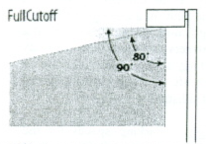
- Height:
- Freestanding lights with full cut-off fixtures shall not exceed a maximum height of 24 feet above grade.
- Illumination. The maximum illumination permitted at the property line shall be as shown in Table 1107.07-4: Illumination Levels.
- For any property which abuts an agricultural or residential district, or abuts property used for single family or two-family uses, the maximum level at the property line shall be 0.0 footcandles.
TABLE 1111.07-4: Illumination LevelsZoning District Maximum Illumination Level at the Property Line Agriculture, Residential, and Parks and Recreation Districts 0.0 footcandles Commercial, Downtown, Office, and Industrial Districts 0.50 footcandles
- For any property which abuts an agricultural or residential district, or abuts property used for single family or two-family uses, the maximum level at the property line shall be 0.0 footcandles.
Full Cut-Off Allows No light at or above 90 degrees 0% 100 cd per 1000 lamp lumens at or above 80 degrees 10% - Applicability: All off-street parking and loading areas including spaces, driveways, aisles, circulation, and other vehicle maneuvering areas shall be lighted except for:
- Paving Requirements:
- Maintenance for Required Improvements:
- The owner of a lot used for parking and loading shall maintain the parking area in good condition to be free of holes, trash and debris. The demarcation of parking spaces shall be adequately maintained either through periodic re-striping or other means.
- All lighting shall be maintained in good condition and working order and shall be illuminated between dusk and dawn.
- Traffic Control Devices:
- Entrances, exits and directional signs shall be provided where practicable, and signs shall conform to City sign regulations, outlined in section 1111.08.
- All parking areas having a capacity in excess of 10 vehicles shall be striped.
- When a parking area extends to a property line, or where the extension of a vehicle beyond the front line of the parking space would interfere with drive or aisle access, wheel blocks or other devices shall be used to prevent such extension.
- Determination of Required Spaces: In computing the number of parking spaces required by this section, the following rules shall apply:
- Where gross floor area is designated as the standard for determining parking space requirements, floor area shall be the sum of the gross horizontal area of all the floors of a non-residential building measured from the faces of the exterior walls.
- Where seating capacity is the standard for determining parking space requirements, the capacity shall mean the number of seating units installed or indicated or each 20 linear inches of benches, or pews, except where occupancy standards are set by the Ohio Building Code.
- Fractional numbers shall be increased to the next whole number.
- The parking space requirements for a use not specified in this Section shall be determined by the Appeals Board, on recommendation from the Zoning Official, if the use is substantially similar to another use for which a standard has been established.
- Joint or Collective Parking Facilities:
- Where two or more uses are provided on the same lot, the total number of spaces required shall equal or exceed the sum of the individual requirements, unless modified by Planning Commission. In computation, a fractional space shall be rounded to the next highest number.
- All required parking spaces shall be located on the same lot with the building or use served, except that where an increase in the number of spaces is required by a change or enlargement of use, or where such spaces are provided collectively or used jointly by two or more buildings or establishments, the required spaces may be located not farther than 250 feet from the building served.
- In any case where the required parking spaces are not located on the same lot with the building or use served, or where such spaces are collectively or jointly provided and used, a written agreement thereby assuring their retention for such purposes shall be properly drawn and executed by the parties concerned, approved as to form by the Director of Law, approved as to content by Planning Commission and filed with the application for a zoning certificate.
- Upon prior approval by the Planning Commission of the terms of a written agreement entered into by owners of property and the City providing for the joint use of parking spaces, two or more nonresidential uses may jointly provide and use parking spaces when their hours of operation do not substantially overlap.
- Parking Spaces for Handicapped Persons: Parking spaces for the handicapped shall meet the requirements of the Ohio Building Code and the Ohio Revised Code. Each such space may be included in the computation of required number of spaces by use.
- Required Number of Parking Spaces by Use: Parking spaces shall be provided according to the following schedule:
TABLE 1111.07-5: Required Number of Parking SpacesPrincipal Building or Use Minimum Spaces Required (Unless Specified Otherwise) Agricultural Uses Agriculture 1 space per employee on the largest shift plus 1 space per 10 employees Residential Uses Dwelling, Four Family 2 spaces per dwelling Dwelling, Live/Work 2 spaces per dwelling Dwelling, Multi-Family 5+ Units 1 space per dwelling plus 1 space per every 10 dwellings Dwelling, Row House 2 spaces per dwelling Dwelling, Single Family 2 spaces per dwelling Dwelling, Three Family 2 spaces per dwelling Dwelling, Two Family 2 spaces per dwelling Dwelling, Upper Floor 2 spaces per dwelling Elderly Housing 1 space per 6 beds plus 1 space per employee on the largest working shift Residential Facilities and Residential Treatment Facilities 1 space per every 4 residents, plus 1 space per employee on the largest working shift Public and Institutional Uses Alcohol and Drug Addiction Facilities 1 space per every 4 residents, plus 1 space per employee on the largest working shift Cemeteries N/A Educational Facilities (Pre-K through 12th Grade) 1 space per employee on the largest working shift plus 1 space per 5 students at maximum capacity Essential Services 1 space per 500 square feet of floor area Government Facilities 1 space per 500 square feet of floor area Mortuaries 1 space per 50 square feet of public floor area, 1 space per employee, plus 1 space per each business vehicle Public Parks, Open Spaces, Recreation, and Preserves, Outdoor Parking shall be provided as determined by the Planning Commission based on the submitted site plan Public Plazas, Gathering, Eating Areas N/A Public Recreation and Event Space, Indoor 1 space per 250 square feet of floor area plus 1 space per employee on the largest working shift Religious and Cultural Facilities 1 space per 4 seats at maximum capacity Secondary Education/Colleges/Universities 1 space per every 3 students plus 1 space per employee on the largest working shift Transportation or Communication Utility N/A Commercial Uses Alcohol Production and Sales 1 space per employee on the largest shift plus 1 space per 3 seats for any restaurant/taproom Assisted Living and Skilled Nursing Care 1 space per 6 beds plus 1 space per employee on the largest shift Automobile Fueling/Charging Stations 1 space per 500 square feet of floor area plus 1 space per employee on the largest working shift Automobile Sales/Rental 1 space per 800 square feet of floor area plus 1 space per 3,000 square feet of open lot area devoted to the sale and display of vehicles Automobile Service/Repair 2 spaces per service bay plus 1 space per employee on the largest working shift Automobile Washing Facility 1 space per employee on the largest working shift Bar, Lounge, Tavern 1 space per 100 square feet of seating area capacity plus 1 space per employee on the largest working shift Bed and Breakfast 2 spaces plus 1 space per employee Business Incubation 1 space per 300 square feet of floor area Business Retail 1 space per 200 square feet of floor area Business Service 1 space per 300 square feet of sales and office area, 1 space per employee on the largest working shift, plus 1 space per company or service vehicle regularly stored on the premises Clubs, Private or Membership 1 space per 50 square feet of floor area in assembly or meeting rooms plus 1 space per 200 square feet of other floor area Commercial Entertainment 1 space per 200 square feet of floor area Commercial Event Center 1 space per 3 guests plus 1 space per employee on the largest working shift Commercial Recreation/Fitness, Indoor 1 space per 250 square feet of floor area Commercial Recreation/Fitness, Outdoor Parking shall be provided as determined by the Planning Commission based on the submitted site plan Commercial Training 1 space per 3 students at maximum capacity plus 1 space per every employee on the largest working shift Day Care Center 1 space per employee on the largest working shift plus 1 space per every 5 at maximum capacity Event Venue, Indoor 1 space per 100 square feet of floor area Event Venue, Outdoor Parking shall be provided as determined by the Planning Commission based on the submitted site plan Environmental Sciences 1 space per employee on the largest working shift plus 1 space per 10 employees Farm Market 1 space per 250 square feet of floor area Financial Institution, General 1 space per 200 square feet of floor area plus 1 space per employee on the largest working shift Food Service/Catering 1 space per 250 square feet of floor area Hospitals 1 space per every 6 beds plus 1 space per employee on the largest working shift Hotels 1 space per guest room plus 1 space per employee on the largest working shift Information Technology/Data Centers 1 space per employee on the largest working shift plus 1 space per 10 employees Landing Fields N/A Makerspace 1 space per 250 square feet of floor area Medical Center/Clinic 3 spaces per treatment or examination room plus 1 space per employee on the largest working shift Medical Office 3 spaces per treatment or examination room plus 1 space per employee on the largest working shift Mixed Use The applicable parking regulations for the uses contained within the mixed use development, as dictated by this table Office 1 space per 300 square feet of floor area Office, Campus 1 space per 300 square feet of floor area Office, Co-Working 1 space per 300 square feet of floor area Personal Service 1 space per 200 square feet of floor area Restaurant, Quick Service 1 space per 50 square feet of seating area capacity plus 1 space per employee on the largest working shift Restaurant, Standard 1 space per 100 square feet of seating area capacity plus 1 space per employee on the largest working shift Retail, Convenience 1 space per 400 square feet of floor area Retail, Food/Beverage Related 1 space per 500 square feet of floor area Retail, General 1 space per 500 square feet of floor area Retail, Large Format 1 space per 500 square feet of floor area Retail, Secondhand 1 space per 500 square feet of floor area Retail, Services 1 space per employee on the largest working shift plus 1 space per 10 employees Retreat Center 1 space per 3 guests plus 1 space per employee on the largest working shift Sexually Oriented Businesses 1 space per 500 square feet of floor area Skilled Nursing Facility 1 space per 6 beds plus 1 space per employee on the largest working shift Veterinary Services 3 spaces per treatment area plus 1 space per employee on the largest working shift Industrial Uses All industrial Uses 1 space per employee on the largest working shift plus 1 space per 10 employees - Modifications: The Zoning Official may modify the requirements in Table 1111.07-5: Required Number of Parking Spaces if it is deemed appropriate based on the parking demand of the proposed use, number of typical patrons or employees, shared parking, off-street parking, alternative transportation , or other similar reasons. As part of the approval for a reduction in the number of required parking spaces, the approving body may require the applicant to reserve land on the subject property to be reserved for a future parking area.
- Administrative Approvals: The Zoning Official may approve a reduction in the number of required parking spaces, up to 25 percent for the reasons listed above.
- Board of Zoning Appeals Approvals: If an applicant requests a reduction of more than 25 percent of the required number of parking spaces, that request will be subject to the decision of the Board of Zoning Appeals.
- Required Number of Stacking Spaces:
- Applicability: Establishments which by their nature create lines of customers waiting to be served within automobiles shall provide stacking spaces that are on the same lot as the use, in addition to the required number of parking spaces per Table 1111.07-5: Required Number of Parking Spaces. The required stacking spaces shall not extend into or be within the public right-of-way, access drives, or circulation areas. Stacking spaces shall meet the requirements set forth in the following table.
TABLE 1111.07-6: Required Number of Stacking SpacesActivity Minimum Number of Required Stacking Spaces Measured From Automobile Washing Facility, Automatic 6 per lane Entrance Automobile Washing Facility, Self-Service 3 per lane Entrance Automobile Fueling Station 2 per fuel pump Pump Island Day Care Center 8 for facilities with 20 or fewer clients plus one additional stacking space for each additional 10 clients served Entrance Financial Institution or ATM 4 Teller, Window, or ATM Food and Beverage Use with Drive-Thru or Pick-Up Window 7 Pick-up Window Other Minimum of 2 per window - Dimensions: Each stacking space shall have an arear not less than 160 square feet (measured eight feet by 20 feet) exclusive of access drives and parking aisles.
- Location: Stacking spaces may not impede on-site or off-site traffic movements or movements into or out of off-street parking spaces. Stacking spaces shall also provide for safe pedestrian crossings to and from parking spaces and the building.
- Modifications: The Planning Commission may require additional stacking spaces than specified in this section for uses that have extremely high-demand use periods that cause long waiting lines, such as fast food restaurants or drive-through coffee shops. In such cases, the Zoning Official shall work with the applicant to ensure that the site plan can accommodate the anticipated intensity of demand and forward a recommendation to the Planning Commission
- Applicability: Establishments which by their nature create lines of customers waiting to be served within automobiles shall provide stacking spaces that are on the same lot as the use, in addition to the required number of parking spaces per Table 1111.07-5: Required Number of Parking Spaces. The required stacking spaces shall not extend into or be within the public right-of-way, access drives, or circulation areas. Stacking spaces shall meet the requirements set forth in the following table.
- Required Number of Loading Spaces by Use:
- Whenever the normal operation of any development requires that goods, merchandise, or equipment be routinely delivered to or shipped from that development, a sufficient off-street loading and unloading area must be provided in accordance with this Section to accommodate the delivery or shipment operations in a safe and convenient manner.
- Loading spaces shall conform to the following minimum dimensions:
- Type A space - (for semi truck vehicles) 14 feet minimum width, 55 feet minimum length, 15 feet height clearance. The space shall not inhibit service access to neighboring facilities or loading areas.
- Type B space - 12 feet minimum width, 30 feet minimum length, 15 feet height clearance, and arranged so as not to inhibit other service traffic.
- The number of loading spaces required are outlined in Table 1111.07-7 and Table 1111.07-8.
- Loading and unloading areas shall be so located and designed that the vehicles intended to use them can maneuver safely and conveniently to and from a public right-of-way, and complete the loading and unloading operations without obstructing or interfering with any public right-of-way or any parking space or parking lot aisle.
- No area allocated to loading and unloading facilities may be used to satisfy the area requirements for off-street parking, nor shall any portion of any off-street parking area be used to satisfy the area requirements for loading and unloading facilities.
- Whenever there exists a lot with one or more structures constructed before the effective date of this chapter, and a change in use that does not involve any enlargement of a structure is proposed for such lot, and the loading area requirements of this Section cannot be satisfied because there is not sufficient area available on the lot that can practicably be used for loading and unloading, the Planning Commission may modify or waive these requirements.
- A loading space may occupy all or any part of any required side or rear yard. No loading or unloading shall occur in a front yard, except for structures less than 15,000 square feetft.).
- No loading space shall be located closer than 50 feet to any residential district.
- Short term storage of pod units shall be situated on a durable, impervious surface, such as a driveway, and located within the building setback. No pod unit shall be permitted to remain longer than seven days. Units located within a commercial district shall, in addition to these standards, be located in the rear yard and screened from view by opaque landscape material or fencing.
TABLE 1111.0-7: Commercial and Industrial BuildingsGross Floor Area Number and Type of Loading Space Less than 5,000 sq. ft. 0 Equal to or greater than 5,000 sq. ft. but less than 15,000 sq. ft. One Type B Equal to or greater than 15,000 sq. ft. but less than 30,000 sq. ft. One Type A Equal to or greater than 30,000 sq. ft. One Type A and B For each additional 50,000 sq. ft. or fraction thereof One Type A
TABLE 1111.07-821: Office and Institutional Buildings (Excluding Churches)Gross Floor Area Number and Type of Loading Space Less than 20,000 sq. ft. 0 Equal to or greater than 20,000 sq. ft. but less than 100,000 sq ft. One Type A Equal to or greater than 100,000 sq. ft. but less than 350,000 sq. ft. Two Type A 350,000 sq. ft. or more Two Type A plus one for each additional 300,000 sq. ft. or fraction thereof
- Modifications and Conditions:
- Where the Planning Commission finds that strict compliance with the minimum improvement requirements provided for in this chapter results in extraordinary hardship or costs being imposed upon a particular subdivision, PUD, PRCD or other development, it may vary these improvement regulations so that substantial justice may be done and the public interest secured.
- In granting modifications of these Requirements, the Planning Commission may require such conditions as will, in its judgment, secure the objectives of the standards of requirements so varied or modified.
((Ord. 2009-14. Passed 7-6-09; Ord. 2010-22. Passed 12-6-10.)
Amended by Ord. 2023-01 on 3/7/2023
Amended by Ord. 2025-03 on 2/3/2025
Amended by Ord. 2025-02 on 2/3/2025
Amended by Ord. 2025-13 on 6/16/2025
- Purpose and Intent: It is the intent of this Section to establish reasonable regulations governing the size, design, mass, distribution, and location of signs within the incorporated area of the City of Franklin, in the interest of safety and general welfare of its citizens, business concerns, and other affected sectors of the City. It is intended to protect property values, create a more attractive economic and business climate, enhance and protect the physical appearance of the City, and preserve the scenic and natural beauty of designated areas. It is further intended to reduce sign distractions and sight obstructions that may contribute to traffic accidents, reduce hazards that may be caused by signs overhanging or projecting over public rights-of-way, provide more open space, and curb the deterioration of the natural environment and enhance City development in such a way as to support and complement the land-use objectives set forth in this UDO. The specific public purposes of this Section are:
- To provide reasonable, yet appropriate, conditions for identifying goods sold or produced or services rendered in Commercial, Downtown, Office/Institutional, and Industrial Districts;
- To control the size, location, and design of permanent signs so that the appearance of such signs will be aesthetically harmonious with their surroundings;
- To eliminate any conflict that would be hazardous between business or identification signs and traffic control signs and devices;
- To ensure that signs are located and designed to maintain a safe and orderly pedestrian and vehicular environment; and
- To reduce sign clutter.
- Scope of Regulations:
- Applicability: The regulations set forth herein shall apply to and govern signs in all districts. No sign shall be erected or maintained unless it is in compliance with the regulations governing location and bulk of structures for the district in which it is located, unless such sign is otherwise specifically regulated by a conditional use provision or provisions relating to variances.
- Nonconformities: Any sign already established on the effective date of this UDO and which sign is rendered nonconforming by the provisions herein, and any sign which as a result of subsequent amendments hereto, shall be rendered nonconforming and shall be subject to the regulations of section 1111.08(m).
- Variances: Variances to this Section may be considered by the Appeals Board.
- Planned Unit Developments: Signs within Planned Unit Development (PUD) districts shall be subject to the applicable regulations of the underlying zoning district. Signs that do not meet the requirements of this section that are located within a PUD are subject to the approval of the Planning Commission.
- Permit Required:
- All permanent signs to be erected, placed, constructed or modified within the City limits, except those specifically excluded herein, shall require a permit before work is initiated. Temporary sign permit requirements are established in Section 1111.08(l).
- Sign permits shall be reviewed and approved by the Zoning Official, unless specifically stated otherwise.
- Submittal Requirements:
- General Submittal Requirements: The following general requirements shall apply:
- Each request for a Sign Permit shall include an application form, provided by the City, with the submittal;
- The name(s), address(s), and telephone numbers of the applicant(s), and the property owner(s) if other than the applicant(s) with a notarized letter of authorization from the property owner;
- Legal Description of property or portion thereof; and
- Payment of the application fee as established on the City's official fee schedule;
- The Zoning Official may request additional supporting information that in their professional judgment is necessary to fully explain the applicant's proposal. The applicant shall supply the requested additional information.
- Only complete applications shall be processed by the City. The Zoning Official or the TRC, as appropriate, shall make determination as to completeness.
- Site Plan, which shall show:
- Address and zoning classification of the subject property;
- Surrounding uses and zoning classification(s);
- The proposed sign(s) location, including distance from the public right-of-way and the property lines;
- The location of all other existing signs located on the same premises;
- The relationship of the proposed sign(s) to access drives, parking areas and buildings;
- A landscape plan that identifies all plantings to be located at the base of any ground signs; and
- A lighting plan for all internal and external light sources.
- A Sign Graphics Plan, including:
- Plans, drawn to scale, of the proposed signage, including details of fastenings, lighting and any lettering, symbols or other identification which will be on the sign;
- The dimensions, construction supports, sizes, electrical wiring and components, sign materials, and method of attachment;
- The location, size, and illumination of wall signs, ground mounted signs, and directional signs;
- Color renditions of the proposed signage; and
- Elevation drawings of ground mounted signs and/or a façade elevation (showing the height and proportions) for wall signs.
- General Submittal Requirements: The following general requirements shall apply:
- Administration:
- The Zoning Official shall regulate and enforce the requirements of this Section and shall be in charge of issuing all sign permits, both temporary and permanent unless specifically identified otherwise.
- No signs, except for municipally owned signs and signs authorized by the City Manager for community events and programs shall be placed in, on or above the public right-of-way including on utility poles. The Zoning Official or their designee may remove any sign illegally placed within the right-of-way of any road within the City.
- Measurement:
- Sign area shall include the face of all the display area of the sign not including the bracing, framing and structural supports of the sign, unless such support members are made part of the message or face of the sign or are determined by the Zoning Official to be intended solely to make the sign more visible rather than serving any aesthetic or structural purpose. For internally illuminated signs; or internally illuminated awnings, canopies or marquees, the entire lighted surface shall be considered the sign area. The lighted surface area of internally illuminated canopies, awnings or marquees is counted as signage regardless of whether it contains graphics.
- Where a sign has two or more display faces, the area of all faces of the sign shall be included in determining the area of the sign unless two display faces join back to back, are parallel to each other and not more than 24 inches apart, or form a V-angle of less than 45 degrees. For spherical signs, the sphere shall be dissected by an imaginary line through the center of the sphere and the surface area of the half sphere shall be counted as the sign face. For cubical signs, the area of all display faces shall be included in determining the area of the sign.
- The area of letters, numbers or emblems mounted on a building wall or wall extension shall be computed by enclosing such sign with the smallest single continuous perimeter around the letters, numbers or emblems and determining its area.
- The term “lot frontage” as used in calculating ground signs and monument signs shall refer to the dimension of the lot along the street. The term “building frontage” as used in calculating wall signs shall refer to the building wall dimension facing the street or parking lot.
- For structures and uses having no direct frontage on public roads, as within shopping centers, frontage shall be counted as the intersection of the building line onto adjacent drives or parking areas.
- Prohibited Signs: The following signs are prohibited within the City of Franklin:
- Billboards;
- Pole signs, except within the Highway Sign Overlay District, under the conditions outlined in Section 1109.07.
- Roof signs;
- Revolving signs;
- Inflatable signs, air activated devices, beacons, searchlights, and other similar devices;
- No permanent sign or advertising device shall contain or consist of banners, ribbons, pennants, streamers, or similar moving devices;
- Bench signs;
- Mobile or portable signs; and
- Additional prohibited temporary signs as listed in Section 1111.08(l)(11).
- Exempt Signs: The following signs are exempt from the requirements of this Chapter:
- Governmental Flags: Flags of any country, state, or unit of local government.
- Organizational Flags: Flags for private or non-profit organizations subject to such flags are limited to one per organization and such flags shall not exceed three feet in width or five feet in length. Such flags shall contain no commercial or advertising message.
- Identification Signs: Signs up to a maximum of two square feet in size and may be mounted or attached flat or parallel onto a building face of any use or may be ground mounted at a height not to exceed four feet.
- Public: Signs required or authorized for a public purpose by any law, statute, or ordinance, such signs to include traffic control devices provided that such signs contain no supplementary advertising, and any identification of display or any official court or public office notices thereof, or any flag, emblem, or insignia of any country, political unit, educational facility, or religious/cultural group.
- Memorial Signs, Markers, and Statues: Signs which are in the nature of cornerstones, commemorative tables, tablets, grave markers, headstones, statuary, remembrances of persons or events, or historical signs, provided that such signs are less than nine feet in size, not illuminated, and are non-commercial in nature. Such signs shall not be placed within a public right-of-way. Additionally, memorial markers, statues, sculptures, or similar items that commemorate historical events, persons, or locations, are exempt as long as such items are not located in the public right-of-way and do not block visibility.
- Permanent Signs: All permanent signs shall require a permit. Permitted permanent signs shall be classified into one of the 11 following types: wall signs, ground signs, residential development identification signs, menu boards, canopy/marquee/awning signs, window signs, projecting signs, directional signs, murals, manual changeable copy signs, and electronic message centers.
TABLE 1111.08-1: Permitted Permanent SignsAgricultural and Residential Zoning Districts Office Districts, Parks and Recreation District Commercial Districts Industrial Districts Downtown Districts Wall Signs P P P P P Ground Signs P P P P P Residential Development Identification Signs P Menu Boards P Canopy/Marquee/Awning Signs P P P P Window Signs P P P P Projecting Signs P P P Directional Signs P P P P P Murals P P P P Manual Changeable Copy Signs P P P P Electronic Message Centers P
P=Permitted Sign- Wall Signs
- Wall signs may be erected on a building wall or extension of a building wall which faces a street, parking lot, or service drive, and such signs may not extend more than 10 inches beyond any building setback lines.
- Wall signs shall be attached parallel to the building face and extend outward perpendicular from the building face a maximum of 10 inches, except as otherwise provided herein.
- Wall signs shall be primarily constructed out of channel cut letters or other high-quality sign construction types, as determined by the Zoning Official. Logos and graphic elements may also be incorporated into the sign as accent features.
- There is no limit to the quantity of wall signs as long as the cumulative square footage of all wall signs meets the maximum area requirements. The sign area of any proposed canopy, marquee, or permanent window signs shall be included in the overall cumulative calculation of maximum wall signage area.
TABLE 1111.08-2: Wall Sign RegulationsDistrict/Use Maximum Area Illumination/Other Nonresidential Uses Located in Agricultural and Residential Districts 2 square feet per lineal foot of building frontage (maximum 150 square feet) Externally illumination permitted Office Districts/Parks and Recreation District 2 square feet per lineal foot of building frontage (maximum 200 square feet) Internally or externally illumination permitted Commercial Districts 2 square feet per lineal foot of building frontage (maximum 250 square feet) Internally or externally illumination permitted Industrial Districts 2 square feet per lineal foot of building frontage (maximum 300 square feet) Internally or externally illumination permitted Downtown Districts (Downtown Core, Mixed Use, Riverfront Mixed Use)** 2 square feet per lineal foot of building frontage (maximum 250 square feet) Internally or externally illumination permitted. Cabinet wall signs are prohibited. Downtown Districts (Civic) 2 square feet per lineal foot of building frontage (maximum 200 square feet) Internally or externally illumination permitted **In the Transitional Neighborhood Downtown District wall signs are limited to Identification Signs
- Ground Signs
- Ground signs must be located on the same parcel to which they are an accessory use. Off-premises advertising is not permitted on ground signs.
- Ground signs may include a variety of designs including monument signs, post and panel signs, and other similar-type professionally designed signs. Ground signs do not include pole signs.
- No ground sign shall be erected so as to obstruct free access or egress from any building.
- Inside the fire limits, no ground sign shall be constructed of combustible materials, except ornamental features. Outside the fire limits, the structural frame of ground signs shall not be erected out of combustible materials.
- No person shall place or cause to be placed any ground sign within any right-of-way or within the clear sight triangle.
- Ground signs shall be anchored to a minimum depth of 32 inches.
- The base of all new ground signs shall be effectively landscaped with a single, continuous landscaped area to be maintained beneath the sign, in accordance with the following standards:
- The minimum size of the landscaped area shall be equal to the area of the ground sign (i.e., if a ground sign is proposed to be 40 square feet in size then it shall be located in a landscaped area of at least 40 square feet in size);
- The landscaped area shall include all points where sign structural supports attach to the ground;
- Where the required landscaped area adjoins a paved surface accessible to vehicular traffic, a raised planter-type area around the base of the sign is required to prevent the encroachment of vehicles; and
- The landscaped area shall include living plantings aesthetically located and maintained including flowers, shrubs, and grasses. Plants may be located in mulch beds, but the landscaped area may not be completely comprised of mulch. The use of concrete, asphalt, gravel, or any other paved surface, or hardscape in the landscaped area shall be prohibited.
TABLE 1111.08-3: Ground Sign RegulationsDistrict/Use Quantity Maximum Area Maximum Height Minimum Setbacks Illumination/Other Agricultural and Nonresidential Uses Located in Residential Districts 1 per street frontage 0.25 square feet per foot of road frontage (maximum 36 square feet) 6 feet 10 feet from right-of-way, 15 feet from side property lines, 5 feet from all driveways External illumination permitted Office Districts/Parks and Recreation District 1 per street frontage 0.25 square feet per foot of road frontage (maximum 36 square feet) 6 feet 10 feet from right-of-way, 15 feet from side property lines, 5 feet from all driveways Internally or externally illumination permitted Commercial Districts 1 per street frontage 0.5 square feet per foot of road frontage (maximum 64 square feet) 6 feet 10 feet from right-of-way, 15 feet from side property lines, 5 feet from all driveways Internally or externally illumination permitted Commercial Districts (multi-tenant developments or single users of 50,000 square feet or more) 1 per street frontage 0.5 square feet per foot of road frontage (maximum 100 square feet) 10 feet 10 feet from right-of-way, 15 feet from side property lines, 5 feet from all driveways Internally or externally illumination permitted Industrial Districts 1 per street frontage 1 square feet per foot of road frontage 8 feet 10 feet from right-of-way, 15 feet from side property lines, 5 feet from all driveways Internally or externally illumination permitted Downtown Districts** 1 per street frontage 0.25 square feet per foot of road frontage (maximum 36 square feet) 6 feet Must be located on private property and 5 feet from all driveways and side property lines External illumination only **In the Transitional Neighborhood Downtown District ground signs are not permitted
- Residential Development Identification Signs
- Ground signs may be erected at the entrance of any residential subdivision or residential development. The location, height, and other characteristics of the sign must meet the regulations of this section.
- Two ground signs are permitted per each street entrance (one sign is permitted on each side of the entrance to the subdivision or development). Ground signs shall be permanently and securely anchored to the ground and shall be flush mounted to a base, which shall be of brick, stone, or a faux alternative. Alternate ground sign designs may be presented to the Planning Commission for review and approval. Pole type signage is prohibited.
- The sign area shall be limited to 24 square feet and shall not exceed four feet in height.
- The sign area may be incorporated into a larger design features that may include columns, walls, or other similar features. The reverse sides of identification features shall be finished to match the fronts.
- Such identification features may not be located in the public right-of-way. Under no circumstances shall such feature be located in the tree lawn nor the clear sight triangle, nor impair the future utilization or expansion of public streets.
- Applications for permanent subdivision identification signs must demonstrate provisions for future maintenance and maintenance easements at the time of final platting. Written consent of the property owner of each proposed sign location shall be submitted with each permit application.
TABLE 1111.08-4: Residential Development Identification Sign RegulationsDistrict/Use Quantity Maximum Area Maximum Height Minimum Setbacks Illumination/Other Agricultural and Residential Zoning Districts 2 per street entrance into the subdivision 24 square feet 4 feet 10 feet from right-of-way External illumination permitted
- Menu Boards: Menu Boards provided such signs are oriented solely for the use of patrons utilizing the drive-thru and are not visible from adjacent property or the right-of-way. Drive-through menu board signs may include freestanding, pylon, and monument signs. One drive-through menu board sign and one preview board is permitted, but only when all of the following conditions are fulfilled: the sign is located on the property to which it refers; the sign is not visible from the public right-of-way; the sign does not exceed six feet in height; and the sign is located at least 75 feet from a Residential District or use.
TABLE 1111.08-5: Menu Board Sign RegulationsDistrict/Use Quantity Maximum Area Maximum Height Minimum Setbacks Illumination/Other Commercial Districts (uses that include a permitted drive-through) 2 per drive-through 48 square feet 6 feet 75 feet from a Residential District or use Internally or externally illumination permitted - Canopy/Marquee/Awning Sign: Canopy, marquee, and awning signs may be painted on or attached to an awning area or attached to a canopy or marquee. Such signs shall not exceed the maximum height of the principal structure when mounted on the top of the canopy. The sign area of any proposed canopy or marquee sign shall be included in the overall cumulative calculation of allowable wall signage. Awning signs shall be externally illuminated only. Marquee and canopy signs may be internally or externally illuminated.
TABLE 1111.08-6: Canopy/Marquee/Awning Sign RegulationsDistrict/Use Maximum Area Illumination/Other Office Districts/Parks and Recreation District The area of all canopy/marquee/awning signs shall be included in the overall calculation of allowable wall signage Internally or externally illumination permitted Commercial Districts The area of all canopy/marquee/awning signs shall be included in the overall calculation of allowable wall signage Internally or externally illumination permitted Industrial Districts The area of all canopy/marquee/awning signs shall be included in the overall calculation of allowable wall signage Internally or externally illumination permitted Downtown Districts (Downtown Core, Mixed Use, Riverfront Mixed Use)** The area of all canopy/marquee/awning signs shall be included in the overall calculation of allowable wall signage Internally or externally illumination permitted. Cabinet wall signs are prohibited. Downtown Districts (Civic) The area of all canopy/marquee/awning signs shall be included in the overall calculation of allowable wall signage Internally or externally illumination permitted **In the Transitional Neighborhood Downtown District canopy/marquee/awning signs are not permitted - Window Signs: The cumulative maximum area of all permanent window signs shall be included in the overall calculation of allowable wall signage and are limited to windows on the ground or first floor. A maximum of 25 percent of each window may be covered by window signs. Political jurisdictions and educational facilities are exempted from this maximum area, and their window signage does not count towards the overall calculation of allowable wall signage. Window signs shall not be lighted or illuminated.
- Projecting Signs: One projecting sign is permitted per parcel. Projecting signs shall not exceed 12 square feet in size, shall be placed not less than eight feet above the sidewalk or ground level , and shall not project more than four feet outward from the building face. Projecting signs shall be externally illuminated only.
- Directional Signs: On-site directional signs indicating points of entry or exit for a facility, off-street parking areas, circulation patterns, business or building locations, or for other similar purposes are permitted subject to the following:
- Directional signs are limited to a maximum area of nine square feet and five feet in height.
- Directional signs shall not contain advertising or commercial messaging, including logos.
TABLE 1111.08-7: Directional Sign RegulationsDistrict/Use Quantity Maximum Area Maximum Height Minimum Setbacks Illumination/Other See Table 22: Permitted Permanent Signs N/A 9 square feet 5 feet 5 feet from the public right-of-way and all property lines External illumination permitted
- Directional signs are limited to a maximum area of nine square feet and five feet in height.
- Murals: Murals that contain no advertising or commercial messaging may be permitted on any blank wall or portion of a wall per the approval of the City Manager. Murals that contain advertising or commercial messaging may be permitted per the approval of the Planning Commission. The following factors shall be considered and weighed in determining whether a mural should be approved.
- Mural Location:
- Murals shall not be located on the principal facade(s) of a building unless approved by the Planning Commission.
- Murals should not cover or detract from architectural features.
- The installation of a mural should complement and enhance the building and be incorporated architecturally into the facade.
- Murals should not be in an area which may cause undue distraction to drivers, thereby creating a safety hazard.
- Mural Design and Materials:
- The scale of the mural should be appropriate to the building and the site.
- The theme of the mural should be appropriate within the context of the surrounding area and complement the existing character.
- The name of the artist or sponsor of the mural may be incorporated into the mural but shall not exceed five percent of the design or two square feet in area, whichever is less.
- The paint utilized for the mural should be intended for exterior use, have a waterproof seal coating, and of sufficient quality which will not corrode or compromise the integrity of the surface to which it is applied.
- Reflective, neon, and fluorescent paints should not be used.
- Mural Location:
- Manual Changeable Copy: The following regulations apply to all manual changeably copy:
- Manual changeable copy shall be permitted on ground signs.
- Manual changeable copy signs shall compromise no more than two-thirds (2/3) of the total area of the sign per side.
- Ground signs containing manual changeable copy are subject to the maximum height and sign area requirements of ground signs for the zoning district in which they are located.
- In the Residential Districts and the Downtown Districts, manual changeable copy signs shall not be internally illuminated. In these three districts, the manual changeable copy signs may be externally illuminated only between 8:00 a.m. and 8:00 p.m., unless otherwise permitted by Planning Commission.
- Electronic Message Centers: The following regulations apply to all electronic message centers:
- Electronic message centers may be incorporated into ground signs subject to the approval of a conditional use permit per Section 1115.09(b).
- Ground signs containing electronic message centers are subject to the maximum height and sign area requirements of ground signs for the zoning district in which they are located.
- Electronic message centers shall be located a minimum of 250 feet from any residential use.
- Electronic message centers shall only be located on ground mounted signs and shall not exceed two-thirds (2/3) of the size of the total sign area to ensure that the electronic component is subordinate to the principal sign face in size.
- A maximum of one electronic message center is permitted per parcel or development.
- Each message on an electronic message center shall be displayed for no less than eight seconds before transitioning.
- The use of streaming or full-motion video on any electronic message center is prohibited.
- The lighting within an electronic message center shall not be permitted to strobe, flash on or off, change the intensity of illumination, or illustrate movement.
- Electronic message centers shall be equipped with automatic dimmer controls to produce a distinct illumination change from a higher illumination level to a lower illumination level between one-half hour before sunset (dusk) and one-half hour after sunrise (dawn).
- Electronic message centers shall not exceed a maximum illumination of 5,000 nits (candelas per square meter) during daylight hours and a maximum illumination of 500 nit (candelas per square meter) between dusk and dawn. The applicant shall provide a certificate of maximum illumination before a sign permit application is approved.
- Electronic message centers are prohibited in the Downtown Districts.
- Wall Signs
- Requirements Applicable to All Permanent Signs: The following general requirements shall apply for characteristics of permanent signs.
- Illumination. Illumination of signs shall be permitted in all districts, except residential districts, or as otherwise provided in this Section. Illumination shall be from a concealed or indirect light source and shall not flash, blink, fluctuate, travel, revolve, move or in any manner fail to provide constant illumination and shall not create a hazard or visibility problem or interfere with or impair vehicular movement on any street from which the sign may be viewed. Illuminated signs shall be constructed and maintained so that the source of illumination is shielded or otherwise prevented from beaming directly onto adjacent properties or streets.
- Construction. The construction of all signs, including any electrical wiring necessary for the operation of illuminated signs shall conform to the specifications of the Ohio Building Code.
- Maintenance:
- Signs shall be maintained in a safe and good condition at all times by the owner of the sign. Regular maintenance includes the repair and replacement of damaged or malfunctioning parts, repainting, cleaning, and other acts required to keep the sign in good condition.
- The maintenance of a mural shall be the responsibility of the property owner. The mural must be properly maintained to ensure that material failure (such as peeling paint) is corrected, and vandalism is removed promptly in accordance with the Property Maintenance Code.
- Property surrounding any ground mounted sign shall be maintained in a clean and sanitary condition and shall be free from weeds, rubbish, and flammable material.
- Location: All permanent signs shall be located on the site being promoted, identified, or advertised. Off premise signs are prohibited. In no case shall any part of a sign be placed in, over, or extend onto any public right-of-way, except for projecting signs on lots where no front yard exists and for publicly owned signs such as traffic control and directional signs. In no case shall any part of a sign be placed in, over or extend above the roof line of any structure.
- Maximum Number, Height and Area of Signs: In addition to placement of signs, the heights, area and number of permitted signs allowed per use or lot shall be regulated by districts and uses as listed under the regulations of this Section. The height of ground signs shall be measured from the established grade, and no mounding shall be used to increase the height of a sign.
- Joint Identification Signs:
- Joint identification signs shall be limited to wall signs or monument signs, and to premises where there are two or more uses located on a property having frontage on at least one public street.
- If the property fronts on one street, only one joint identification sign is permitted.
- A second joint identification sign is permitted if the property fronts on two streets, provided that the frontage for each street is not less than 200 lineal feet. Additionally, a second joint identification sign may be permitted in the Downtown Districts if the premises has pedestrian access open to the public from parking facilities both in the front and in the rear of the property.
- The size of a joint identification sign shall meet the size and location requirements for a commercial center sign under Table 24.
- Joint identification signs shall be limited to wall signs or monument signs, and to premises where there are two or more uses located on a property having frontage on at least one public street.
- Off-Premises Signs for Industrial and Commercial Lots with No Street Frontage: Notwithstanding any other provision of these sign regulations, a lot or parcel with an Industrial or Commercial zoning designation that has no frontage on a public street, as determined by the Zoning Official, may apply for a sign permit to erect a ground sign on an adjacent lot with street frontage, with the permission of the owner of the adjacent lot. The ground sign shall meet the size and setback requirements for the lot upon which the sign is to be erected. The off-premise sign shall not be counted toward the total allowable signage for the lot upon which it is erected.
- Street Numbers Required: An owner, occupant, or person having control of a residential, industrial, commercial, or public building shall display the numerical address of the building in Arabic numbers not less than four inches in height. Other street numbering guidelines include:
- The color of the numbers shall contrast to the color of the surface on which they are mounted, and the numbers shall be clearly visible from the street on which the building is numbered.
- The numbers shall be placed on the front of the building facing the street on which the building is numbered.
- For buildings not having entrance doors facing the street on which the buildings are numbered, numbers of all units within such building shall be placed either on the wall of the building facing the street on which the building is numbered or on a sign in compliance with this Section.
- The owner of a residential building may post additional sets of address numbers provided that one set complies with the provision of this Section.
- Whoever violates this Section or any part thereof, upon being notified in writing of such violation by the City Engineer, shall have 30 days in which to comply with the provisions of this Section. Upon expiration of the 30 days and failure to comply with the provisions of this Section within that period the owner, occupant, or person having control of a building shall be deemed in violation. Each subsequent day shall constitute a separate violation.
- Lighting: LED, neon tubing, and string lights that are being used as building accent lighting or window trimming are prohibited. String lights may be used as decoration around outdoor eating and drinking areas, parks, public spaces, or gathering areas.
- Temporary Signs and Temporary Sign Permits:
- Temporary Sign Permits: A temporary sign permit is not required for temporary signs, unless specifically stated otherwise.
- Single-Family Residential Temporary Signs: Each single-family residential property may display temporary signs per the following:
- Each parcel is limited to a maximum of three signs at any one time.
- The maximum size of each sign is six square feet.
- The maximum sign height is four feet.
- Signs shall not be illuminated.
- The display of Single-Family Residential Temporary signs shall be limited to 30 consecutive days.
- Each parcel is limited to a maximum of three signs at any one time.
- Real Estate Signs: Property or buildings for sale, rental, or lease are permitted to have a temporary sign subject to the following:
- The maximum sign area is 32 square feet.
- The maximum sign height is six feet.
- One sign is permitted per street frontage.
- Such signs may be temporary ground, wall, or window signs. Ground signs must be located a minimum of 10 feet from any public right-of-way.
- Signs shall not be illuminated.
- Signs shall be removed following the sale, rental, or lease of the building or property.
- The maximum sign area is 32 square feet.
- Community Events: Signs for community events and programs which last for a time period of 30 days or less and which are sponsored by nonprofit, public, educational, religious and charitable organizations are subject to the following:
- Signs for community events and programs which last for a time period of 30 days or less and which are sponsored by nonprofit, public, educational, religious and charitable organizations are subject to the following:
- Signs may be displayed during the event for a period of 30 days immediately preceding the commencement of the event.
- One sign may be located at the site of the event, provided it does not exceed 32 square feet in size and six feet in height.
- All off-site signs must be located on private property with the permission of the property owner and may not exceed 16 square feet not six feet in height.
- Signs shall not be illuminated, and shall not create a safety of visibility hazard, not be affixed to any public utility pole or tree or be located within a public right-of-way.
- Each sign shall be placed at a different site and shall be removed not later than 48 hours after the scheduled activity.
- Signs may be displayed during the event for a period of 30 days immediately preceding the commencement of the event.
- If the program or event is for a continuing period of time in excess of 30 days, only one sign, not larger than 10 square feet, is permitted and such sign must be located either at the site of the event or program or at the location of the sponsoring organization, unless otherwise approved by the Zoning Official.
- Signs for community events and programs which last for a time period of 30 days or less and which are sponsored by nonprofit, public, educational, religious and charitable organizations are subject to the following:
- Construction Signs: Properties or buildings that are under construction may have temporary signs that are subject to the following:
- One sign is permitted per street frontage and such signs shall be installed on the property to which they refer.
- Such signs shall be limited to 32 square feet and six feet in height and shall be placed at least 10 feet from any public right-of-way.
- In residential subdivisions that are under construction, development signs must be removed when 75 percent of the lots in the first subdivision phase have received a certificate of occupancy or the permanent subdivision sign has been erected.
- For multi-family and non-residential developments, signs must be removed when more than 50 percent of the space is rented, sold, or leased.
- Signs shall not be illuminated.
- One sign is permitted per street frontage and such signs shall be installed on the property to which they refer.
- Temporary Holiday Signs/Decorations: Signs clearly in the nature of decorations customarily associated with any national, local, or religious holiday, shall be limited to 60 days in any one year and to be displayed not more than 60 consecutive days. Such signs must meet the sign area limitations of the applicable zoning district. Such signs may be illuminated provided that safety and visibility hazards are not created.
- Banners: Professionally printed advertising banners that are a maximum size of 150 square feet are permitted provided that a temporary sign permit is obtained, they are attached at each corner, point, and/or end so as to prevent movement. Banners may be attached to ground signs within the frame, provided that they are attached at each corner, point and/or end so as to prevent movement. Only one banner is permitted per establishment. No business shall display such signs for more than 60 days within one calendar year per location. The date each sign is first displayed and the time period for which the sign will be displayed shall be legibly marked on the sign. The area of each banner shall not count toward the maximum sign area as specified in this Section.
- Temporary Window Signs: Temporary window signs that are limited in size to 25 percent of the window area in which it is placed, and which are not illuminated. Such signs may be placed only in ground floor windows where no other temporary signs are placed and be limited to only one sign per window. Such signs may be displayed not more than 120 days per calendar year. Merchandise displayed within individual store display windows does not count as signage.
- Other Types of Temporary Signs: Up to two temporary signs, which do not fall within any other category under this Section 1111.08(l) and which are not greater than eight square feet in size, may be displayed on private property, with the permission of the property owner; provided any such sign shall not be displayed for longer than 30 days in a given year. Temporary signs shall not be illuminated; and shall not create a safety or visibility hazard.
- General Restrictions for Temporary Signs:
- No temporary sign shall be mounted, attached, affixed, installed or otherwise secured by any permanent means to any land, structure or other improvement.
- Subject to the other provisions of this Chapter, temporary signs advertising or otherwise directing viewers to a particular event shall be located at the site or location of the event being promoted or at the headquarters of an event sponsor.
- The date upon which a temporary sign is first displayed shall be legibly and permanently marked on the sign.
- Prohibited Temporary Signs: The following types of temporary signs and advertising devices are prohibited.
- Flutter flags
- The use of any inflatable signs, air activated attraction devices, beacons and searchlights, except by special permit for specific events not to exceed 10 days in any 12-month period.
- Portable signs, “A” or “T” frame signs, swinger message board signs, windblown signs, or any other type of sign which can be moved from one location to another without any change in its structural components or members, including trailer signs.
- Human signs.
- Snipe signs.
- Vehicle signs.
- Flutter flags
- Signs in the Public Right-of-Way: No temporary signage shall be placed in the public right-of-way, unless specifically approved by the City Manager (regardless of whether such sign is exempt from sign permitting requirements under Section 1111.08(f) above). Temporary signs placed in the public right-of-way present an immediate distraction and hazard to traveling vehicles and pedestrians, and contribute to visual clutter, blight and litter throughout the community. In addition to other available enforcement action and penalties set forth in this Chapter, the following enforcement action and penalties shall apply to violations of this Section 1111.08(l)(12):
- The Zoning Official shall cause prompt removal of the prohibited sign from the public right-of-way. Temporary signs removed from the public right-of-way may be disposed of in the City’s discretion.
- Any person responsible for placing or maintaining a temporary sign in the public right-of-way shall be subject to the following graduated civil fines:
- For the first offense, a fine of $50.00;
- For the second offense, a fine of $100.00;
- For the third offense, a fine of $250.00; and
- For any subsequent offense, a fine of $500.00.
- For the first offense, a fine of $50.00;
- Each temporary sign placed in the public right-of-way in violation of this section shall be considered a separate offense.
- The Zoning Official shall cause prompt removal of the prohibited sign from the public right-of-way. Temporary signs removed from the public right-of-way may be disposed of in the City’s discretion.
- Temporary Sign Permits: A temporary sign permit is not required for temporary signs, unless specifically stated otherwise.
- Nonconforming Signs and Illegal Signs: The continuance of an existing sign that does not meet the regulations and requirements of this Section shall be deemed a nonconforming sign that shall terminate by abandonment, discontinuance, damage or destruction in accordance with this Section.
- Termination by Abandonment or Discontinuance:
- A sign shall be considered abandoned or discontinued:
- When the sign is associated with an abandoned or discontinued use.
- When the sign remains after the termination of a business. A business has ceased operations and terminated if it closed to the public for at least 90 consecutive days and no active building permit is on file for remodeling or reconstruction. Seasonal businesses are exempt from this determination.
- Abandonment shall be determined, based upon the above definitions, by the Zoning Official. When the Zoning Official finds, upon investigation, that a sign has been abandoned, he shall notify the owner of said sign, together with the owner of the land on which the sign is located, by certified mail, of their findings. Such notice shall advise the owner(s) that the sign has been declared abandoned and must be removed within 30 days. The owner may appeal such decision by the Zoning Official to the Appeals Board within 20 days of receipt of the notice.
- If the abandoned sign is not removed as ordered and the owner has not filed an appeal within 20 days to the Appeals Board, or if the sign is not removed within 10 days of notice to the owner of the Appeals Board's denial of the owner's appeal, the sign may be removed at the expense of the property owner. If the City is not reimbursed for such costs within 30 days, the amount thereof shall be certified to the County Auditor for collection as a special assessment against the property on which the sign is located.
- Upon a finding that the signage is abandoned, the right to maintain and use such sign shall terminate immediately.
- A sign shall be considered abandoned or discontinued:
- Termination Due to Damage, Destruction, or Relocation:
- A sign which is damaged or destroyed, by any means, to the extent of more than 50 percent of the cost of the replacement of such sign, it shall not be reconstructed except in conformity within the provisions of this UDO.
- A nonconforming sign shall not be structurally relocated unless it is brought into compliance with the provisions of the sign requirements and standards of this UDO. Should any relocation take place without being brought into compliance, the sign shall be deemed an illegal sign.
- A sign which is damaged or destroyed, by any means, to the extent of more than 50 percent of the cost of the replacement of such sign, it shall not be reconstructed except in conformity within the provisions of this UDO.
- Maintenance of Nonconforming Signs: A nonconforming sign shall be maintained as required in accordance with the following provisions:
- All signs, together with all supports, braces, guys and anchors shall be kept in repair and in proper state of preservation. The display surfaces of all signs shall be subject to periodic inspection.
- Every sign and the immediately surrounding premises shall be maintained by the owner or person in charge thereof in a clean, sanitary and inoffensive condition free and clear of all obnoxious substances, rubbish and weeds.
- Should any sign be or become unsafe or in danger of falling, the owner thereof and/or the owner of the land on which such sign is located shall proceed at once to put such sign in a safe and secure condition or shall remove the sign.
- When the Zoning Official or their designee finds, upon investigation, that a sign is unsafe or unsound structurally, he shall notify the owner of said sign, together with the owner of the land on which the sign is located, by certified mail of their findings. Such notice shall advise he owner that the sign has been declared unsafe and/or structurally unsound, and must either be repaired or removed (as determined by the Zoning Official in their discretion) with 10 days. The owner may appeal such decision by the Zoning Official to the Appeals Board within 10 days of receipt of the notice.
- If an unsafe, or structurally unsound sign is not repaired or removed as ordered by the Zoning Official, and the owner has filed an appeal within 10 days to the Appeals Board, or if the sign is not repaired or removed within 10 days of the Appeals Board's decision denying the owner's appeal, the sign may be removed by the City at the expense of the sign owner and/or underlying property owner. If the City is not immediately reimbursed for such sign removal costs, the City may pursue collection of its costs in any lawful manner.
- Termination by Abandonment or Discontinuance:
- Enforcement
- If any sign is installed, erected, constructed or maintained in violation of any provision of this section, except for nonconforming signs in compliance, the Zoning Official or their designee shall notify the owner or user thereof to comply with the provisions of this section by certified mail, personal service, or as otherwise allowed by law.
- If the owner or user fails to comply with such notice, and the owner has not requested an opinion as to the existence of the violation from the Appeals Board, or, if after a reasonable search, the owner cannot be found, the Zoning Official or their designee shall cause such graphic or such portion thereof as is constructed or maintained in violation of this Section to be taken down, the expense of which shall be paid by the owner or user.
- Unless clearly specified otherwise, the property owner will be considered to be the presumptive owner of said sign. However, nothing herein contained shall prevent the Zoning Official or their designee from adopting such precautionary measures as may seem to him necessary or advisable in case of imminent danger to place the graphic in safe condition, the expense of which shall be paid by the owner of the premises or recovered against him in the manner as further described in this section.
- No owner or person in charge, possession or control of the sign(s) shall fail to comply with the notices provided in within five days of mailing of the notice. No owner or person in charge, possession or control of permanent signs shall fail to comply with the notices provided within 21 days of mailing of the notice.
- If a violation of a provision of this section is repeated within 90 days of a previous violation of the same provision of this Section by the owner or user subject of the previous violation on the same property as the previous violation, such sign may be seized immediately and a charge assessed for removal without additional notification.
- Fees for removal shall be immediately due and payable to the City. Notice of such assessment shall be given to the owner or user by mailing such notice to the address utilized by the County Treasurer for tax billing purposes. All assessments not paid within 10 days after such mailing shall be subject to collection by the City in any lawful manner.
- The City may also collect such costs together with interest through a civil action in the appropriate court of law having jurisdiction thereof and seek such additional orders from a court of competent jurisdiction as may be necessary from time to time in order to enforce the provisions of this section.
- If any sign is installed, erected, constructed or maintained in violation of any provision of this section, except for nonconforming signs in compliance, the Zoning Official or their designee shall notify the owner or user thereof to comply with the provisions of this section by certified mail, personal service, or as otherwise allowed by law.
- Penalties
- Any person, firm, corporation, partnership, or association violating any provision of this Section or failing to obey any lawful order issued pursuant to its terms shall be charged with a minor misdemeanor offense and fined not less than $75.00. Each day during which such violation continues may be deemed a separate offense.
- An organization may be charged and found guilty of a violation of a provision of this Section under any of the following circumstances:
- The offense is committed by an officer, agent or employee of the organization acting in or on its behalf and within the scope of their office or employment.
- The offense consists of an omission to discharge a specific duty imposed by law on the organization.
- If, acting with the kind of culpability otherwise required for the commission of the offense, its commission was authorized, requested, commanded, tolerated, or performed by the board of trustees, partners, or by a high managerial officer, agent, or employee acting on behalf of the organization and within the scope of their office or employment.
- The offense is committed by an officer, agent or employee of the organization acting in or on its behalf and within the scope of their office or employment.
- (Ord. 2009-14. Passed 7-6-09; Ord. 2013-18. Passed 11-4-13; Ord. 2014-01. Passed 3-17-14; Ord. 2014-03. Passed 4-7-14; Ord. 2014-07. Passed 7-7-14; Ord. 2014-17. Passed 1-5-15; Ord. 2015-15. Passed 11-2-15; Ord. 2017-19. Passed 7-17-17.)
Amended by Ord. 2018-08 on 5/21/2018
Amended by Ord. 2019-21 on 11/4/2019
Amended by Ord. 2021-29 on 12/6/2021
Amended by Ord. 2023-02 on 2/6/2023
Amended by Ord. 2023-21 on 11/20/2023
Amended by Ord. 2024-34 on 1/7/2025
1113.04 Nonconformities
1113.08 Standards For Utility Structures
- Purpose: Under some unusual circumstances, a use which more intensely affects an area than those uses which are permitted in the zoning district in which it is proposed to be located may nevertheless be desirable and also compatible with the permitted uses within the zoning district, if the proposed use is properly controlled and regulated. The purpose of this Section is to establish the provisions whereby the Planning Commission may allow such uses to exist as conditional uses in specific zoning districts where these unusual circumstances exist and where the proposed uses will be consistent with the general intent and purpose of this UDO.
- Applicability:
- A use designated as a Conditional Use may be permitted in a zoning district, in accordance with this Section, when its location, extent and method of development will not substantially alter the character of the vicinity or unduly interfere with the use of adjacent lots in the manner prescribed for the zoning district. To this end, if the Planning Commission decides to grant a Conditional Use Permit, it may set forth additional requirements or conditions, or modify or waive any requirement, as will, in its judgment, render the Conditional Use compatible with the existing and future use of adjacent lots and the vicinity.
- When a proposed use involves two or more Conditional Uses, the applicant shall seek a Conditional Use Permit for each such use, which may be done by one application (including one development plan, site plan, and/or construction plan, as required). The proposed uses shall meet the specific standards for each use, except as such requirements are modified or waived by the Planning Commission.
- General Provisions: The following general provisions shall apply:
- Administration: Any owner of property in the City may submit an application to the Planning Commission requesting a Conditional Use Permit. Conditional Uses may be permitted in certain zoning districts, as listed in Table 1107.12-1 and Table 1107.12-2. The procedure required prior to authorization of a Conditional Use Permit shall be as prescribed in this Section and Section 1115.09.
- Use Standards: A Conditional Use. and its accessory uses, may be permitted in a zoning district only when the use, and its location, extent, and method of development, will not substantially alter the character of the area or interfere with the use of adjacent lots in the manner prescribed for the zoning district. In addition, the particular facts and circumstances of each proposed use shall be reviewed for conformity with the General Standards for Approval outlined in section 1113.01(d) and the Specific Standards contained in Section 1113.01(e).
- Development Standards: A Conditional Use, and its accessory uses, must meet the dimensional standards for the zoning district in which it is located per Chapter 1107, and any applicable development standards per Chapter 1111.
- Compatibility: The standards established in the underlying zoning district in which the Conditional Use is proposed to be located shall apply to the Conditional Use as well as any use specific standards in Chapter 1107.
- Similar Uses: For any proposed use not specifically listed as a conditional use, but that appears to be similar to other listed Conditional Uses, the applicant may file with the Planning Commission for a determination of similar use. Upon such determination, the Planning Commission shall apply the specific standards for the determined similar use to the proposed use.
- General Standards for Approval: A Conditional Use shall not be granted unless it meets all of the following standards, in addition to any Specific Standards for Approval for the particular use under subdivision (e) of this Section:
- The proposed use is a Conditional Use in the zoning district for which it is proposed;
- The proposed Conditional Use will be in accordance with the general objectives, or with any specific objective, of the City's Comprehensive Development Plan or this UDO;
- The proposed Conditional Use will be designed, constructed, operated, and maintained so as to be harmonious and appropriate in appearance with the existing or intended character of the general vicinity and that such use will not change the essential character of the neighborhood;
- The proposed Conditional Use will not be hazardous or unreasonably disturbing to existing or future neighboring uses;
- The proposed Conditional Use will be served adequately by essential public facilities and services such as streets, police and fire protection, drainage, water and sewer, or the persons or agencies responsible for the establishment of the proposed use shall be able to adequately provide any such services;
- The proposed Conditional Use will not create excessive additional requirements at public cost for public facilities and services and will not be detrimental to the economic welfare of the community;
- The proposed Conditional Use will not involve uses, activities, processes, materials, equipment and conditions or operations that will be detrimental to any persons, property, or the general welfare by reason of excessive production of traffic, noise, smoke, fumes, glare, or odors;
- The proposed Conditional Use will have vehicular approaches to the property that are designed so as not to interfere with traffic on surrounding public thoroughfares; and
- The proposed Conditional Use will not result in the destruction, loss or damage of a natural, scenic, or historic features of major importance.
- Validity: A Conditional Use Permit issued under this Section shall have no expiration date, but shall be subject to revocation, as provided below. Conditional Use Permits shall be specific to the applicant and the building, structure and/or address for which the Permit is approved; they shall not be transferable to a subsequent owner, tenant or occupant of the designated building, structure and/or address, nor shall they transfer with the applicant to another location. A Conditional Use Permit shall terminate upon the building, structure and/or address no longer being used for such Conditional Use, or upon the change of occupancy of such building, structure and/or address, or upon violation of any provisions of this Section.
- Revocations:
- The following shall be considered as grounds for the revocation of a Conditional Use Permit at any time during the term of the Permit:
- The violation of any one or more of the general or specific conditions of the Permit or of any special conditions placed upon the Permit by the Planning Commission;
- Any change in use that is different from that specified as permitted in the granted Permit;
- Any change in extent of use that results in a violation of the conditions of the Permit or any regulations contained in this UDO; and/or
- Failure to allow periodic inspections by the Zoning Official or his designee at any reasonable time;
- For any of the reasons listed above, Planning Commission may, upon the recommendation of the Zoning Official, revoke a Conditional Use Permit. The holder of said Permit shall be notified of the time, date and place at which Planning Commission intends to consider a revocation of his Permit, and shall be given an opportunity to address Planning Commission on the matter.
- Conditional Use Permits that have been revoked may not be applied for again until a period of one year has lapsed from the date of revocation.
- The provisions of the Section shall not be construed as limiting in any manner the powers or authority of the City of Franklin to protect the health, safety and welfare of its residents, including the investigation and elimination of nuisances.
- The following shall be considered as grounds for the revocation of a Conditional Use Permit at any time during the term of the Permit:
(Ord. 2009-14. Passed 7-6-09; Ord. 2010-22. Passed 12-6-10; Ord. 2013-09. Passed 6-17-13; Ord. 2013-18. Passed 11-4-13; Ord. 2014-17. Passed 1-5-15; Ord. 2017-01. Passed 2-6-17.)
Amended by Ord. 2018-08 on 5/21/2018
Amended by Ord. 2018-19 on 11/5/2018
Amended by Ord. 2022-01 on 3/8/2022
Amended by Ord. 2022-12 on 5/2/2022
Amended by Ord. 2023-01 on 3/7/2023
Amended by Ord. 2025-01 on 2/3/2025
- Purpose: Within the zoning districts established by this UDO or amendments that may later be adopted, there may exist lots, structures and uses of land and structures that were lawful before this UDO was passed or amended, but would be prohibited, regulated or restricted under the terms of this UDO or a future amendment. It is the intent of this UDO to permit these nonconformities to continue until they are removed or discontinued, but not to encourage their continuance. Such uses are declared by this UDO to be incompatible with permitted uses in the zoning districts involved. It is further the intent of this UDO that nonconformities shall not be enlarged upon, expanded or extended nor be used as grounds for adding other structures or uses prohibited elsewhere in the zoning district, except by appeals to the Appeals Board for approval of specific plans, and with the exception that construction of accessory structures including decks, porches and detached garages meeting proper setbacks on their own shall not require approval by the Appeals Board.
- Incompatibility of Nonconformities: Nonconformities are declared by this UDO to be incompatible with permitted uses in the zoning districts in which such uses are located. A nonconforming use of a structure, a nonconforming use of land or a nonconforming use of a structure and land in combination shall not be extended or enlarged after passage of this UDO by attachment on a building or premises of additional signs intended to be seen from off the premises, or by the addition of other uses of a nature which would be generally prohibited in the zoning district in which such use is located.
- Avoidance of Undue Hardship: To avoid undue hardship, nothing in this UDO shall be deemed to require a change in the plans, construction or designated use of any building on which actual construction was lawfully begun prior to the effective date of adoption or amendment of this UDO, and upon which actual building construction has been carried on diligently. “Actual construction” is defined to include the placing of construction materials in permanent position and fastened in a permanent manner. Where demolition or removal of an existing building has substantially begun preparatory to rebuilding, such demolition or removal shall be deemed to be actual construction, provided that the work shall be carried out diligently to completion within two (2) years.
- Certificates of Nonconformance: The Zoning Official may, upon his/her own initiative, or shall upon the request of any owner, issue a Certificate of Zoning Compliance for any lot, structure, use of land, use of structure or use of land and structure in combination, that certifies that the lot, structure or use is a valid nonconforming use. The Certificate shall specify the reason why the use is a valid nonconforming use, including a description of the extent and kind of use made of the property in question, the portion of the structure or land used for the nonconforming use, and the extent that dimensional requirements are nonconforming. The purpose of this paragraph is to protect the owners of lands or structures that are, or are becoming, nonconforming. One copy of the Certificate shall be returned to the owner and one copy shall be retained by the Zoning Official, who shall maintain, as a public record, a file of all such nonconforming lots, structures, uses of land, uses of structures, or uses of structures and land in combination.
- Substitution/change of Nonconforming Uses: So long as no structural alterations are made, except as required by enforcement of other codes or ordinances, any nonconforming use may, upon application to and approval by the Appeals Board, be changed to another nonconforming use of the same classification or of a less intensive classification, provided that the Appeals Board shall find that the use proposed for substitution is equally appropriate or more appropriate to the zoning district than the existing nonconforming use. In permitting such change, the Appeals Board may require that additional conditions and safeguards be met, which requirements shall pertain as stipulated conditions to the approval of such change, and failure to meet such conditions shall be considered a punishable violation of this UDO. Whenever a nonconforming use has been changed to a less intensive use or becomes a conforming use, such use shall not thereafter be reverted to a more intensive use or other nonconforming use.
- Single Nonconforming Lots of Record: In any zoning district in which single-family dwellings are permitted, a single-family dwelling and customary accessory structures may be erected on any single nonconforming lot of record at the effective date of adoption or amendment of this UDO. Such lot must be in separate ownership and not of continuous frontage with other lots in the same ownership. This provision shall apply even though such lot fails to meet the requirements for area or width, or both (that are generally applicable in the zoning district), provided that yard dimensions and requirements other man those applying to area or width, or both, of the lot shall conform to the regulations for the zoning district in which such lot is located.
- Nonconforming Lots of Record in Combination: If two or more lots or a combination of lots and portions of lots with continuous frontage in single ownership are of record at the time of passage or amendment of this UDO, and if all or part of the lots with no buildings do not meet the requirements established for lot width and area in the zoning district in which such lots are located, the lots involved shall be considered to be an undivided parcel for the purposes of this UDO. No portion of said parcel shall be used or sold in a manner which diminishes compliance with lot width and area requirements established by this UDO, nor shall any division of any parcel be made which creates a lot with a width or area below the requirements for the zoning district, as stated in this UDO.
- Nonconforming Uses of Land: At the time of adoption of this UDO or upon the amendment of this UDO, if lawful uses of land exist which would not be permitted by the regulations imposed by this UDO, these uses may be continued so long as they remain otherwise lawful, provided that:
- No such nonconforming uses shall be enlarged or increased, nor extended to occupy a greater area of land than was occupied at the effective date of adoption or amendment of this UDO;
- No such nonconforming uses shall be moved in whole or in part to any portion of the lot or parcel other than that occupied by such uses at the effective date of adoption or amendment of this UDO;
- If any such nonconforming uses of land are voluntarily discontinued or abandoned for more than six (6) months (except when government action impedes access to the premises), any subsequent use of such land shall conform to the regulations specified by this UDO for the zoning district in which such land is located; and
- No additional structure not conforming to the requirements of this UDO shall be erected in connection with such nonconforming use of land.
- Nonconforming Structures: Where a lawful structure exists at the effective date of adoption or amendment of this UDO that could not be built under the terms of this UDO by reason of restrictions on area, lot coverage, height, yards, its location on the lot, bulk or other requirements concerning the structure, such structure may be continued so long as it remains otherwise lawful, subject to the following provisions:
- No such nonconforming structure may be enlarged or altered in a way that increases its nonconformity, but any structure or portion thereof may be altered to decrease its nonconformity;
- Should such nonconforming structure or nonconforming portion of a structure be destroyed, by any means, to the extent of more than fifty percent (50%) of the cost of replacement of such structure, it shall not be reconstructed except in conformity within the provisions of this UDO; and
- Should such structure be moved for any reason for any distance whatever, it shall thereafter conform to the regulations for the zoning district in which it is located after it is moved.
- Nonconforming Uses of Structures or of Structures and Land in Combination: If a lawful use involving individual structures, or of a structure and land in combination, exists at the effective date of adoption or amendment of this UDO that would not be allowed in the zoning district in which it is located under the terms of this UDO, the use may be continued so long as it remains otherwise lawful, subject to the following provisions:
- No existing structure devoted to a use not permitted by this UDO in the zoning district in which it is located shall be enlarged, extended, constructed, reconstructed, moved, or structurally altered except in changing the use of the structure to a use permitted in the district in which it is located;
- Any nonconforming use may be extended throughout any parts of a building that were manifestly arranged or designed for such use at the time of adoption or amendment of this UDO, but no such use shall be extended to occupy any land outside such building;
- Any structure, or structure and land in combination, in or on which a nonconforming use is superseded by a permitted use, shall thereafter conform to the regulations for the zoning district, and the nonconforming use may not thereafter be resumed;
- When a nonconforming use of a structure, or structure and land in combination, is discontinued or abandoned for more than six (6) months (except when government action impedes access to the premises), the structure, or structure and land in combination, shall not thereafter be used except in conformity with the regulations of the district in which it is located; and
- When nonconforming use status is applied to a structure and land in combination, removal or destruction of the structure shall eliminate the nonconforming status of the land.
- Termination of Use Through Discontinuance: When any nonconforming use is discontinued or abandoned for more than six (6) months, it shall not thereafter be continued or resumed, nor shall it be substituted or replaced with another nonconforming use. Upon such termination, any new use shall be in conformity with the regulations of the zoning district in which it is located. The intent to continue a nonconforming use shall not be evidence of its continuance.
- Termination of Use by Damage or Destruction: In the event that any nonconforming building or structure is destroyed by any means to the extent of more than fifty percent (50%) of the cost of replacement of such structure, exclusive of foundation, it shall not be rebuilt, restored or reoccupied for any use unless it conforms to all applicable regulations of this UDO.
- When such a nonconforming structure is damaged or destroyed to the extent of fifty percent (50%) or less of the replacement cost, no repairs or rebuilding shall be permitted except in conformity the following conditions:
- A Certificate of Zoning Compliance pertaining to such restoration shall be applied for within three (3) months and issued within six (6) months of such destruction, and rebuilding shall be diligently pursued to completion within one (1) year of the issuance of the Certificate, with the exception that the Zoning Official may allow no more than one six (6) month extensions for extenuating circumstances, and Council may allow a second six (6) month extension for extenuating circumstances; and
- Such restoration shall not cause a new nonconformity, nor shall it increase the degree of nonconformance or noncompliance existing prior to such damage or destruction.
- If such restoration is not completed within the one (1) year allowed, or within such extensions as may be granted by the Zoning Official and Council, the structure or building shall be demolished and removed within six (6) months. If the owner fails to demolish and remove such structure as required, the City may cause such building or structure to be demolished and removed and place the costs therefore as a lien upon the property, to be placed on the tax duplicate, and to be collected as other taxes are collected.
- Exceptions:
- If the nonconformity is the sole result of noncompliance with current setback regulations, the building or structure may be rebuilt, restored and reoccupied, as of right, for any conforming use so long as the building or structure is built upon the exact footprint of the previous building or structure, and the new building or structure complies in all other respects with this UDO.
- If the nonconformity is the result of a single-family dwelling in a zoning district that does not permit single-family residences (a nonconforming use of land), the single-family residence may be rebuilt, restored and reoccupied, as of right, provided that the new single-family residence complies in all other respects with this UDO.
- When such a nonconforming structure is damaged or destroyed to the extent of fifty percent (50%) or less of the replacement cost, no repairs or rebuilding shall be permitted except in conformity the following conditions:
- Repairs and Maintenance: On any nonconforming structure or portion of a structure containing a nonconforming use, work may be done on ordinary repairs, or on repair or replacement on non-bearing walls, fixtures, wiring or plumbing, provided that the cubic content existing when it became nonconforming shall not be increased. Nothing in this Section shall be deemed to prevent the strengthening or restoring to a safe condition of any building or part thereof declared to be unsafe by any official charged with protecting the public safety, upon order of such official. Where appropriate, a building permit for such activities shall be required.
(Ord. 2009-14. Passed 7-6-09; Ord. 2010-22. Passed 12-6-10; Ord. 2017-19. Passed 7-17-17.)
- Purpose and Applicability:
- The purpose of this section is to regulate the placement, construction and appearance of above-ground utility structures in order to protect the health, safety and welfare of the public, while at the same time not unreasonably interfering with the development of the competitive utility marketplace in the City.
- This section shall apply to structures that house above-ground utility devices such as electrical transformers, switch boxes, telephone pedestals, telephone boxes, cable television boxes and similar devices, excluding the following:
- Utility boxes or structures that are attached to and located within at least two feet (2') of the principal dwelling and the serve the principal dwelling;
- Utility boxes or structures that are traffic signal control boxes;
- Utility boxes or structures of which all dimensions (height, length and depth) are twenty-four inches (24") or less;
- Utility boxes or structures that are pole-mounted and the box or structure is at least fifteen feet (15') above grade, where each dimension of the box or structure is less than thirty-six inches (36").
- Placement Standards:
- Public Right-of-Way:
- Utility structures may only be located in the public right-of-way in compliance with the City of Franklin's Right-Of-Way Ordinance, Chapter 903 of the Codified Ordinances of the City of Franklin, and the applicable provisions of this Chapter.
- The placement of any utility structure shall not obstruct sight distance requirements for public street intersections and private drives as provided in either the City of Franklin's Codified Ordinances or the then current edition of the Ohio Manual for Uniform Traffic Control Devices.
- No Utility structure shall be located within five feet (5') of any fire hydrant.
- Private Property: Utility Boxes located on private property (property that is not public right-of-way) shall be located:
- Only within the area of a recorded easement that permits such a box; or
- By authority of a written instrument signed by the owner(s) of all properties on which the utility box is to be located and in which sufficient property rights are granted for the location and placement of such a box.
- Landscaping required by these utility structure standards may be located on private property outside of the area of an easement permitting the utility structure; however all required vegetation shall be placed within close proximity (as determined by the Zoning Official) to the utility structure the vegetation is intended to screen. See Screening Standards (below).
- Public Right-of-Way:
- Minimum Setback Requirements:
- Large Utility Boxes shall be defined as those utility structures where any two (2) of the dimensions of the box or structure is greater than thirty-six inches (36") in terms of height, width or depth. The following setback requirements shall apply to Large Utility Boxes:
- A Large Utility Box shall not be located in a public right-of-way unless it complies with the provisions of Chapter 903 of the Codified Ordinances and so long as the box adheres to the provisions of this section, specifically the screening and appearance standards.
- Placement of Large Utility Boxes in the rear yard and in a non-street side yard shall be encouraged where possible.
- Large Utility Boxes may be located within required front and street side yards provided there is adequate screening per the Screening Standards, below.
- Large Utility Boxes shall be placed at least twenty-five (25) feet away from any principal dwelling.
- Large Utility Boxes located in the front yard or within the required street side yard shall adhere to all landscaping and appearance standards of this section.
- Small Utility Boxes shall be defined as those utility structures where each dimension (height, width and length) of the box or structure is less than thirty-six inches (36"). The following setback requirements shall apply to Small Utility Boxes:
- A Small Utility Box shall not be located in a public right-of-way unless it complies with the provisions of Chapter 903 of the Codified Ordinances and so long as the box adheres to the provisions of this Chapter, specifically the screening and appearance standards.
- Placement of Small Utility Boxes in the rear yard and in a non-street side yard shall be encouraged where possible.
- Small Utility Boxes may be located within required front and street side yards provided there is adequate screening per the Screening Standards, below.
- If multiple Small Utility Boxes are proposed for placement in the same vicinity in a front yard or within a street side yard, they shall be located as follows:
- If two (2) Small Utility Boxes are located within six feet (6') of each other, placement of each box shall be parallel to the closest public right-of-way as much as possible.
- If three (3) Small Utility Boxes are located within six feet (6') of each other, placement shall require two boxes parallel to the closest public right-of-way with the third directly behind one of the front (and closer to the right-of-way) Small Utility Boxes.
- If four (4) Small Utility Boxes are located within six feet (6') of each other, placement shall be two boxes parallel to the closest public right-of-way, with the third directly behind one of the front two Small Utility Boxes and the fourth directly behind the other front Small Utility Boxes.
- If more than four (4) Small Utility Boxes are located within six feet (6') of each other, placement shall be as determined by the Franklin Zoning Official.
- Large Utility Boxes shall be defined as those utility structures where any two (2) of the dimensions of the box or structure is greater than thirty-six inches (36") in terms of height, width or depth. The following setback requirements shall apply to Large Utility Boxes:
- Appearance Standards:
- The exterior color of all utility structures and boxes shall be approved by the Zoning Official prior to installation.
- The color and location of all labeling to be placed on the exterior of any utility structure or box shall be approved by the Zoning Official prior to the placement of this labeling.
- All labeling on any single utility structure or box shall cover a combined area no larger than one-half square foot (1/2 sq. ft.).
- Electric meters that are to be placed in conjunction with a utility structure or box installation shall be placed as follows:
- Attached to the appropriate utility structure or box that minimizes its visibility from the closest public right-of-way;
- Attached to the side of the utility structure or box and not mounted on top; and
- The placement of the meter is to be shown on any electrical permit application that accompanies the proposed utility structure or box application.
- If the utility structure installation requires the installation of a pad affixed to the ground, the pad shall be constructed of concrete.
- The exterior of the utility structure or box shall be maintained to provide a neat and orderly appearance. The owner or user shall keep the exterior painted and graffiti-free. Upon notice from the City that the exterior of any utility structure or box is in need of maintenance, the owner or user thereof shall have fourteen (14) days from receipt of said notice to correct the problem. If correction is not undertaken within fourteen (14) days, the City may cause the correction or repairs to be done. Fees for such correction or repair shall be immediately due and payable to the City. Notice of such assessment shall be given to the owner or user by mailing such notice to the address utilized by the County Treasurer for tax billing purposes. All assessments not paid within ten (10) days after such mailing shall be certified by the Finance Director to the County Auditor to be placed on the tax duplicate and collected as other taxes are collected. The City may also collect such costs together with interest through a civil action in the appropriate court of law having jurisdiction thereof and seek such additional orders from a court of competent jurisdiction as may be necessary from time to time in order to enforce the provisions of this section.
- Screening Standards:
- Utility structures or boxes on private property shall be screened with landscaping or fencing, as outlined below. Utility structures or boxes in the public right-of-way shall be screened with landscaping, as outlined below, when required by the Zoning Official.
- Landscaping:
- Unless fences or walls are used to screen the utility structure or box, existing or new landscaping may be used to screen utility structure or box installations, provided that the landscaping shall consist of plants in a quantity, size and location that provide at least fifty percent (50%) opacity after one year's (one growing season) growth.
- Unless fences or walls are approved by the Franklin Zoning Official, the minimum number of plants shall be as follows:
- For single, Large Utility Boxes, a combination of at least five (5) bushes or trees shall be installed.
- For two or more Large Utility Boxes a combination of at least eight (8) bushes or trees shall be installed for the first two Large Utility Boxes, and three (3) more bushes or trees for each additional box.
- For single, Small Utility Boxes, located in a front yard or located in a street side yard, a combination of at least three (3) bushes or flowering plants shall be installed.
- For multiple Small Utility Boxes located in a front yard or located in a street side yard, a combination of at least five (5) bushes or flowering plants shall be installed for the first two Small Utility Boxes, and thereafter the number of additional plants for each additional Small Utility Box in the same front or street side yard shall be as determined by the Zoning Official.
- The location, size and types of required screening plants shall be as approved by the Zoning Official.
- At least one third of the required plants shall be evergreen, unless otherwise approved by the Zoning Official.
- Fences and Walls:
- Fences and walls may be included as elements to meet screening requirements only upon:
- The Franklin Zoning Official's determination that such elements are appropriate for the particular utility structure or box location; and
- After comment or opportunity for comment by the owners of the properties upon which the utility structure or box is to be located.
- All fences and walls must meet the fence and wall provisions of the City's Zoning Code.
- Fences and walls may be included as elements to meet screening requirements only upon:
- Other Screening: If approved by the Zoning Official, the screening of any utility structure or box may be achieved through the placement of the utility structure or box adjacent to existing accessory structures.
- Maintenance: The owner of the utility structure or box shall maintain all landscaping and/or fencing or other screening in a neat and orderly manner. Upon notice from the City that the screening of any utility structure or box is in need of maintenance, the owner or user thereof shall have fourteen (14) days from receipt of said notice to correct the problem. If correction is not undertaken within fourteen (14) days, the City may cause the correction or repairs to be done. Fees for such correction or repair shall be immediately due and payable to the City. Notice of such assessment shall be given to the owner or user by mailing such notice to the address utilized by the County Treasurer for tax billing purposes. All assessments not paid within ten (10) days after such mailing shall be certified by the Finance Director to the County Auditor to be placed on the tax duplicate and collected as other taxes are collected. The City may also collect such costs together with interest through a civil action in the appropriate court of law having jurisdiction thereof and seek such additional orders from a court of competent jurisdiction as may be necessary from time to time in order to enforce the provisions of this section.
- Approvals, Notifications, Information Submissions and Removals.
- A Zoning Permit shall be required for the placement, whether permanent or temporary, of any Utility Box on private property or within a public right-of-way.
- Administrative Review: The following provisions shall govern the issuance of administrative approvals:
- All utility structures or boxes not specifically herein exempted shall require a Certificate of Zoning Compliance and applicable building permits prior to installation.
- Each applicant for administrative approval shall apply for a Certificate of Zoning Compliance and provide the information to address the requirements of this section. The application shall include:
- A scaled site plan of the proposed utility structure or box location;
- Scale drawing indicating the size, material, color, labeling information, and any required pad of the proposed utility structure or box;
- A landscaping/screening plan indicating the location, size and types of screening proposed;
- A copy of the easement or other written documentation that shows the legal authority and ownership of property rights sufficient for the applicant to place the proposed utility structure or box in the proposed location; and
- The applicant shall pay a non-refundable fee to reimburse the City for the costs of reviewing the application.
- The application shall be reviewed by the Zoning Official for administrative approval to determine if the proposed use complies with this section as well as all applicable requirements of the underlying zoning district.
- If a Certificate of Zoning Compliance in connection with an administrative review is denied, the applicant shall be entitled to file an appeal within twenty (20) days after the Zoning Official's decision. The appeal shall be filed with the Appeals Board and shall specify the grounds for such appeal.
- Notification to Property Owners:
- As part of the Zoning Permit approval process, the owner of the utility structure or box (or the entity applying for the zoning permit) shall provide written notice of the proposed utility structure or box placement to the owners of the property (lot or parcel) upon which the utility structure or box is to be located, plus written notice to all owners of properties that abut the property upon which the utility structure or box is proposed to be located.
- All notices to property owners shall be in writing and sent by U.S. mail, certified, with return receipt (green card) requested. In lieu of U.S. certified mail, the applicant may elect to provide written notice to property owners by hand delivery, and with such election the applicant shall provide proof of delivery by form of receipt and by form of affidavit supplied to the City of Franklin.
- The written notice to property owners shall, at minimum, inform the owners of the following:
- The applicant's full name, mailing address, phone number and contact person;
- A statement that application has or will very soon be filed with the City of Franklin for a Zoning Permit for the installation of a utility structure or box;
- A statement briefly describing the size of the proposed utility structure or box and a drawing showing the proposed location of the utility structure or box.
- A copy of the written notification to property owners shall be provided to the Franklin Zoning Official as part of the Zoning Permit approval process.
- Removal of Obsolete Utility Structures:
- Obsolete utility structures and/or boxes, including pads, shall be removed and be replaced with grass unless other vegetation is required by the Zoning Official. Restoration of the property shall occur within three (3) months after the abandonment of the Utility Box. Unless otherwise provided for, all restoration costs and expenses shall be the obligation of the Utility Provider or applicant.
- Utility structures and/or boxes of a Provider who fails to comply with this section and which remain unused facilities shall be deemed to be abandoned. Abandoned facilities are deemed to be a nuisance. The City may exercise any remedies or rights it has at law or in equity, including, but not limited to: abating the nuisance; or taking possession of the facilities and restoring them to a useable condition subject to the finding of the PUCO pursuant to the requirements of Ohio R.C. 4905.20 and 4905.21; or requiring removal of the facilities by the Provider. If the City abates the nuisance it may take all action necessary to recover its costs to abate said nuisance, including but not limited to, those methods set forth in Ohio R.C. 715.261.
(Ord. 2009-14. Passed 7-6-09.)
1115.02 Consolidating Approvals
1115.03 Annexation
1115.04 UDO And Official Zoning Map Amendments
1115.06 Major Subdivisions
1115.07 Minor Subdivisions
1115.08 Site Plans
1115.09 Approvals By The Planning Commission
1115.10 Approvals By The Appeals Board
1115.11 Approvals By The Zoning Official
1115.12 Approvals By The City Engineer
1115.13 Approvals By The Historic District Review Board
1115.14 Other Approvals
The following requirements apply generally throughout this article:
- All applications for the Planning Commission approval will first be reviewed by the TRC for completeness. The City Engineer will prepare a recommendation and will make a presentation at the Planning Commission meeting.
- All application for Appeals Board approval or review shall be made to the Zoning Official and shall be reviewed by the TRC for completeness. The Zoning Official will prepare a report with recommendations and will make a presentation at Appeals Board.
- All applications for permits, administrative approvals or other approvals shall be made to either the Zoning Official or the City Engineer, as required by this UDO.
- No amendments to the UDO shall be effective until 30 days after approval by City Council unless otherwise indicated by emergency legislation.
(Ord. 2009-11. Passed 7-6-09.)
Where possible, this Section intends to accommodate the simultaneous processing of applications for different permits and approvals which may be required for the same development project in order to make the review process as short as possible. Such possibilities for concurrent filing and processing of applications include, but are not limited to, the following:
- A Rezoning and an Overlay District;
- An Overlay District along with a Subdivision;
- A Conditional Use along with an Overlay District;
- A Conditional Use along with a Rezoning;
- A Conditional Use along with Major or Minor Site Plan;
- A Variance along with a Preliminary Subdivision Plan, a Preliminary Development Plan, or a major or minor Site Plan;
- A Variance along with a Conditional Use; or
- A Variance along with a Major Accessory Use.
(Ord. 2009-11. Passed 7-6-09.)
- Where land previously zoned by another jurisdiction is annexed to the City, the same shall be zoned in the same Zoning District as land that is already within the City and immediately adjacent to the land to be annexed.
- If the land immediately adjacent to the land to be annexed consists of more than one Zoning District, the land to be annexed shall be zoned in the same Zoning District that the majority of the land adjacent to it is located in.
- Land not zoned prior to annexation shall be classified in the same manner into whichever district of this UDO most closely conforms to the existing use of the annexed area or in accordance with the Comprehensive Development Plan in the case of vacant land. Building permits may be issued only after the City has given the land its permanent zoning classification.
- In all cases, within three (3) months after the effective date of annexation, the Planning Commission shall recommend the appropriate permanent zoning districts for such area to Council, and the Official Zoning District Map shall be amended according to the prescribed procedure set forth in section 1115.04.
(Ord. 2009-11. Passed 7-6-09.)
- Definition: Zoning amendments are legislative actions that make amendments to the Official Zoning Map and/or to the UDO text. Amendments may be initiated by the owners of the property or then-designated representative; by the Planning Commission, upon its own motion; or upon the recommendation to Planning Commission from City Council. After the City Engineer and the TRC review the proposed amendment, the Planning Commission shall make a recommendation on the amendment to Council, and Council either approves or disapproves the amendment.
- Initiation of Amendments:
- Amendments may be initiated in one of the following ways:
- By the filing of an application to the Planning Commission by the owners of property proposed to be rezoned by the amendment, or their designated representative;
- By the adoption of a motion by the Planning Commission; or
- By the adoption of a motion by Council and referral to the Planning Commission.
- All text and map amendments shall follow the same procedure. Council initiated text or map amendments shall be referred to the Planning Commission for recommendation, prior to Council consideration.
- Amendments may be initiated in one of the following ways:
- Submittal Requirements:
- Each request for a Zoning Amendment shall include an application form, provided by the City, with the submittal;
- The name(s), address(s), and telephone numbers of the applicant(s), and the property owner(s) if other than the applicant(s) with a notarized letter of authorization from the property owner;
- Legal description of the parcel(s) to be rezoned, drawn by a surveyor registered in the State of Ohio;
- A statement of the reason(s) for the proposed amendment;
- Present use and zoning district;
- Proposed use and zoning district of the subject site;
- A list of all owners of property that are contiguous to the parcel or lot proposed to be rezoned or redistricted or that are across the street from it. (The list shall be based upon the Warren County Auditor's current tax lists);
- A vicinity map at a scale approved by the City Engineer showing property lines, thoroughfares, existing and proposed zoning, and such other items as the City Engineer may require;
- A statement on the ways in which the proposed amendment relates to the Comprehensive Development Plan;
- The payment of the application fee as established in section 1105.09; and
- The City Engineer may request additional supporting information that in his professional judgment is necessary to fully explain the applicant's proposal. The applicant shall supply the requested additional information.
- The TRC shall make the determination as to completeness, and only complete applications shall be processed by the City.
- Amendment Process: Amendments to the UDO text or map shall be submitted and reviewed according to the following steps:
- Pre-application Meeting: Upon the recommendation of the City Engineer, or upon the request of the applicant, the applicant shall meet with the TRC prior to submitting an application for an amendment. The purpose of the meeting is to discuss the proposal and to provide feedback regarding applicable standards and requirements.
- Formal Application Submittal: The applicant shall submit an application meeting all of the applicable requirements of the UDO. All applications shall be submitted by the application deadline established by the City.
- Review by the TRC: Upon receipt of an application, the City Engineer shall forward the application to the TRC. The TRC shall review the application for completeness, and if the application is incomplete, shall advise the applicant of the deficiencies and inform the applicant that no further action will be taken on the application until all necessary and required information has been provided. If the application is deemed complete and the application fee has been paid, the TRC shall recommend to the City Engineer that the City officially accept the application. Only complete applications will be forwarded to the Planning Commission.
- Notice of Public Hearing before Planning Commission: Upon determination by the TRC that an application contains all the necessary and required information, the City Engineer shall place the application on Planning Commission's agenda and schedule a public hearing on the proposed amendment. Notice of the hearing shall be provided at least once by posting in the Franklin Municipal Building and on the City of Franklin’s official website. The notice shall be posted at least five (5) days before the date of the hearing. The notice shall state the time and place of the hearing and a summary of the proposed amendment. The text of the proposed amendment, maps, and plans (if applicable) shall be kept on file for public examination in the office of the City Engineer.
- Notice to Property Owners of Public Hearing Before Planning Commission: If the proposed amendment intends to rezone or redistrict ten (10) or less parcels of land, as listed on the tax duplicate, written notice of the public hearing shall be provided to all owners of property within 250 feet of any part of the parcel or lot proposed to be rezoned or redistricted. The applicant shall provide to the City Engineer a list (based upon the Warren County Auditor's current tax lists) of the owners of property that are within 250 feet of any part of the parcel or lot proposed to be rezoned or redistricted Such notice shall be sent by the City via regular mail, at least seven (7) days before the date of the hearing, addressed to the owners appearing on the list provided by the applicant and as verified by City staff. If an application is tabled at the request of the applicant, or due to incompleteness of the application submitted by the applicant, and the public hearing postponed, the cost of mailing the required further notices shall be borne by the applicant.
- Preparation of Staff Report: The City Engineer shall prepare a staff report providing an analysis of the proposal and a recommendation. The City Engineer shall consider comments from the TRC in formulating his recommendation. The application and all supplemental information filed with the application shall be forwarded to the Planning Commission at least three (3) working days prior to the meeting at which the Planning Commission will consider the application. At said meeting, the City Engineer shall present his report to the Planning Commission.
- Planning Commission Hearing and Recommendation: The Planning Commission shall review the application and recommend to City Council that the amendment be granted as requested; be granted as modified by Planning Commission; or be denied. The Planning Commission shall indicate specific reasons for its recommendation.
- Notice of Public Hearing before Council: Following receipt of the recommendation from the Planning Commission, the Clerk of Council shall schedule a public hearing on the proposed amendment. Notice of the hearing shall be provided at least once by posting in the Franklin Municipal Building and on the City of Franklin’s official website at least five (5) days before the date of the hearing. The notice shall state the time and place of the hearing and a summary of the proposed amendment.
- Notice to Property Owners of Public Hearing before Council: Notice of the public hearing shall be given by the Clerk of Council. Such notice shall be sent by via regular mail, at least seven (7) days before the date of the hearing, addressed to the owners appearing on the list provided by the applicant and as verified by City staff. If an application is tabled at the request of the applicant or due to incompleteness of the application submitted by the applicant, and the public hearing postponed, the cost of mailing the required further notices shall be borne by the applicant.
- Action by City Council: After holding the public hearing, City Council shall either approve the amendment, approve the amendment with modifications, or deny the amendment.
- Standards for Approval: The Planning Commission and the City Council shall consider the following criteria in approving all zoning amendments:
- The proposed zoning district classification and use of the land will not materially endanger the public health or safety; and
- The proposed zoning district classification and use of the land is reasonably necessary for the public health or general welfare, such as by enhancing the successful operation of the surrounding area in its basic community function or by providing an essential service to the community or region; and
- The proposed zoning district classification and use of the land will not substantially injure the value of the abutting property; and
- The proposed zoning district classification and use of the land will be in harmony with the scale, bulk, coverage, density, and character of the area of the neighborhood in which it is located; and
- The proposed zoning district classification and use of the land will generally conform with the Comprehensive Land Development Plan and other official plans of the City, unless actual development within the area or changes in the conditions of the area makes conforming to the Comprehensive Development Plan impractical; and
- The proposed zoning district classification and use of the land are appropriately located with respect to transportation facilities, utilities, fire and police protection, waste disposal, and similar characteristics; and
- The proposed zoning district classification and use of the land will not cause undo traffic congestion or create a traffic hazard.
- Effective Date: If approved, the amendment shall be effective thirty (30) days following approval by Council, unless otherwise indicated by emergency legislation.
(Ord. 2009-11. Passed 7-6-09.)
- A Major Subdivision is a platting of land for the purposes of development and transfer of ownership. It requires approval of a Preliminary Plat by the Planning Commission, approval of a Final Plat by the Planning Commission, acceptance by Council, and recording of the Final Plat prior to the transfer of land. Before any land is subdivided into a Major Subdivision, the owner of the property proposed to be subdivided, or his/her/its authorized agent, shall apply for and secure approval of the proposed subdivision in accordance with the procedures of this Section.
- General Submittal Requirements: The following general requirements shall apply:
- Each request for a Subdivision shall include an application form, provided by the City, with the submittal;
- The name(s), address(s), and telephone numbers of the applicant(s), and the property owner(s) if other than the applicant(s) with a notarized letter of authorization from the property owner; and
- Legal Description of property or portion thereof;
- A list of all owners of property that are contiguous to the parcel or lot proposed to be subdivided or that are across the street from it (The list shall be based upon the Warren County Auditor's current tax lists);
- Payment of the application fee as established by section 1105.09;
- The City Engineer may request additional supporting information that in his professional judgment is necessary to fully explain the applicant's proposal. The applicant shall supply the requested additional information.
- The TRC shall make the determination as to completeness, and only complete applications and Preliminary Plats/Final Plats shall be processed by the City.
- Preliminary Plat and Base Information: An application form shall be completed by the Developer/Subdivider and submitted with the Preliminary Plat and required supplemental information. The Preliminary Plat and base information shall be provided at the time of submittal. The required fees shall also be paid at the time of application submittal.
- Drawing: The Preliminary Plat shall be drawn on twenty-four inch by thirty-six inch (24" x 36") sheets to a scale of not less than one inch equals one hundred feet (1"= 100'). When more than one sheet is required, an index shall be incorporated into the title block. The Preliminary Plat shall contain the following information at a minimum:
- Name and address of developer, property owner, land planner, landscape architect, engineer and/or surveyor;
- Adjoining property owners, deed references and/or recorded subdivision names, recording references and adjoining property structures within three hundred feet (300') or as specified by the City Engineer;
- Vicinity map (section and range);
- The ownership, acreage and boundaries of all adjacent properties within three hundred feet (300') of the subdivision or as specified by the City Engineer. If a recorded subdivision adjoins the subject site, the subdivision name, lot numbers, block numbers and recording number shall be indicated with dashed lines;
- North arrow;
- Title block shall be in the lower right-hand corner. The title block shall include title “Preliminary Plat”, sheet title, proposed subdivision name, developer and Engineer who prepared the Plat, scale of the Plat, tax map and parcel numbers, sheet index, date and revisions numbered and dated;
- Boundary of the proposed subdivision clearly indicated by a heavy line with bearings and distances; and
- Existing topography at two-foot (2') intervals for slopes under 10 percent (10%) and at ten-foot (10') intervals for slopes ten percent (10%) or greater. Contour lines shall be indicated fifty-feet (50') beyond the subdivision boundary.
- Existing Conditions: The Existing Conditions Map and text shall indicate the proposed subdivision and all property within two hundred feet (200') of the proposed subdivision or as specified by the City Engineer, the following conditions depicted to scale:
- Existing generalized natural features;
- Existing zoning;
- Existing utilities, including: water; sanitary sewer and stormwater facilities, (indicating approximate pipe sizes and directions of slope); underground transmission lines; electric and telephone poles; street lights; fire hydrants; landfills; and public utility easements;
- Existing streets and roads, including: locations, widths and names of all streets and roads; existing easements; and streets which have been preliminarily approved or recorded but which remain unimproved shall be indicated;
- Existing community facilities, including parks and recreation facilities; and
- Comprehensive Development Plan recommendations for the subject site and applicable zoning districts and standards.
- Proposed Subdivision Plan: The following proposed improvements are to be superimposed on top of the Existing Conditions Map:
- Proposed generalized land use, including proposed building footprint;
- Proposed layout of all proposed and existing lots with approximate dimensions and minimum area in square feet (acres if lot size is greater than 100,000 square feet), section number, phase number and part number, building lines, lot frontages and required setbacks;
- Lot numbers in numerical or alphabetical order throughout the entire subdivision;
- The location, dimensions, use and area of all property proposed to be reserved or temporarily reserved for public use, or reserved for the use of all property owners in the subdivision and the location, dimensions and purposes of any proposed easements; and
- Total number of lots, area of lots and parcels, area of public roadways, areas of open space dedications, and total area of the subdivision.
- Proposed Water, Sanitary Sewer, and Stormwater: The following improvements are to be superimposed on top of the Existing Conditions Map:
- Proposed water system;
- Proposed sewer system;
- Proposed drainage and stormwater management systems, including: the type of structures; drainage easements; proposed changes in topography; the 100-year floodplain (floodway and floodway fringe shall be indicated separately); and
- A preliminary storm drainage study including an evaluation of drainage structures and/or drainage systems, both upstream and downstream, affected by the drainage from the area covered by the Preliminary Plan, as directed by the City Engineer.
- Proposed Circulation: The following improvements are to be superimposed on top of the Existing Conditions Map:
- Proposed streets and roads, including: widths of rights-of-way and pavements; tentative profiles of each street centerline; tentative horizontal curve data; and typical cross sections of each type of street proposed;
- Proposed sidewalks and bike paths, including: locations; widths of rights-of-way; surface widths; and typical cross sections; and
- Proposed locations of street trees and landscape features.
- Proposed Sedimentation and Erosion Control: The following improvements are to be superimposed on top of the Existing Conditions Map:
- Locations and extent of tentative erosion and sedimentation control measures; and
- Preliminary grading plan for the entire area covered by the Preliminary Plat.
- A Site Development Plan as required under section 1111.05(i), and, if appropriate, a Stormwater Management Plan (SMP) as required under section 1111.05(j). A Grading Plan may also be required by the City Engineer pursuant to section 1111.05(k).
- Drawing: The Preliminary Plat shall be drawn on twenty-four inch by thirty-six inch (24" x 36") sheets to a scale of not less than one inch equals one hundred feet (1"= 100'). When more than one sheet is required, an index shall be incorporated into the title block. The Preliminary Plat shall contain the following information at a minimum:
- Final Plat: An application form shall be completed by the Developer/Subdivider and submitted with the Final Plat. The application form shall be provided by the City Engineer. The required fees shall also be paid at the time of application submittal. The following supplementary information shall be supplied in addition to these requirements:
- Boundary Lines: All plat boundary lines with lengths of courses to hundredths of a foot and bearings to half minutes. These boundaries shall be determined by an accurate survey in the field, which shall be balanced and closed with an error of closure of not to exceed one-to-ten thousand (1:10,000).
- Recorded Streets: The exact location and the width along the property line of all existing recorded streets intersecting or paralleling the boundaries of the tract.
- Bearings: True bearings and distances to nearest established street bounds, patent or other established survey lines, or other official monuments, which monuments shall be located or accurately described on the plat. Any patent or other established survey or corporation lines shall be accurately monument-marked and located on the plat, and their names shall be lettered on them.
- Monuments: The accurate location and material of all permanent reference monuments.
- Site Layout: The exact layout including:
- Streets and alley lines - their names, bearings, angles of intersection and widths (including widths along the line of any obliquely-intersecting street);
- The chord length of all arcs - radii, points of curvature and tangent bearings;
- All easements and rights-of-way, when provided for or owned by public services (with the limitation of the easement rights definitely stated on the plat); and
- All lot lines with dimensions in feet and hundredths, and with bearings and angles to minutes if other than right angles to the street and alley lines.
- Lots and Block Numbers: Lots numbered in numerical order. In tracts containing more than a block the blocks may be likewise numbered in numerical order or lettered in alphabetical order. The City will assign addresses to the lots thirty (30) days after the Final Plat has been accepted by City Council.
- Property Offered for Dedication: The accurate outline of all property that is offered for dedication for public use, and of all property that may be reserved by covenant in the deeds for the common use of the property owners in the subdivisions, with the purpose indicated thereon. All lands dedicated to public use other than streets or roads shall be marked “Dedicated to the Public.” Streets and roads not dedicated shall be marked “Private Street.”
- Setback Lines: As shown on the Preliminary Plat.
- Name of Subdivision: Name of subdivision and name or number of the largest subdivision or tract of which the tract now subdivided forms a part.
- Adjoining Subdivision: Names and locations of adjoining subdivisions and location and ownership of adjoining unsubdivided property.
- Names of Owners, Etc.: Names and addresses of the owner of record, the subdivider, and of the Engineer or surveyor.
- North-Point, Etc.: North-point, scale, date and title.
- Engineer’s Certificate: A certificate by a registered professional engineer or surveyor to the effect that said plat was prepared by him, pursuant to an actual survey of the premises and that said plat is correct.
- Owner's Certificate: A certificate by the owner of the land to the effect that he has caused said land to be platted and that he dedicates to public use the streets, parks and other lands indicated on the plat as intended for public use. This certificate shall be executed as a conveyance is executed.
- Application and Preliminary Plat Procedures:
- Preliminary Plat Pre-application Meeting: Upon the recommendation of the City Engineer, or upon the request of the applicant, the applicant shall meet with the City Engineer prior to submitting a Preliminary Plat for consideration by the Planning Commission.
- Formal Application Submittal: The applicant shall submit an application and Preliminary Plat meeting all of the applicable requirements of the UDO. All applications shall be submitted by the application deadline established by the City.
- Review by the TRC: Upon receipt of an application, the City Engineer shall forward the application and Preliminary Plat to the TRC. The TRC shall review the Preliminary Plat to determine that it includes all the items required. The TRC shall review the application for completeness, and if the application is incomplete, shall advise the applicant of the deficiencies and inform the applicant that no further action will be taken on the application until all necessary and required information has been provided. If the application and Plat deemed complete and the application fee has been paid, the TRC shall recommend to the City Engineer that the City officially accept the application.
- Preparation of Staff Report: The City Engineer shall prepare a staff report providing an analysis of the proposal and a recommendation. The City Engineer shall consider comments from the TRC in formulating his recommendation. The application, Preliminary Plat and all supplemental information filed with the application shall be forwarded to the Planning Commission at least three (3) working days prior to the meeting at which the Planning Commission will consider the application. At said meeting, the City Engineer shall present his/her report to the Planning Commission.
- Site Visit: The Planning Commission may, together with the applicant and the applicant's consultant(s), visit the site to gain a thorough understanding of the characteristics of the site.
- Action by Planning Commission: Planning Commission shall review the application and Preliminary Plat and the recommendations of the TRC and the City Engineer.
- The Planning Commission shall take action on the submitted application and Preliminary Plat by either:
- Approving the application and Preliminary Plat as submitted; or
- Approving the Preliminary Plat and application subject to specific conditions not included in the Plat as submitted, such as, but not limited to, improvements to the general building layout or open space arrangement; or
- Denying the application and Preliminary Development Plat.
- Written notice of Planning Commission's decision, including all conditions that may be associated with the decision, shall be transmitted to the applicant no later than ten (10) days after the date the decision was rendered. The written notice shall also include the findings of facts Planning Commission made in rendering its decision.
- The Planning Commission shall take action on the submitted application and Preliminary Plat by either:
- Plat Re-submittal: If the Planning Commission requires corrections or modifications be made, the Developer/Subdivider shall submit a reproducible original Preliminary Plat reflecting those corrections and/or modifications to the City Engineer before the Planning Commission will reconsider the Plat.
- Expiration: The approval of a Preliminary Plat by the Planning Commission shall be effective for a maximum period of twelve (12) months and shall guarantee that the terms under which the approval was granted will not be affected by changes or amendments to this UDO. If after this twelve (12) month period, any changes or amendments are made to this UDO, and any phase(s) or portion(s) of the original approved Preliminary Plan that have not received Final Plat approval or Construction Plan approval, then that phase(s) or portion(s) must be re-submitted for approval under the amended UDO.
- Application and Final Plat Procedures:
- Final Plat Pre-application Meeting: Upon the recommendation of the City Engineer, or upon the request of the applicant, the applicant shall meet with the City Engineer prior to submitting a Final Plat for consideration by the Planning Commission.
- Formal Application Submittal: The applicant shall submit an application and Final Plat meeting all of the applicable requirements of the UDO. All applications shall be submitted by the application deadline established by the City.
- Review by the TRC:
- The City Engineer shall forward the application and Final Plat to the TRC. The TRC shall review the application and Plat for completeness, and if the application is incomplete, shall advise the applicant of the deficiencies and inform the applicant that no further action will be taken on the application until all necessary and required information has been provided. If the application and Plat are deemed complete and the application fee has been paid, the TRC shall recommend to the City Engineer that the City officially accept the application. Only complete applications and Plats will be forwarded to the Planning Commission.
- If it has been over twelve (12) months since approval of the Preliminary Plat was granted and if any changes or amendments have been made to this UDO, any phase(s) or portion(s) of the original approved Preliminary Plat that have not received Final Plat approval, must be re-submitted for approval under the amended UDO.
- Preparation of Staff Report: The City Engineer shall prepare a staff report providing an analysis of the proposal and a recommendation. The City Engineer shall consider comments from the TRC in formulating his recommendation. The application, the Final Plat, and all supplemental information filed with the application shall be forwarded to the Planning Commission at least three (3) working days prior to the meeting at which the Planning Commission will consider the application. At said meeting, the City Engineer shall present his report to the Planning Commission.
- Notice of Public Hearing Before Planning Commission: Upon determination by the TRC that an application and Preliminary Plat contains all the necessary and required information, the City Engineer shall place the application and Plat on Planning Commission's agenda and schedule a public hearing on the proposed subdivision. Notice of the hearing shall be provided at least once by posting in the Franklin Municipal Building and on the City of Franklin’s official website at least five (5) days before the date of the bearing. The notice shall state the time and place of the hearing and a summary of the proposed application and Preliminary Plat. The application and Plat shall be kept on file for public examination in the office of the City Engineer.
- Notice to Property Owners of Public Hearing Before Planning Commission: If the proposed subdivision intends to apply to ten (10) or less parcels of land, as listed on the tax duplicate, written notice of the public hearing shall be provided to all owners of property that are within 250 feet of any part of the parcel or lot proposed for the subdivision The applicant shall provide to the City Engineer a list (based upon the Warren County Auditor's current tax lists) of the owners of property that are within 250 feet of any part of the parcel or lot proposed for the Overlay District o. Such notice shall be sent by the City via regular mail, at least seven (7) days before the date of the hearing, addressed to the owners appearing on the list provided by the applicant and as verified by City staff. If an application is tabled at the request of the applicant, or due to incompleteness of the application submitted by the applicant, and the public hearing postponed, the cost of mailing the required further notices shall be borne by the applicant.
- Planning Commission Hearing and Recommendation: The Planning Commission shall recommend either that the Final Plat be approved as submitted, that the Final Plat be approved with modifications, or that the Final Plat be denied.
- Notice of Public Hearing before Council: Following receipt of the recommendation from the Planning Commission, the Clerk of Council shall schedule a public bearing on the proposed amendment. Notice of the hearing shall be provided at least once by posting in the Franklin Municipal Building and on the City of Franklin’s official website at least five (5) days before the date of the hearing. The notice shall state the time and place of the hearing and a summary of the proposed amendment.
- Notice to Property Owners of Public Hearing before Council: Notice of the public hearing shall be given by the Clerk of Council. Such notice shall be sent by via regular mail, at least seven (7) days before the date of the hearing, addressed to the owners appearing on the list provided by the applicant and as verified by City staff. If an application is tabled at the request of the applicant or due to incompleteness of the application submitted by the applicant, and the public hearing postponed, the cost of mailing the required further notices shall be borne by the applicant.
- Action by Council: After consideration of the Final Plat by the Planning Commission, the Plat shall be transmitted to the Council. Council shall approve the Final Plat, approve the Plat with modifications, or deny the Plat. Written notice of Council's decision, including all conditions that may be associated with the decision, shall be transmitted to the applicant no later than ten (10) days after the date the decision was rendered. The written notice shall also include the findings of facts Council made in rendering its decision.
- Effect of Approval: Approval of the Final Plat by the Council shall be deemed to constitute acceptance by the public of the dedication of every right-of-way and other proposed public easement or space shown on said Plat; however, improvements such as streets, sewer, water or other infrastructure shall not be accepted by the City until constructed and the construction plans for the same have been submitted and approved and the Developer/Subdivider has recorded said construction plans, as required by section 1115.06(i).
- Recording of Final Plat: Once Council has approved a Final Plat, the Developer/ Subdivider shall make any corrections or modifications required and shall forward the Final Plat to the City for the required signatures. Final Plats may not be recorded until all required signatures of officials have been placed on the Final Plat. Once the appropriate officials have properly signed the Final Plat, the applicant shall record the Final Plat with the Warren County Recorder's Office. Once recorded, a copy of the recorded Final Plat shall be filed with the City Engineer. If not recorded within twelve (12) months of the date of approval by Council, the Final Plat shall expire and be of no effect.
- Expiration: The approval of a Final Plat by Council shall be effective for a maximum period of twelve (12) months and shall guarantee that the terms under which the approval was granted will not be affected by changes or amendments to this UDO. If after this twelve (12) month period, any changes or amendments are made to this UDO, and any phase(s) or portion(s) of the original approved Preliminary Plan that have not received Construction Plan approval, then that phase(s) or portion(s) must be resubmitted for approval under the amended UDO.
- Transfer of Lots: No lots within a subdivision or any section thereof may be transferred until the Final Plat is accepted by the City and the Plat is recorded in the Warren County Recorder's Office.
- Requirements: All applications and Plats shall be reviewed for their compliance with the Subdivision Regulations outlined in section 1111.01, specifically section 1111.01(d).
- Standards for Approval:
- Preliminary Plat: A Major Subdivision application and Preliminary Plats shall only be approved if Planning Commission finds that all of the following standards are met:
- It fully complies with the applicable requirements of this UDO;
- It is not detrimental to other property or other uses located on the same property;
- It is not detrimental to other development on nearby property;
- It provides safe conditions for pedestrians or motorists and prevents a dangerous arrangement of pedestrian and vehicular ways;
- It provides safe ingress and egress to emergency vehicles on the site;
- The proposed lots in the subdivision have adequate space to accommodate the building area and other site requirements;
- The property has been surveyed and other information relating to the property has been submitted with the application;
- The proposed lots have been approved for access management and storm water management; and
- The proposed lots have been approved relative to emergency access.
- Final Plat: A Major Subdivision application and Final Plat shall only be approved if Council finds that all of the following standards are met:
- It fully complies with the applicable requirements of this UDO;
- It is not detrimental to other property or other uses located on the same property;
- It is not detrimental to other development on nearby property;
- It provides safe conditions for pedestrians or motorists and prevents a dangerous arrangement of pedestrian and vehicular ways;
- It provides safe ingress and egress to emergency vehicles on the site;
- The Final Plat is in accordance with the Preliminary Plan;
- The City Engineer has approved all proposed infrastructure construction and location;
- Homeowners association and other agreements have been approved by the Law Director's Office;
- All fees and/or review costs have been paid.
- Preliminary Plat: A Major Subdivision application and Preliminary Plats shall only be approved if Planning Commission finds that all of the following standards are met:
- Development of the Subdivision:
- Requirements: Before beginning construction on any improvements within the Subdivision or any section thereof, the Developer shall comply with the provisions of this paragraph in order to assure that the proposed improvements meet the requirements of the City's Improvement Requirements and Standards, as outlined in section 1111.03.
- Construction Plans: Before beginning work on the improvements in a subdivision or any section thereof, the Developer shall submit to the City Engineer two (2) complete sets of Construction Plans and specifications of improvements, prepared by a registered professional engineer, that shall include typical sections, plan and profile views, construction details, and estimates of quantities and types of materials, along with the filing fee required under section 1105.09. The plans shall show:
- The centerline profile of each proposed street, with tentative grades indicated;
- The cross-section of each proposed street, showing the width of pavement, the location and width of sidewalks and the location and size of the utility mains;
- The plans and profiles of proposed sanitary sewers and storm water sewers, with grades and sizes indicated, or method of sewage or storm water disposal in lieu of sewers;
- A plan of the proposed water distribution system, showing pipe sizes and the location of valves and fire hydrants;
- A stormwater drainage plan showing:
- All existing and proposed storm sewers, manholes, catch basins, watercourses, culverts and other underground structures within the tract and immediately adjacent thereto, with pipe sizes and grades, waterway openings indicated thereon;
- Drainage areas and flow of the watershed;
- The method to be used for the adequate disposal of all storm water, including drainage outlets; and
- Such other data as may be required by the City Engineer and section 1111.05.
- A Landscaping Plan, as may be required by section 1111.06;
- An Engineer's estimate of the total cost of the contemplated improvements for the subdivision or section thereof; and
- Any other information needed to show that the proposed improvements comply with section 1111.03.
- Guarantee/Security for Construction: In accordance with section 1111.03(e), the Developer shall file with the Construction Plans a financial guarantee to ensure that all required infrastructure for the subdivision, or section for which the Developer is seeking approval, is constructed in the manner and time frame required.
- Inspection Fees: In accordance with section 1111.03(b), the Developer shall pay to the City, at the time of submission of the Construction Plans, an Inspection Fee to provide for the cost of inspecting the various public improvements as they are constructed.
- Approval: Before beginning construction on any improvements within the Subdivision or any section thereof, the Developer must have obtained approval of the Construction Plans from the City, including approval of his submitted Guarantee and payment of Inspection Fees. Upon approval of the Construction Plans by the City, the Zoning Official shall issue a Certificate of Zoning Compliance to the Developer.
- If the Construction Plans, as submitted, make no changes or modifications from the approved Final Plat, the Plans may be approved by the City Engineer.
- If the Construction Plans, as submitted, make any changes or modifications from the approved Final Plat, as determined by the City Engineer, the Plans must be submitted to Planning Commission. Planning Commission shall review the Construction Plans and make a recommendation to Council on approving or deny the Plans. Council may approve the Plans as submitted, approve the Plans with agreed to modifications, or deny the Plans.
- Any Plans proposing the installation of fire hydrants must also receive approval from the City's Fire Division before the improvements are installed.
- Inspection: Prior to the start of any work covered by the Construction Plans, after approval thereof, the Developer shall make satisfactory arrangements with the City Engineer for inspection of the work to insure compliance with the plans and specifications as approved.
- Acceptance of Improvements by the City: Once the required public improvements have been installed and inspected, if acceptable to the City and if installed in accordance with this UDO, the City shall send the Developer notice that it intends to accept the improvements. The Developer shall then forward to the City the Construction Plans, in a format acceptable for recording with the Warren County Recorder's Office, that contain a dedication to the City of the accepted improvements for signature.
- Recording of Construction Plans: Construction Plans may not be recorded until all required signatures of officials have been placed on the Plans. Once the appropriate officials have properly signed the Plans, the applicant shall record the Plans with the Warren County Recorder's Office. Once recorded, a copy of the recorded Construction Plans shall be filed with the City Engineer. No further development in the subdivision shall be permitted until the Construction Plans are recorded as required.
- Certificate of Occupancy: Certificates of Occupancy for any buildings or structures within the subdivision will not be issued by the City until Construction Plans for the subdivision, or for a section thereof, have been approved and recorded as required by this section.
- Development in Sections: If the Developer chose to develop the subdivision by Sections, upon full build-out of the subdivision, the Developer shall prepare an updated Final Plat showing the exact location of all installed improvements, all easements and all buildings. This updated Final Plat shall be forwarded to the City for all required signatures at the time the Construction Plans for the final section are also forwarded for signatures, in accordance with subsection (8), above. Once the appropriate officials have properly signed the Plans and the Plat, the applicant shall record the updated Final Plat with the Warren County Recorder's Office. Once recorded, a copy of the recorded Final Plat shall be filed with the City Engineer.
- Regulation Concerning Improvements Required in Major Subdivisions:
- Street Construction: Notwithstanding any other provision of this UDO, if approved by the City Engineer, the Developer may delay application of the final coat of asphalt for the time period allowed by the City Engineer. If the City Engineer does grant the Developer such a delay, the Developer shall wedge around any manholes or other protrusions, as directed by the City Engineer. A written agreement show such an agreement between the Developer and the City Engineer shall be required before the City accepts the improvements.
- Temporary Construction Signs: The Developer shall install temporary construction signs as instructed by the City Engineer and based upon the progress of construction of the infrastructure. No construction or other required permits will be issued until such temporary construction signs are installed as required by the City Engineer. Such signs shall be maintained by the Developer until the final coat of asphalt is applied.
- Completion of Construction: The construction of all public improvements shown on the approved Construction Plans must be completed within two- (2) years from the date of approval, unless good cause can be shown for the granting of an extension of time by Council.
- Maintenance: For a period of one (1) year from the date the constructed improvements were accepted by the City, the Developer shall make such repairs or replacements as may be required by reason of defective workmanship or material.
- Final Plat Amendments: Upon the application of an owner(s) of land described in a Final Plat within the corporation limits of the City of Franklin, Council may approve amendments the Final Plat, in whole or in part, where unusual or exceptional factors or conditions require the amendment to avoid undue hardship.
- Plat Amendment Defined: A plat amendment is a major alteration of a Final Plat that substantially changes any of the major feature(s) required to be set forth in the Plat by section 1115.06(d). Examples of such major alterations include, but not limited to, a change in the number of lots or the layout of lots, a major change, as deemed by the City Engineer, in the location or size or any right-of-ways or public easements, a change in the name of the subdivision, or a change in setback lines.
- Filing Requirements: The applicant(s) shall file with the City Engineer, in accordance with the application schedule established by the City Manager, a Final Plat Amendment that meets the requirements of section 1115.06(d), and other City Ordinances as applicable, together with an application for approval thereof and the required fee, as outlined in section 1105.09.
- Procedure: The procedure for a Final Plat amendment shall be as follows:
- The applicant(s) shall file with the City Engineer an application that sets forth the reason(s) why the amendment of the plat is sought, a plat map that sets forth the location and description of the proposed amendment, and A Final Plat Amendment that meets the requirements of section 1111.06(d).
- Review by the TRC: After the Final Plat Amendment application has been filed, the City Engineer and the TRC shall check said plat to determine adequacy with existing street, storm, sanitary, water and utility services. If said application is complete, the TRC shall notify the applicant(s) of the date and time that Planning Commission will hear the proposed Final Plat Amendment.
- The applicant shall send a copy of the application to all other landowners within the plat to be amended, along with a notice of the time and place of the Planning Hearing on the application. The applicant(s) shall provide Proof of Notification by providing the certified mail certificates to the City Engineer, along with a list of all property owners to whom notice was sent. Failure to provide the required notification may result in the application being tabled or denied by the Planning Commission. If the application must be tabled because the applicant(s) failed to provide notice as required, any costs for the City to have to republish a general notice, as outlined below, shall be borne by the applicant(s).
- The City shall give five (5) days notice of the proposed plat amendment application by posting in the Franklin Municipal Building and on the City of Franklin’s official website. Such notices shall set forth the part or the plat to be amended and briefly describe the proposed amendment, the date(s) of the Planning Commission meeting hearing(s) on the application and the date(s) City Council will consider the application.
- Preparation of Staff Report: The City Engineer shall prepare a staff report providing an analysis of the proposal and a recommendation. The City Engineer shall consider comments from the TRC in formulating his recommendation. The application, the plat map and the Final Plat Amendment shall be forwarded to the Planning Commission at least three (3) working days prior to the meeting at which the Planning Commission will consider the application. At said meeting, the City Engineer shall present his report to the Planning Commission.
- Planning Commission Review: Planning Commission shall consider the application and Final Plat Amendment and shall make a recommendation to either: approve the application as submitted, approve the application with modifications, or deny the application. Planning Commission shall then forward its recommendation to City Council, along with its reasons for such a recommendation.
- Council Acceptance of Plat Amendment: Council shall either: approve the Final Plat Amendment, approve the Final Plat Amendment with modifications, or deny the Final Plat Amendment.
- Recording of Final Plat Amendment: If the amendment is approved by Council, the applicant(s) shall make any corrections or modifications required and shall forward the Final Plat Amendment to the City for the required signatures. Final Plat Amendments may not be recorded until all required signatures of officials have been placed on the Final Plat Amendment. Once the appropriate officials have properly signed the Final Plat Amendment, the applicant shall record the Amendment with the Warren County Recorder's Office. Once recorded, a copy of the recorded Final Plat Amendment shall be filed with the City Engineer. If not recorded within twelve (12) months of the date of approval by Council, the Final Plat Amendment shall expire and be of no effect.
- Single Lot Major Subdivisions: Major Subdivision plats that consist of one lot may be submitted to the City under this procedure. The City Engineer shall review and approve single lot Major Subdivisions. The decision of the City Engineer can be appealed to the Planning Commission. The City Engineer can submit the Preliminary Plan and Final Plat as a single set of documents to the TRC for review and approval. The City Engineer will identify the appropriate documents for submittal.
- Re-subdivision: The Developer/Subdivider proposing the re-subdivision of a plat previously recorded by the County Recorder shall follow the same procedures required for a major subdivision.
(Ord. 2009-11. Passed 7-6-09.)
- A Minor Subdivision is a division of a parcel of land that is approved by the City Engineer and does not require a plat, or is a combination or replatting of two (2) or more lots or parcels into a single lot or parcel.
- General Submittal Requirements: The following general requirements shall apply:
- Each request for a subdivision shall include an application form, provided by the City, with the submittal;
- The TRC shall make the determination as to completeness, and only complete applications shall be processed by the City;
- The City Engineer may request additional supporting information that in his professional judgment is necessary to fully explain the applicant's proposal. The applicant shall supply the requested additional information;
- Legal Description of property or portion thereof;
- Payment of the application fee as established by section 1105.09;
- The name(s), address(s), and telephone numbers of the applicant(s), and the property owner(s) if other than the applicant(s) with a notarized letter of authorization from the property owner; and
- A list of all owners of property that are contiguous to the parcel or lot proposed to be subdivided or that are across the street from it. (The list shall be based upon the Warren County Auditor's current tax lists).
- Specific Submittal Requirements: In order to be complete and to be accepted for review and processing, all Minor Subdivision proposals must be legible and include a Site Plan that shows all of the following information:
- Location and size of existing and proposed parcels, including date of creation of existing parcel to be split or combined;
- North arrow and bar scale;
- Locational information including: location map; adjacent or frontage roads; adjacent parcel ownership; proposed easements of access; etc.;
- Acreage of all proposed lots and acreage of all remaining property resulting from the division of the original parcel, including existing and proposed boundaries, or acreage of proposed single lot or parcel, including existing and proposed boundaries;
- Proposed building envelope, building footprint and proposed site drainage and grading may be required by the TRC if existing data indicates a situation where development constraints should be addressed in detail sufficient for approving the development proposal;
- Site drainage and 100-year floodplain (floodway and floodway fringe, elevation and boundaries);
- Steep slopes, ravines, drainage swales, and all other natural features;
- All other natural and built features or conditions that, in the determination of the City Engineer, are directly relevant to the ability of the proposed lot(s) to be buildable per these regulations. Existing topography at two-foot (2') intervals for slopes under ten percent (10%) and ten-foot (10') intervals for slopes ten percent (10%) or greater or as approved by the TRC if topographic characteristics of the site and/or adjacent properties indicates a situation where development constraints should be addressed in detail sufficient for approving the development proposal; and
- Any and all proposed easements, reserves or no-build zones.
- Procedure: Before any land is subdivided or combined into a single lot, the owner of the property proposed to be subdivided, or his/her/its authorized agent, shall apply for and secure approval of the proposed minor subdivision in accordance with the following procedures:
- Pre-application Meeting: Upon the recommendation of the City Engineer, or as requested by the applicant, the applicant shall meet with the City Engineer or the TRC prior to submitting an application. The purpose of the meeting is to discuss the proposal and to provide feedback regarding applicable standards and requirements.
- Formal Application Submittal: The applicant shall submit an application meeting all of the applicable requirements of the UDO. All applications shall be submitted by the application deadline established by the City.
- Review by the TRC: Upon receipt of an application, the City Engineer may forward the application to the TRC. The TRC shall review the application for completeness, and if the application is incomplete, shall advise the applicant of the deficiencies and inform the applicant that no further action will be taken on the application until all necessary and required information has been provided. Upon receipt of a complete application, the TRC shall review the application and provide comments to the City Engineer.
- Action by the City Engineer: Unless otherwise provided within this UDO, within sixty (60) working days of receipt of a complete application, the City Engineer shall render a decision. The City Engineer shall approve the application as submitted, approve the application subject to additional conditions and restrictions to which the owner has agreed, or deny an application. His decision shall take effect immediately. Written notice of the City Engineer's decision, including all conditions that may be associated with the decision, shall be transmitted to the applicant no later than ten (10) days after the date the decision was rendered. The written notice shall also include the findings of facts the Zoning Official made in rendering his decision.
- Appeal: The decision by the City Engineer may be appealed to the Appeals Board, as appropriate and as provided for in this UDO.
- Standards for Approval: A Minor Subdivision application shall only be approved if the City Engineer finds that all of the following standards are met:
- The proposed subdivision is not contrary to the applicable standards of the UDO;
- The proposed subdivision shall have adequate area to accommodate the building area and other site requirements;
- The property has been surveyed and an acceptable sketch, legal description and other information relating to the property has been submitted with the application;
- The proposed lots have been approved for access management and stormwater management; and
- The proposed lots have been approved relative to emergency access.
(Ord. 2009-11. Passed 7-6-09; Ord. 2010-22. Passed 12-6-10; Ord. 2012-26. Passed 12-3-12.)
- Uses Requiring Major Site Plan Review: Approval of a Major Site Plan by Planning Commission is required prior to the commencement of any new construction, including additions; or the alteration of any existing structure or building; or upon the change in use of any existing structure or land. The following uses and additions to uses require Major Site Plan review:
- Multi-family buildings four units and above;
- Commercial office and all other non-residential buildings and structures;
- Non-residential additions exceeding twenty five percent (25%) of the original floor area or ten thousand square feet (10,000 sq. ft.) or more;
- Parking structures and facilities;
- Public buildings and structures;
- Parks; and
- Places of worship.
- Uses Requiring Minor Site Plan Review: Approval of a Minor Site Plan by the Zoning Official is required prior to the commencement of any new construction, including additions; or the alteration of any existing structure or building; or upon the change in use of any existing structure or land. The following uses and additions to uses require minor site plan review:
- Single family buildings;
- Accessory uses and structures;
- Multi-family dwellings of three units or less;
- Parking lots and parking lot expansions;
- Signs; and
- Non-residential additions equal to or less than twenty five percent (25%) of the original floor area, less than ten thousand square feet (10,000 sq. ft.).
- Definitions:
"Alteration of Structure." For the purposes of this UDO, “alteration of any structure” shall mean any construction or renovation to an existing structure, other than repair or addition.
"Change in Use." For the purposes of this UDO, “change in use” shall mean a change in the primary activity or primary use of a structure or land from one use group to another (e.g. industrial to commercial; residential to commercial; residential to office, etc). The decision as to whether there has been a change in use shall be made by the Zoning Official. The decision of the Zoning Official regarding a change in use shall be appealable, in accordance with Section 1115.10(f) of this UDO. - A Certificate of Occupancy shall not be issued until all improvements shown on the approved Site Plan have been completed in accordance with said Plan; provided, however, that the City may issue Certificates of Occupancy for developments which are to be staged in accordance with conditions established in connection with the Site Plan approval by Planning Commission.
- General Submittal Requirements: The following general requirements shall apply to both Major and Minor Site Plans:
- Each Site Plan submittal shall include an application form, provided by City, with the submittal. Every Site Plan application shall be signed by the owner of the land to which the Site Plan applies or the owner's authorized representative;
- The name(s), address(es), and telephone number(s) of the applicant(s), and of the property owner(s), if other than the applicant(s), with a notarized letter of authorization from the property owner(s);
- The name, address and telephone number of the developer or contractor;
- A legal description of the property or portion thereof;
- Payment of the application fee; and
- The City Engineer or the Zoning Official may request additional supporting information that in his professional judgment is necessary to fully explain the applicant's proposal. The applicant shall supply the requested additional information.
- Major Site Plan - Specific Submittal Requirements: The Major Site Plan shall be provided at the time of submittal of the application. A Major Site Plan shall include all of the following:
- A Property Location Map showing existing property lines, easements, utilities and rights-of-way, including angles or bearings, dimensions and reference to a section comer, quarter corner or a point on a recorded plat and an arrow pointing north;
- List of adjacent property owners and labeling of adjacent owners on the Site Plan (the list shall be based upon the Warren County Auditor's current tax lists);
- A Plan, prepared by a registered engineer, surveyor and or architect, drawn at a suitable scale, not smaller than one inch equals forty feet (1"= 40'), indicating:
- Existing and proposed property lines, showing all proposed property lines with typical dimensions, yards and setbacks;
- Use, location and height of existing and proposed buildings and structures, including accessory structures and uses, along with notation of the development standards for building spacing and maximum building heights;
- Square footage of existing and proposed buildings, with indication as to which buildings and structures are to be retained and which are to be removed or altered;
- Zoning of the property and existing use on site, zoning of adjacent properties and uses;
- The location and configuration of the surrounding streets and/or proposed streets, including the width thereof;
- The location and configuration of existing and/or proposed driveways and the width thereof; existing and/or proposed sidewalks and the width thereof; any off-street parking and loading areas, including the total number of parking spaces to be provided; the arrangement of internal and in-out traffic movement, including access roads and drives; and the location of signs related to parking and traffic control;
- The location and size of all existing and/or proposed public and private utilities, sanitary services and waste disposal facilities, and indication of any utilities which are to be removed or altered;
- The location and dimensions of all on-site recreation areas and the type of recreation to be conducted thereon, if applicable.
- A Topographic Map showing existing and proposed grades and drainage systems and structures,
- With topographic contours at intervals not exceeding:
- One foot (1') for slopes zero to five percent (0% - 5%);
- Two feet (2') for slopes five to ten percent (5% -10%);
- Five feet (5') for slopes over ten percent (>10%);
- Showing natural features, such as major vegetation features, wooded areas, streams, lakes, and existing trees over six inches in diameter measured at the average chest height;
- With topographic contours at intervals not exceeding:
- Proposed Landscaping Plans, if required, indicating the location of existing plants and trees, proposed plantings, including planting height, caliper of proposed trees measured at the average breast height, quantities, sizes, species type and proposed method of irrigation;
- Elevation Drawings for all proposed buildings and structures, deluding building height; building materials; roofing materials; roof pitch; exterior building colors; location of doors and windows; location of exterior stairs and balconies; and other architectural details. Included with the elevation drawing shall be fifteen (15) 8.5 x 11 inch colored renderings of all four sides of any proposed buildings;
- Floor Plans showing the shape, size, location, floor area and estimated finished ground and basement floor grades of all proposed buildings and structures and any existing buildings and structures that are to be retained and/or altered;
- A Lighting Plan indicating proposed lighting, including exterior building, parking lot and site lighting. The plan shall include sample cut sheets indicating pole and luminary height, as well as intensity of illumination in footcandles on a point-by-point iso-footcandle map;
- Summary Table showing total acres of the proposed development; number of acres devoted to each type of residential and/or nonresidential use including streets, rights-of-way, easements and open space; number of dwelling units by type; total building square footage; and overall density (units per acre) and intensity (lot coverage);
- A Site Development Plan as required under section 1111.05(i), and, if appropriate, a Stormwater Management Plan (SMP) as required under section 1111.05(j). A Grading Plan may also be required by the City Engineer pursuant to section 1111.05(k);
- If the development is to be staged, a general indication as to how the staging is to proceed. A Development Schedule indicating the anticipated starting and completion dates of the development sequence, including stripping and/or clearing, rough grading and construction, final grading and vegetative establishment and maintenance;
- A Sign Graphics Plan, if required, showing:
- The location of proposed signs, including the signs location with respect to existing rights-of-way and property lines;
- The location of all other existing signs whose construction requires permits, which such signs are on the same premises;
- The dimensions, construction supports, sizes, electrical wiring and components, sign materials and method of attachment;
- The location, size and illumination of wall signs, ground signs, and directional signs;
- Elevation drawings of ground signs and wall signs, including a colored rendition of the proposed signs; and
- Other information necessary for the evaluation of the existing site condition and proposed development, as deemed necessary by the City Engineer, Zoning Inspector and/or Planning Commission.
- Procedures for Major Site Plans:
- Pre-application Meeting: If recommended by the City Engineer or Zoning Inspector, or as requested by the applicant, the applicant may meet with the TRC prior to submitting an application and Site Plan. The purpose of the meeting is to discuss the proposal and to provide feedback regarding applicable standards and requirements.
- Formal Application Submittal: The applicant shall submit an application and Site Plan meeting all of the applicable requirements of this Section. All applications shall be submitted by the application deadline established by the City.
- Review by the TRC: Upon receipt of an application and Site Plan, the Zoning Inspector shall schedule a meeting with appropriate City staff to review the same. Staff shall review the application and Site Plan for completeness, and if the application or Site Plan is incomplete, shall advise the applicant of the deficiencies and inform the applicant that no further action will be taken on the application until all necessary and required information has been provided. Only applications and Plans deemed complete shall be deemed officially accepted by the City.
- TRC Report: If the application and Site Plan have been deemed complete and the application fee has been paid, the application and Plan shall be forwarded on to the Planning Commission. The City Engineer and the Zoning Inspector shall prepare a TRC report, providing an analysis of the proposal and recommendations. Said report shall be forwarded along with the application, Site Plan and all supplemental information filed there with to the Planning Commission.
- Notice of Public Hearing before Planning Commission: Upon determination that an application contains all the necessary and required information, the City Engineer shall place the application and Site Plan on Planning Commission's agenda, and shall schedule a public hearing. Notice of the hearing shall be provided at least once by posting in the Franklin Municipal Building and on the City of Franklin’s official website The notice shall be posted at least five (5) days before the date of the hearing. The notice shall state the time and place of the hearing. If an application is tabled at the request of the applicant, or due to incompleteness of the application submitted by the applicant, and the public hearing postponed, the cost of mailing the required further notices shall be borne by the applicant.
- Notice to Property Owners of Public Hearing: Written notice of the public hearing shall be provided to all owners of property within 250 feet of any part of the property proposed for development. Such notice shall be sent by the City, via regular mail, at least seven (7) days before the date of hearing, addressed to the owners appearing on the list provided by the applicant and as verified by City staff. If an application is tabled after the first public hearing, no further notification to property owners within 250 feet of any part of the property shall be required; however, if the first public hearing is postponed at the request of the applicant of due to the incompleteness of the application submitted by the applicant, the cost of mailing further notices shall be borne by the applicant.
- Action by the Planning Commission: The Planning Commission shall consider the application and Site Plan at its formal public meeting. It may consider comments by staff as appropriate, any presentation by the applicant(s), and comments by interested parties. The Planning Commission shall consider this information and render a decision a public meeting. The Planning Commission shall approve the Site Plan as submitted, approve the Site Plan with conditions or modifications, or deny the application and Site Plan. Its decision shall take effect immediately. Written notice of Planning Commission's decision, including all conditions that may be associated with the decision, shall be transmitted to the applicant no later than ten (10) days after the date the decision was rendered. The written notice shall also include the findings of facts Planning Commission made in rendering its decision.
- Exterior Facade Design Standards for Major Site Plans.
- Purpose: The appearance of buildings, structures, open spaces and landscaping throughout the City is of public concern. It is in the public interest to ensure that major new developments and modifications to existing developments strengthen, protect, enhance and improve the existing visual and aesthetic character of the City and to integrate developments into the surrounding environment, as well as ensure that each new development and redevelopment will be attractive in order to protect and improve property values. Therefore, the purpose of the standards in this Section is to provide criteria to be used by the applicant and Planning Commission in evaluating the appropriateness of proposed development and redevelopment in the City.
- Applicability: All development subject to the Major Site Plan requirements of this Chapter shall also be subject to these Exterior Facade Design Standards, with the exception of the following specific uses and areas of the City:
- Certain manufacturing uses - the provisions of this Section are applicable to the construction and alteration of manufacturing uses within the I-1, Light Industrial District and I-2, General Industrial District; provided, however, that Planning Commission has the authority to waive any or all of the requirements contained in this Section for such uses.
- Districts - the construction and alteration of properties located in the Downtown Districts shall be subject to the provisions of section 1107.11 Downtown District.
- PAR, Parks and Recreation District. The provisions of this Section are applicable to the construction and alteration of buildings within the PAR, Parks and Recreation District; provided, however, that Planning Commission has the authority to waive any or all the requirements contained in this Section for such uses.
- Design Standards: The following design standards shall be used for Major Site Plan development to which this section is applicable:
- All building elevations shall consist of tripartite configuration consisting of a base or foundation; a middle or modulated wall; and a top portion formed by a pitched roof or articulated cornice.
- All building elevations shall be articulated in a manner to avoid an uninterrupted appearance through the use of windows, doors, offsets or a change in materials.
- The following building materials are permitted for use under this section:
- Residential-scale brick using non-glazed finishes;
- Natural stone material;
- Natural and natural-based wood materials, excluding T-111 or similar materials;
- Exterior insulation and finish systems (EIFS) above the pedestrian level;
- Split-face concrete masonry unit (CMU) on exposed foundations and using colors embedded into the material;
- Unless specifically modified by Planning Commission: (Glass only for doors and windows. Curtain walls are not permitted);
- Metal cladding for use as roofing material; and
- Concrete siding designed to share an appearance of wood siding such as Hardiboard or Hardiplank.
- No less than three (3) nor more than four (4) of the materials listed above may be used on a building.
- The majority of the building elevations shall be finished in the natural material color or neutral, earth tones with a single accent color approved by the Planning Commission.
- Major Site Plans That Include Proposed Public Improvements:
- Requirements: Before beginning construction on any improvements connected with the Major Site Plan, the applicant or developer shall comply with the provisions of this paragraph in order to assure that the proposed improvements meet the requirements of the City's Improvement Requirements and Standards, as outlined in section 1111.03.
- Construction Plans: Before beginning work on the improvements connected with a Major Site Plan, the Developer shall submit to the City Engineer two (2) complete sets of Construction Plans and specifications of improvements, prepared by a registered professional engineer, that shall include typical sections, plan and profile views, construction details, and estimates of quantities, along with the filing fee required under section 1105.09. The plans shall show:
- The centerline profile of each proposed street, with tentative grades indicated;
- The cross-section of each proposed street, showing the width of pavement, the location and width of sidewalks and the location and size of the utility mains;
- The plans and profiles of proposed sanitary sewers and storm water sewers, with grades and sizes indicated, or method of sewage or storm water disposal in lieu of sewers;
- A plan of the proposed water distribution system, showing pipe sizes and the location of valves and fire hydrants;
- A Site Development Plan as required under section 1111.05(i), and, if appropriate, a Stormwater Management Plan (SMP) as required under section 1111.05(j). A Grading Plan may also be required by the City Engineer pursuant to section 1111.05(k);
- A Landscaping Plan, as may be required by section 1111.06;
- An Engineer's estimate of the total cost of the contemplated improvements for the subdivision or section thereof; and
- Any other information needed to show that the proposed improvements comply with section 1111.03.
- Guarantee/Security for Construction: In accordance with section 1111.03(e), the Developer shall file with the Construction Plans a financial guarantee to ensure that all required infrastructure is constructed in the manner and time frame required.
- Inspection Fees: In accordance with section 1111.03(b), the Developer shall pay to the City, at the time of submission of the Construction Plans, an Inspection Fee to provide for the cost of inspecting the various public improvements as they are constructed.
- Approval: Before beginning construction on any improvements connected with a Major Site Plan, the Developer must have obtained approval of the Construction Plans from the City, including approval of his submitted Guarantee and payment of Inspection Fees. Upon approval of the Construction Plans by the City, the Zoning Official shall issue a Certificate of Zoning Compliance to the Developer.
- If the Construction Plans, as submitted, make no changes or modifications from the approved Major Site Plan, the Construction Plans may be approved by the City Engineer.
- If the Construction Plans, as submitted, make any changes or modifications from the approved Major Site Plan, as determined by the City Engineer, the Plans must be submitted to Planning Commission. Planning Commission shall review the Construction Plans and may approve the Plans as submitted, approve the Plans with agreed to modifications, or deny the Plans.
- Any Plans proposing the installation of fire hydrants must also receive approval from the City's Fire Division before the improvements are installed.
- Inspection: Prior to the start of any work covered by the Construction Plans, after approval thereof, the Developer shall make satisfactory arrangements with the City Engineer for inspection of the work to insure compliance with the plans and specifications as approved.
- Acceptance of Improvements by the City: Once the required public improvements have been installed and inspected, if acceptable to the City and if installed in accordance with this UDO, the City shall send the Developer notice that it intends to accept the improvements. The Developer shall then forward to the City the Construction Plans, in a format acceptable for recording with the Warren County Recorder's Office, that contain a dedication to the City of the accepted improvements for signature.
- Recording of Construction Plans: Construction Plans may not be recorded until all required signatures of officials have been placed on the Plans. Once the appropriate officials have properly signed the Plans, the applicant shall record the Major Site Plan and Construction Plans with the Warren County Recorder's Office. Once recorded, a copy of the recorded Site Plan and Construction Plans shall be filed with the City Engineer. No further development shall be permitted until the Construction Plans are recorded as required.
- Certificate of Occupancy: No Certificates of Occupancy for any buildings or structures will be issued by the City until Construction Plans have been approved and recorded as required by this Section.
- Regulation Concerning Required Improvements:
- Street Construction: Notwithstanding any other provision of this UDO, if approved by the City Engineer, the Developer may delay application of the final coat of asphalt for the time period allowed by the City Engineer. If the City Engineer does grant the Developer such a delay, the Developer shall wedge around any manholes or other protrusions, as directed by the City Engineer. A written agreement show such an agreement between the Developer and the City Engineer shall be required before the City accepts the improvements.
- Temporary Construction Signs: The Developer shall install temporary construction signs as instructed by the City Engineer and based upon the progress of construction of the infrastructure. No construction or other required permits will be issued until such temporary construction signs are installed as required by the City Engineer. Such signs shall be maintained by the Developer until the final coat of asphalt is applied.
- Completion of Construction: The construction of all public improvements must be completed within two years from the date of approval of the Construction Plans, unless good cause can be shown for the granting of an extension of time by Council.
- Maintenance: For a period of one (1) year from the date the constructed improvements were accepted by the City, the Developer shall make such repairs or replacements as may be required by reason of defective workmanship or material.
- Major Site Plan - Standards for Approval: Major Site Plans shall only be approved if Planning Commission finds that all of the following standards are met:
- That it fully complies with all applicable requirements of this UDO;
- That it adequately protects other property or residential uses located on the same property from the potential adverse effects of a non-residential use;
- That it is not detrimental to the use and character of surrounding properties;
- That it provides safe conditions for pedestrians or motorists and prevents the dangerous arrangement of pedestrian and vehicular ways; and
- That it provides safe ingress and egress for emergency services.
- Major Site Plan - Effect of Approval:
- The approval of a Major Site Plan by the Planning Commission shall be effective for a maximum period of twelve (12) months from the date of approval, and shall guarantee that the terms under which the approval was granted will not be affected by changes or amendments to this UDO. The City Manager, in his sole discretion, may allow, in writing, two (2) additional six month extensions. If any item of development and/or construction approved in the Major Site Plan remains uncompleted as of the expiration of the twelve (12) month period (and any extensions granted by the City Manager), then the project must be re-submitted to the Planning Commission for new Major Site Plan approval in accordance with the then existing requirements of this UDO.
- Following approval of a Major Site Plan by Planning Commission that does not require the submission of Construction Plans, the Zoning Official shall issue a Certificate of Zoning Compliance. If the development proposed by the Major Site Plan requires the submission of Construction Plans for proposed improvements connected with the development, as required by section 1115.08(f), the Certificate of Zoning Compliance shall not be issued until the requirements of this section have been meet, unless Planning Commission approves the issuance of the Certificate with conditions to assure the Developer will meet the requirements of this section.
- This section shall apply to all Major Site Plans approved after the effective date of this section and shall also apply to any Major Site Plans approved prior to the effective date of this section which have not been completed as of said effective date. In such cases, the twelve (12) month period shall begin as of the effective date of this section.
- Changes or Additions to Major Site Plans: After a Major Site Plan has been approved by the Planning Commission, and in the course of carrying out the Plan, adjustments or rearrangements of buildings, drives, parking areas, recreation areas, entrances, heights, yards or similar modifications, may be requested by the Developer(s).
- Minor Changes: The City Engineer shall review and approve or disapprove amendments to Major Site Plans if the change involves twenty five percent (25%) or less of the original floor area or less than ten thousand square feet (10,000 sq. ft.).
- Major Changes: Amendments to Major Site Plan exceeding twenty five percent (25%) of the original floor area, or ten thousand square feet (10,000) or more, shall be reviewed and approved or disapproved by the Planning Commission, in accordance with the procedural requirements of this Section.
- Minor Site Plan - Specific Submittal Requirements: The Minor Site Plan shall be provided at the time of submittal of the application. A Minor Site Plan shall include all of the following:
- General layout plan, with existing and proposed property lines, showing all proposed property lines with typical dimensions, yards and setbacks;
- Proposed and existing buildings and structures on-site, including indication of any buildings and structures which are to be removed or altered, with general sketch floor plans and building elevations;
- Building elevations, including building height;
- List of adjacent property owners and labeling of the adjacent owners;
- Square footage of existing and proposed buildings and structures;
- Zoning of the property and existing uses on site, including adjacent uses and zoning;
- Preliminary grading plan, storm water management plan and landscaping plan, as required;
- Street and parking layout, including street rights-of-way, drive aisles, parking spaces and sidewalk location; and
- Preliminary water and sewer plan.
- Procedures for a Minor Site Plan:
- Pre-application Meeting: Upon the recommendation of the Zoning Official, or as requested by the applicant, the applicant shall meet with the Zoning Official or the TRC prior to submitting an application. The purpose of the meeting is to discuss the proposal and to provide feedback regarding applicable standards and requirements.
- Formal Application Submittal: The applicant shall submit an application and Minor Site Plan meeting all of the applicable requirements of this Section. All applications shall be submitted by the application deadline established by the City.
- Review by the TRC: Upon receipt of an application, the City Zoning Official shall forward the application to the TRC. The TRC shall review the application and Minor Site Plan for completeness, and if the application or Minor Site Plan is incomplete, shall advise the applicant of the deficiencies and inform the applicant that no further action will be taken on the application until all necessary and required information has been provided. Upon receipt of a complete-application, the TRC shall review the application and Minor Site Plan and provide comments to the Zoning Official.
- Action by the Zoning Official: Within thirty (30) working days of receipt of a complete application and Minor Site Plan, the Zoning Official shall render a decision to approve, approve with conditions, or deny a Minor Site Plan. Written notice of the Zoning Official's decision, including all conditions that may be associated with the decision, shall be transmitted to the applicant no later than ten (10) days after the date the decision was rendered. The written notice shall also include the findings of facts the Zoning Official made in rendering his decision.
- Appeal: The decision by the Zoning Official may be appealed to the Appeals Board as provided for in this Chapter.
- Minor Site Plan - Standards for Approval: A Minor Site Plan shall only be approved if the Zoning Inspector finds that all of the following standards are met:
- That it fully complies with all applicable requirements of the Zoning Code;
- That it will adequately protect other properties, or residential uses located on the same property, from the potential adverse effects of the proposed nonresidential use;
- That it will not be detrimental to the use and character of surrounding properties;
- That it will be served by adequate utility services; and
- That it provides any required landscaping, fencing or walls.
- Minor Site Plan - Effect of Approval:
- The approval of a Minor Site Plan by the Zoning Official shall be effective for a maximum period of twelve (12) months from the date of approval, and shall guarantee that the terms under which the approval was granted will not be affected by changes or amendments to this UDO. The Zoning Official, in his sole discretion, may allow, in writing, two (2) additional six month extensions. If any item of development and/or construction approved in the Minor Site Plan remains uncompleted as of the expiration of the twelve (12) month period (and any extensions granted by the Zoning Official), then the project must be re-submitted to the Zoning Official for new Minor Site Plan approval in accordance with the then existing requirements of this UDO.
- If the Zoning Official approves a Minor Site Plan, he shall issue a Certificate of Zoning Compliance for the same.
- This section shall apply to all Minor Site Plans approved after the effective date of this section and shall also apply to any Minor Site Plans approved prior to the effective date of this section which have not been completed as of said effective date. In such cases, the twelve (12) month period shall begin as of the effective date of this section.
(Ord. 2009-11. Passed 7-6-09; Ord. 2010-05. Passed 3-1-10; Ord. 2010-22. Passed 12-6-10; Ord. 2014-17. Passed 1-5-15.)
Amended by Ord. 2021-29 on 12/6/2021
Amended by Ord. 2022-01 on 3/8/2022
Amended by Ord. 2022-12 on 5/2/2022
Amended by Ord. 2023-04 on 3/6/2023
Amended by Ord. 2023-01 on 3/7/2023
Amended by Ord. 2025-22 on 10/6/2025
- Planning Commission shall review applications for the following uses and approve, approve with modifications, or deny such applications, in accordance with the Requirements and Standards for the particular use, as outlined in this UDO:
- Zoning Amendments (see Section 1115.04);
- PUDs (see Section 1109.05);
- Major Subdivisions (see Section 1115.06);
- Major Site Plans (see Section 1115.08);
- Conditional Uses, including Home Occupations and Sexually Oriented Businesses;
- Any use in the Well Field Protection Overlay District;
- Uses requiring a Special Permit in the Telecommunications Overlay District; and
- Signs: Certain signs within the Highway Sign Overlay District, as provided in Section 1109.07; and
- Whenever a use is not specifically mentioned in this UDO, the Planning Commission shall make decisions of similar uses.
- Conditional Uses: Conditional uses are those uses that because of special requirements or characteristics may be allowed in a particular zoning district only after Planning Commission reviews and grants the conditional use, imposing such conditions as Planning Commission finds necessary to make the use compatible with other uses permitted in the same district zone or vicinity. A conditional use may be allowed in a zoning district only after the Planning Commission, in accordance with the provisions of this UDO, grants permission. Development standards tor each conditional use are described in section 1113.01, development standards for Sexually Oriented Business conditional uses are described in section 1113.02, and development standards for Home Occupation conditional uses are described in section 1113.03.
- Submittal Requirements:
- General Submittal Requirements: The following general requirements shall apply:
- Each request for a conditional use shall include an application form, provided by the City, with the submittal;
- The name(s), address(s), and telephone numbers of the applicant(s), and the property owner(s) if other than the applicant(s) with a notarized letter of authorization from the property owner;
- Legal description of property or portion thereof;
- A list of all owners of property that are contiguous to the parcel or lot proposed for the conditional use or that are across the street from it (The list shall based upon the Warren County Auditor's current tax lists);
- Payment of the application fee as established by section 1105.09.
- The City Engineer may request additional supporting information that in his professional judgment is necessary to fully explain the applicant's proposal. The applicant shall supply the requested additional information.
- The TRC shall make the determination as to completeness, and only complete applications shall be processed by the City and forwarded to the Planning Commission.
- Specific Submittal Requirements: The submittal for approval of a Conditional Use shall include an application form for a Conditional Use with related materials and fee. The application shall include at a minimum:
- Address and zoning classification of the subject property;
- A list of all owners of property, including their mailing addresses, who own property contiguous to or across the street from the subject property;
- A statement of need for the proposed use, its location and a report identifying the effects and general compatibility of the proposed use on the surrounding properties and the neighborhood;
- A plan of how the potential negative effects of the proposed use will be mitigated including traffic, parking, noise, light intrusion, solid waste storage and removal; and
- A narrative statement outlining how the Conditional Use meets the General Standards and Specific Standards of Approval for the Conditional Use, as outlined in section 1113.01.
- Sketch Plan: Twelve copies of a site plan or sketch plan, and other drawings to scale, showing:
- Boundaries and dimensions of the property and the size and location of all proposed or existing structures;
- All pertinent natural and man-made features and adjacent development character and buildings;
- Traffic access, traffic circulation and parking;
- Existing and proposed utility easements;
- Location of any required landscaping or buffer yards;
- Location of any existing or proposed signs;
- Location of any refuse or service areas; and
- Any additional information the City Engineer deems appropriate.
- A Sign Graphics Plan, if required, showing:
- The location of any proposed sign(s), including the sign's location with respect to existing right-of-way and property lines;
- The location of all other existing signs whose construction requires permits, when such signs are on the same premises;
- The dimensions, construction supports, sizes, electrical wiring and components, sign materials, and method of attachment;
- The location, size, and illumination of wall signs, ground mounted signs, and directional signs; and
- Elevation drawings of ground mounted signs and wall signs shall also be included.
- Landscaping Plan: A Landscaping Plan, if required, meeting the requirements of section 1111.06.
- Sexually Oriented Business: If the application is for a Sexually Oriented Business Conditional Use, all additional information required to show that the proposed use meets the requirements and standards for Sexually Oriented Businesses outlined in section 1113.02.
- Home Occupations: If the application is for a Type B - Retail Home Occupation, all additional information required to show that the proposed use meets the requirements and standards for Home Occupations outlined in section 1113.03.
- General Submittal Requirements: The following general requirements shall apply:
- Standards for Approval:
- A Conditional Use Permit shall not be granted unless Planning Commission finds it meets the General Standards for Approval and the Specific Standards for Approval, as the same may be modified by Planning Commission, as outlined in section 1113.01.
- A Conditional Use Permit for A Sexually Oriented Business shall not be granted unless Planning Commission finds it meets the General Standards for Approval outlined in section 1113.01(d) and the requirements of section 1113.02.
- A Conditional Use Permit for a Home Occupation Type B shall not be granted unless Planning Commission finds it meets the General Standards for Approval outlined in section 1113.01(d) and the requirements of section 1113.03.
- Additional Conditions and Safeguards: In approving a Conditional Use Permit, the Planning Commission may further prescribe any conditions and safeguards that it deems necessary to ensure the public health, safety and welfare, including, but not limited to, limiting the term of the Permit, limiting hours of operation, requiring additional parking, limiting access points to the property, or requiring a buffer yard. If the applicant will not agree with such conditions, the Conditional Use Permit shall not be granted.
- Effect of Approval/Validity:
- A Conditional Use Permitshall authorize the particular conditional use on the specific parcel for which it was approved.
- The Conditional Use Permitshall expire six (6) months from the date of enactment, unless prior to that date the applicant commences actual construction or business.
- There shall be no modification of a Conditional Use Permit except by approval of the Planning Commission.
- Conditional Use Permit are non-assignable, and shall not be transferred to a subsequent owner of the property, nor shall they transfer with the owner to another location.
- A Conditional Use Permitshall terminate upon the property no longer being used for such conditional use for a period of six (6) months or more, or upon the sale or change of ownership of such property, or upon violation of any provisions of this UDO.
- Renewals: The holder of a Conditional Use Permit is responsible for applying for renewals of the Conditional Use Permit. Upon application for renewal, the Zoning Official shall inspect the premises for conformance with the original Permit and shall review the record regarding the Permit and shall make a recommendation to the Planning Commission. If the Planning Commission finds no cause to disallow renewal of the application or cause for review of the application, the Planning Commission may authorize the Zoning Official to administratively approve the renewal application. If the Planning Commission determines the conditional use has been the subject of unresolved complaints or violations of conditions or for other good cause, the Planning Commission may cause the application to come before the Planning Commission for a public hearing, may review the application as if it were a new application, and may renew the Permit as is, may renew the Permit with added conditions as the Planning Commission finds appropriate, or may deny and/or revoke the Permit.
- Revocations:
- The following shall be considered as grounds for the revocation of a Conditional Use Permit at any time during the term of the Permit:
- Any change in use or any change in extent of use, area of dwelling or unit being used, or mechanical or electrical equipment being used that is different from that specified as permitted in the granted Permit, which is not first approved by the Planning Commission.
- Any change in use or any change in extent of use, area of dwelling or unit being used, or mechanical or electrical equipment that results in a violation of these regulations.
- Failure to allow periodic inspections by the Zoning Official or his designee at any reasonable time when an adult member of the family is present.
- If one or more of the conditional use regulations of this UDO are violated, or for any of the reasons listed above, Planning Commission may, upon the recommendation of the Zoning Official, revoke a Conditional Use Permit. The holder of said Permit shall be notified of the time, date and place at which Planning Commission intends to consider a revocation of his Permit, and shall be given an opportunity to address Planning Commission on the matter.
- Conditional Use Permits that have been revoked may not be applied for again until a period of one year has lapsed from the date of revocation.
- The following shall be considered as grounds for the revocation of a Conditional Use Permit at any time during the term of the Permit:
- Submittal Requirements:
- Uses in the Well Field, Protection Overlay District: No new or expanded use in the WFP Overlay District shall be permitted without Planning Commission approval. A Certificate of Zoning Compliance shall be applied for, and Planning Commission shall review said application for its conformance with the requirements of the WFP Overlay District. Planning Commission shall authorize or deny the issuance of the Certificate of Zoning Compliance.
- Submittal Requirements:
- General Submittal Requirements: The following general requirements shall apply:
- Each request for development approval shall include a Certificate of Zoning Compliance application form, provided by the City, with the submittal;
- The name(s), address(s), and telephone numbers of the applicant(s), and the property owner(s) if other than the applicant(s) with a notarized letter of authorization from the property owner;
- Legal description of property or portion thereof;
- A list of all owners of property that is contiguous to the subject property or that is across the street from it (the list shall be based upon the Warren County Auditor's current tax lists); and
- Payment of the application fee for a Certificate of Zoning Compliance, as established by section 1105.09;
- The City Engineer may request additional supporting information that in his professional judgment is necessary to fully explain the applicant's proposal. The applicant shall supply the requested additional information.
- The TRC shall make the determination as to completeness, and only complete applications shall be processed by the City and forwarded to the Planning Commission.
- Specific Submittal Requirements: The applicant shall submit all information required by section 1109.03.
- General Submittal Requirements: The following general requirements shall apply:
- Standards for Approval: A Certificate of Zoning Compliance application for a new or expanded use in the WFP Overlay District shall not be authorized unless it meets all of the following standards:
- It fully complies with the applicable requirements of this UDO, specifically section 1109.03;
- It is not detrimental to other property or other uses located on the same property; and
- It is not detrimental to other development on nearby property.
- Submittal Requirements:
- Uses requiring a Special Permit in the Telecommunications Overlay District: No new Towers, Antenna Support Structures and/or Wireless Telecommunications Facilities that require a Special Permit under section 1109.01 shall be installed or constructed in the Telecommunications Overlay District until such Special Permit has been approved by Planning Commission.
- Submittal Requirements:
- General Submittal Requirements: The following general requirements shall apply:
- Each request for a Special Permit shall include an application form, provided by the City, with the submittal;
- The name(s), address(s), and telephone numbers of the applicant(s), and the property owner(s) if other than the applicant(s) with a notarized letter of authorization from the property owner;
- Legal description of property or portion thereof;
- A list of all owners of property that is contiguous to the subject property or that is across the street from it (The list shall be based upon the Warren County Auditor's current tax lists); and
- Payment of the application fee as established by section 1105.09.
- The City Engineer or the Zoning Official may request additional supporting information that in his professional judgment is necessary to fully explain the applicant's proposal. The applicant shall supply the requested additional information.
- The TRC shall make the determination as to completeness, and only complete applications shall be processed by the City and forwarded to the Planning Commission.
- Specific Submittal Requirements: The applicant shall submit all information required by section 1109.01, specifically section 1109.01(i) and (j).
- General Submittal Requirements: The following general requirements shall apply:
- Standards for Approval: A Special Permit for the installation or construction of a Tower, Antenna Support Structure and/or Wireless Telecommunications Facility in the Telecommunications Overlay District shall not be approved unless it meets all of the following standards:
- It fully complies with the applicable requirements of this UDO, specifically section 1109.01;
- It meets any specific standards outlined in section 1109.01 for the particular proposed use;
- It is not unduly detrimental to other property or other uses located on the same property; and
- It is not unduly detrimental to other development on nearby property.
- Submittal Requirements:
- Signs: Signs that require approval by the Planning Commission shall not be installed or constructed until such sign has been approved by Planning Commission.
- Submittal Requirements:
- For Signs with a Major Site Plan: Proposed signs that are to be approved as a part of a Major Site Plan shall be submitted in accordance with Section 1115.08.
- For Signs with a Conditional Use: Proposed signs that are to be approved as a part of a Conditional Use shall be submitted in accordance with Sections 1115.09(b) and 1111.08.
- Submittal Requirements for Signs in the Highway Overlay District: Proposed signs in the Highway Overlay District shall be submitted in accordance with 1109.07.
- Requirements: All proposed signs shall meet the requirements outlined in Section 1109.07 and/or Section 1111.08, as applicable, for the zoning district and proposed sign type.
- Standards for Approval: No sign shall be approved by the Planning Commission unless it meets all of the following standards:
- The sign fully complies with the applicable requirements of this UDO;
- The sign is aesthetically harmonious with its surroundings;
- The sign does not create a hazardous conflict with traffic control signs and devices;
- The sign will be located and is designed to maintain a safer and orderly pedestrian and vehicular environment;
- The sign will not be detrimental to other development on nearby property or other uses located on the same property; and
- The sign will not create a hazard or prove dangerous to the traveling public.
- Submittal Requirements:
- Determination of Similar Uses: When a specific use is not listed in this UDO as a permitted or Conditional Use, the Planning Commission has the authority to determine whether the specific use is similar in use to any permitted or conditional use of this UDO, or whether such use is prohibited under this UDO.
- General Submittal Requirements: The following general requirements shall apply:
- Each request for a determination of similar use shall include an application form, provided by the City, with the submittal;
- Only complete applications shall be processed by the City. The Zoning Official, or the TRC, as appropriate, shall make determination as to completeness;
- The Zoning Official may request additional supporting information that in his professional judgment is necessary to fully explain the applicant's proposal. The applicant shall supply the requested additional information;
- Legal description of property or portion thereof;
- Payment of the application fee as established by section 1105.09;
- The name(s), address(s), and telephone numbers of the applicant(s), and the property owner(s) if other than the applicant(s) with a notarized letter of authorization from the property owner; and
- A list of all owners of property that are contiguous to the subject parcel or lot or that are across the street from it. (The list shall be based upon the Warren County Auditor's current tax lists).
- Each request for a determination of similar use shall include an application form, provided by the City, with the submittal;
- Specific Submittal Requirements; The application shall include:
- Address and zoning classification of the subject property;
- Description of any existing uses on the property;
- A list of the surrounding uses and zoning classification(s); and
- A detailed description of the proposed use.
- Address and zoning classification of the subject property;
- General Submittal Requirements: The following general requirements shall apply:
- Procedures for Planning Commission Approval: The following outlines the procedure under which the Planning Commission decides development approvals under this Section:
- Pre-application Meeting: Upon the recommendation of the City Engineer or Zoning Official, or upon the request of the applicant, the applicant shall meet with the TRC prior to submitting an application. The purpose of the meeting is to discuss the proposal and to provide feedback regarding applicable standards and requirements.
- Formal Application Submittal: The applicant shall submit an application meeting all of the applicable requirements of this Section. All applications shall be submitted by the application deadline established by the City.
- Review by the TRC: Upon receipt of an application, the City Engineer or Zoning Official shall forward the application to the TRC. The TRC shall review the application for completeness, and if the application is incomplete, shall advise the applicant of the deficiencies and inform the applicant that no further action will be taken on the application until all necessary and required information has been provided. If the application is deemed complete and the application fee has been paid, the TRC shall recommend that the City officially accept the application. Only complete applications will be forwarded to the Planning Commission.
- Notice of Public Hearing before Planning Commission: Upon determination that an application contains all the necessary and required information, the Zoning Official shall place the application on Planning Commission's agenda, and shall schedule a public hearing. Notice of the hearing shall be provided at least once by posting in the Franklin Municipal Building and on the City of Franklin’s official website . The notice shall be posted at least five (5) days before the date of the hearing. The notice shall state the time and place of the hearing. If an application is tabled at the request of the applicant, or due to incompleteness of the application submitted by the applicant, and the public hearing postponed, the cost of mailing the required further notices shall be borne by the applicant.
- Notice to Property Owners of Public Hearing before Planning Commission: Written notice of the public hearing shall be provided to all owners of property that within 250 feet of any part of the subject parcel or lot The applicant shall provide to the Zoning Official a list (based upon the Warren County Auditor's current tax lists) of the owners of property that are within 250 feet of any part of the subject parcel or lot Such notice shall be sent by the City via regular mail, at least seven (7) days before the date of the hearing, addressed to the owners appearing on the list provided by the applicant and as verified by City staff. If an application is tabled at the request of the applicant, or due to incompleteness of the application submitted by the applicant, and the public hearing postponed, the cost of mailing the required further notices shall be borne by the applicant.
- Preparation of Staff Report: The City Engineer and/or Zoning Official, as appropriate, shall prepare a staff report providing an analysis of the proposal and a recommendation. The City Engineer and/or Zoning Official shall consider comments from the TRC in formulating his recommendation. The application and all supplemental information filed with the application shall be forwarded to the Planning Commission at least three (3) working days prior to the meeting at which the Planning Commission will consider the application. At said meeting, the City Engineer and/or Zoning Official shall present his report to the Planning Commission.
- Action by the Planning Commission: The Planning Commission shall consider the application at its formal public meeting. It may consider comments by staff as appropriate, any presentation by the applicant(s), and comments by interested parties. The Planning Commission shall consider this information and render a decision at a public meeting. The Planning Commission shall approve the application; deny the application; or approve the application subject to additional conditions and restrictions which Planning Commission may deem reasonable and in the public interest. Planning Commission's decision shall require a majority vote of Planning Commission members present for the public meeting. The decision shall be reduced to writing and transmitted to the applicant within thirty (30) days following the public meeting at which the decision is rendered.
(Ord. 2009-11. Passed 7-6-09; Ord. 2014-17. Passed 1-5-15.)
Amended by Ord. 2022-01 on 3/8/2022
Amended by Ord. 2023-04 on 3/6/2023
Amended by Ord. 2023-20 on 10/9/2023
Amended by Ord. 2025-22 on 10/6/2025
Amended by Ord. 2025-29 on 1/5/2026
- Appeals Board shall review applications for the following uses and approve, approve with modifications, or deny such applications, in accordance with the Requirements and Standards for the particular use, as outlined in this UDO:
- Variances;
- Changes or Substitutions in Nonconforming Uses; and
- Administrative Appeals.
- Variances: A variance may be granted by the Appeals Board, allowing deviations from the height, mass, setback, parking, or other dimensional requirements established by this UDO where practical difficulties unique to the property in question prevent full compliance with such provisions and where as will not be contrary to the public interest. Use variances are not permitted under this UDO.
- Submittal Requirements:
- General Submittal Requirements: The following general requirements shall apply:
- Each variance request shall include an application form, provided by the City, with the submittal;
- The name(s), address(s), and telephone numbers of the applicant(s), and the property owner(s) if other than the applicant(s) with a notarized letter of authorization from the property owner;
- Legal Description of property or portion thereof;
- A list of all owners of property that are contiguous to the subject parcel or lot or that are across the street from it (The list shall be based upon the Warren County Auditor's current tax lists);
- Payment of the application fee as established by section 1105.09; and
- The Zoning Official may request additional supporting information that in his professional judgment is necessary to fully explain the applicant's proposal. The applicant shall supply the requested additional information.
- The TRC shall make the determination as to completeness, and only complete applications shall be processed by the City;
- Specific Submittal Requirements: An application for a variance shall be accompanied by the following information:
- Location and address of property that is the subject of the variance request;
- Description or nature of variance requested;
- Narrative statements establishing and substantiating the justification for the variance pursuant to the Standards for Approval for Variances;
- Site plans, floor plans, elevations and other drawings at a reasonable scale to convey the need for the variance, as directed by the Zoning Official; and
- Any other documents deemed necessary by the Zoning Official.
- General Submittal Requirements: The following general requirements shall apply:
- Standards for Approval: Unless other standards are provided in this UDO for variances from a particular set of design/development standards or regulations, the following Standards for Approval shall apply. Approval of a variance shall only be granted if the Appeals Board finds that all of the following standards are met:
- Special conditions and circumstances exist which are peculiar to the land or structure involved and which are not applicable generally to other lands or structures within the same zoning district. (Examples of such special conditions or circumstances are: exceptional irregularity, narrowness, shallowness, or steepness of the lot, etc.);
- The special conditions or circumstances that exist did not result from the actions of the applicant;
- There cannot be any beneficial use of the property without the variance;
- The variance is not substantial and is the minimum relief necessary to make possible the reasonable use of the land or structures;
- The difficulty or reason why the applicant is seeking a variance cannot be resolved through any method other than a variance;
- The essential character of the neighborhood will not be substantially altered nor will adjoining properties would suffer substantial detriment as a result of the variance;
- The variance will not adversely affect the delivery of governmental services such as water, sewer, and trash pickup;
- Granting the variance will be in harmony with the general purpose and intent of the zoning requirement the applicant seeks a variance from and will not otherwise be detrimental to the public's health, safety, or welfare; and
- Granting of the variance requested will not confer upon the applicant any special privilege that is denied by this UDO to other lands, structures, or buildings in the same district.
- Additional Conditions and Safeguards: In approving a request for a variance, the Appeals Board may further prescribe any conditions and safeguards that it deems necessary to ensure that the objectives of the regulations or provisions to which the variance applies will be met. If the applicant will not agree with such conditions, the Variance shall not be granted.
- Expiration of the Variance: Variances shall expire one (1) year from the date of approval, unless prior thereto the applicant applies for a building permit in accordance with the granted variance. There shall be no modification of any variance except upon further approval of Appeals Board.
- Extensions: Extension of variances, without modification, may be applied for prior to the date of expiration, if the variance does not carry a prohibition against the extension. No more than two six-(6) month extensions may be granted by Appeals Board if it finds that the requested extension is consistent with the purpose, policies, and intent of the Comprehensive Development Plan and the requirements and standards of this UDO. Requests for renewal of expired variances shall be considered to be the same as a new application for a variance and shall meet all requirements for application and review pursuant to this Section.
- Submittal Requirements:
- Changes in Nonconforming Uses:
- Types of Changes:
- Substitutions in Uses: A substitution in the nonconforming use of a building, structure or land with another nonconforming use shall only be permitted upon the approval of Appeals Board. A substitution of a nonconforming use that proposes interior or exterior building alterations may only make such alterations upon approval by the Appeals Board.
- Extensions or Enlargements: An extension or enlargement of a nonconforming use of a building, structure or land, or of a nonconforming building or structure, or extension of a nonconforming use through addition of a conforming use shall only be permitted upon approval of Appeals Board. The use that the applicant seeks to extend or enlarge must have been in existence at the time of passage of this UDO.
- Relocations: A relocation of a use that is nonconforming, either because it is not permitted within the Zoning District in which it is located or because it is not a permitted use under this UDO, from one location to another location within the same Zoning District shall only be permitted upon the approval of the Appeals Board, and only if the Appeals Board finds the new location to be more appropriate than the existing location. However, in no instance shall a commercial or industrial use within a Residential District be permitted to relocate within another Residential District.
- Submittal Requirements:
- General Submittal Requirements: The following general requirements shall apply:
- Each request for change in a nonconforming use shall include an application form, provided by the City, with the submittal;
- The TRC shall make the determination as to completeness, and only complete applications shall be processed by the City;
- The Zoning Official may request additional supporting information that in his professional judgment is necessary to fully explain the applicant's proposal. The applicant shall supply the requested additional information;
- Legal Description of property or portion thereof where the nonconforming use is located and, if applicable, the proposed new location;
- Payment of the application fee as established by section 1105.09;
- The name(s), address(s), and telephone numbers of the applicant(s), and the property owner(s) if other than the applicant(s) with a notarized letter of authorization from the property owner; and
- A list of all owners of property that are contiguous to the parcel or lot on which the nonconforming use is located or proposed to be located, or that are across the street from it. (The list shall be based upon the Warren County Auditor's current tax lists).
- Specific Submittal Requirements: The application shall include:
- Address and zoning classification of the subject property;
- Description of the existing and proposed substitute use, proposed extension or proposed new location;
- A narrative statement indicating how the substitution, extension or relocation meets the required standards;
- Extent of any proposed interior or exterior building alterations that are being requested; and
- A list of the surrounding uses and zoning classifications).
- General Submittal Requirements: The following general requirements shall apply:
- Standards for Approval:
- Substitutions: Appeals Board may approve the substitution of a nonconforming use with another if it finds the following conditions are met;
- The proposed use is substantially similar to the existing nonconforming use or another permitted use under the existing zoning district classification;
- The proposed use is equally or more appropriate to the zoning district in which the use is located;
- The proposed use will not have no greater detrimental impact on surrounding uses or properties than the existing use it proposed it replace;
- The proposed use will be designed, operated and maintained so as to minimize its impact on neighboring properties; and
- The proposed use will not involve any uses, activities, processes, materials, equipment, conditions or operations that might be hazardous or unreasonably disturbing to existing or future neighboring uses, persons or property, or to the general welfare, by reason of excessive production of traffic, noise, smoke, fumes, glare or odors.
- Extensions or Enlargements: Appeals Board may approve the extension or enlargement of a nonconforming use if it finds the following conditions are met;
- The proposed extension is reasonably necessary to allow the applicant to remain competitive with other similar uses;
- The proposed extension will not constitute a nuisance to surrounding existing or future uses or to the general public;
- The proposed extension will not have no greater detrimental impact on surrounding uses or properties;
- The proposed extension will be designed, operated and maintained so as to minimize its impact on neighboring properties; and
- The proposed extension will not involve any uses, activities, processes, materials, equipment, conditions or operations that might be hazardous or unreasonably disturbing to existing or future neighboring uses, persons or property, or to the general welfare, by reason of excessive production of traffic, noise, smoke, fumes, glare or odors.
- Relocations: Appeals Board may approve the relocation of a nonconforming use if it finds the following conditions are met:
- The proposed new location is the same Zoning District as the current location, but is more appropriate for the type of nonconforming use due to surrounding uses, both conforming and nonconforming, in the new location;
- Relocating the nonconforming use will not constitute a nuisance to surrounding existing or future uses or to the general public in the new location;
- Relocating the nonconforming use will not have a detrimental impact on surrounding uses or properties in the new location;
- The proposed relocation will be designed, operated and maintained so as to minimize its impact on neighboring properties; and
- Relocating the nonconforming use will not involve any uses, activities, processes, materials, equipment, conditions or operations that might be hazardous or unreasonably disturbing to existing or future neighboring uses, persons or property, or to the general welfare, by reason of excessive production of traffic, noise, smoke, fumes, glare or odors in the new location.
- Substitutions: Appeals Board may approve the substitution of a nonconforming use with another if it finds the following conditions are met;
- Additional Conditions and Safeguards: In approving a request for a change in a nonconforming use, the Appeals Board may further prescribe any conditions and safeguards that it deems necessary to ensure the public health, safety and welfare, including, but not limited to, limiting hours of operation, requiring additional parking, limiting access points to the property, or requiring a buffer yard. If the applicant will not agree with such conditions, the Change in Use shall not be granted.
- Types of Changes:
- Approvals by the Appeals Board: The following outlines the procedure under which the Appeals Board decides variances, changes in nonconforming uses, and determinations of similar uses under this Section.
- Pre-application Meeting: Upon the recommendation of the Zoning Official, or upon the request of the applicant, the applicant shall meet with the TRC prior to submitting an application. The purpose of the meeting is to discuss the proposal and to provide feedback regarding applicable standards and requirements.
- Formal Application Submittal: The applicant shall submit an application meeting all of the applicable requirements of the UDO. All applications shall be submitted by the application deadline established by the City.
- Review by the TRC: Upon receipt of an application, the Zoning Official shall forward the application to the TRC. The TRC shall review the application for completeness, and if the application is incomplete, shall advise the applicant of the deficiencies and inform the applicant that no further action will be taken on the application until all necessary and required information has been provided. If the application is deemed complete and the application fee has been paid, the TRC shall recommend to the Zoning Official that the City officially accept the application. Only complete applications will be forwarded by the TRC to the Appeals Board.
- Preparation of Staff Report: The Zoning Official shall prepare a staff report providing an analysis of the proposal and a recommendation. The Zoning Official shall consider comments from the TRC in formulating his recommendation The application and all supplemental information filed with the application shall be forwarded to the Appeals Board at least three (3) working days prior to the meeting at which the Board will consider the application. At said meeting, the Zoning Official shall present his report to the Appeals Board.
- Notice of Public Hearing before Appeals Board: Upon determination that an application contains all the necessary and required information, the Zoning Official shall place the application on Appeals Board's agenda, and shall schedule a public hearing. Notice of the hearing shall be provided at least once by posting in the Franklin Municipal Building and on the City of Franklin’s official website The notice shall be published at least five (5) days before the date of the hearing. The notice shall state the time and place of the hearing. If an application is tabled at the request of the applicant, or due to incompleteness of the application submitted by the applicant, and the public hearing postponed, the cost of mailing the required further notices shall be borne by the applicant.
- Notice to Property Owners of Public Hearing before Appeals Board: Written notice of the public hearing shall be provided to all owners of property that are within 250 feet of any part of the subject parcel or lot The applicant shall provide to the Zoning Official a list (based upon the Warren County Auditor's current tax lists) of the owners of property that are within 250 feet of any part of the subject parcel t. Such notice shall be sent by the City via regular mail, at least seven (7) days before the date of the hearing, addressed to the owners appearing on the list provided by the applicant and as verified by City staff. If an application is tabled at the request of the applicant, or due to incompleteness of the application submitted by the applicant, and the public hearing postponed, the cost of mailing the required further notices shall be borne by the applicant.
- Action by the Appeals Board: The Appeals Board shall consider the application at its formal public meeting. It may consider comments by staff as appropriate, any presentation by the applicant(s), and comments by interested parties. The Appeals Board shall consider this information and render a decision at public meeting. The Appeals Board shall approve the application as submitted, approve the application subject to additional conditions and restrictions to which the owner has agreed, or deny an application. Its decision shall take effect immediately. Written notice of the Appeals Board's decision, including all conditions that may be associated with the decision, shall be transmitted to the applicant no later than ten (10) days after the date the decision was rendered. The written notice shall also include the findings of facts the Appeals Board made in rendering its decision.
- Administrative Appeals: This Section identifies the responsibility for hearing appeals and establishes the appeals process for decisions made by the Zoning Official or the City Engineer.
- Appeal of Administrative Action: Any person adversely affected by any order, requirement, decision, or determination made by the Zoning Official, or City Engineer, as applicable, in the administration or enforcement of this UDO may appeal such order, requirement, decision or determination to the Appeals Board.
- Submittal Requirements:
- General Submittal Requirements: The following general requirements shall apply:
- An appeal application shall be on an application form provided by the City;
- The name(s), address(s), and telephone numbers of the applicant(s), and the property owner(s) if other than the applicant(s) with a notarized letter of authorization from the property owner;
- Legal Description of property or portion thereof;
- Payment of the application fee as established by section 1105.09; and
- The Zoning Official may request additional supporting information that in his professional judgment is necessary to fully explain the applicant's proposal. The applicant shall supply the requested additional information.
- Only complete applications shall be processed by the City. The Zoning Official or the TRC, as appropriate, shall make determination as to completeness.
- Specific Submittal Requirements: The Zoning Official shall attach to the application for Appeal all papers constituting the record upon which the action appealed from was taken.
- General Submittal Requirements: The following general requirements shall apply:
- Appeals: Notwithstanding any other provision of this UDO, the following outlines the appeals process and requirements for appeals to Appeals Board from an administrative decision by the Zoning Official or the City Engineer:
- Such appeal shall be made within twenty (20) days from the date of the action appealed from, by filing a notice of appeal with the Zoning Official.
- Upon the filing of the appeal, the Zoning Official shall give notice to the applicant(s) of the date of the meeting at which Appeals Board will consider the appeal.
- The Appeals Board shall hear the application and either grant or deny the requested appeal. Any party may appear in person or be represented by an agent or attorney. Written notice of Appeals Board's decision, including all conditions that may be associated with the decision, shall be transmitted to the applicant no later than ten (10) days after the date the decision was rendered. The written notice shall also include the findings of facts Appeals Board made in rendering its decision.
- Decision of Board: The Appeals Board may, by a vote of at least four (4) members of the Board, and in conformity with this section, reverse or affirm, wholly or partly, or modify, the order, requirement, decision or determination appealed from and may make such order, requirement, decision or determination as ought to be made, and to that end may have all powers of the officer from whom the appeal is taken.
(Ord. 2009-11. Passed 7-6-09; Ord. 2014-17. Passed 1-5-15.)
Amended by Ord. 2022-01 on 3/8/2022
Amended by Ord. 2023-04 on 3/6/2023
Amended by Ord. 2025-22 on 10/6/2025
- The Zoning Official shall review applications for the following uses and approve, approve with modifications, or deny such applications in accordance with the Requirements and Standards for the particular use, as outlined in this UDO:
- Accessory Uses;
- Signs, except those signs which require Planning Commission approval under this UDO;
- Certificates of Zoning Compliance; and
- Temporary Uses.
- Accessory Structures and Uses: Accessory structures and uses , because of their potential size, location, or intensity of activity, may have impact on adjacent property. Due to this potential impact, no accessory use may be constructed, installed or conducted upon any property or lot without the property owner first obtaining an Accessory Use Permit.
- Submittal Requirements:
- General Submittal Requirements: The following general requirements shall apply:
- Each request for an Accessory Use Permit shall include an application form, provided by the City, with the submittal;
- The name(s), address(s), and telephone numbers of the applicant(s), and the property owner(s) if other than the applicant(s) with a notarized letter of authorization from the property owner;
- Legal Description of property or portion thereof; and
- Payment of the application fee as established by section 1105.09.
- The Zoning Official may request additional supporting information that in his professional judgment is necessary to fully explain the applicant's proposal. The applicant shall supply the requested additional information.
- Only complete applications shall be processed by the City. The Zoning Official or the TRC, as appropriate, shall make determination as to completeness.
- Specific Submittal Requirements: The application shall include:
- Address and zoning classification of the subject property;
- Description of the existing uses on the property and the proposed use;
- A list of the surrounding uses and zoning classification(s); and
- A Site Plan that meets the requirements of section 1115.08(d)(2).
- General Submittal Requirements: The following general requirements shall apply:
- Requirements: Accessory uses and structures may only be erected upon a lot on which a principal structure already exists. The use of the accessory structures must be secondary and incidental to the principal use.
- Standards for Approval: No Accessory Use Permit shall be granted unless the proposed accessory use meets the general provisions, and applicable specific requirements, of the City's Accessory Use Regulations, as outlined in section 1113.05.
- Submittal Requirements:
- Signs: Unless approval is required by Planning Commission or Council under other applicable provisions of this UDO, no display sign, whether permanent or temporary, shall hereafter be erected, constructed or maintained until a Sign Permit has been issued by the Zoning Official.
- Submittal Requirements:
- General Submittal Requirements: The following general requirements shall apply:
- Each request for a Sign Permit shall include an application form, provided by the City, with the submittal;
- The name(s), address(s), and telephone numbers of the applicant(s), and the property owner(s) if other than the applicant(s) with a notarized letter of authorization from the property owner;
- Legal Description of property or portion thereof;
- Payment of the application fee as established by section 1105.09; and
- The Zoning Official may request additional supporting information that in his professional judgment is necessary to fully explain the applicant's proposal. The applicant shall supply the requested additional information.
- Only complete applications shall be processed by the City. The Zoning Official or the TRC, as appropriate, shall make determination as to completeness.
- Site Plan, which shall show:
- Address and zoning classification of the subject property;
- Surrounding uses and zoning classification(s);
- The proposed sign(s) location, including distance from the public right-of-way and the property lines;
- The location of all other existing signs located on the same premises; and
- The relationship of the proposed sign(s) to access drives, parking areas and buildings.
- A Sign Graphics Plan, including showing:
- Plans and/or blueprints, to scale, of the proposed signage, including details of fastenings, lighting and any lettering, symbols or other identification which will be on the sign;
- The dimensions, construction supports, sizes, electrical wiring and components, sign materials, and method of attachment;
- The location, size, and illumination of wall signs, ground mounted signs, and directional signs;
- Color renditions of the proposed signage; and
- Elevation drawings of ground mounted signs and/or a façade elevation (showing the height and proportions) for wall signs.
- General Submittal Requirements: The following general requirements shall apply:
- Requirements: All proposed signs shall meet the requirements outlined in Section 1109.07 and/or Section 1111.08, as applicable, for the zoning district and proposed sign type.
- Standards for Approval: No sign permit shall be issued unless the proposed sign meets all of the following standards:
- The sign fully complies with the applicable requirements of this UDO;
- The sign is aesthetically harmonious with its surroundings;
- The sign does not create a hazardous conflict with traffic control signs and devices;
- The sign will be located and is designed to maintain a safer and orderly pedestrian and vehicular environment;
- The sign will not be detrimental to other development on nearby property or other uses located on the same property; and
- The sign will not create a hazard or prove dangerous to the traveling public.
- Submittal Requirements:
- Certificate of Zoning Compliance: A Certificate of Zoning Compliance demonstrates that a proposed development complies with the requirements of the UDO. No building or other structure shall be erected, constructed, re-constructed, enlarged, moved or structurally altered, nor shall any excavation or site improvements be commenced, until a Certificate of Zoning Compliance has been issued.
- When Required:
- PUDs: Upon approval of the Construction Plans for the PUD, or any portion thereof, before the Developer may commence construction, he shall request a Certificate of Zoning Compliance from the Zoning Official, who shall issue the Certificate upon request at no additional cost.
- Subdivisions: Upon approval of the Construction Plans for the subdivision, or any portion thereof, before the Developer may commence construction, he shall request a Certificate of Zoning Compliance from the Zoning Official, who shall issue the Certificate upon request at no additional cost.
- Site Plans: Upon approval of a Major Site Plan by the Planning Commission, or a Minor Site Plan by the Zoning Official, before the Developer may commence construction, he shall request a Certificate of Zoning Compliance from the Zoning Official, who shall issue the Certificate upon request at no additional cost.
- Telecommunications Overlay District: For structures requiring administrative approval, an application for a Certificate of Zoning Compliance shall be submitted in accordance with this paragraph and the required fee paid. For structures requiring a Special Permit, upon approval of the Special Permit by Planning Commission, before the Developer may commence construction, he shall request a Certificate of Zoning Compliance from the Zoning Official, who shall issue the Certificate upon request at no additional cost.
- Floodplain Overlay District: A Floodplain Development Permit shall act as a Certificate of Zoning Compliance, and the Developer may proceed with development. For development that is exempt from filing for a Floodplain Development Permit, as listed in Section 1109.02(b)(9), an application for a Certificate of Zoning Compliance shall be submitted in accordance with this paragraph and the required fee paid.
- Well Field Protection Overlay District: For any new or expanded uses in the WFP Overlay District, an application for a Certificate of Zoning Compliance shall be submitted in accordance with this paragraph and the required fee paid. The Planning Commission, in accordance with this UDO, shall review the application and issuance of the Certificate by the Zoning Official shall be authorized or denied by the Planning Commission
- Historic Overlay District: Upon approval of a Certificate of Appropriateness by the Historic Review Board, before the Developer may commence construction, he shall request a Certificate of Zoning Compliance from the Zoning Official, who shall issue the Certificate upon request at no additional cost.
- Permitted Uses in a Zoning District: For any permitted use under this UDO for which a Site Plan is not required, an application for a Certificate of Zoning Compliance shall be submitted in accordance with this paragraph and the required fee paid.
- Conditional Uses in a Zoning District: For any conditional use under this UDO, for which Planning Commission Approval has been granted but for which a Site Plan is not required, before any construction or development connected with such use may be begun, an application for a Certificate of Zoning Compliance shall be submitted in accordance with this paragraph and the required fee paid.
- Changes in Nonconforming Uses: For any change in nonconforming use, for which Appeals Board Approval has been granted but for which a Site Plan is not required, before any construction or development connected with such use may be begun, an application for a Certificate of Zoning Compliance shall be submitted in accordance with this paragraph and the required fee paid.
- Accessory Uses: An Accessory Use Permit shall act as a Certificate of Zoning Compliance, and the Developer may proceed with development.
- Signs: A Sign Permit shall act as a Certificate of Zoning Compliance, and the Developer may proceed with development.
- Other Development: For any other development that is regulated by this UDO for which specific procedures are not outlined, before any construction or development connected with such use may be begun, an application for a Certificate of Zoning Compliance shall be submitted in accordance with this paragraph and the required fee paid.
- Submittal Requirements:
- General Submittal Requirements: The following general requirements shall apply:
- Each request for a Certificate of Zoning Compliance shall include an application form, provided by the City, with the submittal;
- Only complete applications shall be processed by the City. The City Engineer, the Zoning Official, or the TRC, as appropriate, shall make determination as to completeness;
- The City Engineer or the Zoning Official may request additional supporting information that in his professional judgment is necessary to fully explain the applicant's proposal. The applicant shall supply the requested additional information;
- Legal description of property or portion thereof; and
- Payment of the application fee as established by Section 1105.09.
- The name(s), address(s), and telephone numbers of the applicant(s), and the property owner(s) if other than the applicant(s) with a notarized letter of authorization from the property owner.
- Specific Submittal Requirements:
- Address and zoning classification of the subject property;
- Description of the existing and proposed use;
- A list of the surrounding uses and zoning classification(s);
- A Site Plan, sketch plan or any other drawing, plans, or maps the City Engineer or the Zoning Official deems necessary.
- Uses Requiring Administrative Approval in the Telecommunications Overlay District: All information determined necessary by the Zoning Official to show that the request meets the requirements of Section 1109.01, and any specific submittal required by that Section.
- Uses in the Well Field Protection Overlay District: All information determined necessary by the City Engineer to show that the request meets the requirements of Section 1109.03, and any specific submittal required by that Section, including a Site Plan.
- General Submittal Requirements: The following general requirements shall apply:
- Standards for Approval: No Certificate of Zoning Compliance shall be granted by the Zoning Official unless the proposed development or use meets all applicable requirements of this UDO.
- Expiration: A CZC shall become void at the expiration of one- (1) year after the date of issuance unless construction has begun. If no construction has begun or the use has changed within one (1) year of the date of the certificate, a new application and certificate shall be required.
- When Required:
- Temporary Uses: Temporary uses are uses of a charitable, local, or fund-raising nature that are temporary in nature and that may take place on public or private property. Examples of such uses include neighborhood block parties, carnivals or bazaars put on by a nonprofit corporation as a fundraising event.
- Submittal Requirements:
- General Submittal Requirements: The following general requirements shall apply:
- Each request for a Temporary Use Permit shall include an application form, provided by the City, with the submittal;
- Only complete applications shall be processed by the City. The Zoning Official or the TRC, as appropriate, shall make determination as to completeness;
- The Zoning Official may request additional supporting information that in his professional judgment is necessary to fully explain the applicant's proposal. The applicant shall supply the requested additional information;
- Legal Description of property or portion thereof; and
- Payment of the application fee as established by Section 1105.09.
- The name(s), address(s), and telephone numbers of the applicant(s), and the property owner(s) if other than the applicant(s), with a notarized letter of authorization from the property owner.
- Specific Submittal Requirements:
- A sketch plan showing the boundaries of the property;
- The use of adjacent properties identified and labeled;
- The location of the temporary use or structure on the property; and
- A narrative statement regarding the exact nature of the temporary use and plans to mitigate its impact on surrounding properties, by means of traffic control, limited access points, and/or hours of operation.
- General Submittal Requirements: The following general requirements shall apply:
- Standards for Approval: The following standards shall be considered in the review of Temporary Use applications:
- The site, if undeveloped, contains sufficient open space to support the temporary use;
- The site, if developed, contains an area that does not interfere with the function of the permanent use;
- The temporary use has sufficient off-street parking; and
- The public's health, safety, and welfare on and around the temporary use is assured.
- Additional Conditions and Safeguards: In approving a request for a temporary use, the Zoning Official may further prescribe any conditions and safeguards that he deems necessary to ensure the public health, safety and welfare, including, but not limited to, limiting hours of operation, requiring additional parking, limiting access points to the property, or requiring a buffer yard. If the applicant will not agree with such conditions, the temporary use shall not be granted.
- Submittal Requirements:
- Administrative Approvals by Zoning Official: The following outlines the procedure under which the Zoning and Zoning Official decides approvals:
- Pre-application Meeting: If recommended by the Zoning Official, or upon the request of the applicant, the applicant shall meet with the Zoning Official or the TRC prior to submitting an application. The purpose of the meeting is to discuss the proposal and to provide feedback regarding applicable standards and requirements.
- Formal Application Submittal: The applicant shall submit an application meeting all of the applicable requirements of the UDO. All applications shall be submitted by the application deadline established by the City.
- Review by the TRC: Upon receipt of an application, the Zoning Official may forward the application to the TRC. The TRC shall review the application for completeness, and if the application is incomplete, shall advise the applicant of the deficiencies and inform the applicant that no further action will be taken on the application until all necessary and required information has been provided. Upon receipt of a complete application, the TRC shall review the application and provide comments to the Zoning Official.
- Action by the Zoning Official: Unless otherwise provided within this UDO, within sixty (60) working days of receipt of a complete application, the Zoning Official shall render a decision. The Zoning Official shall approve the application as submitted, approve the application subject to additional conditions and restrictions to which the owner has agreed, or deny an application. His decision shall take effect immediately. Written notice of the Zoning Official's decision, including all conditions that may be associated with the decision, shall be transmitted to the applicant no later than ten (10) days after the date the decision was rendered. The written notice shall also include the findings of facts the Zoning Official made in rendering his decision.
- Appeal: The decision by the Zoning Official may be appealed to the Appeals Board, as appropriate and as provided for in this UDO.
(Ord. 2009-11. Passed 7-6-09; Ord. 2014-17. Passed 1-5-15.)
Amended by Ord. 2022-12 on 5/2/2022
Amended by Ord. 2025-13 on 6/16/2025
Amended by Ord. 2025-29 on 1/5/2026
- The City Engineer shall review applications for the following uses and approve, approve with modifications, or deny such applications in accordance with the Requirements and Standards for the particular use, as outlined in this UDO:
- Floodplain Development Permits;
- Landscaping Plans; and
- Stormwater Plans.
- Floodplain Development Permits: A Floodplain Development Permit shall be obtained before construction begins on any parcel(s) or lot(s) within the Floodplain Overlay District. Applications for Floodplain Development Permits shall be reviewed and approved by the City Engineer, acting as Floodplain Administrator.
- Submittal Requirements:
- General Submittal Requirements: The following general requirements shall apply:
- Each request for a Floodplain Development Permit shall include an application form, provided by the City, with the submittal;
- The name(s), address(s), and telephone numbers of the applicant(s), and the property owner(s) if other than the applicant(s) with a notarized letter of authorization from the property owner;
- Legal Description of property or portion thereof;
- Payment of the application fee as established by section 1105.09; and
- The City Engineer or the Zoning Official may request additional supporting information that in his professional judgment is necessary to fully explain the applicant's proposal. The applicant shall supply the requested additional information.
- The City Engineer, or the TRC, as appropriate, shall make determination as to completeness, and only complete applications shall be processed by the City.
- Specific Submittal Requirements: The applicant shall submit all information required by section 1109.02, including the required Site Plan.
- General Submittal Requirements: The following general requirements shall apply:
- Standards of Approval: The application for a Floodplain Development Permit shall be reviewed and approved or denied in accordance with section 1109.02. Appeals from the decision of the Floodplain Administrator, and variances from the Floodplain Overlay District regulations and standards shall be applied for in accordance with section 1109.02(d).
- Submittal Requirements:
- Landscaping Plans: Landscape Plans shall be reviewed and approved by the City Engineer.
- General Submittal Requirements: The following general requirements shall apply:
- Each Landscaping Plan submittal shall include an application form, provided by the City, with the submittal;
- The name(s), address(s), and telephone numbers of the applicant(s), and the property owner(s) if other than the applicant(s) with a notarized letter of authorization from the property owner;
- Legal Description of property or portion thereof;
- Payment of the application fee as established by section 1105.09; and
- The City Engineer or the Zoning Official may request additional supporting information that in his professional judgment is necessary to fully explain the applicant's proposal. The applicant shall supply the requested additional information.
- Only complete applications shall be processed by the City. The City Engineer, or the TRC, as appropriate, shall make determination as to completeness.
- Major Landscape Plan: A Major Landscape Plan, prepared by a landscaping architect, shall be submitted with Major Site Plans and PUD Development Plans. Proposed landscape treatment shall be indicated on the Major Landscape Plan and shall not be shown on any separately required Major Site Plan. Each Major Landscape Plan shall be drawn to scale, show the placement of individual plants and include the following information:
- Project name and address;
- Project owner's name, address and telephone number;
- Name, address and telephone number of landscape architect;
- Distance from the property to nearest intersecting street;
- Signature panel for the Zoning Official;
- North arrow, scale (1"= 20' preferred, no scale smaller than 1"= 40'), date and/or date of revisions;
- A notation stating, “This landscape plan has been reviewed and approved by the owner/responsible agent who understands that any changes, substitutions, or deletions may require review and approval by the responsible reviewing authority;”
- The species (common name and botanical name), location and crown spread to scale of all trees existing on the site prior to construction with a caliper of six inches or greater at common breast height. An indication of which trees are to be retained and which are to be removed, including a plan for how those to be retained will be preserved;
- Existing and proposed buildings and accessory structures to include existing and proposed signs;
- Zoning District boundaries and zoning designations of the site and adjacent properties;
- Parking and loading spaces showing all required wheel stops, curbs, driveways, landscape screening, parking lot landscaping, and sidewalks or other pedestrian paths;
- All sight triangles;
- Location, width and names of all existing/proposed streets and watercourses;
- All easements (provide dimensions and purpose);
- Location of all existing and proposed utilities, both overhead and underground;
- Principal buildings, streets (public and private), right-of-way lines and property lines;
- Location and type of trash disposal and details of screening;
- Location, height, type and material of all fences, walls, screen planting and landscaping details of all buildings and grounds. Show each individual plant on the plan;
- Location of all ground mounted heating, ventilating and cooling equipment;
- Location of all transformers;
- Square footage measurements of the total site, building, parking and hard surface areas, and landscape areas. Show percentage of landscape area for the total project. For parking spaces, show percentage of interior landscape area;
- Dimensions and distances of required landscape strips;
- Landscape notes indicating the following: All landscaping materials shall meet the minimum specifications and standards described in the “American Standard for Nursery Stock,” 1986 or as may be amended, published by the American Association of Nurserymen, 1250 I Street, N.W., Suite 500, Washington, D.C. 20005; and
- Grading plan, including mounding, and topographical lines at one-foot intervals.
- Minor Landscape Plan: A Minor Landscape Plan, prepared by a landscape architect, shall be submitted with a Minor Site Plan. Proposed landscape treatment shall be indicated on the Minor Landscape Plan and shall not be shown on any separately required Minor Site Plan. Each Minor Landscape Plan shall be drawn to scale, show the placement of individual plants and include the following information:
- Project name and address;
- Project owner's name, address and telephone number;
- Name, address and telephone number of landscape architect;
- An indication of which trees are to be retained and which are to be removed, including a description of how those to be retained will be preserved;
- Existing and proposed buildings and accessory structures to include existing and proposed signs;
- Parking and loading spaces showing all required wheel stops, curbs, driveways, landscape screening, parking lot landscaping, and sidewalks or other pedestrian paths;
- All site triangles;
- Location of all existing and proposed utilities, both overhead and underground, and easements;
- Principal buildings, streets (public and private), right-of-way lines and property lines;
- Location and type of trash disposal and details of screening;
- Location, height, type and material of all fences, walls, screen planting and landscaping of all buildings and grounds;
- Location of all ground mounted heating, ventilating and cooling equipment and location of all transformers; and
- Square footage measurements for the total site, building, parking and hard surface areas, and landscape areas.
- Alternative Landscape Plan: Under certain conditions, the strict application of the City's landscaping requirements and standards, contained in section 1111.05, may be impractical. In order to accommodate modifications to existing landscaping requirements, an Alternative Landscape Plan, and a statement of justification for the Alternative Landscape Plan, may be submitted to the City Engineer. An Alternate Landscape Plan may be submitted with a Major Landscaping Plan or a Minor Landscaping Plan. Requests for Alternative Landscape Plans will be accepted for review only when one or more of the following conditions apply:
- The site involves space limitations or is an unusually shaped lot;
- Topography, soil, vegetation, or other physical conditions of the lot are such that full compliance is impossible or impractical;
- Public safety considerations are involved; and
- Impact on the environmental quality of the lot and surrounding area will be improved with the proposed Alternative Landscape Plan.
- Standards for Approval: A Landscape Plan shall not be approved unless it meets all of the following standards:
- The Landscape Plan fulfills the intent and purposes of the City's Landscaping Requirements and Standards, as outlined in section 1111.05;
- The Landscape Plan is meets the applicable requirements and standards of City's Landscaping Requirements and Standards, as outlined in section 1111.06; and
- The public's health, safety and welfare will not be adversely impacted by the proposal.
- General Submittal Requirements: The following general requirements shall apply:
- Stormwater Management Plans: The City Engineer shall review stormwater management plans in conjunction with Development Construction Plans, and/or Site Plans for all uses listed in section 1111.05. Review and approval of Stormwater Management Plans shall be in accordance with section 1111.05.
- Administrative Approvals by the City Engineer: The following outlines the procedure under which the City Engineer decides development approvals:
- Pre-application Meeting: Upon the recommendation of the City Engineer, or as requested by the applicant, the applicant shall meet with the City Engineer or the TRC prior to submitting an application. The purpose of the meeting is to discuss the proposal and to provide feedback regarding applicable standards and requirements.
- Formal Application Submittal: The applicant shall submit an application meeting all of the applicable requirements of the UDO. All applications shall be submitted by the application deadline established by the City.
- Review by the TRC: Upon receipt of an application, the City Engineer may forward the application to the TRC. The TRC shall review the application for completeness, and if the application is incomplete, shall advise the applicant of the deficiencies and inform the applicant that no further action will be taken on the application until all necessary and required information has been provided. Upon receipt of a complete application, the TRC shall review the application and provide comments to the City Engineer.
- Action by the City Engineer: Unless otherwise provided within mis UDO, within sixty (60) working days of receipt of a complete application, the City Engineer shall render a decision. The City Engineer shall approve the application as submitted, approve the application subject to additional conditions and restrictions to which the owner has agreed, or deny an application. His decision shall take effect immediately. Written notice of the City Engineer's decision, including all conditions that may be associated with the decision, shall be transmitted to the applicant no later than ten (10) days after the date the decision was rendered. The written notice shall also include the findings of facts the Zoning Official made in rendering his decision.
- Appeal: The decision by the City Engineer may be appealed to the Appeals Board, as appropriate and as provided for in this UDO.
(Ord. 2009-11. Passed 7-6-09.)
- The Historic District Review Board shall review applications for Certificates of Appropriateness within the Historic Overlay District and approve, approve with modifications, or deny such applications, in accordance with the Requirements and Standards outlined in this UDO.
- Certificate of Appropriateness Required:
- A Certificate of Appropriateness is required from the Historic District Review Board prior to any new construction, remodeling, reconstruction or demolition A Certificate of Appropriateness is required from the Zoning Official prior to the onset of maintenance or repair such as set forth in subparagraph (3), below.
- A Certificate of Appropriateness is required from the Historic District Review Board prior to the erection of any sign that requires a permit pursuant the City's sign regulations, as outlined in section 1111.08.
- Submittal Requirements:
- General Submittal Requirements: The following general requirements shall apply:
- Each request for a Certificate of Appropriateness shall include an application form, provided by the City, with the submittal;
- The name(s), address(s), and telephone numbers of the applicant(s), and the property owner(s) if other than the applicant(s), with a notarized letter of authorization from the property owner;
- Legal Description of property or portion thereof;
- A list of all owners of property that are contiguous to the subject parcel or lot or that are across the street from it (The list shall based upon the Warren County Auditor's current tax lists);
- Payment of the application fee as established by section 1105.09; and
- The Zoning Official may request additional supporting information that in his professional judgment is necessary to fully explain the applicant's proposal. The applicant shall supply the requested additional information.
- Specific Submittal Requirements: The applicant shall submit with his application, drawings, material and color samples, sketches and other information that indicate or identify the proposed exterior, and that show that his proposal meets the design requirements and standards of the Historic Overlay District, as outlined in section 1109.04.
- Only complete applications shall be processed by the City. The Zoning Official or the TRC, as appropriate, shall make determination as to completeness.
- General Submittal Requirements: The following general requirements shall apply:
- Process - Historic District Review Board: Applications for Certificates of Appropriateness from the Historic District Review Board shall be submitted and reviewed according to the following steps:
- Pre-application Meeting: Upon the recommendation of the Zoning Official, or upon the request of the applicant, the applicant shall meet with the TRC prior to submitting an application for a Certificate of Appropriateness. The purpose of the meeting is to discuss the proposal and to provide feedback regarding applicable standards and requirements.
- Formal Application Submittal: The applicant shall submit an application meeting all of the applicable requirements of section 1109.04. All applications shall be submitted by the application deadline established by the City.
- Review by the TRC: Upon receipt of an application, the City Engineer shall forward the application to the TRC. The TRC shall review the application for completeness, and if the application is incomplete, shall advise the applicant of the deficiencies and inform the applicant that no further action will be taken on the application until all necessary and required information has been provided. If the application is deemed complete and the application fee has been paid, the TRC shall recommend to the Zoning Official that the City officially accept the application. Only complete applications will be forwarded to the Historic District Review Board Committee.
- Review by the Historic District Review Board: Upon determination by the TRC that an application contains all the necessary and required information, the Zoning Official shall place the application on Historic District Review Board's agenda.
- Preparation of Staff Report: The Zoning Official shall prepare a Staff report providing an analysis of the proposal and a recommendation. The Zoning Official shall consider comments from the TRC in formulating his recommendation. The application and all supplemental information filed with the application shall be forwarded to the Historic District Review Board at least three (3) working days prior to the meeting at which the Board will consider the application. At said meeting, the Zoning Official shall present his report to the Historic District Review Board.
- Historic District Review Board Recommendation: The Historic District Review Board shall review the application for its compliance with the design requirements and standards of the Historic Overlay District, as outlined in section 1109.04, and shall approve, approve with modifications or disapprove such applications within thirty (30) days, unless the application is tabled at the request of the applicant or is tabled by the Board to gather additional information.
- Appeal: Upon approval with modifications or disapproval of an application, the applicant may appeal the decision of the Historic District Review Board to City Council. Such appeal shall be made within twenty (20) days from the date of the Board's decision by filing a notice of appeal with the Clerk of Council. Council may, by a vote of at least five (5) members reverse or modify the decision of the Historic District Review Board.
- Issuance: Upon approval of an application by the Historic District Review Board, or upon approval by Council upon appeal, the Zoning Official shall issue a Certificate of Appropriateness within thirty (30) days.
- Process - Zoning Official Review: Applications for Certificates of Appropriateness from the Zoning Official shall be submitted and reviewed according to the following steps:
- Pre-application Meeting: If recommended by the Zoning Official, or upon the request of the applicant, the applicant shall meet with the Zoning Official or the TRC prior to submitting an application. The purpose of the meeting is to discuss the proposal and to provide feedback regarding applicable standards and requirements.
- Formal Application Submittal: The applicant shall submit an application meeting all of the applicable requirements of the UDO. All applications shall be submitted by the application deadline established by the City.
- Review by the TRC: Upon receipt of an application, the Zoning Official may forward the application to the TRC. The TRC shall review the application for completeness, and if the application is incomplete, shall advise the applicant of the deficiencies and inform the applicant that no further action will be taken on the application until all necessary and required information has been provided. Upon receipt of a complete application, the TRC shall review the application and provide comments to the Zoning Official.
- Action by the Zoning Official: Unless otherwise provided within this UDO, within sixty (60) working days of receipt of a complete application, the Zoning Official shall render a decision. The Zoning Official shall approve the application as submitted, approve the application subject to additional conditions and restrictions to which the owner has agreed, or deny an application. His decision shall take effect immediately. Written notice of the Zoning Official's decision, including all conditions that may be associated with the decision, shall be transmitted to the applicant no later than ten- (10) days after the date the decision was rendered. The written notice shall also include the findings of facts the Zoning Official made in rendering his decision.
- Appeal: The decision by the Zoning Official may be appealed to the Appeals Board, as appropriate and as provided for in this UDO.
- Requirements: All applications for Certificates of Appropriateness shall be reviewed for their compliance with the requirements and standards of the Historic Overlay District, as outlined in section 1109.04.
- Standards for Approval: The Historic District Review Board and the City Council shall consider the following criteria in approving applications for Certificates of Appropriateness:
- It fully complies with the applicable requirements of this UDO;
- It meets the specific design requirements of section 1109.04(f); and
- It meets the General Standards for Review outlined in section 1109.04(g).
(Ord. 2009-11. Passed 7-6-09.)
- Building Permit:
- Definition: A permit issued by the City authorizing the erection, construction, reconstruction, alteration, repair, conversion, or maintenance of any building, structure or portion thereof. Such permit shall not be issued without the signature of the City's Building Official, certifying compliance with the City's Building Code.
- Permit Process: An application for a Building Permit shall be filed with the City on a form prescribed by the City, along with the fees and charges for building permits and inspections, as established by separate City Ordinance. Each application for a Building Permit shall contain or be accompanied by such information and plans as required on the application form and as otherwise required by the Building Official. The Building Official and any other applicable departments shall review the application and any required plans in order to determine whether the proposed work complies with the applicable provisions of the City's Building Code and all other applicable City ordinances and construction regulations.
- Occupancy Permit:
- Definition: A new building or part of a new building, an addition or enlargement of any existing building, or an existing building may be occupied after being altered or moved, and a change in use or occupancy of any building may be made in any existing building only after the Building Official has issued an Occupancy Permit stating that the building and/or the proposed use complies with the provisions of this UDO and the City's Building Code.
- Permit Process: An application for an Occupancy Permit shall be filed with the City on a form prescribed by the City, along with the fees and charges for Occupancy Permits and inspections, as established by separate City Ordinance. Each application for an Occupancy Permit shall contain or be accompanied by such information and plans as required on the application form and as otherwise required by the Building Official. The Building Official and any other applicable departments shall review the application and any required plans in order to determine whether the proposed work complies with the applicable provisions of this UDO, the City's Building Code and all other applicable City ordinances and construction regulations.
(Ord. 2009-11. Passed 7-6-09.)